
ATIS U.S. Business Models Review
Appendix A - Site Reports
Prepared for:
U.S. Department of Transportation
ITS Joint Program Office, HOIT-1
Washington, DC 20590
Prepared by:
Rick Schuman, PBS&J
Eli Sherer, PBS&J
November 15, 2001
|
Notice
This document is disseminated under the sponsorship of the Department of Transportation in the
interest of information exchange. The United States Government assumes no liability for its contents or use thereof.
|
APPENDIX A
SITE REPORTS
Atlanta Boston
Detroit Gary-Chicago-Milwaukee
Houston Phoenix
San Francisco Seattle
Southeastern Florida Washington
ATIS Overview
Description
The Georgia NAVIGATOR system, Georgia's intelligent transportation system,
gathers information from a variety of sources and at the same time, links the
Transportation Management Center (TMC) in Atlanta, operated by Georgia DOT, to the
Transportation Control Centers (TCCs) of Cobb, Gwinnett, Clayton, Fulton and Dekalb
counties, the City of Atlanta, and the Metropolitan Atlanta Rapid Transit Authority
(MARTA). This allows the NAVIGATOR system to cover more than 220 freeway miles
and arterials in addition to the public transit system.
All of the TMC's are connected via a fiber link and all have "consoles"
allowing them to enter information into the NAVIGATOR database.
This system allows local, regional, state and federal officials to communicate and
manage Georgia's transportation system more effectively. Information on Georgia
NAVIGATOR can be found at
http://www.georgianavigator.com.
The NAVIGATOR system has freeway management, arterial management and Traveler
Information systems combined. All are treated as one system, using one software package
in all urban areas where deployed in Georgia.
Contractual Relationships
There are no private sector contracts at this time. The news media is provided access
to a room in the TMC that they can use for monitoring incidents and broadcasting[1] or, they are able to view DOT cameras over the Internet,
microwave or fiber optic network connections.
Virtually any private agency that wants to use these outputs is able to do so. There
are some restrictions on how an agency may modify the data, but the formal policy is not
in writing at this time. For now, anyone can capture and re-use the video directly from
the web site. GDOT is not interested in selling its data, nor do they want to get into
distribution of data on their own.
Business Model Type
With no formal paid agreements in place, and an open policy on access to and use of the
data, NAVIGATOR can be viewed as a non-exclusive franchise agreement.
Physical Infrastructure and Services
Data Collection
GDOT uses 104 full color CCTV cameras monitoring traffic flow along I-75 and I-85. 463
black and white cameras are also used for speed, volume and vehicle classification.
Additionally, 26 Highway Emergency Response Operators (HEROs) patrol metro-Atlanta
freeways and act as mobile units, reporting incidents and traffic delays to the TMC as
well as assisting motorists with fuel, fluids and simple repairs.
Information in the NAVIGATOR system is archived in a raw data format, but
currently, GDOT has not found the archived data of interest to others. Vehicle count
information and speeds are archived, and GDOT is willing to give the information to
anyone, but the amount of data is staggering. Data points come into the system every
20 seconds for every covered lane of road. The monitored system covers 55 miles of
freeway and approximately 150 miles of arterials, with another 60 miles of freeway
monitoring under construction.
GDOT expects to update their systems using earmarked funds from T-21. These
updates will focus on center-to-center communications and transit standards that may
not align with the TMDD (Traffic Management Data Dictionary).
Data Fusion
In order to reduce interoperability problems, the entire system is treated as a single
package. All TMCs and TCCs use the same video controllers and other data detection
sets so they can communicate with each other and exchange information without issue.
Atlanta specified a UNIX system that they could always "write to." The
same system can be deployed throughout the state and even if there are some changes in
hardware specifications etc., the controllers can always be directed through the UNIX
software.
This does, however, present a tremendous burden as new hardware for a new city might
require changes or updates in order to talk "backwards" to the existing UNIX
software. In order to make that less of a burden on one of the participating cities,
all of the software is re-written approximately every 4 years. The past re-write took
place in 1999, to eliminate the possibility of any Y2K problems.
Information Dissemination
NAVIGATOR currently disseminates information to a *DOT telephone system as well
as the Georgia NAVIGATOR web site
http://www.georgianavigator.com. The web site has links to real time information
showing link speeds, video cameras, VMS signs and incidents.
*DOT (*368) is a free cellular phone service offered through, Cingular and Verizon
Cellular. Travelers can call to obtain information on area roadways, as well as report
incidents, congestion and accidents on the freeways. GDOT has stated that they are
uncertain of whether they will switch *DOT to 511 or implement a landline version due
to the probable increase in service level required. The current system answers
approximately 750 calls per day and uses live operators to answer calls.
There are 3 local television stations that brought fiber connections into the TMC
in order to have access to 4 separate video signals simultaneously. The stations can
monitor the video, but NAVIGATOR operators control it.
There was a contract awarded to MediaOne for a cable program that was to offer live
video and traffic reports. It included a 15% revenue share to GDOT to enhance the
NAVIGATOR systems. After 9 months of inactivity, GDOT tried to contact MediaOne
but received no response. The contract was terminated the after 15 months.
Institutional Environment
Players
- GDOT
- Cobb County
- Gwinnett County
- Clayton County
- Fulton County
- Dekalb County
- The City of Atlanta
- Metropolitan Atlanta Rapid Transit Authority (MARTA)
ISPs that operate in the region
Metro Networks, Traffic411.com and others. The exact number is difficult to fashion
as the open use of the NAVIGATOR data leaves it so an ISP need not have a true
presence in the area to provide traveler information through the Internet.
ISPs that have access to data
As noted above, virtually anyone may use or re-use the NAVIGATOR information
directly from the web page. Only the video streams provided to the local television
stations require a permanent connection.
Recent Changes
GDOT has recently issues a "Request for Peer Review and Comment for Consultant
Services for Transportation Management Center Support" (Word document available at
http://www.georgianavigator.com/documents/RPRC_for_TMC_Support.doc),
which will lead to an RFP for TMC operations, and support. This is the first step in
updating the systems and mode of operation for Georgia NAVIGATOR system.
ATIS Overview
Description
In Eastern Massachusetts, the Massachusetts Highway Department (MassHighway or MHD)
provides funding to SmartRoute Systems for the operation and maintenance of the
SmarTraveler® service. SmarTraveler is an operational deployment of an Advanced
Traveler Information System (ATIS). The SmarTraveler® brand name is owned by
SmartRoute Systems, not the Mass Highway Department, thus allowing for more
open cross-promotion of services. However, this also may lead to some confusion by
the general public as to which services the Highway department is ultimately
responsible for (such as the broadcast traffic reports provided by SmartRoutes to WCVB-TV).
The funding for this program provides telephonically delivered, route specific,
real-time traffic information to travelers in Eastern Massachusetts. Further, funding
provides that the service is free of charge to the user, though there is no specific
requirement that the call to the service itself be free or limited to the cost of a
local call to the user. The call could be, and in fact is, a toll call to users
outside of the local calling radius to the Cambridge offices where the IVR (Interactive
Voice Response) system is housed.
In 1999, SmartRoute Systems began to sell advertising on the service. A similar
offering took place in the earliest days of the service (1993-94), where 10-second
"spots" had been played prior to a user receiving their designated information.
In the 1999 version, a longer 20-30 second spot played at the end of the traffic
information, in addition to the 10-second "leader" spot. The MHD contract
does not specifically allow or prohibit advertising, and there were not enough
advertisers to generate significant complaints or compliments from users. As such, no
policy has been generated regarding advertising support at this time.
SmartRoute Systems also operates an Internet Web site (
www.smartraveler.com) that provides corresponding information to computer users.
This service has been available since 1995 and has a drop-down menu listing of all
markets where the SmarTraveler service is deployed.
MultiSystems, Inc. conducted an Evaluation of Phase II of the SmarTraveler Advanced
Traveler Information System Operational Test, in 1994. The results are available as an
Adobe PDF-formatted file at
http://ntl.bts.gov/lib/jpodocs/repts_te/8463.pdf. Summary findings in
an Adobe PDF-formatted file can be found at http://www.itsdocs.fhwa.dot.gov/jpodocs/repts_te/GQ01!.pdf.
[Click to get the Adobe Acrobat Reader]
Contractual Relationships
On February 28, 1996, having successfully completed three years of development as an
operational test, the SmarTraveler service began a transition into an operational element
of the MassHighway ITS Programs Unit.
The current SmarTraveler program is funded as a part of a 3-year, $4.5 million contract
between MHD and SmartRoutes. Though the contract calls for cost reimbursement, the costs have
been pre-defined over time, so MHD is aware of the approximate monthly invoice they will
receive. Funding totals approximately $150,000 each month. At this time, this is 100% state
funding due to a federal financial bond cap in Massachusetts. MHD is working to return to
an earlier funding program where 80% was federal and 20% state funds.
The contract specifics are to provide only the free telephone service[2]. The web
site is rolled in to provide additional marketing for SmartRoutes' services
and advertising. Any revenue generated from the web site is not shared with
the state. The feeling at MassHighway is "what benefits the traveling
public benefits MassHighway." State funding covers: Staffing (operators,
announcers); data collection (outbound phone call costs), data fusion (labor
and some hardware), and set-up phone service accounts (such as wireless accounts
for receiving calls from mobile units).
The state shares roughly 70% of the communications costs for video and audio
data feeds, as well as 70% of the costs for aircraft and similar data gathering
(such as reverse-charge cellular reports). SmartRoutes is free to re-sell services
including video and other information, are therefore responsible for the remaining
30%.
Business Model Type
The SmarTraveler service began as a Public/Private partnership in 1993. Previous
versions of the contract provided a mechanism wherein MassHighway would receive
the benefit of revenue sharing with SmartRoute Systems. In that model, net revenue
derived from the sale of the SmarTraveler database, would be shared between SmartRoute
Systems and MassHighway. MassHighway could then use its share of the revenue
to reduce its contribution to SmarTraveler or expand the content of the service.
However the formula used for determining net revenue left MassHighway with only
$221.29 in 1996, and less than $100 in subsequent years. The cash benefit to
the state was low, as the formula left a significant amount of potential revenue
in the form of barter such as in-kind advertising on local television and radio
stations (for which SmartRoute Systems also received cash payments).
Additionally, previous versions of the SmarTraveler contract called for a
Private Sector Program Match of 80 percent of the contract amount with private
sector contributions. The majority of these contributions (program matching
funds) came in the form of in-kind advertising and promotional mentions. In
1996, SmartRoute Systems program match exceeded $2 million, predominantly from
relationships with local television and radio stations.
The current SmarTraveler contract does not call for any revenue sharing or
program matching. The Highway Department reimburses actual costs plus an overhead
fee. As such, this can now be viewed as a Fee for Service contract.
Physical Infrastructure and Services
Data Collection
SmartRoute Systems operates a network of approximately 550 volunteer mobile cellular
probes, 150 volunteer radio probes, 68 video cameras (36 are owned by SmartRoutes,
29 are relayed from MassHighway and 3 are relayed from MassPort), and two aircraft
in the metropolitan Boston area. The numbers of cellular and radio probes vary
as these volunteers change their commuting patterns.
Direct communications links provide data from key state and local transportation
agencies, including Massachusetts State Police, the Massachusetts Bay Transportation
Authority, MassHighway, the Boston Transportation Department, the I-95 Corridor
Coalition, Logan Airport, the Massachusetts Steamship Authority, and various
private sector bus lines to receive current traffic data. Communications with
these agencies allows SmartRoute operators direct access to traffic incident
information.
As noted above, SmartRoute Systems receives 29 direct video feeds from MassHighway
and 3 from Massachusetts Port Authority. Additional communications have been
established through the use of Nextel phones with the new Regional Operation
Traffic Center (ROTC) co-located with the Ted Williams Tunnel Operations. It
is possible that new video feeds of I-95 and I-93 will also be transmitted
through to SmartRoutes' operations center from the ROTC as they become available.
Currently, video is relayed from facilities at the Interim Operations Center
(IOC) for the Central Artery/Third Harbor Tunnel construction project (which
SmartRoutes staff's under a separate contract with MassHighway.
Data Fusion
Data gathered at the Operations Center is manually entered into a proprietary
database called
"WINGS" (Windows and Internet Next Generation System). The WINGS database
allows for a single point of data fusion with unlimited output feeds. The same
entry that an operator performs into the database to update the Web site, is
available to update the IVR (telephone) system as well as any other "customers" that
might receive a feed of the database (data file).
The system was designed to take automated data feeds as well, and in other
operating markets, data may be ingested into the system in that manner. In
Boston, however, all data entry is performed manually by Traveler Information
Managers. Each person's entry ends up in a single database allowing multiple
operators to enter data for a single event/incident. Here operators may set
priority levels for incidents, which in turn change the icons that appear on
the Web Site.
Information Dissemination
This program provides telephonically delivered, route specific, real-time traffic
information to travelers in Eastern Massachusetts. The system is capable of limited
Text-to-Speech (TTS), but primarily live announcer's record information for the
IVR output. MassHighway has final say over whether or not to use TTS and to date
has not been satisfied with the "sound" available.
Additionally, as the system has been available since 1993, there would be a good
deal of public scrutiny were a change to TTS occur.
There is also an Internet Web site (
www.smartraveler.com) that provides corresponding information to computer
users.
The SmarTraveler IVR service is available to anyone in the region with a touch-tone
phone can access information by dialing 617-374-1234 from a touch-tone
phone, or by dialing "*1" from any cellular phone. For landline
users, the caller is responsible for the cost of the call. As the operations
center is located in Cambridge, landline callers may be charged for a toll
call or long distance depending on from where they are calling.
Wireless callers do not incur toll or long distance calls as long as they
are within Eastern Massachusetts (this is simply the way wireless carriers
handle calls in Eastern MA). SmartRoute Systems has lobbied the wireless carriers
to encourage them to participate in providing access to SmarTraveler through
a unified code free of any airtime and landline
charges. Currently, all wireless carriers in Eastern Massachusetts
are providing access to the SmarTraveler service through the *1 code. These
include AT&T Wireless,
Verizon Wireless, Cingular, Sprint, and Nextel Communications. This is a significant
accomplishment as not all carriers participate or offer free access to services
in other SmarTraveler markets.
Current SmarTraveler® IVR usage is over 400,000 calls per month, with
approximately two thirds of the calls coming from wireless users.
Construction and event information is available 24 hours a day. Real-time
traffic information is available 5:30AM to 9:00PM Monday through Friday, and
10:00AM to 7:00PM Saturday and Sunday.
There is also real time operations status for the Massachusetts Bay Transit
Authority (MBTA), the "T". Information is available on all subway,
bus and commuter rail lines. A direct connection to the MBTA's own information
line allows users to connect to fare and schedule information.
Additionally, there are connections to MassPort's Logan Airport information
line (1-800-23-LOGAN) for alternative transportation information to the airport,
in addition to SmarTraveler's real-time parking information (for airport parking
facilities).
SmartRoute Systems also produced a four-hour cable television program called
SmarTravelerTV. This program, though not funded by MassHighway, used the same
data gathered for the SmarTraveler® IVR and Web services, and was broadcast
on most of the major cable television networks in the Boston area. The program
ran from March 1998 - March 2001 and was discontinued due to lack of advertising
revenue.
Broadcast traffic reports on WCVB-TV emanate from SmartRoutes' Cambridge operations
center and use the SmarTraveler® brand name. SmartRoute Systems receives
payment for these services in addition to re-sellable advertising time (barter
in lieu of cash) and
promotional spots for the SmarTraveler® telephone service. These promotional
announcements are still a part of the WCVB agreement, though no longer required
by the MassHighway contract.
The recent acquisition of SmartRoute Systems by Westwood One (owner of Metro
Networks and Shadow Traffic) provides an open exchange of information between
these providers through the use of each companies two-way radio systems, and
allows more information from SmartRoutes' resources to be used for broadcast
reporting. There are no direct (database) links between the companies, aside
from Metro and Shadow personnel viewing the SmarTraveler Web site.
Institutional Environment
Players
- Massachusetts Highway Department (MassHighway)
- SmartRoute Systems Inc.
- Massachusetts State Police
- Massachusetts Bay Transportation Authority (MBTA)
- Boston Transportation Department
- I-95 Corridor Coalition
- Massachusetts Steamship Authority
- Massachusetts Port Authority (Logan Airport, Hanscom Field, Tobin Bridge,
airport water shuttles)
- Various private sector bus lines
ISPs that operate in the region, including wholesale broadcasters
- Metro Networks
- Shadow Traffic
- Trafficstation[3]
- Some local radio stations continue to utilize their own traffic reporters,
however most currently receive their information or reports from Metro Networks
or Shadow Traffic
- Yahoo Traffic, MapQuest and MapBlast provide traffic information as well,
with information provided to them by one of the above wholesalers
ISPs that have access to data, how the access occurs and under what terms
The Media is not requesting data or video images from MHD at this time. Therefore,
there is no policy in place to provide or restrict the data flow. Partly, this
is due to the fact that MHD has relied on SmartRoutes to provide or "fill-in" a
good deal of the information on their own. MHD has outsourced the data collection
services prior to this point.
However, MassHighway is building a Regional Traffic Operations Center (RTOC)
in the same building as the Central Artery/Ted Williams Tunnel operations center.
Once this facility is on line, there will be data and video from a number of
interstate highways in and around the Boston area. At that time, MHD may consider
allowing others to connect to the information, but would likely be opposed
to trying to "sell" it.
Recent Changes
The relationship between MHD and SmartRoute Systems has changed over the years,
especially with regard to revenue sharing that never materialized. The vision
of a self-supporting service has been laid by the wayside in favor of providing
a quality service to the public at MHD's cost.
The co-mingling of assets is also an issue. In 1993, when the program began,
SmartRoutes was provided "seed money" in order to obtain quality
data and provide a quality service. It was understood that images from upgraded
video transmission systems would be available for SmartRoutes to re-sell. However,
in recent years MHD has installed a number of it's own cameras and the idea
of re-selling these (MHD) images has become troublesome to MassHighway, as
the equipment is paid for with taxpayer dollars and should therefore be widely
used by everyone for the public good. Also, MHD was not going to see any direct
benefit from revenue generated by the sale of these images (through SmartRoutes),
as revenue would go to the general fund.
The current feeling is that MHD is buying a service from SmartRoutes. The
SmartRoute Systems' cameras are it's own, and MHD's cameras are their own.
MHD is not in the business to make money, but SmartRoutes is.
There is a belief that new technologies such as cellular tracking may change
the way the private sector gathers data. However in Massachusetts, loop sensors
give MHD the basic information that they need to maintain the roadways and
monitor usage. Additionally, it must be understood that since MHD is not in
the real time information business (having outsourced this function to SmartRoutes),
if one of their loop sensors becomes faulty, it might be out of service for
a number of days or weeks. In the realm of real-time data, new sources of
"floating car" data will probably be very helpful and likely more
reliable information to the private sector in providing the services that they
are trying to sell.
Regarding implementation of a 511 number, MHD is involving SmartRoutes in
the process as they are the service provider. On the surface, it appears easy
to convert the current number to 511, but there are problems with the local
telephone company wanting (perhaps) to profit from 511, as well as the usual
toll and long distance issues that must be managed.
Questions are being raised such as: Who is going to pay for the cost of a
landline call outside of the immediate area? Will the caller know what they
are being charged for a call to the Boston area if they do not have to dial
a 1+area code? MHD is evaluating the potential technical solutions and costs
involved in paying for these calls, (as well as the possibility of funding
a toll-free backbone in addition to the funding they are
currently providing for the SmarTraveler service. One additional issue is how
they might handle the coverage area if users were to call requesting information
where no traffic information exists, such the central and western parts of
the state.
Finally, there is concern that if 511 is deployed, what would happen if the
SmartRoutes contract is not renewed at a certain point or if SmartRoutes were
to go out of business? Then MassHighway would have to assume considerable start-up
costs in order to duplicate the same level of service. Currently, the landline
number receives significant use (nearly 150,000 of the 400,000 calls per month
are from landline phones). It is assumed that these numbers will only rise
with a 511 dialing code in place. MassHighway is currently evaluating the implications
of using 511 for the SmarTraveler service, and what assigning the use of the
number to a private company might mean in future contracts.
ATIS Overview
Description
The ATIS services that are or have been planned for the Detroit Metropolitan
area operate from within the Michigan Intelligent Transportation Systems Center
(MITS). The area covered surrounds greater Detroit and includes roadways covered
by Michigan DOT video cameras and speed sensors.
In 1998, a five year agreement was entered into with SmartRoute Systems wherein
SmartRoutes was to provide operational services to MDOT in exchange for the
exclusive right to re-sell data generated from the MDOT systems. SmartRoutes
was to provide additional infrastructure as well, in the form of video cameras
and mobile units (probes) to gather data on the area highways.
SmartRoutes was to launch an Internet Web page as well as an Interactive Voice
Response telephone system, both of which would be advertiser and sponsor supported.
Additionally, SmartRoutes was to represent the MDOT video as a product line
and re-sell the images for the use of broadcasters, and use the combined information
to supplement or supply traffic reports for local radio stations.
In addition to the staffing of the operations center by SmartRoutes' personnel,
MDOT was to receive 10% of the gross revenue from services and data sold by
SmartRoutes. Unfortunately, the result of this agreement has not produced any
significant revenue share for MDOT. In fact, after three years of the agreement
have passed, MDOT has received less than $15,000.
At the start of the MITS contract, there was an existing partnership with
the MITS Center and the Road Commission for Oakland County (RCOC). The program
at the time was known as the MotorCiti project. There was to be an open exchange
of information between the MITS Center and the RCOC. The exclusive nature of
the SmartRoutes agreement, however, did not allow the RCOC to use or pass on
any information it received from the MITS Center. SmartRoutes also installed
its own proprietary WINGS database system and did not have operators entering
information into the MITS systems. With that, only automated MITS data flowed
to the RCOC, no incident information was passed along. However, it should be
noted that the camera images for the entire system were available at all times
to any person resident in the RCOC control room.
Contractual Relationships
The contract with SmartRoute Systems was to run for five years beginning in 1998.
SmartRoutes' was purchased by Westwood One in late 2000, and in March 2001, exercised
a 90 day notice for termination of the contract. Currently, SmartRoutes is operating
under a five-month fee-for-service contract to operate the systems at the MITS
Center. They are being paid $50,000 per month through early January 2002 while
MDOT creates a new Request For Proposals (RFP) to operate the facility and continue
the existing media contracts.
WXYZ-TV entered into a three-year contract with SmartRoutes in 1998 (ending
August 2001 unless renewed. Terms of this agreement are for $55,000 in a cash
payment, $150,000 in barter advertising annually. In exchange, WXYZ receives
selected live video feeds (selection made by SmartRoutes' operators in the
MITS Center), Monday - Friday from 5am - 7am plus "network cut-ins[4]"
until 9am. Any video requested outside of these hours is billed at $225 per
day. WXYZ pays for the live video link from the MITS Center.
WWJ-AM entered into a one-year contract with SmartRoute Systems (renewed in
February 2001). The terms of the agreement call for $154,000 in barter advertising,
with SmartRoutes having live announcers available Monday - Friday from 5am
- 7pm. There are six
"co-reports" per hour (interwoven with Metro Networks reports).
Business Model Type
The agreement between MDOT and SmartRoute Systems has been an Exclusive Franchise
agreement. The business model did not hold up on either end, and in the end,
the Public, one could argue, did not receive a great deal of benefit from the
agreement. The original thought was that SmartRoutes, as an agent for MDOT, would
sell the data to other private companies (TV, Radio, Newspapers, etc.) and the
public would have access to all of the information either free (through broadcast)
or for a fee (through other services). However the information is getting out
on a very limited basis.
Physical Infrastructure and Services
Data Collection
MDOT had deployed 158 CCTV video cameras, and over 2600 mainline loop detectors
for the upgraded MITS Center. The MITS Center is also co-located with the Michigan
State Patrol (MSP) Dispatch Center, which allows the benefit of an information
exchange directly between the MSP and MDOT, as well as SmartRoutes personnel
as operators of the facility.
SmartRoutes was to add 30 video cameras to the data gathering systems, placing
them in areas that were not covered by MDOT cameras. Though some cameras did
arrive, SmartRoutes never installed them. MDOT is currently involved in installing
four (4) of these cameras on their own in the Flint area.
[The RCOC covers 30 x 30 miles (900 square miles) of Oakland County located
just north of the City of Detroit. Their operations work to maintain the freeway
system under contract to MDOT (plowing and fixing potholes, etc.) Similarly,
they maintain the signal systems throughout the county. Metro Networks is operating
from within the RCOC, as did Trafficstation prior to their financial difficulties.
Access to data is a bartered arrangement, with no money changing hands. While
RCOC has access to Metro Networks information, limited "credit" for
the RCOC information has been broadcast.] It is worth noting that both operators
felt there was significant value in being able to view the images from any
of the 158 CCTV cameras that covered the Detroit Metro.
Data Fusion
In late 1999, SmartRoutes installed their WINGS software system in order to fuse
all available public and private data. This allowed for the launch of the Detroit
SmarTraveler web site (
www.smartraveler.com) in December of 1999. However the system does not
integrate DOT sensor data automatically. System operators must enter this data
manually.
[The initial MITS systems were built by Rockwell, as were the systems in use
at the RCOC. Once the SmartRoutes contract was signed, it became apparent that
the flow of data through the systems was not going to be as designed. Automated
data would flow, but SmartRoutes operators were not entering any manual information
(i.e. incidents, lane closures) into the Rockwell system. As such, a "wall" was
put up between the RCOC and MITS center, and the passing of any information
aside from the automated data came to a halt.
RCOC maintains its own equipment that includes: 4 CCTV cameras and has 450
intersections under SCATS[5] control
(Autoscope and/or loop detectors). They also have access to any one (1) camera
at a time from the 180 CCTV cameras at the MITS Center. It is noted that only
25 CCTV cameras are located within Oakland County.]
Information Dissemination
The agreement with SmartRoute Systems was for dissemination on multiple platforms.
MDOT maintains a web site,
http://www.mdot.state.mi.us/mits that has a link directly to the Detroit
SmarTraveler® web page, the AAA/MDOT traffic information page, as well as
information on the MITS Center and MDOT construction projects and schedules.
However MDOT does not maintain it's own direct output of real-time traveler information.
The telephone service was not launched, and in January 2000, MDOT was presented
with a proposal for a state sponsored IVR service at a price of $33,000 per
month. MDOT declined this proposal.
The MITS Center does provide information to area CMS/DMS (Changeable Message
Signs/Dynamic Message Signs), through the same software that was installed
to control the CCTV cameras and sensors. A Highway Advisory Radio (HAR) system
was recently decommissioned, as it never worked properly.
With the SmartRoutes agreement with WXYZ-TV, video from the MITS cameras is
broadcast selectively during newscasts with voice-over talent provided by the
station. The agreement with WWJ-AM allows for a live announcer to be present
in the MITS Center during rush hours, and this person's reports (from viewing
monitors and speaking directly with MITS personnel), are used to supplement
the report provided by Metro Networks from their own facility elsewhere.
[The RCOC maintains a web site,
http://www.rcocweb.org with an interactive map that allows users to "zoom
in"
to a particular intersection and view congestion levels, work projects and
(in limited cases) CCTV images in real time.]
Institutional Environment
Players
- Michigan Department of Transportation (MDOT) Region & TSC Offices
- MDOT Michigan Intelligent Transportation Systems Center (MITS Center)
- Road Commission for Oakland County (RCOC)
The MITS Center in downtown Detroit is the center of ATIS information for
MDOT. Jim Schultz is the ITS Operations Manager in charge of the MITS Center.
He reports directly to Tom Maki who is Chief Operating Officer, Deputy Director
for MDOT.
ISPs that operate in the region, including wholesale broadcasters
- SmartRoute Systems
- Metro Networks / Shadow Traffic
- Traffic.com
- AAA
- Various local radio and television stations operating their own traffic
reporting mechanisms
ISPs that have access to data, how the access occurs and under what terms
Due to the recently terminated contractual agreement with SmartRoute Systems,
no other ISPs had direct access to data from the MITS Center. With the purchase
of SmartRoutes by Westwood One, who also owns Shadow Traffic and Metro Networks,
the flow of information is still not being shared as openly as one might imagine.
Recent Changes
SmartRoute Systems found the sale of data to interested third parties difficult.
Additionally, the political landscape concerning rights to "public information"
made for a very difficult "sell." Legal action was threatened and
taken by other private ISPs claiming rights to the public sector data (purchased
and installed with taxpayer dollars).
Currently, MDOT is undergoing a software evaluation with the Florida Department
of Transportation. A consulting firm, Southwest Research Institute (SWRI) is
evaluating four Florida DOT systems and the current MITS system. The goal is
to determine which is the best for MDOT's purposes. Currently, MDOT is spending
$800,000 for software maintenance at the MITS Center, and they are interested
in understanding if this is a proper figure, and if their system is the best
for their purposes. The study is designed to recommend the process to upgrade
or update and maintain MDOT's systems over the next 10 years.
MDOT, in a review of past performance of ATIS services and contracts, has
determined that it needs to maintain more close control of the real-time data
being gathered and fused at it's facilities (MITS center). The vision is to
provide real-time, reliable traveler information that is responsive to the
needs of the traveling public. This could include direct oversight of an ISP
or it's own fusion and dissemination programs to
"get the information out" to the public.
Should MDOT decide to share it's data and video with the private sector, with
the promise of revenue generation or simply through sale of the data, any promised
revenue must be present in order for the data flow to continue. However, the
performance criteria for an ISP or system operator needs to address more than
just the financial factors involved. Agreements for additional infrastructure
or enhanced products must be fulfilled else the data flow will cease (and agreements
may be written as such). As an example, that none of the promised CCTV cameras,
mobile probes and other data augmentation materialized in the recent agreement
for MITS operation, leaves MDOT with significantly less than was contracted
and a greater responsibility than it had envisioned when entering into the
agreement in 1998.
In the end, MDOT posted a Letter of Interest (LOI) seeking qualified firms
to operate the MITS Center. A review committee will review the material submitted
and determine which firms will receive a Request For Proposals (RFP). A new
contract is expected to be in place for operations to begin by December 1,
2001. There are two functions being addressed by this RFP:
- Operate the systems at the MITS Center, with no rights to data ownership;
- An Independent Service Provider (ISP) contract, to provide an Internet
Web Page, telephone system and other products from the data at the MITS Center
and other private data.
The current franchise model will not likely be repeated.
ATIS Overview
Description
The Gary-Chicago-Milwaukee (GCM) Priority Corridor is a cooperative effort of:
- The Illinois Department of Transportation (IDOT)
- The Indiana Department of Transportation (InDOT)
- The Wisconsin Department of Transportation (WisDOT)
- The Federal Highway Administration (FHWA)
The Traveler Information system along the Gary-Chicago-Milwaukee (GCM) Priority
Corridor has been active offering ATIS information for nearly 40 years. The
system has 240 loop detector stations on the freeway system that provides data
to the Traffic Systems Center. Established in 1960 as a unit of Illinois Department
of Transportation, the Traffic Systems Center established links to a printer
located at the old traffic services office and printed out travel times for
the area freeways.
The "business model," was to only establish a freeway management
system, but DOT officials soon realized that the information was valuable to
the commuters as well as to their own management personnel. They began offering
information to the media and several broadcasters, both radio and TV agreed
to participate and connect to the real time data feeds from the DOT.
Chicago is unique in and of itself as whole generations have grown up expecting
to hear traffic every 10 minutes, and travel times on all the area freeways.
Though the information used to be only travel to and from the Loop (downtown
area), now more reports include incidents and delays out into the suburbs as
well as events and construction data.
The lynch pin has been Traffic Systems Center, operated by IDOT whose focus
is dealing with freeway flow.
Chicago Traffic Information Center operates the Travelinfo.org web site
(www.travelinfo.org),
and the site is evolving into the Gateway System. This is the processed data
that is the public sector's feed to the general public. Some data is limited
either by policy or by technology (video capabilities, etc.), however more
information will be added. This is and will be the public sector's web page
presence. The concept is for a one stop shopping location for traveler information.
The GCM DOTs want to continue their media relationships (that receive raw data)
and have a separate media server to facilitate delivery to the public. This
will allow less system "choking" when user-ship gets high; the original
system was designed for traffic management, not information dissemination.
The Gateway system is designed as an ATIS system with a CORBA (programming
language) based system. A preview of the new GCM
gateway web page is at
http://www.gcmtravel.com/gateway/gwbroker.
Contractual Relationships
Currently no entity is charged for the information they receive, their costs
are limited to the cost of their own communications connections to the server,
and whatever processing or additional information they add to the DOT data in
order to create their reports. With the new technologies on the private side,
there might be a future agreement where data is provided in exchange for private
sector information, but no one on the public sector side has stated that any
interested in payments for data.
A "pretty vaguely worded" data sharing agreement is currently in
use. The
"Statement of Policy on GCM Traffic Information Access Via the Internet" it
states:
"Information made available will include traffic data, travel time
information and incident data as well as planned road closures as the system
is fully developed. The Department will make this information available for
the Corridor in graphical and text formats on a number of Internet homepages."
A full copy is available at
http://travelinfo.org/GCM/Policy.html.
The only outside payment currently being made to a private sector firm for
information, is to Trafficast, which has a contract to develop and provide
customization of data for commercial trucking firms. There are no firm plans
as to the final product's outcome, but the GCM saw a need and "put some
seed money into developing it."
Business Model Type
The Gary-Chicago-Milwaukee corridor ATIS system is an non-exclusive franchise
agreement where
any ATIS provider or the general public can view and use the GCM data
with minimal restriction.
Physical Infrastructure and Services
Data Collection
The GTIS (Gary Traffic Information System) gathers information from all 17
counties along the Gary - Chicago - Milwaukee corridor. Additional information
about incidents, congestion and construction comes from 911 systems and they
are always looking for more. This has been an evolutionary process, both adding
and anticipating more data being available. The system is evolved by anticipating
that anything that is added to a data gathering system, will also be added
to the Gateway system and thus a part of ATIS for the GCM corridor.
All agencies are aware of what incidents or messages are being delivered in
other parts of the corridor, allowing them to share information, and a "War
map," a protected web
page that can be seen only by the agencies.
In recent years, IDOT has added a Communications Center that is responsible
for the Highway Advisory Radio (HAR) system. Traffic data that is fed from
Traffic Systems Center goes through text to speech processing for broadcast
through the 12 HAR stations around the region.
The Emergency Traffic Patrol (ETP) under the name the "Minutemen" are
valuable source of collecting information while on patrol to assist motorists.
The Minutemen patrol about two thirds of the freeways in the area.
There is currently is a 200 mile toll-way system that is not instrumented,
but does have I-pass (Electronic Toll Collection). Over the next couple of
years, these transponders will be used as probes for the toll-way. This information
will also be added to the gateway system.
On the transit side, the Regional Transportation Authority (RTA), which includes
Chicago Transit Authority (CTA), PACE and Metra provide information that will
be linked to the Illinois Transit Hub, the transit component of the ATIS. This
system will link to the Gateway and will show transit schedule info and, if
available, real-time transit information. Both CTA and PACE are installing
AVL bus monitors, which will turn their buses into mobile probes as well.
Most significantly certain Strategic Regional Arterials, which are highway
capacity roadways are under consideration for monitoring. There are about 1300
miles of these roads in the area and monitoring these roadways will allow for
better handling of the traffic when choosing between the freeways and alternative
routes.
Data Fusion
The Gateway was designed to use the TMDD (Traffic Management Data Dictionary),
but using the CORBA programming language. There are no message sets for CORBA
in the TMDD. IDOT tried to formulate the equivalent "interface definition
language," but
no equivalent was found for CORBA so a development team had to put their own
equivalents between the input and the output. These equivalents were submitted
to the Object Management Group with suggestions that they might be a good starting
point for TMC's that would use CORBA.
Some data is saved for a short period of time, and there have been requests
from universities and research organizations to develop an archive system for
the Gateway system in the future.
Information Dissemination
The Chicago Traffic Information Center operates the Travelinfo.org web site
(www.travelinfo.org)
making data available to the general public. This is the processed feed to the
general public.
The media or anyone wanting data are able to view the GCM web page output
directly from the web site, or the can tie-in directly to media server if they
are a "heavy user." This
connection is a cost that the private company (broadcaster) must pay for. Connections
are through a variety of means such as T-1 or ISDN lines. Some companies, such
as Shadow Traffic have these direct connections to the Traffic Systems Center.
When the Gateway system comes online, they will need to change their connections
to the Gateway system.
IDOT and the GCM are trying to avoid creating "specialty outputs" for
users. They have designed a robust system that should provide for anyone who
wants a connection. Only live video will remain under the control of the Traffic
Systems Center. The media will be able to monitor the video, but will not have
the ability to Pan-Tilt-Zoom the images. The DOT will select the images made
available to the media and the public in order to control any sensitive material.
The Regional Transportation Authority (RTA) currently operates a toll-free
information line answered by live operators. A recently upgraded web site
www.rtachicago.org has links for fare and schedule information as well
as automated trip planning.
Institutional Environment
ISPs that operate in the region
ISPs include both local and national players such as:
- Shadow Traffic
- Mobility Technologies - Traffic.com (
www.traffic.com)
- Travel Advisory News Network (TANN) ( http://traffic.tann.net)
- Traffic411.com (
http://traffic411.com)
- The Chicago Tribune, through agreement with Etak (
http://chicagotribune.com/news/traffic/etak/chi-traffic.framedurl)
ISPs that have access to data
With the open architecture and policy of the GCM, the list of ISPs that have
access to the data is virtually unlimited.
Recent Changes
The GCM recently completed a corridor program update. One of the proposed
projects approved by the three state Secretaries of Transportation, is to develop
a 511 strategy for the GCM Corridor. Discussion centered around the text-to-speech
technology currently in use for the HAR system, though the development of a
strategy has been approved, but the development of a product has not.
The focus of the GCM is to have the best traffic management system, and at
the same time, disseminate information to the traveling public through whatever
means available.
ATIS Overview
Description
In the Houston metropolitan area, a system called Houston TranStar provides ATIS
information to Internet users. Houston TranStar is a partnership of this region's
four transportation authorities; the City of Houston; the Texas Department of
Transportation (TxDOT); Harris County; and the Metropolitan Transit Authority
of Harris County (METRO).
In 1994, these four agencies signed an "inter-local agreement" to
share resource costs, leverage infrastructure and expertise. In 1995, the group
added Emergency Management personnel to the partnership in order to deal with
weather events (such as hurricanes and floods) and industrial emergencies (such
as plant explosions and chemical vapor leaks). Houston TranStar allows the
partners to work together using their own infrastructure and budgets, without
having to go back to any one governing body (such as the City Counsel or County
Commissioners Court) whenever they want to make a change in systems or add
infrastructure.
Contractual Relationships
There are formal agreements for video and data feeds "with" Houston
TranStar. However due to the nature of the Houston TranStar partnership, all
of these agreements are in fact, signed with the agency that maintains the particular
system providing a given service. Some of the agencies outside of the Houston
TranStar group have "given away"
their data, but Houston TranStar has been able to assess fees for services and
connections, and a number of private companies have been willing to sign agreements
and pay for this data, as it is unavailable elsewhere. One of the more difficult
questions has been deciding what the fee would be, especially if the infrastructure
and data were already developed with public dollars.
Houston TranStar has private relationships with a number of ATIS providers,
both for data feeds, as well as "a place on the floor." Affiliates
of the ABC, CBS, NBC and FOX networks all have video feeds directly from the
operations center. The local TV stations pay telecom providers the cost of
fiber-optic transmission of images from the Houston TranStar center to their
stations plus a connection fee to Houston TranStar. Having a connection does
not give them the capability of controlling PTZ (Pan/Tilt/Zoom). That capability
was viewed as a potential conflict with operations on the control room floor.
When an incident is viewed on one of the monitors, an operator on the control
room floor switches the video, projecting that image on one of four large projection
screens. The TV stations receive each of these four feeds, and also have one
selectable feed, one that they are able to choose through a remote switcher.
But again, they do not have PTZ control of the cameras. According to David
Fink, Assistant Agency Manager for TxDOT, Houston TranStar is considering
"tightening up" the contracts with the local television stations
and other private companies that contract for video or data feeds. The current
format allows the stations to provide the video under their own name such as "JamCam" and "TrafficNow,"
but does not afford Houston TranStar or TxDOT enough credit for their infrastructure.
The contractual payments only cover the actual costs for providing the service;
Houston TranStar/TxDOT would like to see additional recognition for the information,
as this is one of their greatest benefits.
In deference to the TV stations, both Metro Networks and Traffic.com have
space on the floor of the operations center. They each have personnel located
at a console position in the operations center, and each have the ability to
control the cameras from these positions.
Current policy dictates that "almost" any agency or private company
may have access to the traffic video, as long as they are able to cover the
cost of carrying it from the operations center to their own location. However,
only agencies or companies that have a
"seat on the floor" are able to control the cameras. Metro Networks
and Traffic.com have such positions.
At this point, the camera control policy is strictly verbal, but will be formalized
very soon. The policy has grown over the years to allow the Houston TranStar
operators and private sector personnel to "get used to working with each
other." Essentially, the first
person on the floor to find an incident or be notified of one, controls the
camera until the incident has ended. There are 16 operators on the floor during
a normal rush hour operation. Once the incident is verified, it is switched
to one of the projection screens for viewing and for broadcast to the TV stations.
If a TxDOT operator finds an incident first, and the police want a closer look
or another angle, they must request that the TxDOT operator move the camera.
In almost all cases, there is total cooperation between the operators and agencies
involved. This same scenario holds true if one of the private operators (Metro
Networks or Traffic.com) finds the incident first. There is also an obvious
(though not yet written) rule, that if a request comes through from the DOT,
police or Emergency Management personnel to move the camera or not project
it to the TV stations, these requests are honored immediately.
Managers from the private sector agree that the state of affairs within the
Houston TranStar facility is "share and share alike." Although these
companies may be competing with one another on the outside, information on
the inside is shared equally between the private and public sector staffs.
Both Metro Networks and Traffic.com have their own resources as well as the
Houston TranStar systems. Since the television stations find it more economical
to bring the video feed in on their own, Metro Networks concentrates on radio
and might provide a voice-over for the traffic reports. There has not been
a point yet where the TV stations have asked directly for a particular view
on a camera, but should such a situation arise, efforts will be made to accommodate
them, as long as the request doesn't interfere with operations or other "on
the floor" needs.
Contract Details
There are three basic products offered through Houston TranStar:
- Speed Data (use electronic toll transponders) - The price for this
data is $2500 per year, however Houston TranStar will accept in-kind barter
such as Public Service Announcements or commercials for public safety programs
as well. Most subscribers receive the feed over the Internet, though in some
cases a direct phone line feed is installed, which is paid for by the subscriber.
- Video - All agreements state that Houston TranStar will bring the
video to a particular point in the building and then the subscribers (TV
stations) will carry the signal from that point out to their facilities.
The price is $5,000 per year plus covering all of their own costs. Traffic.com
currently has a web page for the Houston area,
http://www.traffic.com/Houston/index.html and is planning to add
video to this page. Metro Networks is in discussions about creating a web
page for Houston to include video images as well. Additionally, a video feed
is sent to the Reliant Dome (formerly the Astrodome) for traffic management
purposes. The Dome is currently used for events such as rodeos, etc. and
traffic management surrounding an event is essential.
- Space on the floor - This is viewed as the third product offering.
Metro Networks and Traffic.com pay an additional $5000 per year to occupy
a space on the floor of the operations center. The agreement with each company
states that there MUST be staff in the facility a minimum of 14 hours per
day/5 days per week. This requirement eliminated the television stations
from requesting continuous access. Both companies generally have staff in
the operations center from 5am to 7pm. However since the agreement states
only the minimum number of hours, they can also be 24/7 should the need arise.
Signatories - As a partnership, Houston TranStar cannot contract with
anyone directly. Therefore, contracts with media outlets have to this point
been signed with TxDOT as the government entity, and since they have the largest
investment in the video system infrastructure, with the video connections.
Any fees paid as a part of these agreements, is paid to City of Houston. The
city holds the trust fund for Houston TranStar. It is from here that all payments
for building and system maintenance come. All Houston TranStar funds that are
not specific to an individual agency run system are held in a central fund
that is a regular part of the city budget. When one of the partners wants to
make a change or perform maintenance on their portion of a system that is commonly
used by all the Houston TranStar partners, such as TxDOT having contracts for
computers on the Houston TranStar system, these contract expenses are reimbursed
from the central fund. Maintenance performed by the county, such as fixing
air conditioning, electrical utilities, etc., are also paid from the central
fund.
Business Model Type
The Houston TranStar project is a non-exclusive franchise project. Any agency
or private company that is able to connect to the Houston TranStar system can
do so, as long as they sign the appropriate agreement and pay their own connection
costs.
Private company personnel believe that this model is viable in Houston, and
that they are receiving a good value for their investment (fee).
Physical Infrastructure and Services
Data Collection
The Texas Department of Transportation has had a freeway traffic management system
much longer than the other agencies and therefore, have the largest data gathering
infrastructure of all the partners. Houston TranStar is just starting to move
to cover more surface streets in addition to the covered highways.
Currently, there are 257 installed CCTV cameras "belonging" to TxDOT,
70 cameras under construction from Harris County and 37 under contract for
construction by METRO. TxDOT also contributes information from 894 loop detectors
and 170 video/speed detectors.
Houston TranStar also uses 230 toll-tag readers for probe based speed measurement
on the freeways.
Additionally, weather sensors measure rainfall, water levels, wind, road icing.
There are 145 weather sensors, 118 from Harris County and 27 from TxDOT.
The Houston TranStar system archives some speed and volume data, and
a Data Warehouse project is in the planning stage. The Houston-Galveston Area
Council (the metropolitan planning organization) has expressed an interest
in the data. However the software for the archiving system has just been funded,
and the system is not yet up and operating.
There are no plans for "selling" this data, and though Houston TranStar
is planning to host a web site to allow free access to the public and other
agencies, so far only a few government agencies have expressed an interest
in this archived data.
Data Fusion
The Houston TranStar system uses message sets that were developed for the system,
as standards such as the TMDD (Traffic Management Data Dictionary) were not available
when the Houston TranStar system was created. There is current consideration
for expanding the message content to include recent incidents or known "missing
messages," such
as a recent bridge closure necessitated by a ship striking the bridge stanchion.
There is no message that will properly illustrate a bridge closing, only lane
closing messages. The current message set is believed to be too limiting, and
Houston TranStar has a number of proposals to update or create new message sets.
These message sets may include TMDD standards.
Information Dissemination
Internet Web Site - There is a main Houston TranStar web page for which
the partners paid a total of $4000. In fact, this site,
http://www.houstontranstar.org, is a gateway site that links the four
partner's sites together. Houston TranStar also pays for Internet Service (connections),
but the site hosting is internal, and all the partners pay for their own site's
upkeep.
Additionally, TxDOT pays the Texas Transportation Institute (TTI), a research
center of Texas A&M University, to maintain the http://traffic.tamu.edu web site. This freeway management site takes
information collected at the Traffic Management Center, using both speed maps
and video, and displays it on through a link on the Houston TranStar site.
Primarily probe data and information that is entered at the consoles is used
as the source for information This, along with video feeds and other information
such as construction road closures is displayed to the public.
The Emergency Management information, flood sensor data generated by Harris
County, is displayed through
http://www.hcoem.org. Other information, such as commuter and bus information,
itineraries, etc., is displayed through
http://www.ridemetro.org.
Figure 1 below, is a graphic depiction of the web links between the Houston
TranStar partners:
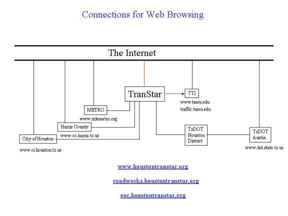
Figure 1 - Houston TranStar Internet links
Telephone Services - There is no formal telephone response system in
place, however the Houston TranStar center does receive calls from the public.
The system's operators answer these calls with the help of Metro Traffic Networks
personnel on the control room floor. The Texas Transportation Institute is
now conducting a 511 feasibility study. The City of Houston has just established
311 as the number to call for information regarding City services.
Kiosks - At one time, there were a number of public place kiosks as
a part of the Houston TranStar system. These, however, were deemed too expensive
to maintain and were often vandalized. Houston TranStar received a proposal
from a private company that was to take their information and place it in multi-function
kiosks in grocery and convenience stores, but the company that was to deploy
these machines did not return after the initial proposal.
Highway Advisory Radio and Dynamic Message Signs - Houston TranStar
will be operating a 12 station Highway Advisory Radio (HAR) system before the
end of 2001, and currently operates 88 Dynamic Message Signs (DMS) as well.
Institutional Environment
As noted previously, Houston TranStar is a partnership of the four transportation
authorities; the City of Houston; the Texas Department of Transportation (TxDOT);
Harris County; and the Metropolitan Transit authority of Harris County (Metro).
John Whaley, 713-881-3000 (jwhaley@houstontranstar.org)
is Director of Houston TranStar, and acts as the facilitator between the agencies.
There is an executive committee of four people, one from each of the agencies.
In fact, there is a three-tiered structure to the Houston TranStar management:
Executive Committee
- Director of Public Infra-Structure - Harris County
- President & CEO - METRO
- District Engineer - TxDOT
- Director of Public Works - City of Houston
Leadership Team
- Chief of Police - METRO
- Manager Traffic & Transportation Group - Harris County
- Emergency Management Coordinator - Harris County
- Director of Transportation Operations - TxDOT
- Executive Liaison - Harris County
- Emergency Management Coordinator - City of Houston
- Deputy Director of Public Works - City of Houston
Agency Managers
- Emergency Mgmt. Deputy Coordinator - Harris County
- Manager, Transportation Mgmt. Systems - TxDOT
- Captain, Houston TranStar Division - METRO
- Information Resources Administrator - TxDOT
- Emergency Mgmt. Deputy Coordinator - City of Houston
- Traffic, Deputy Assistant Director - City of Houston
- Traffic Management & Operations, P.E. - Harris County
- Manager, Transportation Mgmt. Systems - METRO
Recent Changes
The cost of maintaining cameras and loops is an extraordinarily large sum,
however Houston TranStar and its partner agencies would be incurring these
charges regardless of whether there are private customers for their freeway
and traffic management systems. The costs for services beyond normal daily
business, such as extra distribution amps (DA's), racks, video ports, etc.
come to approximately $25,000 for the first year. If the maintenance costs
of these items went up or down, then the charges to the private sector may
change to reflect these costs.
Contract rates may be changing soon anyway, as the camera network expands
and technology changes. Changing to digital video, for example, will require
upgrades to the systems and such upgrades may be reflected in the fees that
are paid for access to these services.
Houston TranStar adopted the ITS America Privacy Principals and has other
policies in place that have initiated reprimands to certain agencies for, as
an example, using inappropriate video feeds or direction.
As noted above, there is no current TranStar Interactive Voice Response (IVR)
or automated (511-type) service, although METRO does have an IVR system to
assist customer service inquiries. Houston TranStar is currently negotiating
a service of this type. Also TxDOT operates a statewide toll-free number, 800-452-9292,
that provides construction and detour information. The partners are currently
looking into providing access from 511 through this toll-free number backbone.
The initial thoughts are for this to be a statewide system using the existing
information structure, and perhaps expanding to provide more traffic information
at a later date.
Additional thoughts are to use text-to-speech to take the current data from
the Houston TranStar database and convert it to speech for the 12 HAR sites
that are being installed around the state. Perhaps at a later date, this may
also be used to provide information to an expanded IVR service.
Overview
Description
AZTech is a seven-year project (two-year implementation and five-year operation)
public-private partnership between a total of 13 agencies including the Arizona
Department of Transportation (ADOT) and the Maricopa County Department of Transportation
(MCDOT) to develop an integrated Intelligent Transportation System for the Phoenix
metropolitan area. Both ADOT and MCDOT have a leadership role in managing the
project and with mutual support responsibilities. There are also working groups
with participants from different agencies in the area. AZTech is administered
by MCDOT and the team supporting the project companies. There are a number of
regional resources including ADOT, MCDOT, the participating cities, transit agencies
and a dedicated ITS staff to support local and regional deployment and operations.
ADOT operates the 24/7 Freeway Management System as well as a telephone system,
web site, and other dissemination platforms. All operate from within the Freeway
Management Center. The main output is through the web site
http://www.azfms.com, which provides links to area road conditions and
traffic cameras as well as links to other area transportation resources.
Contractual Relationships
There is competitive participation in the AZTech project. Private partners are
chosen from a procurement process that encourages public/private partnership
participation, with all partners offering additional value to the AZTech program.
Private companies participate in AZTech in exchange for valuable data, which
they include in their enhanced products. The agreements are for a data exchange
only, no fees are paid nor revenue shared or exchanged. The travelers receive
the benefit, while AZTech relies on the private partners expertise to create
a market and distribute the information as widely as possible.
AZTech develops customized contractual agreements with its partners, as each
partner brings something of their own to the table. Sometimes if additional
services are required (such as data connections or fusion), the partner pays
for some portion of the process, such as the collection or fusion of data.
There are fiber connections to all of the public agencies and all 8 traffic
management agencies. AZTech will allow a private company a unique "socket" to
push and pull (contribute and extract) information from the system, using the
Internet as a portal to their systems. The main focus is always on maintaining
the network.
Business Model Type
AZTech can be viewed as a non-exclusive franchise agreement with private companies
selected through procurement process or adding their own unique value, connecting
to the AZTech systems. The non-exclusive franchise model allows for multiple
companies to partner or participate with the public sector in an ATIS service.
Each is given equal access to DOT data and is free to use this data to create
or enhance products of their own design (whether free or fee based).
Physical Infrastructure and Services
Data Collection
Approximately 90% or more of the data coming into the AZTech system is from public
sector sources. There are ten agencies who have workstations and are able to
input data, another 5 are expected in 2001. All data entered is shared by the
agencies through their AZTech workstations. Though anyone can view the data on
the Internet, but the workstation gives the agencies the opportunity to add information
on their own. Previously, the construction schedules and restriction planners
would call their information in to the AZDOT public relations office for distribution
to newspapers, etc. With the new AZTech workstations, road closure/restriction
software provides a listing of closures, or detours generated directly from the
city's AZTech workstation, to the media.
Below is a detailed list of infrastructure used for data gathering:
- Freeway Management Systems infrastructure:
- 60 Closed-Circuit TV Units,
- 40 Variable Message Signs,
- Vehicle detection system at every third of a mile.
- Smart Corridor infrastructure:
- Eight Closed-Circuit TV Units,
- 10 Variable Message Signs,
- Approximately 500 detection loops,
- 13 interconnected traffic operation centers.
- Road Condition Reporting System (RCRS) consists of workstations:
- Chandler (1),
- Gilbert (1),
- MCDOT (1),
- Scottsdale (1),
- Tempe (3),
- Glendale (4),
- Mesa (5),
- ADOT (189).
- 14 Traffic Management Work Stations capable of CCTV control,
volume/occupancy/speed monitoring.
Additionally, AZTech has installed Automatic Vehicle Location (AVL) devices
on 96 buses to track them as they travel their routes. These buses have the
ability to provide real-time schedule information to bus passengers.
Data Fusion
The data that is brought together in the AZTech system also include input from
the private sector partners. Etak/Metro, for example, enter data into the system
as an authorized partner, and the information will be available to any other
user or viewer on the AZTech system.
The AZTech servers are networked together as is the ADOT 888-411-ROAD telephone
system. The database keeps the telephone system updated and information organized
by region, city and then to a smaller area (such as a highway or highway segment).
Information Dissemination
Basic traveler information is available to the public through the Internet (http://www.azfms.com)
and through an IVR telephone system (888-411-ROAD). The web site and its
information are accessible to anyone including the media, who can read text directly
from the web site, or have the data repackaged for them through an ISP.
The ADOT web site shows information on Freeway conditions, road closures and
restrictions as well as images from ADOT's traffic monitoring cameras along
the freeways.
The 888-411-ROAD is run managed by ADOT as well. A recent upgrade took
the system from 8 to 24 phone lines and contains information across the state.
The system uses text-to-speech from the main database to keep the systems in
synch. This also allows for a quicker flow of information through the system
(entered once and available immediately on the IVR system). However it sometimes
takes a few minutes to "drill
down" the statewide menu. ADOT is investigating using speech recognition
in a future upgrade to eliminate this issue.
ADOT video (viewable on the web site) is available in real time to broadcasters.
On completion of an agreement with ADOT, broadcasters may connect to the ADOT
video distribution system. There are contracts with all 5 major broadcasters
to maintain their own connections to their own port on the switch allowing
them to pick from the 60+ video cameras on the system. Through their agreements,
ADOT has the capability and right to override or blackout certain images if
they believe them to be of a sensitive nature.
ETAK/Metro maintains a connection to the system, and AZTech has selected TANN
(Travel Advisory News Network) and Traffic.com as new AZTech partners
for data dissemination during phase 3 of the deployment. There are a total
of 10 private partners taking AZTech data, adding their own value and distributing
to the public.
Other dissemination platforms include:
- 23 Information Kiosks (72,000 average hits per month)
- Traveler information on the internet (
www.azfms.com,
www.etak.com,
www.SmarTraveler.com,
www.trafficstation.com)
- Wireless Application Protocol Phones providing traveler information
- Palm VII Personal Assistant providing traveler information
- FM Sub-carrier Broadcasts
- Live Traffic Information Feeds for common carrier radio, TV
- Route Customized Information Services (Phone, Internet)
- Traffic Information Broadcast on Demand (Command Audio)
- Traffic Information for Commercial Vehicle Operations (Transmart)
There is also a cable TV program offering traffic video and data through TeleAtlas
(formerly Etak). TeleAtlas has agreements with the city of Tempe and Glendale
(and two more in negotiations), wherein the "TrafficCheck" program
runs on local public access channels.
Transit information is provided through kiosks at transit centers provide
information on bus routes, schedules and traffic conditions.
Institutional Environment
Players
- US Department of Transportation
- Arizona Department of Transportation (ADOT)
- Maricopa County Department of Transportation (MCDOT)
- Cities of Chandler, Gilbert, Glendale, Mesa, Paradise Valley, Peoria, Phoenix,
Scottsdale and Tempe
- Maricopa Association of Governments
- Arizona State University
- Regional Public Transportation Authority;
- Sky Harbor International Airport
- City of Phoenix Public Transit
- City of Phoenix Fire Department
- Advanced Digital Systems
- BRW, Inc.
- Computran Systems Corporation
- Etak, Inc.
- Fastline Inc.
- Kimley-Horn and Associates
- PBS&J
- TrafficStation
- SmartRoutes
- Transmart
- Metro Networks
- TRW Transportation Systems
- Qwest
- Contractors West
- Orion Security Services
- American Electronic Signs
- TouchVision
- CUE Corporation
ISPs that operate in the region
- Metro Networks
- TeleAtlas (Etak)
- Traffic.com
- TANN
- Trafficstation[6]
ISPs that have access to data
As noted above, any ISP can access ADOT data through the AZTech servers and agreements
with ADOT and MCDOT. Those listed above have access to the data, and video is
available to all 5 major television broadcasters in the area.
Recent Changes
ADOT is aware of and actively watching the development of the 511 dialing
code for ATIS. Their current 888-411-ROAD number could be converted to 511
statewide. For now, ADOT is managing and funding the existing line, and will
have to assess what extra costs might be encountered should they change to
511.
Also, the system currently uses a drill down menu and text-to-speech output,
and ADOT is interested in exploring voice recognition in order to circumvent
the drill-down options, making for a safer and easier system which will, undoubtedly,
have higher calls volumes than are experienced now.
Overview
Description
The Metropolitan Transportation Commission's (MTC) TravInfo® project began
development on June 1, 1993, after being selected by the US Department of Transportation
as a demonstration project. It began live operations in August 1996 as a telephone
service designed to disseminate detected data directly to the public. At the
time, no one saw the Internet as a medium for such pointed dissemination. The
$9.1 million project was designed to provide raw data to the private sector with
the belief that private companies would find ways to create and sell new products
to individuals and companies. The publicly supported portions of the project
were data gathering (through CalTrans sensors and video cameras), and dissemination
through the TravInfo® telephone service.
The telephone service was unique in itself, as there was a single 7-digit
number, 817-1717, available in all four area codes (at the time) in the Bay
Area. Through area code splits and overlays, this has ceased to be the case.
Now only callers from six area codes in the Bay Area (415, 650, 408, 510, 925,
707) are able to dial 817-1717 directly. Callers from outside the Bay Area
must first dial any one of the six area codes and then dial 817-1717. Also,
due in part to the recent splits and overlays, though the TravInfo®
service is free, Local Toll charges may apply depending on the origination
of the call.
[7]
For a variety of reasons, the project did not work as planned. The data being
provided to the private sector was not at the level expected, and the market
share was not yet built up enough to sell a new line of service. Further information
on the TravInfo®
project is available at
http://www.travinfo.org.
In 1998, MTC issued a new Request For Proposals (RFP) to operate and maintain
the TravInfo® service. The new project is designed to provide data directly
to the public through the telephone system, and a Web site. Though the
contract still allows that raw data will be provided to the private sector,
the MTC has the right and ability to engage in other dissemination platforms
if they believe that the private sector is not doing enough to "get the
information out." This may include setting up products
in competition with the private sector.
Contractual Relationships
The current TravInfo® contract is a Design, Build, Operate and Maintain (DBOM)
contract with PB Farradyne. It calls for PB to rebuild the data collection network,
data fusion and dissemination systems including a web site and the IVR telephone
system. As a sub-contractor, Trafficstation was to act as broker for private
sales and build a new TravInfo® web page.
Revenue from these private sales was to be shared between Trafficstation and
TravInfo®.
Trafficstation has come under financial strain that has shut down their own web
site, and their status on the project is unknown at this time. The implementation
phase of the project is still the responsibility of PB Farradyne, who may seek
another sub-contractor, if necessary, to complete the Trafficstation portion
of the contract.
Currently, any entity (as a registered participant) may have access to TravInfo® data
in digitized form through a Landline Data Server (LDS) - Telnet connection.
Any interested firms and local public agencies can access this information
free of charge and reformat or re-use the information for their own products
and services. The only requirement is that they sign a usage agreement with
PB Farradyne. The agreement provides that usage figures for their dissemination
medium are reported to MTC, and requires that they not degrade the data in
any way, though they may enhance it.
There are two types of agreement available to participants and disseminators;
a Disseminator's Agreement, and an agreement created for use of the CCTV systems
for information. A copy of the Data Disseminator's Agreement is available
as
Attachment A - DATA DISSEMINATOR AGREEMENT. All agreements are with CalTrans
and the California Highway Patrol (CHP).
Business Model Type
The TravInfo® system can be viewed as both a Fee for Service and a
Partnership. Travinfo® is fully funded (at $38 million over six years) for
the development of data collection, management and fusion, and dissemination.
The project was never designed to bring money back into the project. However
there is a Business Model section of the agreement that calls for some revenue/cost
recovery through advertising and "up-selling" of
enhanced services through the IVR service. CalTrans may not want to recover money
that has a base in data gathering infrastructure set on their right of way (as
these are publicly funded sites and equipment).
CalTrans is currently working on a statewide traveler information policy that
would address issues such as these data and revenue issues.
Physical Infrastructure and Services
Data Collection
MTC has been working for a number of years to get CalTrans video cameras on line
and available to the TravInfo® operators. Currently, they are using Caltrans
loop sensors to monitor speed data on covered freeways. There are approximately
500 loop sensors and between 80-130 video cameras monitored through the CalTrans/TravInfo® connections.
PB Farradyne will be adding their own data collection system using electronic
monitoring through toll-tags or floating car data from US Wireless.
CalTrans is also adding new cameras, as well as non-intrusive sensors (RTMS)
as a part of their Traffic Management system. These images will also be available
to TravInfo®, however
TravInfo® operators will have no control over them.
Data Fusion
PB Farradyne is responsible for fashioning the infrastructure to fuse CalTrans
data into a new database called "The Framework." Standard ITS Data
dictionary and message set protocols will be incorporated in the new system through
the PB update. This is a customized version of the same system PB deployed for
Transcom in New York. Though the standards themselves are a "moving target," TravInfo® will
much better reflect the standards when the project is completed.
The system will interface to CalTrans data gathering systems or any sensors
that are deployed as a part of the TravInfo® project. Data is brought into
the data fusion server using standardized protocols. Once the sources are brought
together they are duplicated to data dissemination server, from which disseminators
retrieve data through a publish and subscribe system.
Information Dissemination
The Bay Area's TravInfo® service offers users access to real-time traveler
information 24 hours a day, seven days a week with operators gathering information
from a variety of sources. The Traffic Information Center (TIC) is currently
located in the CalTrans District 4 Headquarters in Oakland, CA.
TravInfo® IVR telephone service usage is over 60,000 calls per month.
Between 50% and 60% of callers cross-connect (call transfer) to any one of
the partner transit or public transportation agencies. Callers from the six
area codes in the Bay Area (415, 650, 408, 510, 925, 707) are able to access
the service via landline phone at 817-1717. AT&T
Wireless (formerly CellularOne) wireless users, can dial #817 from their
wireless telephone. No other wireless carriers offer abbreviated access at
this time.
The current IVR menu covers most of the interstate highways, a number
of state highways and expressways, and some major thoroughfares. Overall, 44
selected roads in five separate regions are covered Additionally, there is
coverage of the Bay Area bridge crossings
and information from approximately 59 transit or public transportation
agencies. From the top level, a user is given the choice of accessing transit,
traffic, car/vanpool, construction, parking and alternative transportation
information, or questions and comments. The web page, http://travinfo.org/about_817.htm shows a breakdown of the current
menu structures. As the new system is implemented, an automated voice system
will "read" directly
from the new Framework database. Users will hear their information either in
concatenated sentences or text-to-speech (depending on the specific incidents
reported).
There is no "official" TravInfo® web page for traveler information
at this time, though one is required in the new contract. For online access
to ATIS information, users may start at http://travinfo.org/online_traffic_reports.htm and select a partner
link from the list shown.
Direct dissemination from TravInfo® to private entities is through a Telnet
feed containing speed data on freeway links, incident data from California
Highway Patrol (CHP) and other sources. This is a continual feed updated as
conditions change. If a radio station wanted to use this data, they could.
However an interface to the database would need to be written as this output
is tabular with sensor numbers and results only.
The final output of the new TravInfo® system will be a user-friendly Web
page, as well as an update to the TravInfo® telephone system. There will
also be an enhanced data feed to private sector companies, utilizing the standards
mentioned earlier. One goal of the MTC is to use the 511 dialing code as the
number for TravInfo's® IVR service, thus
eliminating the difficulties encountered during the recent area code splits and
overlays.
The timetable for having new data fusion and data collection systems on line,
as well as implementing a 511 dialing code for the TravInfo® IVR system,
has all systems operating by Spring 2002. A number of the changes are running
in parallel, and one goal is to have a big marketing splash showing the enhanced
systems and new 511 code and web site all at once.
In addition to the Web and IVR updates, there are also plans for kiosks in
public places, as well as a desire to work with local TV stations and other
media. There is also the possibility of access to TravInfo® through web
enabled telephones and PDA applications. PB Farradyne is responsible for investigating
these new platforms. A system will be created for sharing CCTV video from TravInfo® systems,
the details of this system have not yet been worked out.
Institutional Environment
ISPs that operate in the region
Both Metro Networks and Shadow Broadcasting operate in the Bay Area. Metro Networks
was the previous TravInfo® contract holder, and WestwoodOne now owns both
companies.
Additionally, some of TravInfo's® many partners offer TravInfo's® traffic
information online including:
ISPs that have access to data
Though there is a video feed mechanism in place, the quality is not very usable
at this time. As such, there are no significant clients using the video feeds,
though some television stations are using "snapshots" on their web
pages.
Lessons Learned
TravInfo® began as a $9.1 million, two-year federal demonstration project.
TravInfo® was never designed to generate revenue or be self-sustaining.
The new TravInfo® contract is a $38 million six-year agreement between
MTC and PB Farradyne. Up to $25 million in federal and local transportation
funds will be allocated by MTC for the first four years of the new contract.
The contract calls for providing or upgrading systems and services to gather,
fuse, disseminate and market real-time traveler information on major roadways
and public transportation in the nine-county Bay Area. Again, TravInfo® is
not designed for revenue generation, though there are provisions for revenue
sharing, depending on the outcome of the business planning effort that will
get underway after the enhanced services are complete and operating.
Information will be accessible via a new TravInfo® Web site (as opposed
to linking to other partner's sites), a toll-free telephone number and other
dissemination methods, such as kiosks at key locations, cell phones and hand-held
computers. Additionally, it is expected that in the first two years of the
contract, the 817-1717 number will be converted to the newly approved 511 dialing
code.
The major goal is to increase the system's usefulness and therefore increase
the number of users. The goal is to have more than 10 million annual users
by 2004.
TRAVINFO®
DATA DISSEMINATOR REGISTRATION AGREEMENT
This Agreement, dated ______________, is entered into by PB Farradyne division
of Parsons Brinckerhoff Quade & Douglas, Inc. ("PBF"), and ______________________
("Registered Data Disseminator" or "RDD").
Background and Purpose
TravInfo® is the San Francisco Bay Area's Advanced Traveler Information
System (ATIS). PBF is the TravInfo® contractor for the Metropolitan Transportation
Commission ("MTC"), the contracting agency for TravInfo® on behalf
of itself and the other two TravInfo® partners, the California Department
of Transportation (Caltrans) District 4 and the California Highway Patrol Golden
Gate Division (CHP). TravInfo®
provides travelers with easy access to current and accurate information on
traffic conditions and multi-modal travel operation.
The Traveler Information Center ("TIC") gathers and integrates
information from a variety of sources, including (1) real-time data on traffic
conditions on the region's freeway system as collected by sensors operated
by Caltrans and MTC; (2) CHP incident reports; and (3) other available sources
of information. ATIS information (referred to in this Agreement as "Provided
Data") is made available to the general public, media, public
agencies, and commercial vendors to the extent feasible within the available
funding. Access to the Provided Data for Registered Data Disseminators is through
telnet connection.
A Registered Data Disseminator is a company or agency that is providing TravInfo®
data to end users, or is conducting product testing in anticipation of launching
a product or service that will do so.
Terms and Conditions
1. Registered Data Disseminator is entitled to redistribute, enhance, repackage,
or otherwise add value to the Provided Data. A detailed description of Registered
Data Disseminator's intended service or product, market, or business plan is
described in Attachment A of this Agreement. A non-disclosure agreement may
be negotiated on a case-by-case basis, as necessary between the RDD and PBF.
PBF may be required to share some or all of the information provided in Attachment
A with MTC, as part of PBF's monthly progress reports. Additionally, under
the California Public Records Act (California Government Code Sections 6250 et
seq.), MTC is required to provide non-exempt MTC
records relating to a Registered Data Disseminator, when requested by any interested
party.
2. PBF, MTC, Caltrans, and CHP reserve the right to publicize Registered
Data Disseminator's involvement in TravInfo® unless otherwise specifically
requested by Registered Data Disseminator in writing.
3. PBF is committed to maintaining a cooperative working relationship with
the Registered Data Disseminators to maximize the benefits to the public. It
is the intention of PBF that the TIC will compile the Provided Data from the
best available sources and will provide a best efforts approach to the dissemination
of such information.
Registered Data Disseminator will receive notices on TIC operational status,
including system maintenance schedules.
4. The Registered Data Disseminator must apprise PBF of Registered Data
Disseminator's product or service development and marketing plans, informing
PBF of any intermediate and/or other third-party data disseminators to whom
Registered Data Disseminator is providing TravInfo® data in any manner,
and providing PBF with monthly usage statistics. The specific type of usage
information and its reporting format will be negotiated between PBF and the
Registered Data Disseminator and set out in Attachment B to this Agreement.
The monthly usage statistics will include those of any down-stream data disseminators.
If the Registered Data Disseminator fails to report accurate usage statistics,
as defined in the aforementioned negotiation, PBF can, at its sole option,
terminate this agreement by a 15-day prior written notice delivered to the
Registered Data Disseminator.
5. The Registered Data Disseminator is cautioned that information availability
and data accuracy are all subject to change. Reasonable efforts will be made
by PBF to advise Registered Data Disseminator in a timely fashion of both expected
and unexpected changes in the operational status of the TravInfo® system.
Registered Data Disseminators are encouraged to contact the PBF TravInfo® Operations
Manager (phone (510) 286-6845) to report suspected system operational or maintenance
problems.
6. PBF reserves the right, at some future date, to charge for access to and
usage of the TravInfo® data. PBF will provide Registered Data Disseminator
90 days notice of such intent in order to negotiate any required revisions
to this Agreement.
7. PBF, MTC, Caltrans, and CHP and their suppliers make, and Registered Data
Disseminator receives, no warranty regarding Provided Data, whether express
or implied, and all warranties of merchantability and fitness of provided data
for any particular purpose are expressly disclaimed. PBF, MTC, Caltrans, and
CHP and their suppliers make no warranty that the information will be provided
in an uninterrupted manner or that the Provided Data will be free of errors.
Provided Data is provided on an "as is" and "with
all faults" basis, with the entire risk as to quality and performance
with Registered Data Disseminator.
In no event shall PBF, MTC, Caltrans, and CHP or their suppliers be liable
for any damages, claim, or loss incurred by Registered Data Disseminator, (including,
without limitation, compensatory, incidental, indirect, special, consequential,
or exemplary damages, lost profits, lost sales or business, expenditures, investments,
or commitments in connection with any business, or loss of any goodwill) resulting
from loss of Provided Data or inability to use Provided Data irrespective of
whether MTC, PBF, and its suppliers have been informed of, knew of, or should
have known of the likelihood of such damages, claim, or loss. This limitation
applies to all causes of action in the aggregate, including, without limitation,
breach of contract, breach of warranty, negligence, strict liability, misrepresentation,
and other torts.
8. Registered Data Disseminator agrees to defend, indemnify, and hold PBF,
MTC, Caltrans, and CHP harmless from and against any and all liability and
expense, including reasonable defense costs and legal fees, caused by any negligent
or wrongful act or omission of Registered Data Disseminator, its agents, officers,
and employees, in the use, possession, or dissemination of ATIS information
made available from the TIC, to the extent that such liability may be imposed
upon PBF, MTC, CHP, and/or Caltrans, including, but not limited to personal
property damage, or injury to privacy or reputation. In addition, Registered
Data Disseminator shall indemnify, defend, and hold harmless, against such
liability and expense, the individual members of the PBF, MTC, Caltrans, and
CHP TravInfo® project team.
9. Any and all disputes that may arise between the parties to this Agreement
regarding its terms or regarding performance under this Agreement shall be
submitted to final and binding arbitration in accordance with Sections 1280
through 1294.2 of the California Code of Civil Procedure. The arbitrator's
award shall be final and binding on the parties and judgment may be entered
upon it by a court of competent jurisdiction. Either party may demand arbitration
by filing a written demand with the other party within 60 (sixty) days after
occurrence of the dispute. The costs of the arbitration shall be borne by the
losing party or in such proportion as the arbitrator determines.
10. This Agreement shall remain in force until June 30, 2002, and may be
earlier terminated by either party with or without cause by 30-day prior written
notice delivered to the other party to this Agreement. The termination of this
Agreement does not release Registered Data Disseminator from the responsibilities,
liabilities, or indemnification, outlined in this Agreement that might result
from Registered Data Disseminator's actions during the term of this Agreement.
11. All questions pertaining to the validity and interpretation of this Agreement
shall be determined in accordance with the laws of the State of California.
The PBF contact for any questions regarding this agreement is Les Jacobson,
phone (206) 382-5290, e-mail jacobsonl@pbworld.com.
The contact for the Registered Data Disseminator is __________________, phone
__________, e-mail _______________.
|
For PBF
By____________________________
Lawrence F. Yermack
Vice President
Parsons Brinckerhoff Quade & Douglas, Inc.
3200 Tower Oaks Blvd
Suite 200
Rockville, Maryland 20852
|
For the Registered Data Disseminator:
By_______________________________
Name: __________________________
Title: __________________________
Address:___________________________
__________________________
__________________________
__________________________
Phone: __________________________
Fax: __________________________
Email: __________________________
|
Attachment A
Insert text regarding Registered Data Disseminator's TravInfo®-related
product(s), service(s) and methods for calculating and providing usage statistics
here. Describe the product(s), service(s)and methods for calculating and
providing usage statistics as specifically as possible.
Attachment B
Insert text describing the specific type of usage information and the
reporting format for monthly usage statistics.
Overview
Description
The Washington State Department of Transportation (WSDOT) has six regions plus
a Headquarters organization to coordinate all ATIS projects.
An IVR telephone service provides traffic information; road condition reports;
construction info and mountain pass information. In the greater Seattle area,
the local number is 206-DOT-HIWY (206-368-4499). A toll-free number, 800-695-ROAD
(800-695-7623) is available for users outside of the local Seattle calling
area. All systems for fusing and disseminating information are based at the
Seattle Traffic Management Center. The individual regions post reports on
the system. Each region has a
"slot" in which to record information pertinent to their area. They
are to update their information periodically or as necessary. Since the DOT
regions may not be clear to some end users, the information for dissemination
is broken down by county and by roadway.
There are individual web sites operated by the each region as well as other
public agencies providing traveler information in Seattle and Washington State.
Two of these sites might be considered "gateways."
- The WSDOT site (
www.wsdot.wa.gov) is a gateway to mostly highway and freeway related
information. While there is also a link for transit and ferry information,
as well as some arterial information, this site provides links to each
region's sites as well.
- The Smart Trek web site (
www.smarttrek.org) is a gateway to regional, multi-modal traveler
information for the Puget Sound area. It provides the WSDOT freeway traveler
information via a link to the WSDOT site and it provides access to several
transit traveler information applications. The Smart Trek program is the
result of a $13.7 million Model Deployment Initiative (MDI) demonstration
project launched in 1998. Under the MDI Project, 25 northwest public agencies
and private companies directed 27 projects designed to build upon the region's
significant investment in intelligent transportation system (ITS) infrastructure.
At this point, most Internet users access their information through the WSDOT
site. The agencies involved are looking to create a single "home" site
that can be marketed as a portal to all of the available traveler information.
The site will likely be based on the current "rWeather" web site
(
http://www.wsdot.wa.gov/rWeather), which will be marketed more aggressively
to the public. There was a marketing component to the Smart Trek program,
but the DOT site is not marketed a great deal at this time, receiving most
of its marketing through word of mouth and "best of the web" features
in the local and national press. Current plans are to drop the Smart Trek
site once a new portal site is on line, with King County Metro Transit taking
over the transit applications currently offered through Smart Trek.
Contractual Relationships
There are no formal contractual relationships with traffic information providers,
and no revenue or payment is exchanged for information. Loop traffic data is
available to any party that wishes to use the University of Washington "tool
kit." The tool kit
allows users to pull information directly from the ITS backbone over the Internet.
Any party that wishes to, can access this raw data, or link directly to the
DOT web site at no charge. Traffic providers, such as Metro Networks, view,
and are free to broadcast the information without restriction.
Local television stations are able to view and use the information as well,
and they are also able to re-broadcast video and web maps directly for no fee.
With regard to video, broadcasters are asked to sign a "Letter of Understanding," allowing
them direct access to any of the DOT cameras. They do not, however, have control
of the cameras, and must pay for their own infrastructure (microwave, video
switch) to connect to the DOT feed. A sample of this agreement is available
as Attachment A - KING TV.
The agreement states that the DOT offers no warranty on the availability of
the video or data, and either party may cancel the agreement with 30 days notice.
WSDOT has recently added the capability to blank a video image in the event
that sensitive images are being observed and they do not wish to have them
broadcast.
There is also a "Terms of Use" agreement with regard to "framing"
the web site within the structure of another site, such as a local newspaper
or other information site. A sample of this agreement is available as Attachment
B - Terms of Use for Puget Sound Traffic Internet Site.
As this system is, in fact, combination of multiple systems, there are some
individual agreements between some agencies, to provide data and video reciprocally.
This is a fairly "loose" arrangement, and in some cases, such as
with the cities of Bellevue and Seattle, the cost of providing the feeds to
each other might be shared between the two agencies. A sample of the agreement
between the city of Bellevue and WSDOT is available as Attachment
C - City of Bellevue and WSDOT Agreement. Future connections might
provide opportunities to cost share with other projects and agencies.
Business Model Type
This business model may be viewed as a non-exclusive franchise model, however
the open relationship with those who wish to access and re-use the DOT information,
makes it a truly open model.
Physical Infrastructure and Services
Data Collection
In the greater Seattle area, WSDOT has over 250 video cameras monitoring traffic
conditions along major freeways. Additionally, there are "slow-scan" or "snapshot"
video cameras monitoring conditions along the mountain passes, ferry terminals
and border crossings between the US and Canada, and arterial video from Bellevue
and Seattle.
Most of the regions use loop detectors for speed and lane occupancy measurement.
The regions that have major urban areas also have some form of urban detector
system, though it may not be large. The mountain pass area is monitored mostly
by human observation. Most of the information is collected as effort by WSDOT
or the individual regions to operate and monitor roadways.
Road/Weather conditions are monitored through 400+ weather stations around
the state with 40 of these along the various highways. These provide predictive
road surface temperatures, allowing the DOT and the regions to create a "plan
of attack" when the conditions
change.
There is a scanner in the TMC that allows operators to listen to pilots and
traffic reporters exchanging information between their operations centers and
client radio stations. There had been a relationship with one particular reporter
in the past, however that relationship ended as the reporter's "suggestions" turned
self-serving.
The second phase of a research project using Automatic Vehicle Location (AVL)
equipped buses as probe vehicles, will be starting soon. Information from 1200
buses in the Seattle area will be monitored to provide arterial traffic speeds.
Data Fusion
All information arrives at the Seattle TMC for fusion into the IVR system.
As previously noted, the regions are responsible for their own data and, in
most cases, are responsible for providing the content for their own web sites.
The format of the information pre-dates any ITS standards, and as such, is
mostly free-form text as entered into the database. One project, CARS (Condition
Reporting and Acquisition System), uses the Traffic Management Data Dictionary
(TMDD), but no other standards are being implemented. WSDOT is using NTCIP
standards where they are able, and will use standards where new systems are
being launched. But since the current connections and databases used by the
regions are in synch, the feeling at the moment is that there is no real need
to update the systems to new standards, though the new standards may be used
when these systems are updated.
The automated (loop data) is archived in several forms. All loop data is burned
onto a set of CDs every 6 months. Anyone who wishes can send for and receive
the CDs. Anyone who wishes can also go to the WSDOT web site and view a year's
worth of traffic congestion maps moving forward or backward in 10-minute increments.
The Washington State Transportation Center (TRAC) has Puget Sound freeway performance
data (e.g., what time of day does congestion occur and how long does it last?)
available on their web site
http://depts.washington.edu/trac/reports/reports.html.
The recording of messages for the IVR system is also in free form. The regions
are responsible for updating their own messages, whether they do so or not
is up to them. WSDOT contracts with a small telephone phone service provider
for 8 to 10 lines into the recording system. The Seattle operators record directly
into the system, and the region's operators record by calling in through one
of the available lines. Only the Seattle area operations staff updates the
messages daily. Most of the reports that are recorded from other regions are
construction reports that are updated weekly. The mountain pass reports, which
are available between October and April, are updated at least every 4 hours
during those times.
Information Dissemination
A statewide IVR telephone service provides information on traffic and road
conditions. In the greater Seattle area, the local number is 206-DOT-HIWY
(206-368-4499), and since
information is statewide, a toll-free number, 800-695-ROAD (800-695-7623) is
provided for users outside of the local Seattle calling area. The number is
advertised through periodic postings on VMS signs, and is included in press
releases regarding construction restrictions and other events that might cause
delays.
At one time, as an aging "Mountain Pass Information" telephone system
was in need of replacement, the state legislature decided that the state DOT
should attempt some form of cost recovery for replacement and continued operation.
There was a "900"
number charging 35¢ per call, during which time the system received approximately
300,000 per season (October - April). Though the service was used, call volume
was not as anticipated, and users or potential users began to "dial-around" the
DOT number, instead calling directly to the state police. The legislature realized
that cost recovery was not likely, and removed the requirement from the DOT,
paving the way for a (fully funded) local/toll-free number combination instead.
With this, the call volume increased to 1 million per "winter" season
(4000+/- per day mountain pass and 4000 +/- per day for traveler information).
These numbers remain fairly constant, though this depends on weather conditions
or if there is a major incident that receives broadcast attention, thus causing
call volumes to increase.
As noted previously, the "official" Washington State DOT site,
http://www.wsdot.wa.gov provides some information, and links to other
sites maintained by the various regions, as well as a site that provides schedule
and fare information on the ferries. The Smart Trek web site,
http://www.smarttrek.org, provides a portal to these various DOT
and Transit sites including the Vessel Watch project. The Vessel Watch project
that provides ferry location information to people over the Internet also
provides ferry management with information about which vessels are on which
runs, which captain and crew are on the ship and on-time performance.
At one time, kiosks were deployed in the area, but they were not accepted
as well as expected. There is currently a new kiosk in downtown Seattle using
the Fisher Broadcasting (TV) network. The kiosk offers traffic and transit
information but is not directly connected to WSDOT. Instead, the machine contains
a web browser that points to the WSDOT web site for traffic and to the Smart
Trek site for transit information.
There is an application for the PalmVII Personal Digital Assistant that sends
users to a Palm version of the DOT web site; and SprintPCS phones have an application
that retrieves transit arrival times from MyBus. MyBus is one of the transit
applications (transit arrival times) that is available on the Internet.
Institutional Environment
Players
Washington State has six regions and a Headquarters organization that coordinates
some ATIS projects. The regions are broken down as follows:
- Northwest Region
- Olympic Region
- Eastern Region
- Southwest Region
- South Central Region
- North Central Region
Pete Briglia - ITS program manager for Washington State DOT, works in the
ITS office. The ITS office is a part of the Headquarters organization, but
the people actually responsible for ATIS information are the regions.
ISPs that operate in the region
Metro Networks operates in the Seattle area, providing broadcast reports to
many local stations, as well as information through their partner Etak. However
the open business model in the area allows for much wider dissemination, such
that many local TV and radio stations provide their own information culled
from the DOT data or web site.
Some, such as KING-TV, provide links to other ISPs for additional feature
products. Strategy.com is one such link, and offers traffic alerts via
e-mail, pager and web enabled phones. Others, such as KOMO or KCPQ, simply
provide links directly to the various region's traffic maps and cameras.
ISPs that have access to data
Most any ISP can access WSDOT information through the Internet. In order to
access a direct data or video feed, the ISP needs only sign a data use agreement.
Recent Changes
WSDOT is anxious to implement the 511 dialing code for their traffic telephone
system. They are currently working on a cellular phone voice-response (voice
recognition) system. The 511 would, therefore, be available to cellular users
far before it becomes available for landline users. The funding required to
implement this program would require backing with federal dollars. It is hoped
that the $100,000 USDOT offering to convert to 511 will aid in this matter.
WSDOT is also interested in a solution being investigated by Qwest Communications;
Qwest is looking at a 14 state solution for 511 where they will provide service
in
"bulk" to those who wish to implement an ATIS service. But the current
feeling at WSDOT is that this might take longer than it would take to implement
the wireless solution they are exploring at this time. Safety concerns of a
user having to "drill down"
a menu, while using a wireless phone, is one reason that WSDOT is looking at
a voice response/recognition system. That this solution corresponds to the
approval of 511 is an extra benefit.
The following constitutes a letter of understanding between the Washington
State Department of Transportation (WSDOT) and KING Broadcasting Company,
dba (KING).
BACKGROUND
WSDOT, as part of its Traffic Systems Management Program, monitors freeway
conditions in and around the Seattle metropolitan area. Two methods of monitoring
traffic conditions are used. The first method utilizes a closed circuit television
(CCTV) system in which the video is transmitted to a central location. The
second method utilizes electronic loop detectors placed in the roadway pavement.
The traffic information from the loop detectors is transmitted to a central
computer that converts the information into a color-coded map.
KING would like to present this information to the general public as part
of its programs. Presentation of this information is consistent with WSDOT's
policy of providing public information.
AGREEMENT
KING is hereby authorized the non-exclusive right to access WSDOT's traffic
monitoring information under the terms and conditions stated herein.
WSDOT will continue to monitor traffic in a manner consistent with the needs
of the Traffic Systems Management Program. KING agrees to monitor and use WSDOT-provided
information in a manner, as directed by WSDOT, that does not impact any of
WSDOT's operations or use in any way.
Public broadcasts of video from WSDOT's CCTV system shall indicate that the
video is provided by WSDOT.
KING shall supply all required equipment, as reasonably determined by WSDOT,
needed to tap into WSDOT's systems at the demarcation point stated herein,
and to transmit this information back to KING's building. KING will retain
ownership of this equipment and therefore, all costs and responsibility for
purchasing, installing, and maintaining this equipment shall be KING's responsibility.
Any damage to WSDOT equipment and/or facilities resulting from KING's operations
shall be repaired at no cost to WSDOT. WSDOT will be responsible for determining
how the damage is to be repaired and who will make the repairs. KING agrees
to reimburse WSDOT its reasonable costs and expenses incurred within thirty
(30) days of the date of WSDOT's invoice.
Should any of KING's transmitting equipment impact WSDOT's operation in any
way, KING shall immediately remedy the situation in a manner satisfactory to
WSDOT. KING shall be responsible for all licensing requirements. Failure to
remedy transmitting equipment impacts or comply with licensing requirements
shall, at WSDOT option, result in the immediate termination of the agreement.
This agreement is solely between WSDOT and KING. The following companies are
divisions of KING and are covered under this agreement:
- KING 5 Television,
- NW Cable News.
Should another business or person wish to receive WSDOT's traffic information
through KING, that party must enter into a separate agreement with WSDOT.
KING will access WSDOT's video signal at a demarcation point in the basement
of WSDOT's Roanoke building located at: 811 East Roanoke Street, Seattle, WA
98102-3915. The demarcation point will be a standard BNC connector terminating
the WSDOT equipment. WSDOT will define the demarcation location. WSDOT may
move the demarcation point at WSDOT discretion. WSDOT is responsible for the
video signal between its equipment and the demarcation point. The signal between
the demarcation point and KING's building is the responsibility of KING. All
access to the building by KING will require prior notification and arrangement
with WSDOT's Northwest Region Freeway Operations Engineer, at phone number
(206) 440-4463.
Should any conflict arise between the activities covered under this agreement
and existing or future federal or state policies, rules or regulations, this
agreement will be discontinued on fourteen (14) days written notice at the
discretion of WSDOT.
KING acknowledges that WSDOT is currently researching potential leasing and
fee requirements regarding KING's use of WSDOT facilities for their equipment
which may result in the termination of this agreement with thirty (30) days
written notice from WSDOT. Should such a termination result, a new agreement
may be drafted with the approval of both parties that may result in additional
expenses to KING.
KING agrees to indemnify and hold WSDOT harmless against any claims or actions
by third parties from misconstrued or inaccurate information disseminated by
KING. Further, KING will protect, save, hold harmless and defend the WSDOT,
its authorized agents and employees, from all claims, actions, costs, damages,
or expenses of any nature whatsoever (including reasonable attorney fees and
costs) by reason of the acts or omissions of KING, its agents, service providers,
contractors, licensees, invitees, or employees arising out of or in connection
with any acts or activities authorized by this letter of understanding. This
obligation shall not include such claims, costs, damages, or expenses which
may be caused by WSDOT or its authorized agents or employees; PROVIDED, that
if the claims or damages are caused by or result from the concurrent negligence
or other acts or omissions of (a) the WSDOT, its agents or employees and (b)
KING, its agents, service providers, or employees, this indemnity provision
shall be valid and enforceable only to the extent of the negligence of KING
or KING's agents or employees.
WSDOT shall not be held liable if any or all of WSDOT's system is not operational.
If for any reason any of the terms of this agreement are violated by either
WSDOT or KING, the innocent party may terminate, with thirty (30) days written
notice to the defaulting party.
This agreement shall commence on the date of signing and continue without
interruption for five (5) consecutive years. However, either WSDOT or KING
may terminate without penalty this agreement at any time during the five year
period upon 30 days written notice.
If you are in agreement with the terms and conditions set forth in this letter,
please sign in the space provided below and return the original to this office.
Signature below signifies agreement with the above listed terms and conditions.
|
King Broadcasting Company
Name ____________________________
Title President & G.M. of KING-TV
Date ____________________________ |
WSDOT Representative
Dave Berg, P.E.
Title Traffic Operations Engineer
Date ____________________________ |
Please read these terms carefully before using this site. By using this site,
you agree to these terms of use. If you do not agree to these terms of use,
please do not use this site.
General
This site is owned and operated by The Washington Department of Transportation
(Referred to as "WSDOT"). WSDOT reserves the right to change or discontinue
any aspect or feature of the site at any time.
WSDOT provides this website as a public service. This website is used to provide
many types of information and to provide access to other traffic related information.
All information on this web site is provided "as is" without warranty
of any kind.
Restrictions on Use
The content of this site, including all text, graphics, compilations and other
documentation, is the property of WSDOT and is protected by copyright law.
By using this web site, you agree to abide by all applicable laws in connection
with our property rights, and by these terms of use. Except as otherwise provided
in these terms, you may not publish, display, distribute or commercially exploit
any of the content without the express written permission of WSDOT and the copyright
owner.
Redistribution
No part of this web site, whether complete or otherwise, may be set within a
"frame" of another web site, without the express written consent
of WSDOT. If you operate a website and would like to utilize information provided
by this site, we require that you not frame or link to specific portions of
our site, but instead provide a link to http://www.wsdot.wa.gov/PugetSoundTraffic/.
External framing or linking to specific images, graphics or text decreases
the visibility of the remainder of our site and hampers our effectiveness.
In the event of any permitted redistribution or publication of copyrighted
material, no changes in or deletion of author attribution, trademark legend
or copyright notice shall be made. You acknowledge that you do not acquire
any ownership rights by downloading copyrighted material.
Disclaimer of Warranty; Limitation of Liability.
WSDOT attempts to provide the best service reasonably available, but situations
will occur that disrupt service or cause misinformation. The material presented
on this website cannot be guaranteed as to accuracy or timeliness. This information
depends on a number of items, including Internet availability, communications
networks, and computer equipment which are beyond the control of WSDOT and difficult
to predict.
Because weather, road and traffic conditions change rapidly, drivers are in
the best position to perceive such conditions and adjust their driving accordingly.
Those relying on information presented on this site do so at their own risk,
and neither the State of Washington, WSDOT nor any of their employees or agents
shall be liable for either the accuracy of this information nor any actions
taken based on the information.
All information on this web site is provided "as is" without warranty
of any kind, either express or implied, including, but not limited to, the
implied warranties of merchantability, fitness for a particular purpose, or
non-infringement. WSDOT assumes no responsibility for errors or omissions in
the information or software or other documents which are referenced by or linked
to this web site. Under no circumstances, including, but not limited to, negligence,
shall WSDOT or any contributor to this web site be liable for any direct, indirect,
incidental, special or consequential damages that result from the use of, or
the inability to use this web site or its content.
We welcome feedback on the website at nwflow@wsdot.wa.gov,
but provide no guarantee that feedback will result in site changes. If you
are dissatisfied in any way with any of these terms of use, your sole and exclusive
remedy is to discontinue use of this site.
Indemnification
If the State of Washington or WSDOT is involved in litigation as a result of
your use of our site, you agree to pay to costs associated with defending the
State of Washington and WSDOT, and any resulting liability.
Third Party Content.
WSDOT provides links to Internet sites maintained by third parties. Because we
do not operate or control any of these sites, we cannot be responsible for their
content.
Changed Terms.
WSDOT has the right at any time to change or modify the terms and conditions
applicable to use of the site or to impose new conditions. Any use of the site
indicates that you accept the terms and conditions as posted at the time of use.
Miscellaneous.
These terms of use constitute the entire agreement of the parties with respect
to the subject matter hereof and supersede all previous written or oral agreements
between the parties with respect to such subject matter. These terms of use shall
be construed in accordance with the laws of the State of Washington. No waiver
by either party of any breach or default hereunder shall be deemed to be a waiver
of any preceding or subsequent breach or default. The section headings used herein
are for convenience only and shall not be given any legal import. Comments or
questions about this site or the terms of use should be directed to nwflow@wsdot.wa.gov.
Terms of use last updated on 3/15/2000
The following constitutes a letter of understanding between the Washington
State Department of Transportation (WSDOT) and the City of Bellevue (City)
BACKGROUND
WSDOT, as part of its Traffic Systems Management Program, monitors freeway
traffic conditions in the greater Seattle metropolitan area. One method of
monitoring conditions utilizes a closed circuit television (CCTV) system in
which the video is transmitted to a central location.
The City, as part of its traffic and signal operations system, monitors arterial
traffic conditions in the Bellevue metropolitan area. One method of monitoring
conditions utilizes a CCTV system in which the video is transmitted to a central
location.
WSDOT presents this CCTV information to the general public as part of its
programs. These include allowing local media and other public agency access
to real-time video images and display of continuously updated snapshots of
video images via the Internet. Presentation of this information is consistent
with WSDOT's policy of providing public information. The City does not currently
present this information to the public, nor does it have the means to.
AGREEMENT
The City is hereby authorized the non-exclusive right to access WSDOT's video
surveillance system under the terms and conditions stated herein. WSDOT is
similarly authorized the non-exclusive right to access the City's video surveillance
system under the conditions stated herein.
WSDOT will continue to monitor traffic in a manner consistent with the needs
of its Traffic Systems Management Program. The City agrees to monitor and use
WSDOT-provided information in a manner, as directed by WSDOT, that does not
impact any of WSDOT's operations or use in any way.
The City will continue to monitor traffic in a manner consistent with the
needs of its traffic and signal operations system. WSDOT agrees to monitor
and use City-provided information in a manner, as directed by the City, that
does not impact any of the City's operations or use in any way.
WSDOT will create and provide continuously updated snapshots of the City's
video images for display on the Internet. These will be accessible via a symbolic
map showing approximate camera location, shall include location information
with each snapshot image, and shall credit the City as the source of the images.
This will be done in a form consistent with WSDOT's existing video snapshot
display on the Internet and shall be acceptable to both the City and WSDOT.
The City shall supply all required equipment, as reasonably determined by
WSDOT, needed to tap into WSDOT's systems at the demarcation point stated herein,
and to transmit this information back to the City's building. The City will
retain ownership of this equipment and therefore, all costs and responsibility
for purchasing, installing, and maintaining this equipment shall be the City's
responsibility.
WSDOT shall supply all required equipment, as reasonably determined by the
City, needed to tap into City's systems at the demarcation point stated herein,
and to transmit this information back to WSDOT's building. WSDOT will retain
ownership of this equipment and therefore, all costs and responsibility for
purchasing, installing, and maintaining this equipment shall be WSDOT's responsibility.
The City will access WSDOT's video signal at a demarcation point in Levett
Building in Bellevue. The demarcation point is defined as the output of WSDOT's
video receiver. The City will maintain and repair as necessary the fiber optic
cable installed between WSDOT right-of-way and the Levett Building.
WSDOT will access the City's video signal at a demarcation point in Levett
Building in Bellevue. The demarcation point is defined as the output of the
City's video receivers.
Any damage to WSDOT equipment and/or facilities resulting from the City's
operations shall be repaired at no cost to WSDOT. WSDOT will be responsible
for determining how the damage is to be repaired and who will make the repairs.
The City agrees to reimburse WSDOT its reasonable costs and expenses incurred
within thirty (30) days of the date of WSDOT's invoice.
Any damage to City equipment and/or facilities resulting from WSDOT's operations
shall be repaired at no cost to the City. The City will be responsible for
determining how the damage is to be repaired and who will make the repairs.
WSDOT agrees to reimburse the City its reasonable costs and expenses incurred
within thirty (30) days of the date of the City's invoice.
Should any of the City's transmitting equipment impact WSDOT's operation in
any way, the City shall immediately remedy the situation in a manner satisfactory
to WSDOT. Similarly, should any of WSDOT's transmitting equipment impact the
City's operation in any way, WSDOT shall immediately remedy the situation in
a manner satisfactory to the City.
This agreement is solely between WSDOT and the City. Should another city or
other jurisdiction wish to receive (a) WSDOT's traffic surveillance video through
the City, or (b) the City's traffic surveillance video through WSDOT, the party
must enter into a separate agreement with the video source owner.
WSDOT has existing agreements with the following television stations, local
agencies, and companies for transmission and use of its real-time video images:
KIRO Television
KOMO Television
KING Television
KSTW Television
KCPQ Television (pending)
Microsoft
King County Metro Transit
City of Seattle (pending)
Washington State Patrol
University of Washington (pending)
These agreements allow each party non-exclusive use of the video images and,
in the case that the images are to be transmitted to the public via broadcast,
cable television, or the Internet, state that credit shall be given to WSDOT
for providing them.
WSDOT will block access to the City's video images from all parties that currently
have access to WSDOT's video, and to any future party requesting such. Access
will be permitted only after a written request from the City for each party
wanting use of the City's video images. It shall be the City's responsibility
to enter into agreements with said parties for use of the City's video images.
WSDOT's video distribution system allows the ability to provide access to
parties on a case by case basis. WSDOT will label each City video image with
location identification information. WSDOT's system does not currently have
the ability to include any information crediting the City as the source owner
of the video through a real-time connection, such as the connections used by
companies and agencies described above.
The City agrees to indemnify and hold WSDOT harmless against any claims or
actions by third parties from misconstrued or inaccurate information disseminated
by the City. Further, the City will protect, save, hold harmless, and defend
WSDOT, its authorized agents and employees, from all claims, actions, costs,
damages, or expenses of any nature whatsoever (including reasonable attorney
fees and costs) by reason of the acts or omissions of the City, it agents,
service providers, contractors, licensees, invitees, or employees arising out
of or in connection with any acts or activities authorized by this letter of
understanding. This obligation shall not include such claims, costs, damages,
or expenses which may be caused by WSDOT or its authorized agents or employees;
PROVIDED, that if the claims or damages are caused by or result from the concurrent
negligence or other acts or omissions of (a) WSDOT, its agents or employees
and (b) the City, its agents, service providers, or employees, this indemnity
provision shall be valid and enforceable only to the extent of the negligence
of the City or the City's agents or employees.
The WSDOT agrees to indemnify and hold the City harmless against any claims
or actions by third parties from misconstrued or inaccurate information disseminated
by the WSDOT. Further, the WSDOT will protect, save, hold harmless, and defend
the City, its authorized agents and employees, from all claims, actions, costs,
damages, or expenses of any nature whatsoever (including reasonable attorney
fees and costs) by reason of the acts or omissions of WSDOT, it agents, service
providers, contractors, licensees, invitees, or employees arising out of or
in connection with any acts or activities authorized by this letter of understanding.
This obligation shall not include such claims, costs, damages, or expenses
which may be caused by the City or its authorized agents or employees; PROVIDED,
that if the claims or damages are caused by or result from the concurrent negligence
or other acts or omissions of (a) the City, its agents or employees and (b)
WSDOT, its agents, service providers, or employees, this indemnity provision
shall be valid and enforceable only to the extent of the negligence of WSDOT
or WSDOT's agents or employees.
WSDOT shall not be held liable if any or all of WSDOT's system is not operational,
nor shall the City be held liable if and or all of the City's system is not
operational.
Should any conflict arise between the activities covered under this agreement
and existing or future federal, state, or city policies, rules, or regulations,
the agreement will be discontinued on fourteen (14) days written notice at
the discretion of the party affected by the conflict.
If for any reason any of the terms of this agreement are violated by either
WSDOT or the City, the innocent party may terminate with thirty (30) days written
notice to the defaulting party.
This agreement shall commence on the date of signing and continue without
interruption for five (5) consecutive years. However, either WSDOT or the City
may terminate, without penalty, this agreement at any time during the five
year period upon thirty (30) days written notice.
If you are in agreement with the terms and conditions set forth in this letter,
please sign in the space provided below and return the original to this office.
Signature below signifies agreement with the above listed terms and conditions.
|
City of Bellevue
Name _____________________________
Title ______________________________
Date _____________________________ |
WSDOT Representative
Name _____________________________
Title ______________________________
Date _____________________________ |
Overview
Description
In Florida, the SunGuide program is a cooperative effort of transportation
agencies throughout Southeast Florida's tri-county area. Broward, Miami-Dade
and Palm Beach counties are included in this program. The SunGuide program
includes Traffic Management, Traveler Information, SunPass (electronic toll
collection), and Road Rangers (motorist assistance) programs. Information on
SunGuide can be found at
http://www.sunguide.org.
The SunGuide Traveler Information Service was conceived to provide people
with the right information at the right time to improve the quality and convenience
of their trip and the overall performance of the transportation system. Florida
DOT District 6 manages the ATIS project for Florida in the three counties,
including administrative duties, invoicing and meeting notifications. A Project
Steering Committee made up of the public and private partners involved in
gathering and disseminating data leads the project. All other functions and
decisions are cleared by the Steering Committee, too.
For ATIS information, a separate web site and Interactive Voice Response (IVR)
telephone system are available to the users. The web site comes under the brand
name of SmartRoute Systems' SmarTraveler® service. The SmarTraveler® IVR
service is available to users in all three geographic areas through the use
of both a local and toll-free number combination. Users in the local dialing
area of Miami dial
305-914-3838[8], while
users from Broward or Palm Beach counties dial 866-914-3838. The last
7-digits of each number are the same for ease of memory.
Contractual Relationships
In 1998 an open Request For Proposals (RFP) was issued for installation, operations
and maintenance of an Advanced Traveler Information System for Southeast Florida.
SmartRoute Systems was chosen to deploy and maintain such a system. The contract
was awarded and signed in late 2000, and the new systems were launched in May
of 2001. The contract includes a requirement for an Internet Web site, and
Interactive Voice Response (IVR) telephone system. The telephone system is
multi-lingual, with menus and information available in both English and Spanish.
The ATIS component of the SunGuide program is a five (5) year $3.9 million
contract, with funding from both FHWA and FDOT. Payments are made over the
first three (3) years of the agreement, with revenue sharing proposed to cover
continued operation for years 4 through 5. The revenue sharing component includes
10% of the gross revenue from sales of products or advertising of the SmarTraveler® service
(or other services provided by SmartRoute) to be paid to FDOT. Once the revenue
reaches over $800,000 (cumulative over five years) the percentage returned
to the project increases.
Business Model Type
The agreement for ATIS services is a public/private partnership between public
agencies, such as, FDOT, and SmartRoute Systems. They share revenue and data
gathering infrastructure. Though there is a restriction on the use (or re-use)
of SmartRoute's enhanced data (i.e. FDOT may not pass any processed data or
data that has been gathered through SmartRoute's systems on to others), there
is no exclusivity regarding the FDOT data. Should another private entity, such
as a TV station or newspaper, wish to connect to and use the raw DOT data or
video, they are only subject to whatever obligations the DOT places with regard
to data use and connection.
Physical Infrastructure and Services
Data Collection
Data for the project comes from four separate previous and ongoing projects.
- The Golden Glades Interchange project, formerly known as the "Flamingo
Project", has deployed 10 DMS (Dynamic Message Signs) and 6 video
cameras on and around the Interchange, State Road 826, and I-95.
- The expansion of the Golden Glades project added 7 more cameras in places
where DMS signs already existed, bringing the total number of cameras for
the Golden Glades Interchange Project to thirteen (13).
- An additional project, known as SunGuide I-95 ICS Phase A added 27 cameras,
4 DMS signs and 16 detector stations on I-95.
- An additional 53 detector stations will be added to I-95 as a part of
the SunGuide I-95 ICS Phase B Project.
Phase A also involved the creation of the SunGuide Central System Software
to control all SunGuide I-95 ICS field equipment, plus two field communication
hubs. Also, a 17-1/2 mile long fiber optic truck along I-95 was deployed, carrying
data and video to the two field communication hubs. From there information
is delivered to the SunGuide Interim Operations Center (IOC) over two leased
T-3 lines.
Phase B will add 8 additional freeway DMSs, 8 arterial DMSs, 53 detector stations,
27 Trailblazers (another form of message signs that will offer alternate routing),
and 22 ramp signal sites. Phase B is scheduled to begin installation of the
infrastructure in June 2002.
Phase C will include the construction of a new SunGuide Transportation Management
Center. Phase C will begin in January 2002.
Additional FDOT data gathering takes place through 27 SunGuide Road Rangers
motorist aid vehicles. Out of these 27 motorist aid vehicles, 23 are small
tow trucks that have service capabilities to assist motorists in changing tires,
adding fluids, and other minor repairs. The Service Patrols are in radio contact
with the SunGuide Interim Operations Center (IOC)[9] regarding
incidents and delays on their covered roads.
From their operations center, SmartRoute's operators communicate by radio
with Florida DOT IOC personnel. SmartRoute is working to install a connection
allowing them to receive snapshots of the road conditions from FDOT video cameras,
as well as a data link to the DOT systems for travel times and incident data.
Prior to the start of this contract, FDOT personnel would often call Metro
Networks or Shadow Traffic offices to inform them of incidents or unusual delays
on the highways. Since the contract began, FDOT is only calling Smart Route's
operators in order to have the information placed in the database of the SmarTraveler® system.
However, since Westwood One, who also owns Metro Networks and Shadow Broadcasting,
now owns SmartRoute, each have some access to the information. Reciprocally,
SmartRoute has access to live video from the Metro Networks helicopter during
morning and afternoon rush hours.
Thanks to their common owner, SmartRoute personnel also receive information
from Metro Networks personnel to supplement their own newly developing data
gathering network. By contract, SmartRoute will be installing an additional
10 video cameras and will build a Mobile Probe network of system users and
other mobile resources.
Data Fusion
The FDOT systems take into account the sensor network and video cameras to
supply information to the Traffic Management Center (currently the SunGuide
Interim Operations Center). This data will be available for automated
processing by SmartRoute Systems as a part of the SunGuide ATIS project, and
will be fused into SmartRoute's WINGS database for output to the web site and
telephone system.
Information Dissemination
Information is disseminated through the
www.smartraveler.com web site. Users navigate to any of the Florida
links through a drop down menu, and click on roadways and other selections
for information.
A bi-lingual IVR system responds to callers in both English and Spanish at
305-914-3838 for local callers to Miami, and 866-914-3838 for
toll or long-distance callers to Miami. Though users may be calling from as
far away as Palm Beach, the system is wholly maintained in Miami, nearly 70
miles away.
There are also one or two agreements with small area newspapers that carry
links to the SmarTraveler® traffic information on their web pages.
Due in part to the recent dissent of the wireless carriers, and their re-petitioning
of the FCC with regard to the 511 dialing code, there are currently no carriers
that offer access to the Florida SmarTraveler® system through any abbreviated
access.
Institutional Environment
Partners
The SunGuide program is a service of:
- Federal Highway Administration (FHWA)
- Florida Department of Transportation (FDOT)
- Miami-Dade Metropolitan Planning Organization (MPO)
- Broward MPO
- Florida Highway Patrol
- Miami-Dade Expressway Authority
- Palm Beach MPO
- Tri-County Commuter Rail Authority
With the structure of the current contractual agreement with SmartRoute Systems,
SmartRoute is a "partner" in the program as well.
ISPs that operate in the region
Metro Networks also operates in southeast Florida, as did Trafficstation (who
recently ceased day-to-day operations). Etak Inc. provides traffic information
to a number of customers through their partnership with Metro Networks. For
example, traffic information is provided through MapQuest (
www.mapquest.com) as a part of this agreement.
ISPs that have access to data, how the access occurs and under what terms
Any provider who wishes to connect to the Florida DOT data or video feeds may
do so; however, ATIS-like contracts, data agreements, and so on would have
to be developed. There is no restriction in the current contract prohibiting
the creation of such agreements. However, there is a restriction with regard
to the re-use and/or sale of information that has been enhanced by SmartRoute
Systems, even if the basis of this information is publicly held DOT data.
Lessons Learned
The contract in Southeast Florida is fairly recent, so lessons learned are
yet to be determined. The agreement with SmartRoute Systems contains language
requiring a revenue share based on sales of information or advertising associated
with Southeast Florida traffic information. It is the belief in entering into
this agreement, that the ATIS service will provide at least some level of revenue
return based on the value of the information being offered.
Additional upgrades through advancements in the SunGuide program, including
enhancements to the data-gathering infrastructure for the Traffic Management
System, are hoped to only increase the value of the information both fiscally,
and in its utility to the traveling public.
Finally, FDOT hopes to be able to use the 511 dialing code for the Southeast
Florida IVR service. Once accomplished, the vision over some period of time
is to expand the 511 services statewide.
Overview
Description
The Washington DC ATIS service is a part of the Partners In Motion project.
With oversight from the Virginia Department of Transportation, the project
is designed to take advantage of the combined resources of 26 public agencies,
along with enhancements provided by the private sector and fuse them to deliver
a complete ATIS System to the public in the form of a Web page and telephone
service, along with other enhanced services.
Partners In Motion merges public and private resources through financial,
data, and operations systems. Public funds make up approximately two-thirds
of the project's $12.2 million, three-year budget, and the rest is from private
funds that match the federal contribution to the project.
ATIS information is accessed through an IVR telephone service, available at
(301) 628-4343,[10] and
through a branch of the SmarTraveler® web site.
Contractual Relationships
In 1997, a contract was awarded to a team led by Battelle Memorial Institute,
and included SmartRoute Systems as a subcontractor with direction to provide
ATIS services.
On July 1, 1997, SmartRoute Systems launched the Washington DC SmarTraveler® service.
The sub-contract under which SmartRoutes operates is a five-year contract,
with funding provided for the first three years. After three years, sales of
advertising and enhanced services were to make the basic web site and IVR telephone
service self-sustaining. Within the construct of being self-sustaining, Partners
in Motion is to receive 10% of (gross) revenue from sales and services. Estimates
prior to the start of the project were for payments of around $65,000 per month.
However, the sales and services have generated approximately one tenth of the
estimated amounts. Between January 2000 and June 2001 (18 months) total revenue
has been ~$150,000 or only $15,000 (the 10%) to the project.
During the RFP process, the 26 partner public agencies agreed to provide VDOT
with a non-binding letter of commitment stating two specific things: 1) That
the public agency would not give away nor sell any "enhanced data" they
receive from the traveler information center (e.g. SmartRoutes' fused information),
and 2) that the agency agrees that VDOT can act in their best interest as contracting
agent for the project.
Over time there were some modifications to the contract in order to upgrade
systems and launch (or attempt to launch) new products. For example: A 6 month
demo to "push"
traffic alerts to individuals via pagers and e-mail, and an upgrade to the
database system to allow public agencies to share data with one another, were
all funded through the project.
Additional money was paid to SmartRoutes to change or improve certain details
on the web site, and for creation of electronic interfaces with major data
providers such as VDOT and Maryland State Highway Association (SHA) and Montgomery
County. The intent was to allow those that have the most data have all the
information available on each other's systems (entered once, viewed by everyone).
The problem encountered through the course of the project is that each agency
in the region has been updating their own systems without regard to the main
systems. The modification of the contract was to make sure that did not continue.
Since the contract is now into year five, the day to day operations is the
responsibility of SmartRoutes. Quite a bit has changed since the contract became
the sole responsibility of SmartRoutes' personnel. The number of staff members
has been reduced; a four-hour cable television program that operated on two
of the areas major cable networks has been dropped; live announcers who previously
recorded messages for the IVR during all operating hours are now recording
messages only during rush hour periods. The remainder of the time, a text-to-speech
engine reads information directly from the database. Though this might seem
beneficial, there are issues with the "translation dictionary" that
have some mispronunciations and inaccuracies repeated daily.
Business Model Type
The Partners in Motion Project, and the ATIS portion involving SmartRoute Systems,
is a Public/Private partnership. The goal of the program was to provide funding
to launch the services, and allow SmartRoutes sufficient time to market their
enhanced services so that the basic web and telephone systems would be self-sustaining
after three of the five years of the contract.
Physical Infrastructure and Services
Data Collection
Of the agencies involved in Partners in Motion, three major players gather
information through CCTV video. VDOT, which has between 45-70 cameras; Montgomery
County, which has between 25-35 cameras; and Maryland State Highway Administration
(SHA), which has 10-18 cameras.
SmartRoute Systems, from their operations center in DC, monitors 3 steady
VDOT images, and can select from one of 20 other images. The total number of
images that can be viewed at one time is four. SmartRoutes also monitors 18
Montgomery County video cameras through a single
"cycling" connection located at USDOT, and 10 Maryland SHA cameras
through a high-speed telephone link.
Additional data collection is through the use of aircraft (previously that
of SmartRoutes, and currently through the use of Metro Networks planes), mobile
units and SmartRoutes own installed video cameras, of which there are approximately
10. Emergency frequency scanners are used in the operations center to monitor
police, fire and EMS personnel.
Data Fusion
The data fusion that is involved in providing the ATIS service takes place
within SmartRoutes' operations facility. A system designed and executed by
TRW takes automated data and parses it to a database for sharing between the
agencies. The data is also provided to SmartRoutes operators for inclusion
in the ATIS systems output, though much of this final data transfer is performed
manually. Though some data is fused automatically, there is still human oversight
to assure that redundant or contradictory information does not appear on the
systems (both that of the shared public sector and that which is available
to the public.
Information Dissemination
Dissemination takes place on two primary platforms; The SmarTraveler® web
site, (
www.smartraveler.com) and the IVR telephone service. The telephone
number for the DC SmarTraveler® service had been (202) 863-1313.
With a recent relocation of the operations center to Maryland, a new number
has been placed in service,
(301) 628-4343. Additionally, wireless callers may access the service
by dialing
#211 from some wireless phones[11].
Callers receive real-time traveler information on area highways and some arterials,
as well as status on most area transit service. Additionally, there are "cross-connections"
to a number of area transportation information lines, including Metrorail and
Metrobus; Virginia Railway Express; MARC; Commuter Connections Ridesharing
Program; as well as other transit operations and paratransit services.
SmartRoutes Systems has agreements in place with a number of local companies
for provision of data and service. Of note, the Washington Post (
www.washingtonpost.com) uses an information feed from the SmarTraveler® database
to propagate its own traffic web page. Click on "Live Traffic" to
view how the Post parses the data and mixes it with their own video connections.
Also an agreement with Audiopoint (
www.myaudiopoint.com) allows users of this service to sign up for personalized
information derived from the same database. Information is delivered in audio
form to the users cellular telephone.
Trafficstation did have a local presence in DC, and was in discussions to
access public sector data and video, however financial difficulties forced
a shutdown of day-to-day operations in July of this year.
Institutional Environment
Partners - Public Sector
The public partners are a coalition of agencies within the Washington metropolitan
area. Some of these agencies have operational responsibility, while others
are planning organizations.
- Arlington County (Va.) Department of Public Works
- City of Alexandria (Va.) Department of Transportation & Environmental
Services
- City of Fairfax (Va.)
- District of Columbia Department of Public Works
- Dulles Area (Va.) Transportation Association
- Fairfax County (Va.) Office of Transportation
- Federal Highway Administration
- Federal Transit Administration
- Loudoun County (Va.) Department of Planning
- Maryland Department of Transportation
- Maryland Mass Transit Administration
- Maryland-National Capital Parks & Planning Commission
- Maryland State Highway Administration
- Metropolitan Washington Airports Authority
- Metropolitan Washington Council of Governments
- Montgomery County (Md.) Department of Public Works & Transportation
- National Park Service
- Northern Virginia Transportation Commission
- Potomac Rappahannock Transportation Commission
- Prince Georges County (Md.) Department of Public Works & Transportation
- Prince William County (Va.) Department of Public Works & Transportation
- Tysons (Va.) Transportation Association
- Virginia Department of Rail & Public Transportation
- Virginia Department of Transportation
- Virginia Railway Express
- Washington Metropolitan Transit Authority
Partners - Private Sector
- Battelle Memorial Institute
- Castle Rock Consultants
- Etak Inc. (acting as an ISP)
- Global Exchange Inc. (Marketing)
- Navigation Technologies Corp. (Mapping database)
- Parsons Transportation Group Inc (Defining agency needs and testing links
between agencies)
- The Scientex Corp. (Human factors issues and training of agency personnel)
- SmartRoute Systems Inc. (ATIS systems provider - both IVR and Web, as
well as developing new products for dissemination)
- Street Smarts (Commercial Vehicle Operations (CVO) needs)
- System Resources Corp. (Partners In Motion communications system)
- TransCore, an SAIC company (Data collection, system definition, design &
development; agency interface)
- Transportation Research Services Inc (Liaison between public and private
agencies)
- TRW (Software engineering for agency servers to send & receive data)
ISPs that operate in the region, including wholesale broadcasters
Metro Networks operates in the greater Washington DC area. They currently have
equipment in the VDOT facility in Arlington VA to tap video feeds from the
DOT. However beginning in August 2001 Metro Networks personnel will collocate
with SmartRoutes operators, in a common facility in Silver Spring MD. SmartRoutes
will maintain their original staffing layout of three traffic desks (DC, VA
and MD), but they will be in the same facility as the Metro Networks data gathering
personnel and reporters.
A number of other broadcasters still have their own traffic reporting systems
or choose to receive information or reports from Metro Networks and Shadow
Traffic Services.
ISPs that have access to data, how the access occurs and under what terms
VDOT is changing its video and data sharing guidelines statewide. A copy of
the new data sharing agreement is attached as Appendix A
- VDOT Data and Video Sharing.
This change is in part because the Hampton Roads and Northern Virginia facilities
are running out of physical space. With that in mind, VDOT is changing the
guidelines and migrating towards a statewide policy.
Lessons Learned
The contract with SmartRoute Systems and the Partners In Motion project comes
to a close in December 2002. There have not yet been any meetings to discuss
the next steps. There are more than seven players producing traffic reports
in the region, so the thought process ranges from "do nothing and let
the private sector get the information out" to
"re-bid the current contract." A strong case has been made for establishing
a
"Data Clearing House" for public sector data (but no video as that
will be handled by the individual agencies).
Another consideration is not to constrain the agencies by backing a single
source for information. A number of the involved agencies were not pleased
with the way the process has been handled so far and how their county has been
covered by the SmarTraveler®
system.
One thing is certain: The partnership and revenue sharing model has not worked
for this project. It is possible that a fee-for-service model would be adopted;
however not having a single operations center for the area (such as Cincinnati,
San Francisco or Atlanta) makes this option more difficult.
In fact, it has become apparent that the problems with the Partners in Motion
program do not all lie with the private sector. Specifically, the public sector
partners, whether by intent or through technical limitations, failed to share
their information with the other partners as designed by the program. The operators
that have the information or provide the information to other agencies and
the public are not the ones who signed off on the Partnership. Essentially,
though VDOT tried and tried, SmartRoutes and the Partners in Motion program
were viewed as "just another call to make" when an incident
occurred. They were at the bottom of the notification list.
Agencies were invited to tour the facility in DC, and though some did, they
were even less cooperative afterwards having convinced themselves that the
Partners in Motion project and SmartRoute Systems was taking away money that
they should have received in order to build the operations center. In other
cases, projects that were in the planning and testing stages with SmartRoutes,
and that could have generated revenue for the project, were ignored. Agencies
would state that they could not provide data for a particular product line's
requirements and then a few months later, debuted their own products using
the same data they had said they could not produce!
At the moment, there is no plan to bring 511 into place until the current
contract has expired. This is not to say that the DC area is not interested
in 511, but that the business model they are currently operating under is not
working out. So adding another layer to the system does not seem advisable
at this time. They will wait until a decision is made for the next step in
the program, and will require assurances that the provider for 511 (both telecommunications and traveler
information) will be there beyond the scope of the contract.
Guidelines on Access to
Smart Traffic Center Data and Video Imagery
[12]
Effective Date: July, 2001
Policy Statement_______________________________
It is the intent of the Virginia Department of Transportation (VDOT) to:
- Disseminate the data and video imagery from its transportation management
systems as widely as possible in order to:
- Reduce crashes and otherwise improve the safety of the surface transportation
system
- Inform the public and enhance the quality of transportation services
- Facilitate route and mode choice among transportation system users
- Foster the development of traveler services information by the private
sector
- Actively seek non-exclusive partnerships with the private sector to accomplish
Item #1 above.
General Provisions______________________________
- The general public and other interested private parties shall have access
to video imagery and electronically generated data.
- Access to the imagery/data shall be tightly governed by VDOT to ensure
the security of the systems. The number, location and method of access to
the imagery/data will be determined by VDOT.
- Due to physical and technical limitations, all interested private parties
may NOT be able to access the imagery/data directly. VDOT may require the
presence of a third party to facilitate the distribution of the imagery/data.
In this instance, VDOT will use competitive procurement procedures to develop
a partnership with a third party that most fully supports VDOT's policy
objectives while ensuring widespread access to the imagery/data.
- VDOT supports the placement of private monitoring equipment within the
public rights-of-way. The number, location and method of access to VDOT
right-of-way will be determined by VDOT through competitive procurement
procedures.
- All intellectual property rights to imagery/data shall be governed by
the procedures codified in the Virginia Freedom of Information Act and the
Virginia Public Procurement Act.
Special Provisions: Video Imagery_______________________
Due to severely limited physical space and VDOT's desire to disseminate video
imagery as widely as possible, the following policies shall apply:
- VDOT will enter into agreements with one (1) to three (3) video distribution
partners (VDPs) per facility, depending on available space and system design,
to facilitate the distribution of video imagery to the public.
- Potential VDPs must have the appropriate technical and financial resources
to fulfill the traveler information goals of the Department and the requirements
of these guidelines.
- All partnerships will be codified in a contract that will be renewable
on a periodic basis.
- In return for access to the Smart Traffic Centers, the VDPs will be required
to:
- Install, operate and maintain video switching equipment that will allow
for the maximum number of video images to be disseminated to the maximum
number of interested third parties.
- Work with VDOT to identify the most appropriate location to install the
switching equipment so as not to interfere with or degrade VDOT's video
systems or operations.
- Provide, or cause to be provided in partnership with a third party, an
Internet web site for free public access to the video imagery.
- Conduct public information and marketing activities to inform the public
of the availability of the video images on the Internet.
- Provide video through the Internet at a rate in excess of one frame per
second.
- Manage and accommodate (at market rates) all requests for access to video
imagery by all other interested parties.
- All VDOT-provided video images must display the VDOT logo or give equivalent
attribution to VDOT.
- VDOT makes no warranty that the imagery will be provided in an uninterrupted
manner. Imagery will be provided on an "as is" and "with
all faults" basis.
- VDOT will maintain complete control of the video cameras. Neither the
VDPs nor the third parties will have pan-tilt-zoom control of the cameras,
nor the right to direct VDOT on the operation of the cameras.
- VDOT retains the right to terminate any video feed at any time in the
event that the cameras capture images of traffic or other incidents that
are inappropriate to disseminate to the public.
- VDPs will be allowed to charge a fee to interested third parties for connection
to the video switch. Third parties will be responsible for their own communications
connections and costs.
- VDOT or the VDP will provide video imagery to broadcast media for distribution
across the public airwaves at cost.
- VDOT will entertain partnerships that propose to share video imagery from
privately controlled cameras. Ownership and rights to the private video
cameras and imagery remain with the owner. VDOT will negotiate on a case-by-case
how to integrate those images into the Smart Traffic Center video systems.
- VDOT will transition each Smart Traffic Center over to these new guidelines
over a twelve (12) month period. In the interim, the agreements with all
parties currently receiving video images shall remain in place. Upon transition,
as along as space allows, current arrangements shall be retained until such
time as those arrangements preclude additional parties from having access
to video images.
- After transition, the VDP will provide video imagery to the broadcast
media equal to what the media currently receives, at a cost not to exceed
the current cost to the broadcast media outlet.
Special Provisions: Electronic Data
- VDOT currently generates electronic traffic monitoring data from five (5)
sources:
- Northern Virginia Smart Traffic Center in Arlington
- Northern Virginia Computerized Signal System in Arlington
- Richmond Smart Traffic Center in Colonial Heights
- Hampton Roads Smart Traffic Center in Virginia Beach
- Hampton Roads Bridges and Tunnels
- The public and other interested parties shall have access to "real-time
data"
from the Northern Virginia and Hampton Roads Smart Traffic Centers through
the data servers designed for that purpose. Procedures for access to the
data servers will be governed by each Smart Traffic Center.
- Data from the Richmond STC and all future District Operations Centers
may be distributed along with the video imagery through the Video Distribution
Partners.
- Access to data from the Hampton Roads Bridges and Tunnels will be managed
by the individual facilities until such time as that data is available through
the Hampton Roads Smart Traffic Center.
- The public and other interested parties shall have access to "archived
data" through the Smart Travel Lab on the campus of the University
of Virginia in Charlottesville, Virginia. The Lab may charge a fee to cover
the costs of collecting, storing and distributing the archived data.
[1] Metro Networks was under
contract to GDOT for the 1996 Olympic showcase. Metro Networks was paid to
broadcast information from the TMC and was to supplement the GDOT information
with their own private data.
[2] In this case "free"
refers to the service being available at no extra charge. There is no
mention of the calling cost to the user.
[3] Trafficstation has recently
come under financial difficulties leading to a stop in day-to-day operations.
[4] Network cut-ins, are local
newsbreaks during network programming. In the case of the ABC network, of which
WXYZ is an affiliate, local stations are afforded one or two opportunities
per hour to insert local news, weather and traffic reports during Good Morning
America.
[5] Sydney Coordinated Adaptive
Traffic System
[6] Trafficstation has come
under recent financial strain that caused a stop in day-to-day operations.
[7] MTC has a web page http://travinfo.org/local_tolls.htm that explains toll charges to
TravInfo® callers.
[8] The local calling area to
Miami extends to areas of Broward County where a caller is required to dial
a 10-digit number for Miami, but is not charged a toll rate for the call.
[9] The Interim Operations Center
is in place as FDOT constructs a new permanent SunGuide Transportation Management
Center, a part of Phase C, noted above.
[10] The Washington
SmarTraveler® service had been available at (202) 863-1313, from July 1997
through July 2001. However the relocation of the operations center from DC
to Maryland required the change of phone number.
[11] Only Verizon, Cingular
and Sprint wireless offer access to SmarTraveler® through the #211 dialing
code. No other carrier offers abbreviated access at this time. Also, since
the relocation of the operations center to Maryland, SmartRoutes has been having
difficulty reaching an agreement with Sprint to re-point their #211 number.
[12] These guidelines apply
to all non-governmental entities.
Return to ATIS
U.S. Business Models Review