3 WRS Deployment and Enhancements
3.1 Initial Deployment
This section describes the first development and deployment phase of the WRS prototype. This includes the initial system development work which took place prior to operational review by the potential users, and the preparation of the first draft of the Operator User's Guide. Deployment of the initial WRS to MoDOT users occurred on December 22, 2005. The following sections describe the system as it was during this initial phase of development and deployment.
3.1.1 WRS Home Page
During this phase, the National Maps Module, described below, was used on the WRS home page. The default page for WRS (called index.html) opens a frame within which is displayed, for the home page, the National Weather Maps module. The frame then remains in place for all subsequent selections by the users, with new modules opening within the frame. In the initial deployment, the home page shows five tabs, Regional, Statewide, National, SlideShow and Planner, which provide navigation to the five original modules. Figure 1 is a screen shot of the home page in the initial WRS deployment.
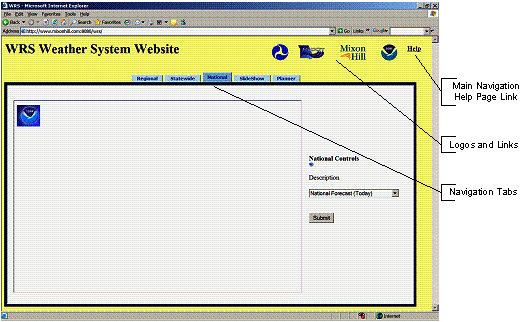
Figure 1 - Initial WRS Home Page
3.1.2 National Weather Maps Module
The National Weather Maps module is the simplest of the modules and was the default module for the initial WRS development. This module consists of a single "Description" drop-down box. This box contains a list of national weather maps from which a selection can be made. The available weather maps allow for selection from the following:
- National forecast (today);
- Precipitation forecast (today);
- Precipitation forecast (tomorrow);
- Precipitation forecast (3-day);
- 24-hour maximum temperature;
- 24-minimum temperature;
- 3-hour air temperature;
- 3-hour dewpoint temperature;
- 3-hour wind speed and direction;
- 3-hour sky cover;
- 3-hour weather conditions;
- 12-hour probability of precipitation;
- 6-hour precipitation amount;
- 6-hour snow amount;
- Current satellite visible;
- Current satellite infrared; and
- Current satellite water vapor.
In the National Weather Maps module, users do not select a geographic location because each map covers the entire continental United States. Figure 2 provides a screen shot of one selection from the National Weather Maps module in the initial WRS deployment.
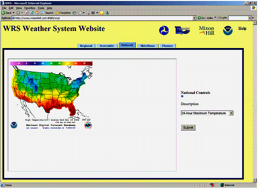
Figure 2 - Initial National Weather Maps Page
3.1.3 Statewide Weather Maps Module
The Statewide Weather Maps module in the initial WRS deployment was designed to provide a view of individual states. The Statewide Weather Maps module provides similar weather map options to the National Weather Maps module, but, in addition, the user can select a "Primary State" from a second drop-down box. Figure 3 provides a screen shot of the Statewide Weather Map module used in the initial WRS deployment.
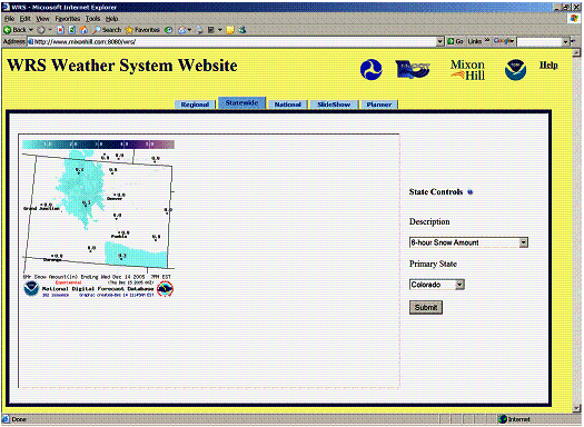
Figure 3 - Initial Statewide Weather Maps Module
3.1.4 Regional Weather Maps Module
The Regional Weather Maps module provided a more detailed view of selected regions in and around the state of Missouri. The Regional Weather Maps cover a smaller geographic area than the Statewide Weather Maps, but show additional information such as county boundaries and principal cities. In common with the National and Statewide Weather Maps modules, the Regional Weather Maps module has a "Description" drop-down box from which the user can select appropriate types of weather map. This module also includes a "Primary Region" drop-down box, from which the user selects the region for which the weather map is displayed. Figure 4 is a screen shot of the Regional Weather Maps module in the initial WRS deployment.
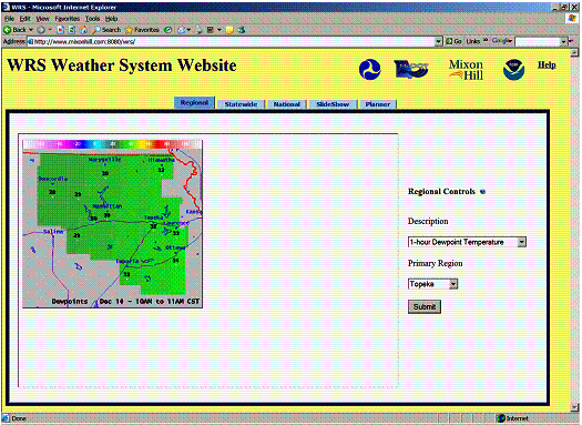
Figure 4 - Initial Regional Weather Maps Module
3.1.5 Slideshow Module
In the initial WRS deployment, the Slideshow module allowed users to select the order in which specified types of weather information would be displayed. The Slideshow module was designed so that users could view a series of weather maps in the specified order, with each map being displayed for up to 60 seconds. The slideshow controls allowed the user to select from Regional, Statewide and National weather map views.
A user interface identifies each of the weather map levels (National, Statewide, and Regional) and for each level lists the specific weather maps available. Users can select any combination of views from the three map levels and available weather maps, and can define the order in which the views were presented and the duration of each view. These views are then presented in a continuous slideshow-style loop. The user interface also provides the ability to specify both a primary and optional location for the Regional and Statewide views. If both a primary location and an optional location are selected, the appropriate weather maps for both locations will be displayed to the user side-by-side in the slideshow. If no primary location is selected, the default location will be used in its place. Figure 5 provides a screen shot of the Slideshow Settings interface in the initial WRS deployment, while Figure 6 provides a screen shot of a single view from a Slideshow Presentation.
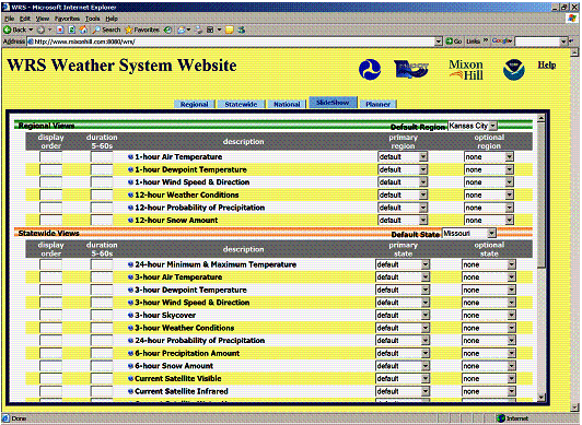
Figure 5 - Initial SlideShow Settings Interface
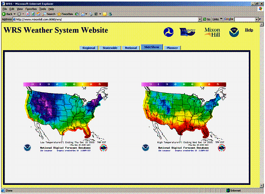
Figure 6 - View from Initial Slideshow Presentation
3.1.6 Maintenance Planner Module
The Maintenance Planner in the initial WRS deployment allowed a user to select thresholds or ranges for various weather conditions, and to see the likelihood of these thresholds being met over the following six to seven days. The user could make selections from six different weather conditions:
- Temperature - minimum to maximum in degrees Fahrenheit;
- Humidity - minimum to maximum percentage of humidity;
- Sky cover - minimum to maximum percentage of sky cover;
- Chance of precipitation - minimum to maximum percentage chance of precipitation;
- Wind speed - minimum to maximum wind speed in miles per hour;
- Wind direction - direction of the prevailing wind.
Users can also select a location of interest by double clicking on a Google® map. Figure 7 provides a screen shot of the Maintenance Planner module in the initial WRS deployment.
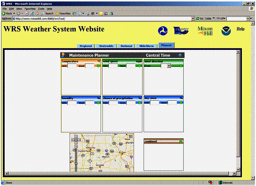
Figure 7 - Initial Maintenance Planner Module
3.2 Enhancements
A series of modifications and enhancements were made to the initial WRS system deployment. These are described in the following sections.
3.2.1 Federal Highway Administration Review
A review of the initial WRS was held with FHWA personnel on December 22, 2005. A number of potential enhancements to the initial system were identified, namely:
- Modify the frame that appears on each page of the WRS;
- Create a new home page for the WRS with a description of the system;
- Provide additional graphical tools within the maintenance planner; and
- Modify the maintenance planner.
The following section describes the changes that were implemented at the time.
3.2.1.1 Changes to WRS Frame and Main Navigation Tools
The following changes were made to the WRS frame and main system navigation tools:
- The title on the frame was changed from "WRS Weather System Website" to "Weather Response System Prototype." The title was created as a clickable link to the new home page (see description in Section 3.2.1.2 below). Additional information was added below the title indicating that system development was jointly sponsored by FHWA and MoDOT;
- The tabs that provide navigation through the system were changed as follows:
- A new tab was added called "Home." This provides access to a new home page (see description in Section 3.2.1.2 below);
- The tab called "Regional" was renamed "Local;"
- The tab called "SlideShow" was renamed "MapShow;"
- A new tab called "Graph" was added (see description in Section 3.2.1.3 below).
Figure 8 illustrates the frame and navigation toolbar before and after these changes.
BEFORE
AFTER
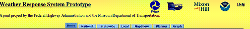
Figure 8 - Changes to WRS Frame and Navigation Toolbar
3.2.1.2 Created New Home Page
A new home page was added to the system. This page became the default page and provided the user with a description of the initial system and some contact information upon first visiting the site. Figure 9 provides a screenshot of the new WRS home page within the new frame described in Section 3.2.1.1.
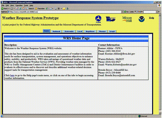
Figure 9 - New WRS Home Page
3.2.1.3 Created a New Graph Module
The Graph module was implemented to show the information entered by the user in the planner module in a graphical format. Each weather condition for which the user has entered values is displayed as a row in the graphic. Each row then shows the date and time ranges during which the user-entered values will be met as a red bar. The red bars on the graphic are updated with new ranges when the user changes values through the Planner module. Figure 10 provides an illustration of a graph populated with data the user has entered via the Planner module.
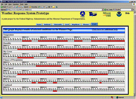
Figure 10 - Populated Graph Module
3.2.1.4 Changes to the Planner Module
The Planner module underwent a number of changes that affected both its functionality and appearance. These comprised the following:
- The overall layout of the Planner was modified so that it could be displayed on a single screen without any scrolling by the user;
- Latitude and longitude are displayed on the screen for the location selected by the user. The user could continue to select locations by double clicking on the map, or could now enter specific latitude/longitude values in the boxes;
- A "Restore Lat/Long" button was added, which returns the latitude and longitude values to the default location;
- Individual "Clear" buttons were added to the data entry sections for each of the available weather types. Clicking this button would clear the user-entered values in that section;
- A "Clear All" button was added that would delete all user-entered data on the Planner page.
Figure 11 illustrates the changes made to the Planner module.
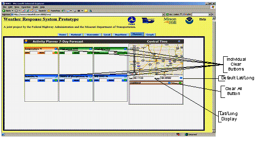
Figure 11 - Changes to the Planner Module
3.2.2 Missouri Department of Transportation Training
During the training session on the initial WRS conducted with MoDOT personnel on January 13, 2006, a series of recommended improvements were identified, as follows:
- Add e-mail links to the contacts identified on the home page;
- Add a Radar module covering the entire United States;
- Add a "Pause and Play" feature to the MapShow module;
- Add a "Clear All" button to the MapShow module; and
- Save the MapShow module settings for 7 days.
The following changes were made at the time.
3.2.2.1 Added Email Links
The project contacts listed on the new WRS home page were provided with e-mail links. Users could click on the e-mail address to open their local email client with a blank message automatically addressed to the contact.
3.2.2.2 Added a Radar Module
The Radar module consists of two separate display pages. The first is a radar home page which provides a map of the United States. Each radar station is marked on this map with a blue dot. Clicking on a radar station takes the user to a radar display page where the corresponding radar images are shown.
The radar display page provides a set of user controls. Users select or deselect various layers of the image, such as the topography, warnings, legend, highways, counties, cities, rivers, and the radar image itself. The speed at which the radar image moves across the display can be increased or decreased using a control on the page; or the image can be stopped and started at any time using other control buttons on the display page. Figure 12 illustrates the Radar home page, while Figure 13 shows an example of the Radar display for the Kansas City region.
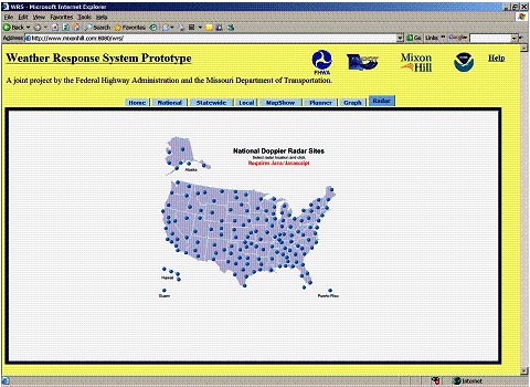
Figure 12 - Radar Module Home Page
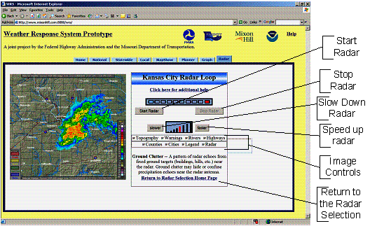
Figure 13 - Radar Module Display Page
3.2.2.3 Changes made to the MapShow Module
Based on recommendations, additional features were provided to the MapShow module. Cookies were used to keep track of user settings for a period of up to seven days. A "Clear Values" button was also added to the MapShow settings page that allows users to reset all data with the click of one button. Figure 14 shows the new "Clear Values" button.
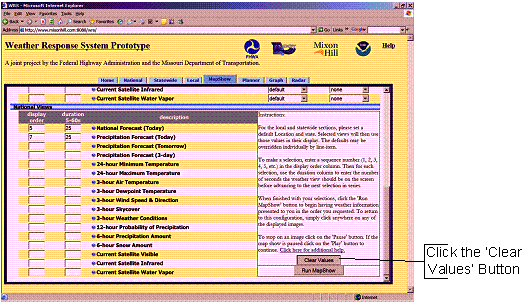
Figure 14 - "Clear Values" Button in MapShow
"Pause" and "Play" buttons were added below each map on the MapShow presentation page. This provides users the ability to stop and start the slideshow as needed. Also, a title was added to each map that states the type of weather condition that is being displayed at that point in time. Figure 15 shows the updated MapShow presentation page.
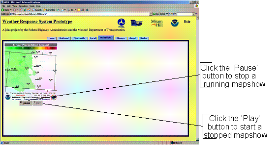
Figure 15 - Example of an Updated MapShow Presentation Page
3.2.3 Presentations to NOAA and MoDOT Personnel
NOAA personnel received a demonstration of the initial WRS deployment during the NOAA Central Region Managers Meeting on March 8, 2006. Subsequently, on March 16, 2006, a demonstration was provided to MoDOT maintenance and customer service personnel. Participants suggested a number of enhancements that could be made to the initial system.
- Make the system easier to read on lower resolution screens;
- Add an enlarged map view and the ability to place markers; and
- Add a 7-day forecast.
This section describes the changes that were made to the initial system after receiving the feedback. The recommendation to add a 7-day forecast could not be accommodated under current time and budget constraints.
3.2.3.1 Changes to WRS Navigation and Overall Presentation
The WRS navigation system and overall presentation of the pages was changed. At lower screen resolutions (e.g., 600 x 800), the frames within which the WRS information was displayed, took up too much space and added unnecessary scroll bars to the screen. Users were becoming confused if all the information could not be seen at once on the screen.
To make these changes, the index.html default page was eliminated and iFrames were no longer used. Instead, each page was given a navigation tab strip and a header bar in which the system title and other related information was presented. Figure 16 illustrates the overall presentation and navigation toolbar before and after the changes were made.
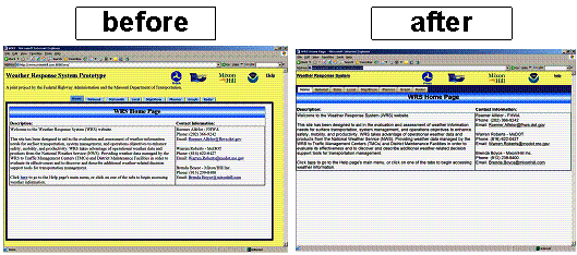
Figure 16 - WRS Presentation and Navigation
Figure 17 provides a before and after picture of the overall WRS presentation and navigation toolbar when used with a 600 x 800 screen resolution. This change eliminated unnecessary scroll bars.
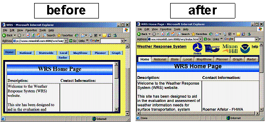
Figure 17 - WRS 600 x 800 Screen Views
3.2.3.2 Add a Larger Map View to the Planner Module
Within the Planner module, a "View Large Map" button was added below the existing map. Clicking this button opens a larger map in a pop-up window. The new map is centered on the same location and is shown at the same scale and zoom level as the existing map in the Planner window, but covers a larger area. The map in the pop-up window is a printer-friendly version. The enlarged map in the pop-up window does not affect any functionality of the Planner module.
Figure 18 illustrates the new "View Large Map" button and the pop-up map.
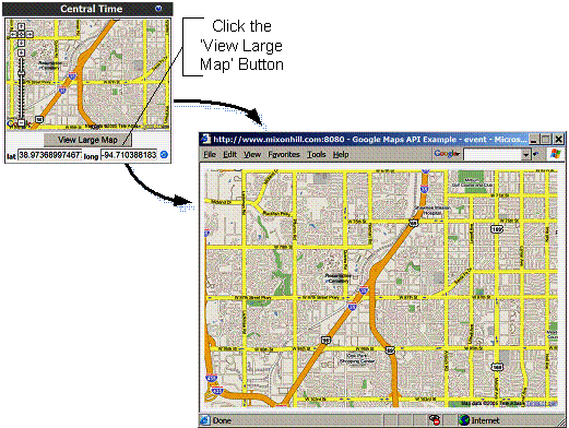
Figure 18 - "View Large Map" Button and Pop-Up Map