Printable Version [PDF 2MB]
To view PDF files, you need the Adobe Acrobat Reader.
Contact Information: Operations Feedback at OperationsFeedback@dot.gov
Publication Number: FHWA-HOP-07-115
Real-time Traveler Information Services Business Models: State of the Practice Review
Prepared for:
Office of Operations
Federal Highway Administration
U.S. Department of Transportation
Washington, DC 20590
Prepared by:
Kimley-Horn and Associates, Inc.
in association with
Cambridge Systematics
FHWA-HOP-07-115
May 2007
QUALITY ASSURANCE STATEMENT
The U.S. Department of Transportation (“the Department”) provides high-quality information to serve Government, industry and the public in a manner that promotes public understanding. Standards and policies are used to ensure and maximize the quality, objectivity, utility, and integrity of its information. The Department periodically reviews quality issues and adjusts its programs and processes to ensure continuous quality improvements.
Technical Report Documentation Page
|
1. Report No. FHWA-HOP-07-115 |
2. Government Accession No. |
3. Recipient's Catalog No. |
||||
|
4. Title and Subtitle Real-Time Traveler Information Services Business Models: State of the Practice Review |
5. Report Date May 2007 |
|||||
|
6. Performing Organization Code |
||||||
|
7. Author(s) Lisa Burgess, Alan Toppen, Pierre Pretorius (Kimley-Horn and Associates, Inc.) |
8. Performing Organization Report No. |
|||||
|
9. Performing Organization Name and Address Kimley-Horn and Associates, Inc. 7878 N. 16th Street, Suite 300 Phoenix, Arizona 85020 (performed as a subconsultant to Cambridge Systematics) |
10. Work Unit No. (TRAIS) |
|||||
|
11. Contract or Grant No. DTFH61-06-D-00004 |
||||||
|
12. Sponsoring Agency Name and Address Office of Operations Federal Highway Administration 1200 New Jersey Avenue, S.E. Washington, DC 20590 |
13. Type of Report and Period Covered |
|||||
|
14. Sponsoring Agency Code HOTM |
||||||
|
15. Supplementary Notes FHWA COTM: Robert Rupert |
||||||
|
16. Abstract
This State of the Practice Review documents a range of business models for real-time traveler information services, and provides ‘real world’ examples of how States and regions are developing partnerships and business plans within the business model frameworks. Although there are numerous variations on these models, there is no question that there have been shifts in the fundamentals of these traditional business models, as well as new business model structures that have emerged. Included with this review is a summary of current prevalent business models, which include public-sector funded, franchise operations, private sector funded and business-to-business models. It addresses issues such as roles and responsibilities within the models, pros and cons of the various approaches, and provides case study examples of traveler information programs throughout the country.
This document also discusses the trends and impacts that have influenced current traveler information business model approaches, including the impact of 511 on the role of the public sector, trends in data collection and the new role of the private sector as data collector, and some of the resulting data ownership issues. With the prevalence of Web-based, business-to-business and supply-chain information bundling, there are increasing opportunities for private sector to be able to generate revenue either through subscription services or advertising. |
||||||
|
17. Key Word Traveler Information, 511, Business Models, Information Dissemination, Data Collection, Public-Private Partnerships, Business Planning |
18. Distribution Statement No restrictions |
|||||
|
19. Security Classif. (of this report) Unclassified |
20. Security Classif. (of this page) Unclassified |
21. No. of Pages |
22. Price |
|||
Form DOT F 1700.7 (8-72) Reproduction of completed page authorized
Table of Contents
Section 1. Introduction and Project Overview
1.1 Context for the 2007 State of the Practice Review
1.2 Summary of Contributing Factors to Changes in Traveler Information Business Model Approaches
Section 2. Background and Historical Context
2.1 Early Traveler Information System Business Model Approaches
2.2 Lessons and Experiences from European Models
2.3 National Guidance Promotes Quality, Consistency in Traveler Information Services
Section 3. Predominant Traveler Information Business Models and Issues
3.1.1 Public Centered Operations
3.3 Private-sector operated and funded models
3.3.1 Private sector operations without funding from the public sector
3.3.2 Free services supported by advertising
3.3.4 Free basic information with premium services available for a fee
3.4 Value-added reseller models
3.5 Business-to-business models
Section 4. Business Model Trends and Impacts
4.1 Expanded roles for the public sector
4.1.1 Growth and impacts of 511
4.1.2 More than a Weekday Commute Tool
4.1.3 The public sector as data aggregator
4.1.4 Enhanced and Personalized Information Available from the Public Sector
4.2.1 Trends in Sensor Data Collection
4.2.2 Trends in Probe Vehicle Data Collection
4.2.3 Transit Information Services
4.3 Strategies and Challenges for Expanding the Public Sector Traveler Information Programs
4.4 Traveler Information Services Policy Issues for the Public Sector
4.4.1 Responses to Emerging Private Sector Business Models
4.4.3 Traveler Information Services Data Quality
4.4.4 Summary of Policy Issues and Considerations
4.5 Other Private Sector Trends
Appendix A – References and Resources
Appendix B – Web Survey Questions
List of Acronyms
AAA – American Automobile Association
AASHTO – American Association of State Highway and Transportation Officials
ADOT – Arizona Department of Transportation
ATIS – Advanced Traveler Information Services
ATMS – Advanced Traffic Management System
CAD – Computer Aided Dispatch
CARS – Conditions Acquisition Reporting System
DMS – Dynamic Message Sign
DOT – Department of Transportation
EMS – Emergency Medical Services
FDOT – Florida Department of Transportation
FHWA – Federal Highway Administration
GPS – Global Positioning Satellite
HTCRS – Highway Travel Conditions Reporting System
ISP – Information Service Provider
ITIP – Intelligent Transportation Infrastructure Program
ITS – Intelligent Transportation Systems
IVR – Interactive Voice Response
KDOT – Kansas Department of Transportation
MDI – Model Deployment Initiative
MDOT – Michigan Department of Transportation
MoDOT – Missouri Department of Transportation
MTC – Metropolitan Transportation Commission
NJDOT – New Jersey Department of Transportation
ODOT – Oregon Department of Transportation
PDA – Personal Digital Assistants
PND – Personal Navigation Devices
RDS-TMC – Radio Delivery Service -Traffic Message Channel
SAFETEA-LU – Safe, Accountable, Flexible, Efficient Transportation Equity Act: A Legacy for Users
SANDAG – San Diego Association of Governments
TTI – Traffic and Travel Information
UDOT – Utah Department of Transportation
VAR – Value-Added Resellers
VDOT – Virginia Department of Transportation
WAP – Wireless Application Protocol
Executive Summary
Partnerships for traveler information systems and services have been in various stages of evolution, cooperation, and functionality. Traditional public-private partnerships for traveler information have typically consisted of public agencies serving in a data collection role (through manual and automated systems) and making use of data collection infrastructure and systems that were initially designed for traffic management and operations purposes.
This State of the Practice Review documents a range of business models for real-time traveler information services, and provides ‘real world’ examples of how States and regions are developing partnerships and business plans within the business model frameworks. Although there are numerous variations on the more traditional models, there is no question that there have been shifts in the fundamentals of these traditional business models, as well as new business model structures that have emerged.
Key shifts in both the public sector arena as well as the private sector marketplace are evident in the current business models and partnerships for traveler information services. On the public sector side, the most notable shifts have come about largely due to the increasing role of public sector for traveler information. 511 phone and Web services, largely spearheaded by public sector, have put a very recognizable brand on traveler information. Furthermore, as public sector system operations become more integrated, traveler information is no longer a stand-alone function. Closely linked are operations, maintenance, incident management, public transportation, weather monitoring and multi-agency coordination—all of which have strong ties to traveler information—and the public sector is looking for creative ways to leverage its investments. Public agencies are taking on more responsibility for aggregating data to support systems that provide more robust and comprehensive information to travelers. Several public sector agencies are also developing innovative applications to deliver personalized and enhanced information to travelers, either through Web-based resources or through ‘push’ technologies, such as alerts delivered to mobile phones. This is an area that was once thought to be under the private sector commercial services umbrella.
Roles for private sector are also shifting. Early traveler information models focused heavily on the private sector leading efforts for data fusion and dissemination. While these may still be the case, there is increased activity on the private sector side for data collection, including infrastructure-based, probe vehicle data, and aggregated, multi-source data. In an effort to be able to expand upon what is currently available from public sector data collection infrastructure, the private sector is looking at innovative ways to obtain data over broader geographic areas. This shift has turned the public sector into a potential consumer for private sector data. It has also put an important responsibility on the public sector to be able to safeguard commercial value of private sector data and services. Some of the most successful private sector models are ones that have multiple levels of revenue potential; in other words, there is a need for the private sector to look at the range of potential consumers—the public, other private sector companies, as well as the public sector.
The private sector continues to pursue good models, and there is continued interest in subscription services, as evidenced by the growing number of partnerships to combine real-time traffic data with navigation applications, either mobile or in-dash units. Subscription models are not without their challenges, and despite growing interest in personalized mobile applications, there is still a need to balance the threshold of what consumers are willing to pay for traffic information. Media continues to be a powerful private sector partner for traveler information, and with media comes a range of potential business model options and business-to-business partnering opportunities.
From a regional traveler information program perspective, the most sustaining model is one that has significant resources, leadership and investment from the public sector. Whether public-sector operated or through contracted operations with the private sector, the need for public sector financial resources for traveler information is not diminishing.
Traveler information business model approaches developed over the last decade saw very clear roles for the public and private sector in terms of data collection, data aggregation, data fusion, information dissemination, and key steps in the process where private sector would be able to monetize their product or services. With the evolution of technology, raised awareness of traveler information among the public, creative partnering approaches from both the public and private sides, and a strong push toward broader coverage of traveler information programs and enhanced accessibility for users, there have been distinct shifts in these roles. This State of the Practice Review documents many of these shifts and provides an overview of current trends and issues with traveler information business models.
Section 1. Introduction and Project Overview
1.1 Context for the 2007 State of the Practice Review
For more than a decade, partnerships for traveler information systems and services have been in various stages of evolution, cooperation, and functionality. Traditional public-private partnerships for traveler information have typically consisted of public agencies serving in a data collection role (through manual and automated systems) and making use of data collection infrastructure and systems that were initially designed for traffic management and operations purposes. Recognizing that this operations data could support a key service in providing road and travel conditions information to motorists and travelers, the public sector made additional investments in ‘push’ technologies and infrastructure to disseminate information via dynamic message signs (DMS), highway advisory radio and other means. Data gathered by the public sector was often provided to the private sector Information Service Providers (ISP) who would then disseminate information through a variety of systems, such as media traffic reports or through personal wireless and in-vehicle technologies.
Business models for traveler information have also been evolving to keep pace with technology advances, stronger focus by the public sector on integrated operations and customer service, as well as with the increased consumer demand for more comprehensive and real-time information.
Federal Highway Administration (FHWA) is spearheading the development of an update to the Advanced Traveler Information System (ATIS) Business Models review prepared in 2001 to capture some of the shifts and changes in traveler information business partnerships, identify which models have had the greatest success in terms of sustainability, and where there are innovative or unique models in place or on the horizon.
This State of the Practice Review takes a look at typical business models for real-time traveler information, and provides ‘real world’ examples of how States and regions are developing partnerships and business plans within these model frameworks. These frameworks were developed as part of previous efforts to begin to establish some guidelines and scenarios for how partnerships could be structured to support traveler information services. Although there are numerous variations on the more traditional models, there is no question that there have been shifts in the fundamentals of these traditional business models, as well as new business model structures that have emerged.
1.2 Summary of Contributing Factors to Changes in Traveler Information Business Model Approaches
A significant emphasis of this State of the Practice Review is to document the major influences and shifts that are occurring in business model arrangements for traveler information. One of the biggest influences in recent years, at least on the public sector side, has been the emergence of 511. With 511 phone and Web-based traveler information systems, there has been a noticeable surge in the public sector ownership and responsibility for traveler information, and for developing innovative fusion and dissemination strategies that were once thought to be under the private sector umbrella. In many areas, 511 has become synonymous with a regional or statewide traveler information program, and there are several references throughout this document that highlight innovative program aspects from a wide range of systems and regions.
At the national level, the Safe, Accountable, Flexible, Efficient Transportation Equity Act: A Legacy for Users (SAFETEA-LU) Section 1201 requirements as part of the recent federal transportation legislation are seen as a key driving force behind several public-sector initiatives, a key one being traveler information. There are efforts underway to be establishing a national ‘standard’ for data attributes relative to timeliness and time parameters for incidents, delay, and other key traveler information services components. These have implications that go much deeper than what information the user receives—they will require changes to how data is collected, by who, influence the aggregation/fusion process, and will have obvious impacts in terms of data sharing.
The impact of technology and advances in information collection and delivery mechanisms cannot be underestimated. From advances in data collection and the emergence of the private sector data collection options in recent years, to the widespread use of Internet and wireless mobile applications, supply and consumer demand are at historic highs. Conversely, the private sector is still trying to pinpoint where the consumer threshold is for a marketable, profitable subscription-based product. Many of the private sector organizations interviewed as part of this State of the Practice Review articulated that private enterprise is also looking for good models.
Furthermore, the private sector is not just marketing directly to the end user consumer. In fact, the public sector is also a potential consumer base for private enterprise. Supply chain theories apply to traveler information as well, and many of the products and services we use for traveler information on mobile phones, in-vehicle devices or even Web sites require several layers of partners to deliver. The business-to-business relationships are evolving along with the potential business models.
1.3 Methodology and Approach
The study team relied heavily on input from both the public and private sectors to be able to capture the current approaches and issues with business models and business model arrangements for traveler information. Three key methods were used to obtain information and real-world experiences:
-
Literature review of available documentation, including traveler information business plans, strategic plans and program descriptions. Also included with the literature review were previously developed documents that focused on traveler information business models, data quality and data reporting systems. Agency Web sites and performance monitoring plans were also reviewed. A list of resources and literature obtained during the course of this study is included in Appendix A.
-
Web-based survey. In December 2006, a Web-based survey was distributed to the public sector traveler information contacts in an effort to obtain a wide cross-section of input about their traveler information program partnerships, involvement of the private sector, data sharing arrangements, and innovative approaches. A list of the questions that were included in the Web survey is included in Appendix B.
-
Interviews. Phone and in-person interviews were conducted with several representatives from the public sector and the private sector regarding traveler information services. These included regional and statewide traveler information systems operated by the public sector, as well as a wide range of companies from the private sector representing data collection, dissemination, and system operators/developers.
Section 2. Background and Historical Context
2.1 Early Traveler Information System Business Model Approaches
The basis for many of the past and current traveler information business models and business partnering approaches was a two-part series from ITS America, “Business Models for Advanced Traveler Information Systems Deployment” (1997) and “Choosing the Route to Traveler Information Systems Deployment: Decision Factors for Creating Public-Private Business Plans” (1998). These guidance documents provided a succinct overview of some of the key policy, partnering, planning and system development issues that the public sector could expect to encounter (or at least consider) as it moved toward a more business-based approach to traveler information systems. The ‘big five’ business model arrangements, shown below in Table 1, described roles and responsibilities for various partners under the different partnering arrangements, but were general enough to accommodate variations.
Table 1 – Early Traveler Information Business Model Frameworks
|
Public-Centered Operations |
|
Least Risk
Least Potential for Revenue
Higher Risk
Higher Potential for Revenue |
||||||
|
Contracted Operations |
|
|||||||
|
Contracted Fusion with Asset Management |
|
|||||||
|
Franchise Operations |
|
|||||||
|
Private, Competitive Operations |
|
|||||||
When these model approaches were developed in 1998, there was a distinct emphasis on urban area, regional traveler information services. These were the areas that were likely to have data available from the public sector, as well as a target market of commuters that would find value in accurate, timely, and relevant information about road and travel conditions.
The challenge almost a decade ago was that there was limited case study material available. Many regional traveler information programs and systems were just emerging, as were the various partnerships among the public and the private sector. The private sector marketplace was also somewhat emerging, and as demonstrated by the above models, relied on a ‘traditional’ relationship of the public sector collecting data, and the private sector having the technology, resources and interest in performing the data fusion and dissemination functions. There were very few proven success stories in terms of business models and business arrangements, largely due to the maturity level of the traveler information service marketplace. Technology and applications were emerging at a fast pace, and with them came a plethora of ‘potentials’. Many of the early implementations as part of the Metropolitan Model Deployment Initiatives (MDIs) and other traveler information services were quite experimental, from technology, consumer acceptance, and longevity standpoints. Widespread usage of the Internet and wireless technology had not yet emerged as a market focus area. As a result, initial costs and risks for technology applications and demonstrations were high, which impacted the public sector as well as the private sector. Media (television and radio) was viewed as a strong partner on the private side, and there was often a direct relationship between DOT and media for information dissemination.
A 2001 report titled “ATIS U.S. Business Models Review” documented how the market and business models were actually developing, and took a critical look at 10 regional markets. Some of the key conclusions and findings based on discussions from the public sector and the private sector perspectives included:
-
The public sector support is essential to successful traveler information service implementation. Successful, sustaining systems have significant involvement from the public sector in data collection as well as fusion.
-
Models that relied on the private sector generating revenue to offset public costs or sustain operations of a regional traveler information service had not proved successful.
-
Customer threshold and willingness to pay for traveler information was not yet proven.
2.2 Lessons and Experiences from European Models
Although the focus of this State of the Practice Review is on traveler information service business models in the United States, there are some benefits to looking beyond the domestic models and approaches for lessons, practices and policy issues from European approaches that could potentially be applied here.
A 2002 scanning tour comprised of FHWA, American Association of State Highway and Transportation Officials (AASHTO), Federal Transit Authority, State DOTs and the private sector toured eight European cities with established, multimodal traveler information programs. From a business model and partnering perspective, there were some key similarities in terms of policies and approaches. Both European and US practices recognize that a sustainable traveler information system requires multi-agency cooperation to develop, implement, and ultimately deliver for the long-term. In several areas visited there was strong reliance on the public sector for overall traveler information system funding, program management, data collection and information dissemination. There were also very defined roles and contract arrangements. In Berlin, there were some emerging concepts and models for public-private partnering for traveler information that were very similar to approaches used in the United States (the public sector subsidizes initial start up and provides a basic level of information to the public, and the private sector generates revenue for sustaining operations through enhanced, value-added products and services and business-to-business arrangements).
The European Commission has publicly articulated very strong support for partnering among the public and private sector to advance and accelerate deployment of intelligent transportation systems (ITS) and programs, with a distinct emphasis on Traffic and Travel Information (TTI) throughout Europe. A 2001 Commission of the European Communities Report and Recommendation specifically outlined several key directives, which encourage public authorities to:
-
Allow the private sector to deploy and operate their proprietary traffic monitoring equipment on public roads;
-
Adopt measures to ensure that public authorities “safeguard the commercial value” of proprietary traffic data received by private service providers; and
-
Ensure that the private sector TTI service providers have flexibility to develop and distribute travel information products and services on a commercial basis, providing they do not impact safety, traffic management, or jeopardize privacy and personal data.
This policy-level recommendation and provisions for establishing the public/private framework is a bold recognition by the European Commission about the value in public-private partnering for traveler information.
Key differences include the prominence among European systems for multimodal and route-planning applications. Examples include the Berlin Model (www.vmzberlin.de) as well as the United Kingdom’s www.TransportDirect.com. Such robust, multimodal applications require substantially higher investments in data collection, multi-agency coordination and system management and oversight than what is typically found in US-based traveler information tools (although there are exceptions). This level of data collection and coordination also points to a significant investment from the public sector for the up-front activities and operations, which is not unlike how most business model approaches in the US currently operate.
2.3 National Guidance Promotes Quality, Consistency in Traveler Information Services
One of the keys to defining and developing good business models is to have a clear foundation of system capabilities, expectations, and performance standards. As systems throughout the country have evolved, become more technology focused and integrated, and with an increased focus on bringing multiple data sources together to support a comprehensive program, defining quality and consistency expectations has become increasingly important, and is an area where there has been national leadership from FHWA, AASHTO, ITS America, and others.
“Closing the Data Gap: Guidelines for Quality Advanced Traveler Information System Data” began articulating some of the critical features, attributes and quality parameters that should be factored in to traveler information services. Attributes include such characteristics as timeliness, accuracy, cost (to use) and reliability were identified as important factors for users. These guidelines also outlined some very definable and measurable parameters for various data types, which put some very specific attributes to the myriad of data that could be incorporated into a real-time traveler information system. Attributes such as accuracy, detail, breadth of coverage and others provided at least a baseline for establishing what could constitute ‘quality’ data—a definite benefit for either public or private interests. What this provides to the business model and developing the partnerships within the model is a common framework for how to articulate system expectations.
When the 511 Coalition published its national guidelines, the intent was to promote some consistency among the individual systems that were being implemented throughout the country. What began as a means of providing guidance on what should constitute ‘basic’ and ‘enhanced’ content for 511 has evolved into a tool for deployers to use to address nearly all facets of system deployment, operations and marketing. Potential business models for 511 services were also developed, and were somewhat based on the ‘big five’ traveler information business models developed in the 1990’s, but were modified to address the service-specific nature of 511 phone traveler information services. These included:
-
Public sector funded;
-
Subscription model;
-
Pay-per-call model (conflicts with Coalition guideline of no more than the cost of a local call);
-
Advertising and sponsorship model;
-
Loss-Leader/Franchise model; and
-
Hybrid model, to allow a combination of approaches.
The guidelines and the potential 511 business model approaches developed in the early years of 511 implementation were geared toward the phone component, and did not really factor in the traveler information Web site. The intent was to provide deployers with options for flexibility in how they structured a (potential) cost recovery mechanism and partnerships as part of 511. To date, the model for nearly every 511 program in operation is the public sector funded. It should be noted that there are some emerging regional 511 services offered through the private sector; however, these services also follow the guiding principle of ‘no more than the cost of a local call’ for users. The prevailing theme, which has been echoed across numerous traveler information business models, is that the most successful and sustaining are those with significant support and resources from the public sector.
Section 3. Predominant Traveler Information Business Models and Issues
This section illustrates the typical traveler information business model structures, and presents case studies of how regions and agencies have developed traveler information programs within a business model environment. Included is discussion about the fundamental structure of business models, as well as some variations, and ‘real-world’ examples of how these business models are currently working. Issues and challenges that are inherent in the business model approaches also are presented.
3.1 Public Sector-Funded
To date, this is still the most sustaining and successful model for delivery of regional traveler information. The term ‘regional’ is no longer limited to urbanized areas; traveler information programs a decade or more ago focused primarily on data-rich urban environments. With the emergence of 511 and with strong leadership from the public sector to provide traveler information on a statewide level, the focus of traveler information has also broadened in scope for many areas. State DOTs are making significant investments in data collection and reporting systems, establishing partnerships for additional data (such as with public safety for incident information), as well as investing in phone and Web-based dissemination tools, which were once thought to be primarily a responsibility of the private sector.
The public sector operated/funded model generally falls into two categories which rely heavily—if not solely—on funding from the public sector for key operational areas of their traveler information programs. Table 2 provides a comparison of these two approaches to the public sector funded model.
Table 2 – Comparison of the Public Sector Funded Approaches
|
Public Centered Operations |
Contracted Operations |
||||||||
|
|
||||||||
|
Examples: AZTech™, Phoenix, AZ Kansas DOT (Statewide) Oregon DOT TripCheck |
Examples: MTC, San Francisco Bay Area, CA Tampa Bay Area, FL (511 service) Florida DOT Statewide (iFlorida) |
||||||||
While this model requires a substantial amount of funding, leadership and involvement from the public sector, there comes with that a certain level of ‘control’ over the traveler information program. With public funds and contracting mechanisms in place, the public sector can be very specific about data, quality and performance expectations. There is also a certain amount of longevity and sustainability that comes with the public sector leadership and ownership.
75% of the agencies surveyed for this Review stated that involvement from the private sector has not diminished the public sector responsibility for their traveler information programs.
Another advantage of this model is that there is flexibility to be able to tap specific expertise from one or more partners from the private sector to address certain pieces of the traveler information program—such as expanding data coverage by supplementing with the private sector data, or perhaps contracting with a private sector provider to operate a key dissemination outlet (such as phone, Web or both). Kansas DOT (KDOT) indicated that as part of their traveler information program strategic planning process, they took a hard look at what they really wanted to provide to the public, identified what the department could realistically accomplish, and where it made sense to contract with a private partner for additional expertise and resources. The result is a strong KDOT-led statewide traveler information program that utilizes a private contractor for 511 operations (Meridian), and partnerships with a wireless telecommunications provider for kiosks.
3.1.1 Public Centered Operations
There are several solid examples of the public centered operations model, including both regional as well as statewide systems. These successful models include varying levels of involvement from the private sector, but they are not dependent on the private sector in a substantial operational role to where the traveler information program could not operate without their involvement. The AZTech™ program in the Phoenix metropolitan area of Arizona, and Oregon DOT’s TripCheck are featured below.
Arizona – AZTech™ Case Study
AZTech™’s traveler information business model has been evolving since 1996, when the FHWA MDI began in the Phoenix metropolitan area. A key objective of the MDI was to showcase innovative public/private partnerships for traveler information delivery. AZTech™ began with a very formal approach to partnering with the private sector, including issuing Requests for Proposals and developing formal contractual agreements with each of the partners. Between 1996 and 2005, AZTech™ went through three private partner phases. A key principal for each phase was that it would involve multiple non-exclusive arrangements – the AZTech™ partners did not want to limit or constrain their ability to capitalize on innovations from the private sector. Data would be made available to multiple private interests whereas early phases of the AZTech™ program required a contract to access data. This allowed the Arizona DOT (ADOT) and other partners to know who was accessing their information. With many more interests now wanting data, ADOT made the decision to do away with contract agreements for the private sector to access ADOT’s data feed, and instead make the data available via a file transfer protocol (FTP) site (registration required).
AZTech™’s first two phases saw a wide array of involvement from the private sector, which was focused primarily on disseminating traveler information. Kiosks, wireless application protocol (WAP) phones, handheld devices, in-vehicle devices and other technology applications that were part of the early AZTech™ MDI program eventually went by the wayside. These new technologies with limited deployment, limited regional focus, and business models that relied primarily on subscription services did not result in successful, sustaining deployments. The public sector data collection infrastructure was also limited during the early MDI phases, and consisted primarily of freeway sensor data on two freeway corridors. According to AZTech™, there is definitely some risk for early implementers. The public sector efforts were not necessarily impacted by the private sector turnover – AZTech™ public partners continued to focus on data collection and dissemination through the traditional public channels (media partnerships, roadside infrastructure, etc.).
Data collection has been primarily a public-sector responsibility for the AZTech™ traveler information program, and AZTech™ partners are continuing to put a strong focus on improving data collection. In recent years, two key partnerships with the State Department of Public Safety and Phoenix Fire (who dispatches for nearly 20 fire/emergency medical services (EMS) response agencies in metropolitan Phoenix) are providing real-time incident data via a computer-aided dispatch (CAD) feed. AZTech™ estimates they now have knowledge of 80% of incidents in the metropolitan area that impact the arterial network; previously, this arterial information was extremely limited. AZTech™ partners have essentially evolved into a data aggregator, and ADOT and the Maricopa County DOT have taken on a large responsibility to consolidate traffic, incident, weather and event data into a robust database that serves the Phoenix and Tucson metropolitan areas as well as statewide corridors. Arizona’s 511 service (phone and Web) is also operated and maintained in-house.
Oregon – TripCheck.com Case Study
TripCheck has become synonymous with traveler information in Oregon. Developed (and currently operated) in house by the Oregon DOT (ODOT), TripCheck was launched in 1998 as a Web-based tool for road conditions, closures, and in particular winter road closure information for Oregon’s statewide highway system. ODOT partnered with the Oregon Travel Information Council (TIC), a “self-funded state agency” which manages the interstate and off-interstate logo sign program. The blue highway signs provide directional information to traveler services (gas, lodging, food, camping and attractions). Through this partnership, ODOT received a percentage of the revenues generated from the logo sign program to help fund TripCheck development and operations activities.
Since the initial launch, ODOT has been incrementally enhancing the TripCheck.com Web site to be able to provide enhanced urban area information (cameras and event information), statewide weather, and traveler services. A substantial upgrade to the system was launched in 2005, and included a major revamp to the Web site, alert information, enhanced functionality and traveler services information. A continued partnership with the TIC facilitates hotels, restaurants, and other businesses to be listed as part of TripCheck.com.
Although ODOT also operates a statewide 511 phone service, and has co-branded 511 with TripCheck. The TripCheck.com Web site was already a well-recognized brand for traveler information in Oregon, and with the implementation of 511 and the transition away from the previous toll-free hotline, ODOT was able to bundle both phone and Web under the TripCheck brand.
3.1.2 Contracted Operations
The other facet of the public-sector led traveler information program is where a private sector entity is contracted to serve in a significant operational role – whether it is to support or lead data collection, information aggregation or information dissemination. For this model, the private sector serves under a termed contract in a fee-for-service arrangement. The public sector still serves in a leadership and operations role, but contracts with the private sector to serve in a specific function.
There are several variations on this model and arrangement, and roles for the private sector will vary depending on the specific needs of the public sector and the niche that private sector can address. Table 3 below broadly identifies potential roles for the private sector to participate in a regional traveler information system as part of a contracted arrangement.
Table 3 – Private Sector Contracted Operations Roles
|
Data Collection |
A surge of data collection companies have entered the market in recent years. Some, such as SpeedInfo, Traffic.com and TriChord, gather data through their own roadside infrastructure, and sell that data to the public sector and other private entities. Emerging technologies, such as cell phone/travel time data collection strategies, are still under development and in the early implementation stages. Section 4.2 provides additional details. |
||||||||||
|
Data Provider (Aggregated) |
Traffic.com and Inrix are two examples of data providers that are also data aggregators – they gather data from a variety of fleet, the public sector, and other sources to provide a data feed with speed/flow (which includes real-time and predictive) as well as incidents. Although the public sector is a source of data to this feed, the expanded data coverage provided by their other sources also makes the public sector a potential consumer. These providers of aggregated data also serve other private sector entities (such as media, in-vehicle navigation system operators, and other ISPs) in the traveler information arena. Their customer base is broad – they can be a resource to both the public and private sectors to support a range of information dissemination methodologies. |
||||||||||
|
Information Dissemination |
Perhaps the most prominent of the public/private partnerships for traveler information is in contracted operations for information delivery. 511 has seen an increase in contracted operations – several private entities are involved with developing and operating 511 Interactive Voice Response (IVR) phone systems. Virginia has a unique arrangement with TrafficLand to coordinate dissemination of Virginia DOT’s (VDOT) video images through Web and broadcast media. |
||||||||||
|
System Development and Operations |
This category would include contracted operations to develop or operate elements of the traveler information system, such as the data fusion engine, a database or reporting system, or other critical element. |
||||||||||
The contracted operations approach has several advantages:
-
The public sector still has a strong role and direction in the program. Even with the private sector supporting some operational aspects, it is still viewed as a public system, and with that comes stronger accountability on the part of the public sector.
-
The public sector can contract with one or more private entities to provide specific services – this provides a level of flexibility, while allowing the public sector to expand or broaden its traveler information services. Contracts/agreements also provide some level of risk management.
-
The public sector leverages the strengths of the private sector in terms of bringing innovative approaches and cost sharing from other cities/States.
Risks with this approach can be minimized through contracts and agreements. These are more prominent in ‘for fee’ services; with zero dollar agreements, there is a risk of less incentive for the private sector. These of course depend on the nature of the services – data and systems provided by the private sector are typically considered a commodity or service to which a monetized value can be attached, as well as performance metrics. If the contractor is not performing, the public sector can take action by enforcing contract terms or getting another contractor. Contracts can also specify quality parameters for data, service, system reliability, and other attributes.
Metropolitan Transportation Commission, San Francisco Bay Area – 511 Contracted Operations Case Study
The Metropolitan Transportation Commission (MTC) in the San Francisco Bay Area uses this model to contract with a system manager/operator for comprehensive operations of their traveler information system. In fact, MTC maintains several subcontracts to support various components of their 511 program (this includes the private sector data collection contracts, Real-Time Transit information system development, marketing). Telvent Farradyne, the primary operations contractor that operates the Traveler Information System, developed the TravInfo database, as well as the IVR system and Web. Telvent Farradyne operates and hosts the system, and is responsible for ongoing operations, enhancements and expansion. Coordination with other contractors and agencies is essential in this role, because MTC’s multimodal system includes traffic conditions information, transit, rideshare, bicycle, and planned event data. Each of these modes utilizes different contractors to support different pieces of the system. Even with significant contractor support, MTC staff is integrally involved in day-to-day operations and management, and has a very strong focus on strategic planning. The Bay Area 511 is undoubtedly the most robust system of its kind; MTC has made a significant investment in this regional system, dedicating approximately $4 million per year.
MTC has stated they prefer long term contracts – there is more continuity, less risk, and longer-term contracts minimize the need to go through a complex procurement process on a regular basis. The trust and synergies developed between contractors and MTC staff cannot be underestimated. Furthermore, longer term contracts lead to better short- and long-term planning. The MTC system has been evolving for a decade, and the ability to strategically plan for enhancements—particularly with such a complex and intertwined system—has been a key to the success and ongoing evolution of this robust program.
Florida – Contracted Program Elements Case Study
Florida DOT (FDOT) contracts out various portions of its ITS program to several private sector firms. As part of the iFlorida consortium, Castle Rock developed and maintains the Statewide Conditions Acquisition Reporting System (CARS), which is the statewide repository of incident, construction and special event information that feeds the Statewide 511 system. They have a contract with PBS&J and Southwest Research Institute to develop and maintain the advanced traffic management system (ATMS) software and data fusion engine, which calculates the travel times from sensor and toll tag data in Orlando. In addition, FDOT has a contract with TMI (Traffic Management, Inc.) to operate its Orlando traffic management center. A firm called Logic Tree has a contract to provide and maintain the platform that runs the 511 phone system. FDOT also contracts out maintenance of field devices.
FDOT sees traveler information services as a public sector responsibility, but recognizes that it must leverage the expertise resident in the private sector to produce a quality product. Each of the firms they contract with has a certain expertise that together provides the complete traveler information service to the public. In the end, however, the public sector has a responsibility to ensure traveler information services are available and the best way to do that is to serve as its own general contractor for all the pieces that need to be in place.
Florida DOT District 7 – Traveler Information Program Case Study
FDOT District 7 (Tampa Bay) contracted out its traveler information services to Traffic.com in 2004. They have a separate contract with Traffic.com through the Intelligent Transportation Infrastructure Program (ITIP), which will be discussed in section 4.2.1. Unlike ITIP, this is a typical contracted operation, awarded out of a competitive selection process. FDOT pays Traffic.com an annual fee to run and maintain the 511 system, and paid an additional first year amount to design and launch the system. The contract has a set expiration date (August 2008), after which time District 7’s 511 system will merge with the statewide system. In addition, District 7 has a new traffic management center that is ramping up operations and will run the Statewide ATMS software. The benefit to contracted operations in this case, is the ability to establish a contract for a specific period of time, after which the agency can adapt to a changing direction, in this case a statewide initiative unifying the Districts under a common traffic management platform.
3.2 Franchise Operations
This model is another representation of a public/private partnership – it relies on the private sector being able to support some or all of its operations for the traveler information system, or at the very least be able to offset the amount of public funds required to operate or deliver traveler information services.
Typically, this business model does provide for some flexibility in how the private sector accomplishes revenue generation – either through capital investors, usage fees (either for the end user or through fees charged to outside entities for use of the data), license fees or advertising. It should be noted that there may be some restrictions on advertising based on public partner policy, particularly if the program is under the guise of a ‘public sector’ system.
On paper, the franchise operations model seems like a viable idea: capitalize on the private sector’s innovation, resources, and ability to keep pace with technology while offsetting or reducing the public sector’s financial or resource obligations to support the system. With an environment that encourages the private sector to be innovative, there is an incentive for the private sector to be creative in how they approach developing their model.
It is important to note that the franchise model does not necessarily diminish the role of the public sector in the overall system development or delivery, but rather would allow the public sector to focus on elements of the operations program that it is already doing, such as operating freeway sensors and gathering that data or providing information to travelers through DMS. The private sector would then take on additional components of the system in an effort to provide a service while being able to generate revenue for its operations.
To date, there are few examples of this model in a sustaining environment. A key challenge that has hindered the success of this model is the fact that most systems that tried to implement it did so on a regional basis. This means that there is a substantial investment required by the private sector to be able to develop and implement systems that focus on a narrow target audience within a region. Generating enough revenue to cover capital as well as operations costs becomes a challenge with a limited potential target audience.
Another challenge is that the majority of opportunities for revenue generation as part of a regional traveler information system are on the dissemination side – whether by charging fees directly to users or by charging access/license fees to other public and private entities for access to data, video or other information. In order to effectively do this, there needs to be some element of exclusivity, otherwise where is the incentive to pay? Many public sector agencies willingly provide data to multiple public and private partners as a means of utilizing various avenues to get the information to consumers. Information is freely available to consumers via radio, television, phone and Internet, which in most areas could limit the ‘exclusivity’ factor. Later sections in this document point to some successful private sector models, but the majority of revenue generation to sustain and expand operations did not come from one-to-one user fees, rather it is due largely to a combination of revenue streams – the most predominant being advertising revenues – and multiple layers of potential consumers (users, other ISPs, and even the public sector) that point to a sustaining and successful model.
An overarching business model question which impacts nearly every potential model, but particularly those where the private sector is trying to earn a profit, is ‘where is the consumer threshold for their willingness to pay for traveler information?’. This threshold relates to price, but also to the quality of the information, the extent of coverage (e.g., does it include arterial streets?) and how is that information delivered (e.g., in my car, on my computer, on my radio?). These are questions the private sector has been trying to answer for some time.
Although this model has not seen a tremendous success in terms of sustaining operations, the public sector continues to seek out ways to involve the private sector, deliver a good system that their users see as beneficial, as well as be mindful of limited agency resources and funds. Two examples of this approach are featured below: VDOT and San Diego Association of Governments (SANDAG).
Virginia DOT Case Study
VDOT, through various partnerships, has been through three iterations of a model that would provide traveler services as part of phone and Web-based traveler information systems. The approach behind these models was that a combination of road and travel conditions, tourist destinations, traveler services and amenities and other information would be packaged and made available to travelers through phone and Web outlets. To accomplish this, the public sector (VDOT and Virginia State Police) would provide the road/travel conditions information, and the private sector would provide the traveler services component. Initiated as part of the I-81 corridor traveler information program (originally Travel Shenandoah), it was a region-specific system focusing on southwest Virginia. The private partner would be responsible for identifying potential hotels, restaurants, attractions, and traveler services that would want to have their business featured as part of the site. This required a sales staff to bring in business and a range of advertising ‘packages’ that potential advertisers could choose from. Their business would be featured on the Web site, be accessible from the phone service, and ideally these advertisers would also help to promote the service by displaying flyers, rack cards, and other promotional materials. The public sector would support some pieces of the operation, but ultimately there was an expectation that the private sector would generate enough revenue through Web space/advertisement sales to offset the public sector investment. In talking with VDOT, there were several challenges with this approach:
-
The product and system were still under development when the partners were trying to garner advertising support. Some pieces of the overall product were not yet in place (such as full telecommunications carrier support, signage not fully deployed), and proved to be a challenge selling an evolving product.
-
It was difficult to quantify to the small businesses and hotels along the corridor the impact of their advertising dollar. Unlike radio and other media that can point to listener base demographics and size, the sales staff was not able to articulate just how many customers their advertising dollars would reach. It is important to keep in mind that many of the potential advertisers in the I-81 corridor were small businesses with limited advertising budgets.
When the I-81 service expanded to a statewide 511 service, VDOT tried a similar model with a contractor and issued a requirement that the service be ‘free’ to the department. VDOT and Virginia State Police would continue to provide data through the Virginia Operations Information System (the Statewide incident database), but developing a model to generate revenue to sustain operations would be the responsibility of the private sector. For the Statewide service, the focus was again on the traveler services component. VDOT and the contractor agreed to evaluate project status after one year to see if the model was viable. Ultimately, VDOT decided to phase out the traveler services component as it was not generating enough revenue to offset the public sector costs for operations.
San Diego – Traveler Information Partnership Case Study
SANDAG recently launched a regional traveler information system as part of a public/private partnership with Telvent Farradyne. SANDAG’s partnering strategy is to develop and operate a regional traveler information system that includes publicly funded components as well as privately-funded components. Public funds are intended to be assets that assist with the program start up. The intent is to have two parallel activities:
-
The first is a Baseline Traveler Information Program, which includes phone, Web and a 511 Broadcast Services component. This baseline level of information would be available to users consistent with the 511 national guidelines of being ‘no more than the cost of a local call’.
-
The second, and where the private contractor has an opportunity for generating revenue is through the 511 Business Services. As part of this model, the contractor has exclusive use of real-time data as well as authorized use of the SANDAG 511 brand. The contractor can use data and the brand to develop business strategies with media, ISPs and others to generate revenue capable of sustaining operations. This could include dissemination agreements, additional levels of ‘exclusivity’, and business-based services that could potentially generate operational revenue.
SANDAG’s regional traveler information program covers San Diego County, and was launched in February 2007. The agreement with the contractor covers a three year period, at which time it will be reviewed for the option to extend. At the time of this writing, there is not yet an indication of how this model is working compared to the initial vision, as well as if there are enough opportunities for revenue generation to support contractor operations.
3.3 Private-sector operated and funded models
In addition to the public sector-oriented business models, there are the private sector business models that operate without direct funding from the public sector. These business model approaches that are funded and operated by the private sector can take different forms, including:
-
The private sector operating substantial portions of a region’s traveler information service without public sector funding;
-
Free traffic services supported by advertising;
-
Subscription models; and
-
Free basic information with premium services available for a fee.
3.3.1 Private sector operations without funding from the public sector
Examples of this type of business model include arrangements where a 511 service is completely outsourced to a private traveler information services firm. Whereas 511 services are typically contracted to the private sector with the public sector funding as in the Florida District 7 example cited previously, Missouri DOT (MoDOT) has opted to route 511 calls in St. Louis to Traffic.com’s phone service. Traffic.com already had a presence the St. Louis area as part of the ITIP program, as well as deploying additional sensors through a competitively awarded contract. MoDOT operates a Web site for St. Louis traffic information, but did not have the phone component in place. About ready to undertake a large design-build project on a key interstate, MoDOT chose to accept Traffic.com’s proposal for a free 511 regional service as a pilot program. While this arrangement does not cost the department any money, there is still a definite business arrangement. MoDOT holds an asset that has definite value to a traveler information services provider: 511, a Federal Communications Commission-allocated and nationally branded telephone number. In exchange for yielding the rights to this number, MoDOT receives a legitimate traveler information service for its constituents. Traffic.com receives phone traffic, which translates into Web traffic, enabling it to earn advertising dollars and promote its brand.
In another example, the American Automobile Association (AAA) Michigan operates a hotline and Web site with road and travel conditions in the State of Michigan. The Michigan DOT (MDOT) also operates a Web site, but there is not a statewide phone number for road and travel conditions. AAA Michigan operates a call center that accepts traffic/incident report phone calls from commuters, other agencies and field personnel. They also monitor the MDOT Web site, public safety scanners and coordinate with regional media to provide updated information on their Web site as well as through their toll-free hotline, which is updated daily with recorded messages. AAA Michigan also provides recorded radio spots with traffic and weather updates, and these are aired by radio stations throughout the State. By operating the Web site and phone, AAA Michigan has an opportunity to promote their services, which include trip planning, insurance, and AAA memberships. Unlike most statewide traveler information systems which rely on automated database feeds to phone or Web media, AAA Michigan staffs a customer service center that continuously monitors available information resources and updates the AAA Michigan information accordingly. MDOT does not contract with AAA Michigan to provide this service – AAA Michigan does so as part of its Michigan business practice.
3.3.2 Free services supported by advertising
These business models seek to earn advertising revenue from traffic services that are otherwise free to the user. The most longstanding and successful traveler information business models—broadcast media traveler information—belong in this category. Radio traffic reports in particular, are commonplace and produce sustaining revenues.
This model has been translated to the Internet. Web sites or email services that allow users to subscribe to customized email or RSS alerts with congestion, incidents or transit information are available through several Web sites, ranging from local news media to national/global sites (such as Yahoo!, MSN, The Weather Channel, and others). On the local level, news media outlets often partner with national firms such as Maptuit, Traffic.com, Triangle Software (Beatthetraffic.com), Westwood One/SmartRoute Systems, or others. These alerts include an advertising banner in the body of the email or on the Web site. Typically, these services do not generate sufficient advertising revenue to be viable standalone business models and are usually just one component of a company’s overall business. Most private traveler information companies have some form of advertising model for their Web sites or other online offerings. Across all industries, not simply traveler information, the clear trend is that Web sites should be free. While there are still examples where this is not the case, for-fee Web sites are typically extensions of other subscription business models (e.g., Wall Street Journal Online, Consumer Reports). The traveler information industry has followed this trend. Online services that were once available by subscription only have become advertising-based as a means of generating revenue to support operations.
Traffic.com is one example. Previously, accessing online real-time traffic data required a paid subscription. That transitioned to a service only requiring free registration. Finally, in its current state, the Traffic.com Web site requires no registration except for “mytraffic” services that enable email alerts and customized page views. The Traffic.com Web site and emails include banner advertising. In general, Internet advertising business models have not yet been proven to be profitable, with the exception of sites that can generate enormous amounts of traffic, such as Google and Yahoo. Nonetheless, for Traffic.com, while these advertisements do not pay for all of these services by themselves, they are merely one source of revenue. One way in which Traffic.com attracts advertisers is by promoting the ability to air the same advertising on the radio, on a cell phone traffic report, on a mobile device, on the Web, etc. As a result, they offer advertisers the ability to reinforce their message repeatedly to the same customer via different media.
3.3.3 Subscription models
Historically, traveler information services business models that relied solely on consumer subscriptions for have faced some challenges. While surveys show that people want traveler information and value it, they are not typically willing to pay for it in the form of a monthly fee. This may be due to the amount of traveler information freely available to the user, either from traditional media (funded by advertising revenues) or public agencies (publicly funded), which leads paying consumers to demand additional value to warrant the fees they pay. These may take the form of enhanced delivery methods (e.g., to mobile devices over a wireless network) or information that is more accurate or that covers more roadways than what is otherwise provided for free.
Services that fall under the subscription model banner are wide ranging. They include in-vehicle and portable navigation devices (often referred to as Personalized Navigation Devices, or PNDs), Web sites and services that provide enhanced or personalized traffic and route information, and could also be extended to include satellite radio, although traffic information is one component to a larger suite of subscription-based satellite radio programming. Section 3.5 discusses some of the innovative partnerships among technology companies to bundle traffic information with other subscription services.
The challenges in the marketplace for this business model stems primarily from the high cost and difficulty in collecting and aggregating high quality traffic data. Trichord is a small firm that deploys sensors to supplement VDOT sensors on the major freeways in Northern Virginia. Its business model has been to add value to the VDOT sensors through supplemental data collection, data quality filtering and custom delivery of traffic alerts to customers and media outlets. In their experience, there is a small and demanding market for individual subscribers; however, this market is too narrow to provide a sustaining revenue stream. In addition, by their estimates, the marketing cost of acquiring a customer required three years of revenue to break even. In light of this, Trichord has begun to pursue additional markets and business models.
TrafficGauge is another example of a firm with a subscription service as a key portion of its business model. Started in 2003, it sells a handheld device that displays real-time metro area traffic maps. It is currently in three markets: Seattle, Los Angeles and San Francisco. They found that getting the data is difficult and customer expectations are high. In fact, TrafficGauge reports that renewal rates are extremely sensitive to data quality, and that the primary reason for losing subscribers is data quality. Because TrafficGauge mostly gets data only from DOTs, their coverage is limited to major freeways that are instrumented with detection devices owned and operated by the public sector. They do not supplement with additional data collection, though they do partner with private sector data collection firms, such as SpeedInfo in San Francisco. Their business model is to sell devices and service. They have three devices—one for each market. Their service costs $5-10/month. A lifetime program is available. Unlike most firms relying on subscription models, however, they have been able to earn a profit, mainly due to the low cost of their device and the fact that they handle the entire supply chain from data collection to delivery.
3.3.4 Free basic information with premium services available for a fee
A similar business model offers a basic level of information for free, but charges for premium services. Trafficland is an example of a company that employs this model. It specializes in the distribution and redistribution of traffic camera video and images. On the Trafficland Web site, a visitor can select a city and see the DOT cameras on the site. Trafficland has relationships with many different DOTs with varying levels of involvement. Their original business model was to be the sole source for video images—more of a retail model. Their Web site would draw traffic and they would earn money through advertising on the site. They also offer a premium service for a monthly fee, which allowed subscribers to customize camera rotations and groupings for their particular routes. This portion of their business, however, has plateaued. There are customers who like it and will pay for it, but overall the company admits that it has been a hard sell.
Similarly, TrafficGauge provides a free download from its Web site for real-time traffic and incident maps for 17 markets. A free beta program is also underway to provide real-time traffic maps for the same 17 metro area markets via mobile phone. Currently this program is free, but TrafficGauge has indicated that it will be fee-based following the beta test. At the core of the TrafficGauge business model is its hand-held device described in the previous section, but TrafficGauge has expanded its services to include the free real-time metro area traffic maps via PC desktops.
Beat the Traffic provides traffic information and graphics (suitable for television or Web traffic reports) to news media throughout the country. It also offers a free Web site for the public with speed and incident information for several metropolitan areas. In partnerships with State DOTs, Beat the Traffic also makes CCTV images available. While the public can access the Web for free, Beat the Traffic also makes a MyTraffic subscription service available for a $19.95 annual fee. Users can create routes, and MyTraffic will indicate how much of the route is covered by sensors, provides travel times, and also provides an option to receive alerts via mobile devices.
3.4 Value-added reseller models
Value-added resellers (VARs) include Inrix, Traffic.com and TrafficCast. These are firms that aggregate and fuse data and resell it. While the VAR model is primarily data aggregation, which is discussed in Section 3.4, this model is an emerging one in the United States. In addition to intelligently fusing data from multiple sources, a key component of the VAR model is the value-added portion. This can take different forms, including the ability to establish relationships with different data providers, the ability to merge disparate data sources (e.g., probe data and sensor data), the ability to screen a data stream for inaccuracies or outliers, or the ability to use statistical techniques to compensate for limited data density or coverage. In major markets, all VARs use the same core set of data from the public sector, so the value-added portion of their business differentiates themselves from their competition and warrants the fees they charge for their data. While all VARs employ these techniques in some form or another, TrafficCast in particular applies traffic prediction and modeled/simulated speeds for non-sensored roads to supplement its real-time data. This involves the merging of historical and real-time traffic data to compensate for a lack of coverage or probe density. The cost of data collection demands that firms make the most of the data they have through algorithms, filters or models.
While the VAR model is typically reserved for private sector firms, TRANSCOM is essentially a VAR. When its private partner opted not to continue, TRANSCOM took over the selling of its aggregated content to VARs, who aggregate data from multiple cities to sell it as content to device manufacturers, mobile service providers, etc. What sets TRANSCOM apart is the value inherent in its data feed, prompted by its operations and public safety activities, from its 16 member agencies. While nationwide VARs boast an aggregated feed from many of the largest metropolitan areas across the country, TRANSCOM maintains an integrated traffic and transit database in the largest and one of the most diverse metropolitan area in the country. Instead of trying to replicate and maintain this aggregated data feed, VARs may purchase it from TRANSCOM.
3.5 Business-to-business models
While the public sector remains the key player in traveler information services, the private sector has many business-to-business models along the supply chain of traveler information services from data collection to aggregation to dissemination. As in other industries, few firms can provide the full range of capabilities in a supply chain. Changes in technology have been a significant driver in the development of business-to-business partnerships and have introduced variations on the typical traveler information services supply chain shown previously. This section describes various business-to-business arrangements in place today and touches on emerging trends.
-
Broadcast traffic reports supported by private data collection. This is the traditional traveler information services business model, where a traffic information provider contracts with local radio or television stations to be their sole provider of traffic information. This has historically been dominated by Metro Networks, Shadow Broadcast Services and Clear Channel. Traffic.com serves this market as well. These firms collect their own incident and speed data and in many cases employ their own on-air personalities. The business model is supported by advertising dollars, which allow the local stations to pay for the traffic information. While there is typically a strong reliance on the public sector traffic, incident and construction data for these broadcasts, many firms have their own data collection infrastructure in place, which may include private planes and helicopters or a loyal network of commuters who call in to report their conditions.
-
Mobile devices. These models differ from the previous model because instead of relying on radio or television transmission media, they require an alternative method of delivery, which is typically a wireless network of some kind. For the current generation of smartphones, that wireless network is typically a cellular wireless carrier and the cost of transmission is bundled into a monthly service fee. As a result, these carriers have become an important link in the supply chain for traffic information.
For navigation systems, requiring business relationships with wireless carriers can be prohibitively expensive. Radio Delivery Service -Traffic Message Channel (RDS-TMC) is a technology being used by these devices. Based on a European standard, it defines standards for the delivery of map-based traffic information to capable devices of a sub-carrier band on FM radio. Within the United States, XM, Sirius, ClearChannel, Microsoft (via MSN Direct) and CBS Radio are all broadcasting RDS-TMC under subscription services. Personal Navigation Device distributors (such as Garmin and TomTom, as well as in-dash GPS unit manufacturers (after-market as well as automotive manufacturers) have established partnerships with those companies to be able to link the navigation devices to real-time traffic feeds, and as such, able to ‘bundle’ the traffic information as part of a broader subscription service. Earlier versions of the in-vehicle navigation systems (as well as the wireless communications capability) were not well-suited for displaying traffic, but as technology and wireless communications improve, so do the opportunities to expand the visual capabilities of these systems.
Another business component to the mobile device market is mapping on which to display the traffic information. In this arena, Navteq and TeleAtlas hold a large market share for digital maps. These firms maintain up-to-date map databases that include new roads and interchanges as they are built across the country. A relatively new industry, standards to define how data is mapped are lacking. The two mapping firms have created de facto standards, though they differ. Nonetheless, recognizing the need to increase market share, they have developed translation codes to convert data between formats.
-
Internet. Besides broadcast traffic reports, the Internet is the most longstanding medium for delivery of traveler information. The business-to-business relationships present in Internet delivery are almost boundless. Like broadcast media, Internet traveler information does not require a proprietary network for transport, but it does typically require some kind of mapping. Current trends are heading toward more standardized mapping platforms, such as Google Maps, which uses Navteq’s road map database. The need to incorporate map databases will increase in proportion to the number of roadway miles covered by traveler information.
Section 4. Business Model Trends and Impacts
This section describes some of the trends in traveler information services business models, on both the public sector and private sides. It details how the roles of the public and private sectors have changed over time and how they may evolve in the near future. While it is difficult to say what the future will bring, recent developments in certain leading markets could be indicators of national trends. These changes can be attributed to lessons learned from past efforts as well as advances in technology. This section also presents some policy issues facing the public sector that could intensify in the coming years. These include responses to emerging the private sector business models, issues of data ownership and issues of data quality.
4.1 Expanded roles for the public sector
The public sector tends to be risk-averse; balancing the need to be good stewards of public funds, yet provide very necessary information to the traveling public. There are several examples of innovation in traveler information system development and delivery on the public sector side. This is brought about by several factors – the prominence of traveler information among DOT’s mission-critical functions, the inexorable link between traveler information and other operational areas (such as incident management, system management, maintenance, and special event management) has elevated the priority and investment in traveler information programs and services among the public sector entities. The public sector is now leading and developing traveler information system features and functionality that were once thought to be primarily within the private sector arena, such as Web-based information, personalized traffic reports and information as well as data fusion. This section outlines some of the ways that the public sector has broadened their development and delivery strategies in response to customer needs.
Nebraska 511 is a partnership between the Nebraska State Patrol and Nebraska Department of Roads. Implemented in 2001, it was established with a 50/50 cost share for 511, which replaced the Nebraska State Patrol toll-free road report hotline. The hotline was phased out as 511 became recognized as the resource for road and travel conditions in Nebraska.
4.1.1 Growth and impacts of 511
Largely driven by the public sector, 511 has placed increased ownership on DOTs and metropolitan planning organizations for regional and statewide traveler information programs. Prior to widespread deployment of 511, many State and regional/local transportation agencies operated some semblance of a hotline for construction activity or road travel conditions, but these were, at best, recorded messages that would provide static information about a limited number of transportation facilities. Frequency of updates varied – in some cases daily (depending on conditions), in other cases weekly or longer. In some instances, other agencies (such as State police), operated hotlines that provided seasonal information about hazardous road and travel conditions, but these did not include construction or non-weather traffic incident information. Public transportation is an exception – transit agencies throughout the United States have made significant investments in phone and Web-based customer service and information resources. A key component of their business is the ability to provide information to their customers, whether by phone, in print, online, in a multi-lingual format, or otherwise.
Since 2001, 511 has provided an increased level of accessibility to traveler information. The public sector has largely taken the lead with development, implementation, operations and marketing for 511 phone and Web services, although as demonstrated in Section 3, there are several examples and options of partnering with the private sector to deliver and operate 511 services. The public sector agencies, both regional and State, place a high priority on wanting to put a good product and resource out there for their constituents. 511 has elevated the importance of good data and good data collection tools, and has served as the impetus for increased coordination and partnering among the public sector partners to leverage data and resources that could be used to support traveler information.
Some State DOT’s had made substantial investments in branding Web-based traveler information services prior to 511 being implemented. Both Utah and Oregon had developed identities for their Web traveler information services (www.utahcommuterlink.com and www.tripcheck.com, respectively), which they heavily marketed and publicized to promote traveler awareness of these resources. Although both Utah and Oregon subsequently added the 511 phone component to their already established Web-based traveler information programs, they continue to brand and market Web information with their respective identities.
Traveler information—namely phone and Web-based delivery media—provides agencies with some means of actually measuring usage. Calls, hits and even the types of information users are requesting can provide agency managers with some level of quantitative input as to how well these tools are being used. Usage statistics, as shown in Figure 1, are just one measure of how traveler information tools are being used as well as demonstrate overall awareness among the public about available traveler information resources. While it is difficult to measure exactly ‘how’ travelers use information they receive, usage reporting can demonstrate important trends in overall growth in usage impact. This kind of statistical reporting provides agency manager with a powerful tool for justifying resources and investments in traveler information systems.
Figure 1 – ODOT’s TripCheck Web Usage Reporting
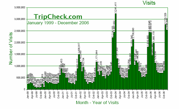
4.1.2 More than a Weekday Commute Tool
Oregon DOT’s expansion of the Highway Travel Conditions Reporting System was supported by ODOT management a key reason being that it is the data engine that feeds the very successful TripCheck.com. HTCRS also supports ODOT’s incident management, winter maintenance, and serves as the statewide database for road closures and construction activities. This multi-functional database serves several operational areas and the State’s traveler information system benefits from any enhancements.
The scope of traveler information has expanded beyond urban area ‘commute’ boundaries. What was once thought to be a regional, urban area need has been expanded to be able to provide statewide—and in some cases multi-state—information. Early traveler information programs focused largely on those urban areas where data was available. Metropolitan area freeway management systems provided some level of real-time travel conditions and congestion data that DOTs or regional entities could then use to provide commuters and travelers with current traffic conditions. Combined with private traffic reporting firms—through visual observations and police scanner data—as well as with television and radio media partners, the concept of ‘traveler information’ was thought to be most applicable to those urban area commuters during peak AM and PM drive times. While commuters are still a primary target audience and consumer of traveler information services, public agencies also recognize that tourists, inter-regional travelers, interstate and freight are also important demographics to consider when developing a traveler information program or implementing enhancements to current delivery models and options.
The expansion of traveler information to include real-time Statewide highway conditions, incidents, weather and even traveler services is a direct result of State DOT investments in databases and reporting systems that were designed primarily to serve as an internal maintenance and operations tool. With data being stored and available in a standard format on a Statewide basis–including closures, planned construction activity and in some cases incidents—agencies were then able to provide some level of consistent information for rural and interregional highways as well as urban area freeways. Integrating weather and road weather conditions data, whether from road weather information systems or through a partnership with the National Weather Service or another weather data provider, provides travelers with a comprehensive ‘snapshot’ of current travel conditions. The USDOT’s CLARUS initiative seeks to develop and demonstrate a robust and integrated weather forecasting and data management tool which will ultimately better support State transportation systems management and operations.
Multi-state metropolitan areas, such as Kansas City, Missouri; Washington, DC; and the Delaware Valley (Philadelphia) pose unique challenges in that there are often discrepancies between systems from different States, even though they may cover highways in one metropolitan area. Data formats, road/highway naming conventions, incident identification and severity indices and even level of content will vary from one system to another. Information sharing for traveler information purposes is largely being done on an ad-hoc basis, although there are several efforts underway looking at ways to integrate and enhance incident reporting and traveler information for key corridors that traverse multiple State systems. The I-95 Corridor Coalition is one example of collective efforts to enhance agency data sharing and information reporting. The Northwest Passage, which includes State DOTs from Minnesota to Idaho, is also looking at innovative approaches for agencies to provide consistent and comprehensive information across State borders.
4.1.3 The public sector as data aggregator
A key trend over the last decade has been the public sector beginning to take on the role of data aggregator – that is, collecting transportation, weather, incident, event, and other information to provide a robust and comprehensive set of transportation network conditions and impacts. This data aggregation role was traditionally thought of as being within the private sector toolbox. Traveler information services business model approaches developed in the 1990’s typically saw the public sector as a data provider for freeway sensor data and planned construction/closures, and incidents, although there were few systems that provided that kind of consolidated and centralized data resource. The private sector would take the responsibility for harnessing that data (sometimes from multiple public agencies) as well as other data types—weather, events, localized information—and perhaps even apply value added approaches to provide more granularity, congestion detail or information about traveler services and tourism. It would be a private sector responsibility to merge, or ‘fuse’ this data, work with multiple formats and data types, as well as produce an end product that resulted in usable information to the traveler. The private sector was encouraged to be innovative – and in fact, several approaches were tried to be able to provide a competitive edge in terms of the information packaging and delivery.
Recent years have seen an increase in the public sector taking on this data aggregation role, largely through public-public partnerships. As shown in Figure 2, MTC has taken responsibility for aggregating data from State, city, toll facilities, event promoters and others to provide a one-stop regional data source for road and traffic conditions information.
This graphic provides a ‘snapshot’ of the various outlets for this regional data feed, including private ISPs, public sector dissemination tools (traffic.511.org Web site), as well as the layers of secondary and tertiary ISPs that also benefit from the data feed. One of the challenges in quantifying data usage is actually tracking the different paths that the data may take – this graphic is intended to provide a high-level conceptual illustration of this data flow, and is not intended to represent all of the additional ISPs and media outlets that may be receiving data; capturing multi-level consumers is a distinct challenge in today’s data sharing environment. It is also important to note that this graphic shows only one facet of MTC’s data collection and aggregation efforts. MTC also aggregates regional transit data from more than 20 transit operators in the San Francisco Bay Area in support of the regional trip planner available through the transit.511.org Web site.
Figure 2 – Metropolitan Transportation Commission Traffic Data Feed
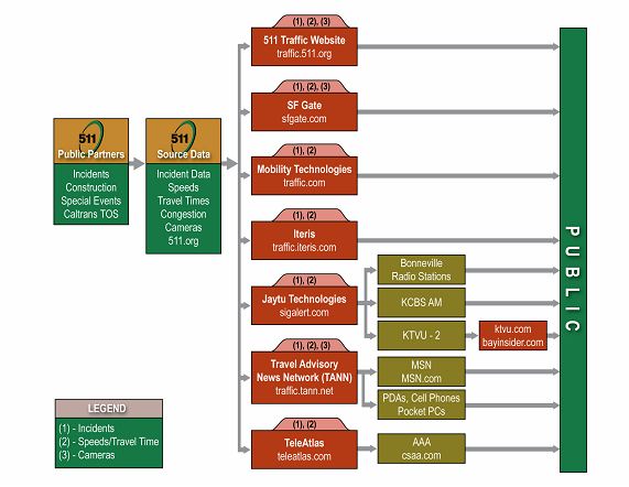
Another significant partnering effort between transportation and public safety are those partnerships that enable sharing of computer-aided dispatch incident data. A recent FHWA Field Operational Test sponsored pilot programs in Utah and Washington to establish automated connections between DOT reporting systems and public safety CAD systems to share incident data, and several other areas are spearheading similar initiatives. This has resulted in DOT’s having access to real-time incident location information, which can then be incorporated into traveler information systems. In the Utah example, Utah DOT (UDOT) implemented a CAD interface between the State’s reporting system and five other agencies: the Utah State Police, Salt Lake City Police, Salt Lake City Fire, Valley Emergency Communications Center (911) and Utah Transit Authority. This provides incident data for freeways and arterials, and UDOT has plans to connect to 30 other 911 call centers throughout the State. The CAD data feeds in Utah are two-way; agencies sharing their CAD data also receive information from UDOT. In metropolitan Phoenix, AZTech™ and its partner agencies have established interfaces to both the Arizona Department of Public Safety (State patrol) and Phoenix Fire (which dispatches for approximately 20 fire/EMS response entities), and now obtains incident information on State highways as well as arterials in the Phoenix metropolitan area. AZTech™ can then provide this aggregated data to the public via 511, Web, data feeds to the private sector and news media.
Among the leading public sector data aggregators is Trips123, TRANSCOM’s real-time traffic and transit information service. TRANSCOM is a regional transportation operations coalition, made up of 16 government agencies in the NY/NJ/CT metropolitan area representing highways, transit and public safety. Trips 123 began as a public-private partnership with the premise that the private partners (NEC Joint Venture—a joint venture of Telvent Farradyne and TransCore) would earn revenue by aggregating the raw data feeds from multiple agencies and selling that regional data, which includes travel times, incidents and event information along with for-fee personalized traveler services. However, at the end of 2006, the private partners agreed with the public sector partners not to continue due to limited profit levels. TRANSCOM then took over that operation, selling its aggregated content to private sector value-added resellers.
TRANSCOM is unique because it is a public sector entity that charges for traveler information data as a way to help offset operations and maintenance costs. It is one of the few, if only, public agency data collectors that does not provide data to third parties for free. TRANSCOM sees its core mission as operations and public safety, facilitating the sharing of information between its 16 member agencies and other public sector entities. Traveler information is a byproduct that it can charge for. In addition to the network of toll tag readers it operates, it has recognized there is real value in the data aggregation it has in place. It would require a great deal of time and effort for another entity to create the linkage between 16 different agencies in three states in order to duplicate the data feed TRANSCOM already has.
Many public agencies are also making use of private sector data. The private sector providers offer another source of transportation network conditions data, either as a supplement to what the public sector already collects, or on corridors that are not instrumented with publicly owned detection. Combining the private sector data with the public sector data brings several benefits, but also some key challenges. As part of contractual agreements with the private sector, there are often restrictions on what the public sector can share with outside entities. The private sector views their data as a commodity with a monetized value – they are also looking to establish partnerships to be able to sell their data. This puts a tremendous amount of responsibility on the data aggregator, for the purposes of this example, the public sector. Careful attention must be given to safeguard that commercial value and not include the restricted data within the publicly available data feed.
4.1.4 Enhanced and Personalized Information Available from the Public Sector
A significant turning point in traveler information is taking place with the public sector offering personalized information for travelers – at no cost to the user. This marks a key shift in what was previously thought of as a baseline level of ‘basic’ information that the public sector was able or willing to provide. The private sector had relied on a level of enhanced information, detail, ability to customize or personalize information as well as delivery methods (such as via cell phone) as a means of providing a value-added service for which subscribers would be willing to pay.
The Internet provided the technology and platform to allow the public sector to be more innovative with the types of information they could provide – map visuals, camera views, integrating multiple data sources, and the ability to select Point A and Point B segments allow users to select specific information they wanted to receive, even via the public-sector operated Web sites. With the widespread use of mobile phones and innovation in personal wireless devices, many of these capabilities can be transferred to portable—and extremely accessible—platforms. What is pivotal about this shift is the public sector developing innovative applications and delivery methods in response to an increasingly technology-savvy constituent base. While there is still a subscription component to some of these personalized services, the public sector is offering them at no charge to users.
This shift raises an important issue about the commercial value of personalized or enhanced traveler information services. While some public sector agencies are pursuing development of personalized traveler information services and delivery mechanisms more aggressively than others, some within the private sector may see this as directly competing with their models and applications. Later sections of this document discuss advances within the private sector for data collection, once a role that was thought to be the responsibility of the public sector; yet, a line is becoming similarly blurred in terms of the public and private sector roles for information dissemination. For some DOTs, these kinds of personalized or enhanced services—although beneficial for travelers—are not within their core missions, and they will continue to rely on private sector to provide the innovative technology applications to deliver them. Other public sector agencies, as shown below, are moving forward with enhanced applications, many of which are ‘push’ applications that were commonly associated with private sector, fee-based commercial services. These services provided by the public sector are relatively recent, and as such, there is not any quantitative information about the impact (or potential impact) of these services on private sector models.
Table 4 identifies some examples of innovative applications and services currently being provided by the public sector agencies throughout the country.
Table 4 – Enhanced Applications and Services Provided by the Public Sector
|
Speed maps and mobile traffic information via wireless phones |
|
||||||||||||
|
Customized route planning tools |
|
||||||||||||
|
Personalized alerts via email or text message |
|
||||||||||||
4.2 Data Collection
Data collection is an area where the most formal partnerships have emerged between the public and private sectors to support traveler information services programs and delivery. While there are several potential partners to support information dissemination (Web, media, etc.), agencies are looking to supplement their own data collection capabilities, and the private sector is providing more options than in years past.
4.2.1 Trends in Sensor Data Collection
The public sector continues to deploy roadway sensors to collect traffic data. There is a trend toward non-intrusive detection and away from inductive loops, but the type of data collected is the same: speed, volume and occupancy. The inherent limitation with traffic sensors, however, is their cost. They are expensive to install and expensive to maintain. Non-intrusive sensors, such as radar and acoustic sensors, are less expensive to maintain than loops and can use solar power and wireless communications if the site permits to reduce infrastructure costs. Agencies with large loop deployments in particular typically have a difficult time maintaining them to a high level of accuracy, with the exception of the few cities with strong public mandates that rely on the loops. One example is the Minneapolis-St. Paul metropolitan area, which has a highly visible ramp metering system that requires a high percentage of loops in service at any given time. Other cities with less operational need for the sensor data see far higher downtimes.
Under the ITIP program, eligible metropolitan areas can have Traffic.com sensors with little or no deployment cost to the agency. FDOT District 7 (Tampa Bay) opted into the ITIP program because at the time (2004), they did not even have a traffic management center and could not provide much in the way of traveler information. The ITIP program allowed them to quickly produce a traveler information program that could disseminate incident, construction and travel time information, as well as real-time data for internal operations. Unlike a typical franchise agreement, however, Traffic.com provides FDOT some compensation for the use of its right-of-way and allows use of its data for internal operations, but otherwise they charge FDOT for the right to disseminate high-quality travel time and incident data on its 511 system similar to any radio or television station. As compensation for access to its right-of-way, Traffic.com also pays FDOT a certain percentage of their estimated gross revenues specifically from the sensors, above and beyond a minimum threshold. In its first two years of operation, this compensation to the department was lower than had been expected.
A significant challenge in the infrastructure-based private sector data collection arena is working through the necessary permitting processes to be able to install infrastructure in the public sector right-of-way. While a contract may be negotiated for the data exchange, the permitting processes are often cumbersome and time consuming.
4.2.2 Trends in Probe Vehicle Data Collection
There is a limit to how many miles of coverage over which sensors can be deployed and maintained. In addition, point sensors do a poor job of accurately measuring traffic conditions on arterial streets with traffic signals. These limitations are leading both the public and private sectors toward non-infrastructure-based probe data collection. A proliferation of wireless communications and wireless-enabled mobile devices has garnered interest in using this data to track vehicles. Depending on the market penetration, a sample of the available data could depict traffic speeds over a broad area, including freeways and arterials.
The trend toward probe vehicle data collection by the private sector is also being driven by the telematics industry and the demands of auto companies. Radio stations are mainly concerned with the local market, which corresponds to their signal coverage; however, the telematics and mobile devices markets are national. These firms want to sell products to consumers without regard to whether they live in Omaha, Seattle or Miami. They see the nation as a vast expanse of road of which it would be impossible to instrument by conventional means (i.e., building infrastructure). The only way to do this is by using probes.
Given the extraordinary market penetration of cellular phones, if even a small percentage of cellular phones in moving vehicles could be tracked, this could be a rich source of traffic data. As a result, there has been a tremendous amount of effort given to this potential data source. Cell phone tracking, however, has proven to be a challenge, both technologically and institutionally. Cellular bandwidth is very expensive and carriers go to great lengths to conserve it by minimizing the amount of time two cell towers communicate with the same phone. As a result, the location of a phone can rarely be determined by triangulation. Furthermore, in rural areas where towers are sparse, a phone is under the coverage area of the same tower for a long time, making the specific location of that vehicle difficult to pinpoint. Institutionally, wireless carriers are extremely hesitant to share information on their subscribers that could compromise trust with their customers. The wireless market is so large, that it is not in the wireless carriers’ best interest to take any risks that would compromise their market share. Firms, such as Airsage, Cellint and others, have been working to overcome these issues for several years and are continuing to research more sophisticated techniques to overcome the technological limitations; however, this technology remains unproven as a viable option to support traveler information or operations.
Beyond cellular phones, Inrix, Traffic.com, and TrafficCast are seeking to capitalize on the prevalence of global positioning satellite (GPS) tracking technologies in commercial vehicle fleets. In order to do this, these companies are contracting with trucking, taxicab, and other companies with fleets of vehicles already equipped with tracking equipment. These contractual agreements are proprietary and none could be shared directly. Nonetheless, there are known to be challenges with this type of data. The quality of the data coming out of these agreements is highly dependent on the number and types of fleets represented. For instance, delivery companies tend to have assigned routes that they travel repetitively. Moving companies tend to sit on one place for extended periods during loading and unloading. Taxicabs tend to not travel on freeways. All commercial vehicles will avoid peak periods if they can. Therefore, commercial vehicle probe data is not without its challenges, though if the right mix of fleets can be combined, gaps can be filled and a wide net of coverage can be obtained without deploying expensive traffic sensors.
In a very recent development at the time of this writing, Wisconsin DOT signed an agreement with Inrix to receive traffic data on 250 miles of freeway on two routes (US-41 and I-43) between Milwaukee and Green Bay. This is the first agreement where the public sector is purchasing probe data from the private sector data collector-aggregators. Given the high volume of cars and trucks traveling between these two cities and the distance between them, as cited in the press release, probe data on this corridor could certainly be a more cost-effective solution than traditional sensors.
DASH Navigation is a start-up company that is basing its approach on the use of probes to collect traffic data. It sells a dashboard-mounted navigation system that provides routing instructions based on prevailing traffic conditions. DASH signed an agreement to use Inrix data as a base, in addition to the public sector data such as MTC data in the San Francisco Bay area; however, each DASH device is equipped with GPS and wireless fidelity and also acts as a probe vehicle. As more devices are sold, the quality and completeness of the information it provides will improve. Essentially, the users themselves are data collectors for each other. To differentiate itself from the other in-vehicle options, DASH aims to provide alternate route options in addition to traffic and road conditions on the user’s current route; however, their success still depends largely on a subscription business model.
Some of the factors that have influenced the surge in the market for navigation systems with real-time traffic are:
-
Quality of devices have improved while hardware costs have come down;
-
Cost of GPS has decreased while quality has increased significantly;
-
Wireless coverage has improved;
-
Map data has improved;
-
Devices have gotten simpler and appeal to a wider audience; and
-
They can deliver map-based, route-specific traffic information to drivers while en route.
4.2.3 Transit Information Services
Traveler information services, and partnerships to support them, have traditionally been discussed in the context of congestion, traffic and road conditions, and roadway weather impacts. There is an emerging business in the private sector to provide transit information to the public. Hop Stop is a Web site providing transit route and schedule information for five of the largest metropolitan transit systems: New York, Boston, Chicago, San Francisco, and Washington, D.C. Its business models include:
-
Attracting advertisers to post banner ads on its Web site or be included in its “City Guide”
-
Offering an Extensible Markup Language Web service a business can embed in its Web site for visitors to easily get transit directions to its address
-
Offering public agencies public transit trip planning services for their Web sites
Google Transit is an application in the Google Labs environment that provides point-to-point transit directions in ten different metropolitan areas at the time of this writing. Google is asking transit agencies for their itinerary information for free to support this venture. Some agencies are asking whether this data should be provided for free, especially agencies that have already invested considerable energy in developing trip planners on their own Web sites (e.g., wmata.com’s trip planner, Trips123.com and transit.511.org). In addition, Google has released a transit schedule format that they want carriers to submit their data to Google in. Agencies typically do not have the resources to package their data in a special format, nor can they regularly submit updates when routes and schedules change. While the future direction of this effort, the extent to which transit agencies will participate, or how successful it will be is not yet known, it highlights a case where the private sector has entered what has historically been the realm of the public sector. That being the case, it raises an important issue of the roles and relationships between the public and private sectors. The public sector is being forced to make policy decisions on data ownership and cooperation with the private sector that it was probably not able to anticipate needing to make.
4.3 Strategies and Challenges for Expanding the Public Sector Traveler Information Programs
As traveler information programs have evolved to include increased emphasis on broader forms of content, a wider range of dissemination channels, and increased partnering with both the public and private sectors for program delivery, there is an increased focus for public agencies to be strategic and visionary in how their programs operate and expand.
Several areas have recently completed, or are completing, strategic traveler information plans or business plans. Spurred by a need to provide real-time and relevant information to customers in balance with available public funds and resources, agencies are beginning to take very critical looks at how their traveler information programs can best operate and leverage existing operational investments – as well as identifying priority focus areas to grow and enhance their programs. Another key focus is identifying where partnerships could address a unique niche, fill operational gaps, or potentially off-set operational costs for the public sector. Although as demonstrated in section 3, the ability by the private sector to off-set the public sector traveler information services operational costs has not proved to be a successful, sustaining arrangement.
Kansas Traveler Information Strategic Plan – Case Study
Kansas cites the development of their 511 program as a success story in terms of their working agreement with the private partner. Prior to deploying 511, Kansas spent two years researching and shaping what they wanted their system to provide to their customers, as well as weighing the future operational costs and resource requirements. By the time they were ready to develop and implement, they were able to articulate very clearly not only what they wanted out of their 511 system, but also gained a more realistic sense of the requirements to sustain the system over the long-term as well as expectations KDOT had of its private partner.
KDOT, in cooperation with a private partner, is currently developing an Advanced Traveler Information System Strategic Plan that will build upon the traveler information research done prior to 511 deployment. Based on four focused strategies (potential to increase safety, transportation system efficiency and customer satisfaction, and to reduce traveler stress), the Strategic Plan is defining traveler information services goals/vision, priorities, commitments, and looking at alternative business models and approaches to assist KDOT in developing a cost-effective Plan for further developing traveler information systems in Kansas.
As part of this effort, KDOT is interviewing stakeholders throughout the State to get their input on key traveler information needs and priority focus areas. KDOT has always had a strong sense of ownership for traveler information. With guiding principles of responsible and responsive when it comes to customer service, KDOT is looking at creative approaches to be able to improve and/or extend what the department can currently provide. There is a good precedent for public/private partnering for traveler information in Kansas, which includes 511, excellent relationships with the media on a Statewide basis, marketing, and other partnerships to support data collection (early outcomes from a Cellint cell phone data pilot program is yielding positive results for travel time information in Kansas City). While Kansas sees some very positive outcomes of partnering with the private sector, KDOT also recognizes that it is important to have realistic expectations. Key areas where Kansas partners with the private sector are:
-
Product development;
-
Resources to solve problems; and
-
Resources to integrate or improve existing programs
MTC 511 Traveler Information Strategic Plan Case Study
MTC’s Strategic Plan, developed in 2006, outlines a 10-year vision for investment priorities, system enhancements, and business model approaches. MTC’s regional traveler information program is robust and multi-modal, and the strategic planning process needed to take into account the range of technical, resource, and partnering activities that have been instrumental in establishing the program thus far. As part of MTC’s strategic planning process, they took a critical look at the current functions and operations, as well as potential enhancements. MTC went through a process to assess the overall ‘effort’ required to deliver some of these functions, as well as the potential ‘impact’ a function has, or would have, on users. Once functions were generally categorized in terms of effort/impact, several criteria were considered and discussed during the analysis, and included:
-
Effect behavior (mode) change;
-
Reduce traveler stress;
-
Required operational support from other agencies or entities; and
-
Could be performed by another agency or private entity.
What emerged from this process was a priority list of potentially high-impact, regionally significant enhancements for MTC to consider as it developed its 10-year plan, as well as provide good justification to agency management about why certain enhancements were more mission-critical than others. In parallel to the traveler information Strategic Plan, MTC was also developing an agency-wide Strategic Plan, so the outcomes from the traveler information plan provided input to the broader regional directives.
Utah 511 Business Analysis Case Study
UDOT took a similar look at potential enhancements in 2006 and 2007 when it developed its 511 Business Analysis. UDOT migrated to a new 511 system operator in late 2004, and as part of this migration, implemented several enhancements to content and functionality. Subsequent internal and external discussions (among UDOT, tourism, commercial vehicle operators, and others), and a 511 user phone survey, yielded a list of additional potential enhancements for UDOT to consider incorporating into its phone-based traveler information service. Figure 3 shows the responses from 511 callers that opted to provide input to the survey.
Figure 3 – UDOT 511 Survey Responses
UDOT looked at the range of potential enhancements, and aligned them with the department’s four strategic goals:
-
Take Care of What We Have;
-
Make the System Work Better;
-
Improve Safety; and
-
Increase Capacity.
From that assessment, 19 potential enhancements to the 511 phone system and service emerged for further consideration. Some of these enhancements focused on improving weather information details, tourism/ski conditions information, commercial vehicle restrictions and amenities, airport information, as well as a live operator option. In reviewing the 19 potential enhancements, UDOT took its analysis one step further, and reviewed each potential enhancement as to how well it could support the Department’s four strategic goals, whether or not it met user needs, as well as its ability to encourage use of 511 by new customers. Along with these kinds of impact considerations, UDOT also looked at each enhancement as to its relative cost and ease of implementation and whether or not it required substantial resources from UDOT or other partners to implement. For some enhancements, such as tourism, event information, enhanced weather information and others, UDOT was able to benefit from lessons learned from other deployers, and they were interviewed to obtain information about cost and implementation issues. The result was a prioritized list of potential enhancements, along with recommended implementation and operations responsibilities or ‘conditions’ by UDOT as well as any partners that would be involved. Potential partners identified include the Utah Office of Tourism, Ski Utah, Salt Lake City Airport, and Utah Trucking Association, among others.
4.4 Traveler Information Services Policy Issues for the Public Sector
4.4.1 Responses to Emerging Private Sector Business Models
The previous section identified three areas that have developed strategic and/or business plans that considered the impact of the private sector partnerships for their traveler information programs. However, most of the public sector agencies interviewed as part of this review did not have a traveler information business plan in place, nor did they have a specific policy or directive in terms of involving private sector. Many agencies interviewed as part of this Review indicated that they are encouraged to partner with the private sector where it will be beneficial or address a key niche area that the public sector cannot. Given that the private sector can move far more quickly, innovate more, and take more risks than the public sector, public sector agencies often find themselves in reactive mode when new business models emerge on the private side. That is to say, public agencies typically do not have previously developed mission statements and guiding principles that enable them to respond appropriately to a changing traveler information services market.
A very recent case in point is Google, which has contacted DOTs across the country to obtain traffic information. As large and powerful a company as Google is, this has created waves in the industry. DOTs are, in many cases, providing traffic data to Google for free (as they do with numerous private entities) per their typical operating procedures. At the same time some are finding the costs for Google services, such as Google Maps, to be cost prohibitive. This is the case for the New Jersey DOT (NJDOT), which has begun to wonder if it should use its traffic data as a bargaining chip to negotiate fairer prices for Google Maps, which it would like to use for its public Web site. Compounding this issue is the fact that Google currently pays a very modest fee for NJDOT’s Statewide aerial photography, which it uses for its “satellite” and “hybrid” views on maps.google.com (and presumably Google Earth).
The key point here is not about the activities of a single company. Rather, it is that DOTs are having difficulty being nimble and proactive enough to stay ahead of the curve with respect to the private sector business activities; therefore, instead of focusing on policy issues, they can only make good decisions on a case by case basis as new issues arise. Agency policies that are several years old may need to be revisited. Some agencies are beginning to rethink their role, especially given the difficulty many agencies face finding the funds to maintain their sensor deployments. Should DOT’s be looking for additional sources of revenue to offset the costs associated with traffic data collection, aerial photography, etc? The answer to date has been “no” with few exceptions; however, this question is not likely to go away. Instead, it will continue to arise if new viable markets for traffic information emerge.
4.4.2 Data Ownership Issues
Who owns the data is a key issue facing public-private as well as private-private traveler information partnerships. In the past, it was straightforward. The public sector collected the data for its operations and provided it for free to those who wanted it. There remains the case of the traditional broadcast media, who receives this public sector information, supplements it with its own, and provides it to the public in exchange for advertising revenue. There are no ownership issues here, as long as the public sector continues to provide the data for free. Many public agencies interviewed as part of this effort view the data that they collect via publicly-owned infrastructure as being ‘paid for’ by the public, and do not view generating revenue as an option, whether that be charging for data, advertising on the public sector Web sites, or other models.
Questions of data ownership are not as straightforward when the private sector data collectors aggregate their data with the public sector data sources. This is the case with Traffic.com and the ITIP program; data ownership questions have been an important issue for agencies deciding whether to take part in this program. Under its typical arrangements, Traffic.com is able to utilize the public sector data sources for free, but the public sector agency does not have unrestricted use of the Traffic.com data. Depending on the contractual agreement in a particular market, the agency may not provide the Traffic.com travel time or incident data to the public on its Web site, DMS or 511 systems without paying for it.
There are two sides to this issue. On one hand, the ITIP was structured to enable the contractor to earn revenue to offset the cost of the program. If the public sector was able to provide all of the Traffic.com data to the public for free, it would undercut its ability to sell or otherwise earn revenue from its value-added services: supplemental sensor data, aggregation with the public sector data stream, data quality filtering and dissemination via various media. As a result, the public sector partner becomes just another paying customer of the merged data, albeit with special deals in some cases.
On the other hand, some agencies who entered into ITIP contracts in order to take advantage of external funding to kick-start or otherwise enhance its traveler information program have found the restrictions on the ITIP data limiting. In the case of the Illinois Tollway, for instance, the ITIP agreement prohibited the posting of ITIP travel times on the agency’s DMS. In response, the Tollway developed a program to calculate its own travel times, without the ITIP sensors. As a result, the travel times on the DMS and the Traffic.com Web site would differ slightly.
This is not an ITIP-specific issue. In the San Francisco Bay Area, MTC has taken an active role in traveler information. MTC aggregates data from multiple public agency sources and makes it available to the public for free via its 511 phone service and Web site. It also makes a data feed available for free to the myriad private partners and ISPs providing value-added services, in some cases with their own supplemental data feeds, in other cases with customized data delivery services. While merging all of the public and private sector-collected data would provide a single, uniform, high-quality data stream that would increase the value of 511 or any traveler information services service in the Bay Area, such an arrangement does not adequately compensate the private sector data providers for use of their data. In addition, it undercuts their ability to provide value-added services because they will be competing with a service (511) that they are helping to support.
This raises important issues about “safeguarding the commercial value” of private sector traffic data. Section 2.2 of this report referenced a 2001 European Communities Commission Recommendation regarding a legal and business framework for public/private partnerships for traffic and travel information. Within this recommendation was a statement that Member States of the European Commission “…adopt measures to ensure that public authorities and public agencies safeguard the commercial value of all proprietary traffic data and travel information supplied to them by private TTI service providers.” The European Commission noted that participation by the private sector was key to accelerating deployment of traffic and travel information services throughout Europe. Although the recommendation is just that, a recommendation (it notes that it would be premature to issue a regulation or directive), it does recommend some key guiding principles that encourage the public sector to provide an environment for commercial deployment of enhanced services to travelers. To date, there is not a comparable set of guiding principles that have been developed in the United States, although the Federal, State and local public sector recognize that involvement from the private sector is a critical piece of the traveler information arena.
4.4.3 Traveler Information Services Data Quality
For the public sector data providers, traveler information services data quality has been receiving more attention in the past several years; however, improvements in data quality have largely been driven by operational needs and not traveler information services. In addition, limited operations and maintenance budgets have typically constrained improvements in data quality. Nonetheless, SAFETEA-LU, Subtitle B, Section 1201, mandates that:
“The Secretary [of Transportation] shall establish a real-time system management information program to provide, in all States, the capability to monitor, in real-time, the traffic and travel conditions of the major highways of the United States and to share that information to improve the security of the surface transportation system, to address congestion problems, to support improved response to weather events and surface transportation incidents, and to facilitate national and regional highway traveler information.”
Following the adoption of SAFETEA-LU, FHWA issued a Request for Information (RFI) to solicit feedback from the public and private sectors about the Real-Time System Management and Information Program. In this RFI, FHWA proposed some parameters for what would constitute ‘real-time’ information under the program guidelines. The RFI proposed the following definitions for real-time information:
-
Construction closures/openings within 30 minutes; 15 minutes in metropolitan areas;
-
Confirmed road or lane blocking incident information within 15 minutes;
-
Roadway weather conditions updated at least 30 minutes;
-
Congestion information updated at least 15 minutes;
-
Travel times reflect conditions no older than 10 minutes; and
-
Transit disruptions updated at least 30 minutes.
FHWA’s contract with Traffic.com for the ITIP program sets the following minimum data quality levels for real-time information:
-
95% availability;
-
90% accuracy; and
-
2 minute latency.
While these timelines set a bar that should improve the quality of real-time traveler information from the public sector, for the private sector data providers, the market will ultimately determine how accurate their data needs to be. Furthermore, these data providers need to be able to quantify and demonstrate the accuracy of their data in order to establish its value to prospective customers. These customers include data aggregators such as the private sector firms Inrix and Traffic.com, as well as the public sector agencies such as MTC. Aggregators need to be able to harmonize disparate data sources, which may have varying data quality. Inrix, which collects probe vehicle data from various vehicle fleets and traffic sensor data from public agencies, must be able to fuse this data together, often harmonizing different types of data over the same stretch of road. To do this, it must be able to determine which source to use when they differ. MTC must also make judgments on data accuracy when it contracts with the private sector data collectors. In addition, it may not be enough to know a data provider’s sensors are 90% accurate if that 10% of error is concentrated at key locations at key times of the day.
In addition, firms such as TrafficCast or Inrix who sell their fused data as VARs must be able to demonstrate the quality of their data to prospective customers and differentiate themselves from their competition. It is still an open question just how accurate that data needs to be, or even what level of accuracy it is possible to achieve. Nonetheless, Inrix commissioned a study by Frost & Sullivan that compared the accuracy of its data to its chief competitor, Traffic.com. The report compared the miles of coverage between the two companies in three major markets and the accuracy of the data from both firms compared with “ground truth” travel times from test probe vehicles. Results were reported in several different metrics such as mean error and root mean square percent error. This is a greater level of detail than prescribed in the SAFETEA-LU legislation for real-time travel time data, which only states it must be no older than 10 minutes and does not specify a target for accuracy. This has been a common differentiation between the public and private sector when it comes to specific data quality parameters; the public sector wants to provide accurate information, but has not articulated the same level of accuracy precision for its data as the private sector.
Experts have proposed accuracy requirements for real-time traveler information (Feige, et al., 2004) and studies have been performed to arrive at this number (Toppen and Wunderlich, 2004), but these studies have not yet been validated with empirical evidence. The private sector firms are undoubtedly working to uncover the answer to this question as it will affect the resources they commit to data collection in a given market. In the end, it will not be determined by experts, studies or the data providers themselves; rather, customers will determine the accuracy they will require for the price they are willing to pay.
For Traffic.com, which deploys sensors, higher quality data requires a higher density of sensors and better maintenance of those sensors. For aggregators of probe vehicle data, higher quality data requires higher volumes of probe vehicles, which may translate into contracts with more companies with GPS-enabled vehicle fleets. Regardless, given limited resources, there is a fundamental tradeoff between allocating those resources to improving the accuracy of data on covered roadways and increasing coverage to additional miles of roadway, which could be outlying freeways or arterial streets. In any given market, however, this tradeoff is not yet known empirically.
4.4.4 Summary of Policy Issues and Considerations
None of the agencies surveyed as part of this State of the Practice Review indicated that they had any formal policies in place to support their traveler information programs. While several agencies acknowledged that they had agreements with both the public sector as well as the private sector to govern certain aspects of information sharing, formal policies were not identified. There are also examples of programs that have established some guiding principles that encourage participation by the private sector, but there are limited formal policies to actual govern those relationships.
A key question to be asked is: Is there a need for a formal policy, and at what level should that be addressed?
Issues such as data collection and data ownership will continue to emerge, and may require policy-level frameworks developed at the regional and local level to govern business relationships for traveler information. This would apply to partnering with the private sector, and potentially even partnerships among public agencies.
As demonstrated by the range of traveler information programs and models featured within this report, regional, statewide and multi-state traveler information programs have evolved within very unique environments. Some public sector agencies are more inclined to partner with the private sector in a contracted or outsourced basis than others. Similarly, there is a strengthening in some areas among the public agencies to be able to better share data that is available on a regional or statewide basis. Policies, if needed, would need to address specific issues within an area that may or may not be within the control of the DOT or other lead agency for a traveler information program.
One area where there has been consistent policy-level activity is sharing of video. While there are certain public agencies that require agreements for access to operations data (i.e., detector data, incident data, etc.), it has typically been the practice of the public sector to develop very specific agreements for entities that wish to access their CCTV video, such as for broadcast via TV traffic reports. These agreements often spell out very specific conditions, such as sourcing the CCTV to the owning agency, limitations on use, stipulations on when video can (or cannot) be accessed, and so on.
The preceding subsections outlined some very specific issues relative to data ownership, responsibility of the public sector for not infringing on the ability of private sector to monetize their products and services, as well as the challenges faced by the public sector in responding to new private sector models or business activities. It is important to note that with the inroads that the private sector is making into the data collection marketplace, as well as with the range of private sector companies that are establishing a national scope to their services, issues will continue to emerge that may pose challenges for the public sector when entering into business relationships with the private sector – either contracted, zero-dollar agreements, or other arrangements. Similarly, as the public sector takes on a stronger role for regional data aggregation, agreements among their public sector peer agencies for data or resource sharing will be needed to govern those operational relationships.
From a policy standpoint, it would be difficult, if not impossible, to be able to capture the full range of potential issues that could emerge from a public/private or public/public arrangement. Policies, governance structures, legislative authorities, and inter-departmental relationships will vary from agency to agency and from state to state. While a policy could provide an overarching framework from which to develop specific parameters for a business relationship, it would likely be the responsibility of the state or region to coordinate with their appropriate Administration, Legal, Telecommunications, Information Technology, Government Affairs or other appropriate departments to discuss potential business arrangements and identify potential ‘policy’ or contractual issues that may result from such an arrangement. As regions work toward more collective coordination for traveler information, there may also be multi-agency considerations for agreements or policy level approaches. This will also be beneficial to identify where there may be conflicting policies within an agency (or partnership of agencies) that could impact any business arrangements with the private sector.
SAFETEA-LU in and of itself sets a key policy regarding the establishment of the Real-Time System Management Information Program. Subsequent federal legislation could then define, in more detail, the terms and parameters needed to support this program, which would provide regions and states with a foundation from which to establish some specific policy frameworks, policy directives and principles within their own agency operating and administrative requirements.
4.5 Other Private Sector Trends
While the private sector trends in traveler information have been touched on repeatedly throughout the course of this document, this section will summarize the high points. While the public sector has—albeit with some exceptions—gravitated toward more ownership by the public sector over its traveler information services programs, there are some interesting trends taking place in the traveler information market on the private side. The public at large recognizes a definite value to traveler information and this is only becoming more true as congestion worsens nationwide. As a result, the private sector is continually looking for good business models to capitalize on the traveler information services market. At the same time, advances in technology and trends in related business areas have brought about changes in all parts of the supply chain of traveler information services information delivery.
-
Subscription models. The subscription model has seen varying levels of interest over the last several years. Nonetheless, that has not stopped private enterprise from continuing the search for the “killer application” that will trigger demand for fee-based services. It has long been believed that poor data quality and inadequate delivery methods have been the key reasons consumers will not pay for traveler information services. Consumers need to see value above and beyond the incumbent radio traffic reports in order to be willing to pay for traveler information services. Firms such as TrafficGauge and DASH Navigation continue to pursue a subscriber business model; however, the trend in subscription models appears to be toward mobile devices, such as smartphones or navigation systems. These combine the recognized benefits of Internet traveler information (map-based, customizable, potentially route-specific) with in-vehicle delivery, long a primary reason for the success of radio traffic broadcasts.
An increasingly popular trend with the subscription model is now toward bundled services. Traffic data, which may not garner many subscriptions by itself, is being bundled as a feature within navigation systems that also provide travel services such as directions to the nearest McDonalds or Starbucks. Or it is included in the cost of a monthly data service on a handheld portable device. These could be navigation systems or smartphones, the latter of which may include many different data services (text messaging, Internet, etc.) bundled into a single monthly fee. In this model, traffic data may not be a draw in and of itself, but simply one component of an entire package with a single monthly fee. Providers recognize that any one feature of the bundle may not appeal to everyone, but different features may attract different customers. Section 3.5 referenced several business-to-business models to enable the integration of traffic with navigation systems (whether portable or in-dash units).
Taking this a step further, in the fall of 2006, Clear Channel Radio’s Total Traffic Network entered into a multi-year agreement with BMW to provide real-time traffic data as a standard feature in navigation systems for certain 2007 models. The novel feature of this arrangement is that it requires no additional subscriber fees over the lifetime of the vehicle. It is too early to say whether other traffic information providers, auto manufacturers or device manufacturers will follow suit. Nonetheless, it highlights a trend away from monthly subscriptions and toward bundled services.
-
Advertising models. The most lucrative market for traveler information remains advertising on traditional media (i.e., broadcast radio and television). This is true for Traffic.com, Clear Channel, Beat the Traffic, and many other firms. While many other business models and revenue targets continue to emerge, none have demonstrated the sustainability of radio and television traffic reports. Firms in this market either provide continuous feeds of traffic information to radio stations or employ their own radio personalities to report the traffic on the air. Advances in technology that are improving data collection and aggregation are providing alternative business models, but they are also improving broadcast traffic reports through improved information, visualization capabilities and new features in some markets such as travel times. There is no indication that other business models will significantly encroach upon broadcast advertising models in the near future.
-
Trend toward a national approach. In another trend, the private sector is taking more of a national approach, whereas previous traveler information services businesses had a very narrow regional focus. In the past, many public/private partnerships were not successful where there was an expectation for the private sector to generate revenue to sustain a single regional system. Today, Traffic.com is a good example of the private sector taking a national approach, albeit Traffic.com information is very regionalized. They have developed systems for traveler information that can be replicated in any number of metropolitan areas—it is modular enough so that it is not dependent on success in just one area, and development efforts can be leveraged across several potential implementations. In fact, Traffic.com built its information technology infrastructure and business model for the ITIP program to support a multi-city program. This national approach enables firms to market to nationwide data disseminators such as mobile device and automobile manufacturers.
Section 5. Conclusions
This State of the Practice Review has sought to provide a survey of traveler information services business models in the United States. A brief recap of the changes in thinking over the past ten years was presented, as well as the predominant business models in use today along with real-world examples of successes, innovative approaches, and those approaches that have not proven viable or sustaining. Finally, several key trends are highlighted that may be signals of where the industry is headed, both for the public and private sectors. While there is a diversity of approaches in various locations and markets across the country, the findings in this document are general in nature and exceptions undoubtedly exist.
Several traveler information services business models have been tried over the years with varying degrees of success. In short, the following lessons have been learned:
-
The most successful business models have had significant ownership and involvement by the public sector, albeit at significant cost to the agency. This could be fully public-centered operations or contracted operations, but if the funding and backing of the public sector is driving the traveler information services program, it has the greatest chance of being sustaining. This remains the predominant successful business model.
-
Franchise operations have not proven to be sustaining in the past, though they are still being launched in different forms. These models limit the extent to which the public sector can disseminate free information to leave room for a private sector entity to sell its information services and earn a profit.
The private sector continues to innovate with new technologies and building off of lessons learned. Key lessons learned from the private sector initiatives are:
-
While the demand for traffic information is as high as it has ever been, most individual consumers are not willing to pay for it in the form of a subscription. There is growing interest in the subscription model by the private sector, and notably increased partnering among data, device, mapping and navigation partners to deliver ‘bundled’ services to subscribers, of which traffic is a key part.
-
Advertising models are showing promise in terms of providing sustaining revenue, and broadcast media advertising remains the primary source of revenue and profit. Internet advertising by itself does not typically provide a sustainable revenue stream.
-
The private sector is also looking for good new models, and the proliferation of ‘supply chain’ and business-to-business relationships for enhancing traveler information services to the consumer points to continued model evolution on this front.
Emerging trends for the public sector include:
-
511 has put a very public brand on traveler information, and the implementation and operations of 511 have largely been spearheaded by the public sector. Recognizing that traveler information is an important component of an agency’s overall operations mission, the public sector has dedicated the resources and funding to provide this service to its customers and constituents. With 511 phone and Web services, there has often come a need to implement enhancements to other areas to better support traveler information. These include incident reporting databases, planned closure/restriction reporting systems, in-house information technology resources, and strengthening partnerships with other public sector agencies.
-
In many areas, the public sector is assuming greater responsibility for data aggregation. Many major metropolitan areas are aggregating incident data across multiple municipalities including computer-aided dispatch systems and local transit authorities. Similarly, State DOTs are also bringing together data from multiple agencies and devices as part of statewide and regional reporting systems and databases, which then feed traveler information systems and services and data is made available to the private sector. Multi-jurisdictional operations are becoming more common as indicated by the growth in facilities where DOTs, public safety, and in some cases transit, are collocated. The byproduct of this is a broader collection of relevant traveler information beyond an area’s major freeways – there are regional, statewide and multi-state impacts.
-
Enhanced and personalized information, which was once the domain of the private sector, is becoming more common among the public sector agencies. Such enhancements include customized route planning services, personalized email or text message alerts and delivery to mobile devices.
At the same time the public sector has taken on services once thought to be the role of the private sector, the private sector has engaged in activities once thought to be within the jurisdiction of the public sector. These and other private sector trends include:
-
The private sector is taking a greater role in data collection. The limitations of public agency sensors is becoming apparent and other methods will be needed to provide a higher quality of information both in terms of accuracy and coverage beyond major freeways. Probe vehicle technologies are becoming more common for several reasons, among them the ability to re-use existing vehicle tracking technologies in commercial fleets at low cost.
-
The maturation of the mobile device market (smartphones and navigation systems) has provided a new outlet for traffic information. The private sector is seeking to take advantage of those technologies to bundle traffic information into broader service agreements. As a result, there is strong renewed interest in the subscription model.
-
The VAR model is evolving and taking advantage of the various different supply chains for traffic information. While some businesses are taking on the entire supply chain on their own, from data collection to dissemination, most are reaching agreements with other firms to diversify among many different markets with different end users, delivery mechanism and geographic locations.
Key issues going forward for the public and private sectors are:
-
As data is being collected from multiple sources and using multiple technologies (sensor vs. probe), the data aggregation role is becoming more significant. Entities that can successfully combine these data sources into a high quality data stream stand the best chance of being successful. In addition, it is important for all collectors and users of data to be able to assess data quality both to accurately price their own services and evaluate the services of others.
-
As the roles of the public and private sectors are blurred, it will be increasingly important for the public sector to develop policies to adequately guide their involvement in the private sector business activities. Especially if the public sector agencies begin purchasing data and services from the private sector, they will need to assess their typical procedures of providing free data to third parties.
In all of these issues related to traveler information services business models, it is important to note that both the public sector and the private sector both have value to leverage to meet their goals. Some examples are listed in Table 5.
Table 5 – Examples of Value Offerings from the Public and Private Sectors
|
Public Sector |
Private Sector |
|||||||||||
|
Right-of-way |
Specialized expertise, such as a data fusion engine to aggregate multiple sources of data |
|||||||||||
|
Multi-jurisdictional data sharing arrangements for operations |
Business-to-business relationships to collect and disseminate data within a supply chain |
|||||||||||
|
A phone number with national branding (511) |
Company recognition, reputation or branding |
|||||||||||
|
Traffic sensor data |
Traffic sensor data |
|||||||||||
|
Government funding with a mandate to provide traveler information |
A Web site and email alert service, which provides opportunities for advertising revenue |
|||||||||||
|
Policy and regulatory influence to encourage private sector involvement and a competitive environment |
Increased innovation, enhanced delivery methods and partnerships |
|||||||||||
The public sector typically seeks to return as much of that value as possible to taxpayers. The private sector leverages its value to earn a sustaining profit. These two objectives are sometimes in concert and sometimes in conflict. The way in which all parties work together to meet their objectives as technologies and new ideas advance will determine the future of traveler information services in the United States.
Appendix A – References and Resources
511 Deployment Coalition, Deployment Assistance Report #1: Business Models and Cost Considerations, January 2002.
511 Deployment Coalition, Implementation and Operational Guidelines for 511 Services, Version 3.0, Chapter IV, September 2005.
Bradshaw, C., M. Hallenbeck, D.McIntosh, Washington State Department of Transportation Advanced Traveler Information Systems Business Plan. Research Report, Report No. WA-RD 461.1, Washington State Transportation Center (TRAC). June 1999.
Burgess, L.M., Dale, J and P. Pretorius, NCHRP 20-7/215: Statewide Incident Reporting Systems Business and Technology Plan. Transportation Research Board, Washington, D.C. 2006.
Commission of the European Communities, Official Journal of the European Communities. Document No. C(2001) 1102, Recommendation on the development of a legal and business framework for participation of the private sector in deploying telematics-based Traffic and Travel Information services in Europe, July 2001.
Chen, Kan, ATIS Practices in Europe and North America: A Report on Comparative Analysis. Prepared for Federal Highway Administration. October 2002.
Crotty, M. et al, “Roles and Responsibilities for MTC and Partners.” 511 Strategic Plan, Metropolitan Transportation Commission, Oakland, CA. April, 2006.
Federal Highway Administration, Data Fusion for Delivering Advanced Traveler Information Services. Publication No. FHWA-OP-03-119, Washington, D.C. 2003.
Federal Highway Administration, Traveler Information Systems in Europe. Publication No. FHWA-PL-03-005. August 2003.
Feige, Margiotta, R. and S. Turner, Traffic Data Quality Measurement Final Report. Federal Highway Administration. U.S. Department of Transportation. Publication No. FHWA-JPO-05-001. September 2004.
Intelligent Transportation Society of America, Choosing the Route to Traveler Information Systems Deployment: Decision Factors for Creating Public-Private Business Plans, an Action Guide. 1998.
Intelligent Transportation Society of America, Closing the Data Gap: Guidelines for Quality Advanced Traveler Information System (ATIS) Data. September 2000.
Intelligent Transportation Society of California, California ITS: Developing the Business!. Final Report, Hagler Bailly Services, Inc., July, 1999.
Intelligent Transportation Society of California, Intelligent Transportation Systems Deployment Initiatives: A Shared Vision for California, February 2000.
Minnesota Department of Transportation, Minnesota Statewide Plan for Advanced Traveler Information Systems, 1998.
Toppen, A. and K. Wunderlich, Understanding Key Tradeoffs For Cost-Effective Deployment Of Surveillance To Support Advanced Traveler Information Systems (ATIS). U.S. Department of Transportation. Publication No. FHWA-JPO-04-040. May 2004.
Utah Department of Transportation, 511 Business Analysis. Kimley-Horn and Associates, Inc. January, 2007.
Real-Time System Management Information Program, Federal Register Vol. 71, No. 86. May 4, 2006, 26399-26403.
Appendix B – Web Survey Questions
1. Name of the system or geographic area served by your traveler information system
2. How long has your agency been providing traveler information to the public (since what year)?
3. Describe the geographic area covered by your traveler information system:
-
-
Statewide
-
Regional
-
City/metro area
-
Covers more than 1 state
4. What is your target audience for advanced traveler information? Answer as many that apply.
-
-
General public
-
Commuters
-
Tourists/non-residents
-
Public transportation users
-
Commercial vehicle operators
-
Inter-regional travelers
-
Other (please describe)
5. What are the components of your traveler information system:
-
-
Dynamic message signs
-
Highway advisory radio
-
511 phone system
-
Other phone information system/hotline (toll-free)
-
Traveler information web site (public sector operated)
-
Traveler information web site (private sector operated)
-
Email alerts
-
Personalized information
-
Other (please describe)
6. Do you have partnerships with other public sector entities to support your traveler information program? If yes, check all that apply: (For each of these responses, we will ask what role – data collection, consolidation, dissemination)
-
-
Municipalities
-
Counties
-
State
-
Law Enforcement
-
Transit
-
Airport
-
Other public entity (please describe)
7. Is there any resource sharing among public sector partners to provide traveler information? Please describe.
-
Cost sharing
-
Data collection infrastructure
-
Staff
-
Other resources
8. Are there provisions or policies at your agency that allows or encourages private sector partnering? Please describe.
9. If your agency has any formal agreements with private partners for portions of your traveler information program please indicate applicable private entities below.
-
-
Television media
-
Radio
-
Traffic reporting services
-
Traffic data providers
-
Internet/Web sites
-
Private partners are not involved
-
Other (please describe)
10. According to what arrangements do private partners provide data content to your traveler information program?
-
-
Public sector pays fee for data
-
Public sector receives data in exchange for access to right-of-way
-
No charge to public sector for data
-
No charge to public sector for data
-
Private partners are not involved
-
Other (please describe)
11. According to what arrangements do private partners disseminate information to the public?
-
-
Public sector contracts with private sector
-
No charge to public sector for dissemination
-
Private partners access public sector data at no charge
-
Private partners are not involved
-
Other (please specify)
12. What is the impact of private sector on your agency’s traveler information program?
-
-
Private sector involvement has decreased public sector responsibility for traveler information
-
Private sector involvement has not decreased public sector responsibility for traveler information
-
Private sector is not at all involved with our program – public sector has full responsibility
13. Overall, how has your relationship with private sector partners for traveler information changed or evolved over the last five years? Please describe.
14. Does your agency have a traveler information business plan or business model document?
-
-
Yes
-
No
-
There is a business plan in progress
15. If you answered “yes”, how often is the business plan reviewed or updated? Please describe.
16. What would you estimate is your annual expenditure (or annual budget) for your traveler information program?
17. Please describe any planned changes to the partnership structure of your traveler information program (if applicable).
![]()
U.S. Department of Transportation
Federal Highway Administration
Office of Operations
1200 New Jersey Avenue, SE
Washington, DC 20590
www.ops.fhwa.dot.gov
FHWA-HOP-07-115
May 2007