Getting More by Working Together — Opportunities for Linking Planning and Operations2. Opportunities for Linking Planning and Operations2.2 Data SharingBACKGROUND
Using advanced technologies, it is now possible to collect and store vast amounts of data to support the planning and operation of transportation systems (see Exhibit 3). Roadway loop detectors, for example, can provide real-time information about traffic volumes and speeds. Global positioning systems and radio/cellular phone triangulation can determine vehicle location and speed. Electronic fare collection and automatic vehicle location systems can record detailed information on transit service and use. These rich data sources not only replace many more expensive traditional data collection methods such as manual traffic counts, surveys, and floating car studies, they also allow data to be combined across modes and operational environments in new ways. In doing so, these data can create a more complete picture of how policy, infrastructure, and service changes affect the performance of transportation systems. What Is Data Sharing?Data sharing refers to a broad range of activities that support the full use of readily available transportation information. Many government and private organizations collect data that can inform the design and operation of transportation facilities and systems. First and foremost, data sharing implies awareness about such data sources and a fresh perspective in considering their potential value in new uses. Data sharing typically requires that organizations store data and make it available in a useable format. It may also involve a forum to coordinate with other organizations about potential data exchange opportunities. How Can Data Sharing Create Stronger Linkages Between Planning and Operations?The collection, storage, and sharing of transportation data provides numerous opportunities to solidify the link between planning and operations. Real time data from system operators allows agencies to measure and track the characteristics of the transportation system that are closest to what users experience. This, in turn, allows planners to develop better performance measures and other analytical tools. As planners come to value the data available from management and operations programs, they build a broader awareness of such programs and their importance. When operations agencies share their data, they often increase their focus on data quality and transferability, and they may develop new relationships with other agencies, universities, and other institutions in the process. Why Is Data Sharing So Important?Interest in data sharing is prompted in part by growing concern about the performance of transportation systems in addition to the performance of individual facilities, and by the increased focus on system management and operations as a tool to enhance transportation systems performance. Efforts to improve travel time reliability and predictability require more detailed data than has traditionally been analyzed by planners. The system focus means that data on conditions are needed virtually everywhere on the transportation system, across jurisdictions and modes. This contrasts with the typical "hotspot" approach that has governed data collection and transportation management in the past (see Exhibit 4). Exhibit 4: Typical Differences in Survey and ITS Data 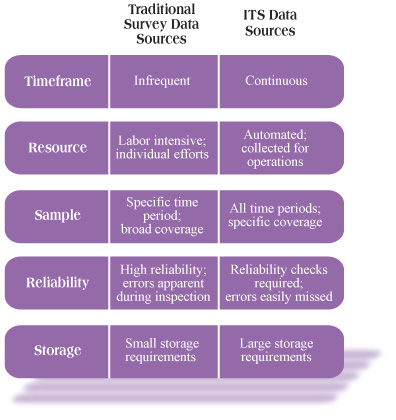
As data collection and storage have become more cost effective, the capacity for transportation practitioners to make use of vast amounts of data for policy analysis has also increased. For example, desktop geographic information systems (GIS) applications have continued to become more advanced and more pervasive. GIS is a valuable tool for organizing spatial data from multiple sources. Other powerful software tools allow simulation of complex traffic conditions on individual computers. For years, many groups within State transportation agencies have operated independently, collecting their own information using different reference systems, databases, and analysis packages. Many States are now using relational databases, GIS, and other tools to assist them in bringing together these dissimilar datasets. The ITS architecture also encourages the identification of new data sharing opportunities. One element of the National Architecture (and regional architectures) is the information flow analysis. This is typically diagramed in a way that illustrates the appropriate information flows between each major component of the transportation system, thereby highlighting potential data sharing options. A related element of the National ITS Architecture, the Archive Data User Service, was designed to facilitate alternative uses of ITS data, including use of data for transportation planning. The Archive Data User Service helps promote a regional data sharing approach that is consistent with current and anticipated technological capacity. Organizations that receive data benefit from valuable information on transportation system demand and performance, often at little or no cost. Sharing data can benefit the organization providing data by building awareness about the agency’s programs and creating a check on data accuracy. Data sharing may necessitate changes within the agencies receiving data, including a willingness to evaluate planning practices and operations strategies in light of more complete information. TAKING ADVANTAGE OF LINKAGE OPPORTUNITIESData sharing is often a first step toward broader coordination between planning and operations. Sharing data will require establishing new relationships with other agencies and building mechanisms to support sustained data exchange and storage. Issues such as data formats, accuracy, consistency, and appropriate use can complicate the process of establishing inter- and intra-agency data sharing programs, but these challenges can be overcome. A number of small steps can help to initiate the process. As agencies learn about resources available in their region, they are likely to be more interested in exploring the benefits of data exchange. This section discusses several specific opportunities to use data sharing as a mechanism to link planning and operations. Develop a Regional Data ClearinghouseA central data clearinghouse can help facilitate access to a region’s full range of transportation data for both planning and operating agencies. This requires that a regional agency take stock of all transportation data that are available and develop partnership agreements to make data retrievable from a central access point. There will be barriers for certain sensitive data sources, but the effort should include all planning and operating agencies, public safety agencies, as well as private sector sources such as freight companies. An initial effort to compile a list of all electronically available data sources is an excellent place to begin a discussion about regional data sharing mechanisms. The regional ITS architecture is likely to include a detailed description of the types of data that are available from various transportation, emergency management, and public safety agencies. In this way, the ITS architecture can be used to guide data sharing and the development of a central clearinghouse. (Regional ITS architecture opportunities are discussed in Section 2.7.) Coordinate Data Resources With Transit Agencies
As a result of ITS deployments, transit agencies are becoming more valuable data sharing partners enabling them to participate in regional planning activities in new ways (see Case 4). With numerous vehicles throughout their service area traveling on regularly scheduled routes, transit agencies are in an excellent position to provide roadway system data using automatic vehicle location technology. This includes information on current speeds throughout the roadway network and changes in speeds on a particular route throughout the day and over longer time periods. When such information is collected and stored, it can be useful for evaluating the impacts of system improvements. For example, by comparing express bus travel times during the specified time periods on a particular day, such data could allow evaluation of the deployment of a traffic control feature during special events. When they share data with other agencies, transit providers assist with improving regional system operations by enhancing roadway network monitoring, and they assist with improving regional planning by facilitating the development of performance measures. Transit agencies themselves benefit from vehicle location data when it provides information on real-time system conditions, such as incident information. And communicating real-time vehicle location and arrival information to transit customers improves transit service and can boost ridership. Use Special Events to Initiate New Data PartnershipsAmidst the day-to-day duties of transportation agencies, taking time to discuss data collaboration is often viewed as a low priority. The need to reach out to new agencies can be heightened when preparing for special events. Special events create an opportunity to develop awareness of data that are available from other organizations (see Case 5). When participating in transportation planning for a special event, consider how the agencies involved might share data on a long-term basis. Use Universities to Help Develop Integrated DatabasesUniversities are natural partners for developing data sharing resources (see Case 6). Their technological capabilities, their positions outside of the established institutional framework, and their role in developing a new generation of practitioners all contribute to their value as data sharing partners. Most major universities can be expected to have the technology and expertise required to develop large data collection, storage, and distribution systems. Moreover, universities that are involved with transportation policy, engineering, or planning may have already taken steps to develop regional transportation databases that link existing data sources in innovative ways. Universities are typically perceived to be somewhat independent of local and regional transportation agencies. This means they may have a unique capacity to build bridges between agencies. And because universities are usually removed from day-to-day collection and use of transportation data, they may be able to offer creative ideas for new uses of existing data. Finally, when local universities are focused on developing integrated transportation data management systems, students involved with this work will leave the university with an understanding of the data sources and how they can be related. This helps train a generation of professionals who see transportation planning and operations across modal and jurisdictional boundaries in a more integrated fashion, helping to build a foundation for longer-term linking of planning and operations. As a first step toward developing these partnerships, identify universities in the region that have transportation research programs. Contact key faculty to discuss what they are currently doing with regional transportation data and what capacity they may have to play a more significant role in developing regional data management products. Use Operations Data to Develop More Effective Performance MeasuresOperational data is also essential for the development of many performance measures (see Case 7). For example, measuring and monitoring travel time reliability has historically been difficult due to the lack of detailed data. Reliability can now be developed measured by collecting loop detector or traffic camera data at frequent intervals (two minutes or less), processing the data to determine instantaneous speeds, aggregating speed information to specified time intervals (20 seconds to 15 minutes), then storing the data for later analysis. MPOs and DOTs can use these measures to identify segments with poor travel time reliability, improve performance measurement, and better target public investments. Use Operations Data to Improve Planning Analysis ToolsData gathered through transportation systems management activities can be valuable to transportation planners for improving travel demand models and developing other analytical tools. While planners have traditionally relied on average values and national standards for many analytical tasks (such as volume-delay relationships in the Highway Capacity Manual), planners may now have access to data such as the variation in traffic volumes and travel times throughout the day, crash frequency and location, vehicle classification counts, and transit rider origin-destination data (see Case 8). The availability of more detailed operations data can lead to better travel demand forecasting models, including models that are more sensitive to the effects of operations strategies. Use Archived Data to Inform Management and Operations PlanningWhile archived data can be useful to transportation planning agencies, it can also help those responsible for management and operations to plan internally and coordinate their activities for the most effective results. For example, by archiving and processing existing data, traffic management center staff can observe network performance characteristics on a weekly or monthly basis. This provides a tool to assess how TMC activities are affecting system performance and also helps operations managers frame their role within the broader transportation planning process. LESSONS LEARNEDSome regions have developed advanced data sharing arrangements (see Case 9), while other regions are just beginning to consider opportunities for to share data. Yet, certain common challenges have emerged regardless of a region’s data sharing sophistication. This section highlights some of the lessons regions have learned in increasing their capacity to share data across organizational and jurisdictional boundaries. Sharing Data Will Focus Attention on Data Quality ConcernsSharing data often brings to light inaccuracies. Significant errors are common in electronically collected data due to systematic bias or simply from basic equipment malfunction. Errors may be difficult to identify within large isolated data sets, but often become apparent when the data overlaps with data from another source or when they are used for a new purpose. For example, data collected by induction loops may normally be used to time a signal or measure service at particular intersections. When these data are put to use in an effort to develop an integrated corridor signalization plan or to calculate vehicle speeds, it may become apparent that equipment has been operating improperly. Ultimately, these discoveries are valuable because they lead to more accurate information for decisionmaking, or at least a better understanding of the quality of the data that exist. Nonetheless, the discovery of data quality and consistency problems can cause frustration, and agencies may be deterred from sharing data by these prospects. The malfunction of transportation data collection equipment is common, in part because many agencies cannot allocate resources to properly test and maintain the equipment. In regions that have experience implementing ITS solutions, stakeholders are learning the importance of incorporating rigorous equipment maintenance systems into their ITS deployment plans. Ensuring reliable transportation data sets has benefits beyond the agencies that rely on the data for analysis. Public agencies that have tried to encourage private sector use and distribution of ITS data are finding that high quality data are important for getting private sector stakeholders involved. Privacy and Security Concerns Require AttentionSome useful data may not be appropriate to share for reasons related to security, personal privacy, or business confidentiality. For example, security concerns may require limited distribution of a strategic emergency response route or details of the transport of certain dangerous materials. Freight shippers and carriers may not want to reveal to their competitors data on their transportation activity. Personal information about individual travelers must also be kept private in most cases. Data privacy issues can become disruptive during the process of establishing data sharing agreements unless these issues are addressed forthrightly and early on in the process. Modern database tools can facilitate specific data accessibility for each user and prevent access to confidential information. But significant planning still is needed to organize data appropriately and to educate data partners about measures to protect confidentiality. Begin With the End in MindData sharing can save staff time and resources, but it also requires staff time and funding to establish procedures and to maintain data collection devices and networks. For any given data sharing proposal, it is important to begin with a list of customer-oriented outcomes that can follow from data sharing. This will ensure that the effort remains focused and build support among potential partner agencies and funding bodies. Benefits may include reduced resources devoted to surveys and traffic studies, ability to make use of new tools for faster and more accurate forecasting procedures, and ability to provide stronger State, Federal, and public support for transportation investments. Increase Data Integration and Access Rather Than Changing Data OwnershipSome transportation management officials have the perception that sharing data means losing control of data or that it will lead to loss of decisionmaking authority. This common perception can prevent a full exploration of data sharing options, such as pooling data in a central location versus simply establishing better connections between existing data sources. Past experience suggests that agencies should emphasize changing database coordination and access, not changing database ownership.
|
| US DOT Home | FHWA Home | Operations Home | Disclaimer | ||