Chapter 1. IntroductionCruising vehicles cause a host of problems, such as adding congestion and air pollution to already congested and polluted neighborhoods, driver frustration, and a potential loss of economic competitiveness at destinations where parking is hard to find and where alternative access modes are limited. With increased sensitivity to the need for curb management, many approaches to understanding curb use and the prevalence of cruising for parking have emerged. Strategies to quantify cruising have evolved from intercept surveys to sophisticated wireless technology sensors. Intercept surveys are effective at understanding the proportion of traffic that is looking for parking (which may not imply excess travel).5 Wireless technology deployment has been successful in distinguishing vehicles within the traffic stream that are circling for parking in very limited geographies.6 The extent of cruising remains unclear. Research has been conducted in the locations where cruising is known to be an issue. However, results have been inappropriately extrapolated across wide regions. For example, it is often taken on faith that “…30% of urban traffic comes from cars hunting for parking spaces.”7 This has been traced to an analysis8 that averaged the results of a limited number of studies and concluded that 30 percent of vehicles in congested downtowns are searching for parking. The misinterpretation stems not only from the fact that the studies were performed just where cruising was perceived to be a problem, but also from taking the straight average of these limited number of studies without regard to community size, date of the analysis, whether the analysis was conducted in a downtown or neighborhood, or other conditions that might affect the outcome. There have been attempts to debunk the 30-percent figure,9, 10 but it is still widely used in academic and policy settings. Many existing research methods, such as counting vehicles passing an empty space and tracking parking availability by bicycle, quantify the percentage of traffic searching for parking, rather than quantify the excess traffic and pollution from cruising. The difference is subtle but important for policy; the strategy is also applicable only in limited geographies. Almost all trips end in a search for parking, with the exception of drop-offs and those ending in reserved parking. When close to a destination, up to 100 percent of traffic is searching for parking. A study that finds a high percentage of traffic is searching for parking may reflect the absence of through traffic as much as scarcity of parking. As shown in Figure 1, in some circumstances scarce parking could even reduce vehicle miles traveled. This occurs when drivers park short of a destination because they perceive parking to be scarce at the destination (not to mention when, for the same reason, they choose to forgo driving and instead access the destination using transit or non-motorized modes).11 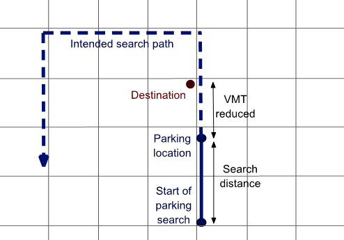
Source: FHWA. Figure 1. Illustration. Scarce parking can reduce vehicle miles traveled.
This street grid represents a series of city blocks. A solid line beginning near the bottom right extends upwards, turns into a dashed line, turns to the left, turns left again, and then extends downward. The starting point of the line is highlighted by a circle labeled “start of the parking search.” About the distance of two blocks upward, the line again is highlighted by a circle labeled “parking location.” The segment between the two circles is labeled “search distance.” The line now becomes dashed, but continues upward for a block, where a location is marked as the destination. This segment represents the distance by which VMT is reduced. The dashed line continues upward another block before turning left. It continues left for three blocks, and this distance is identified as the intended search path. The line again turns left and proceeds downward by about three grid boxes before ending in a downward-pointing arrow.
This report extends previous work that had relied on global positioning system (GPS) breadcrumb data to overcome the physical limitations of other research methods. Big data allows for a more comprehensive assessment of the extent and location of excess parking search.12, 13 The method also quantifies the measure of most direct policy interest—excess travel from cruising, rather than the proportion of drivers searching for parking. Along with documentation of the research strategy and Cruise Detector (i.e., the tool the study team developed to generate reliable estimates of cruising), this report includes case analyses from four U.S. cities. The cases illustrate a range of applications, such as identifying cruising hot spots by both time of day and location and assessing policy impacts. To assist cities in making parking policy and investment decisions, Cruise Detector is freely available and can be openly accessed. Purpose and ScopeThere are uncertainties and a lack of understanding of the full impact that parking cruising has on cities. There is also a paucity of understanding about the effectiveness of interventions. Recently funded studies include the direct precursor to this one,14 which provided a proof-of-concept to use GPS traces to identify a signature of cruising for parking. A related project15 deployed a set of wireless sensors throughout a study area that connects to devices in passing vehicles and identifies how often a vehicle passes the same point. Using information on how frequently and in what time frame a vehicle passes a certain point, an assessment is made regarding the extent of cruising in that area. The National Cooperative Highway Research Program has undertaken a recent review of dynamic curb management.16 Any number of departments of transportation have looked into the question as well, with many adopting performance pricing (designed to align parking demand with parking availability) and other strategies to combat problems that stem from parking shortages. The scope and purpose of this work is to develop a robust, freely available tool (i.e., Cruise Detector) that allows cities to understand the impact and extent of traffic generated by parking search and to test policy interventions. This report provides documentation on Cruise Detector and discusses its application. Cruise Detector can address the following questions (for the first four questions, specific examples of the analysis are provided in Chapter 3 of this report):
5 Adam Millard-Ball, Robert Hampshire, and Rachel Weinberger, “Parking Behaviour: The Curious Lack of Cruising for Parking in San Francisco,” Land Use Policy 91 (2020): 103918. [ Return to Note 5 ] 6 Gregory Barlow, Isaac Isukapati, Stephen Smith, Soumya Dey, Stephanie Dock, Benito Perez, Alex Pochowski “Measuring Cruising for Parking in Washington, DC Using Dense, Ubiquitous AVI Sensor Networks” 2018 TRB paper (https://trid.trb.org/view/1495676 ) [ Return to Note 6 ] 7 Eilene Zimmerman, “A Silver Bullet for Urban Traffic Problems,” CNN Money, April 29, 2011,http://money.cnn.com/2011/04/29/technology/streetline/. [ Return to Note 7 ] 8 Donald Shoup, “Cruising for Parking,” Transport Policy 13, no. 6 (2006), 479–486. [ Return to Note 8 ] 9 Steven Polzin, “Playing ‘Telephone’ with Transportation Data,” Planetizen, July 11, 2016. http://www.planetizen.com/node/87288/playing-telephone-transportation-data. [ Return to Note 9 ] 10 Paul Barter, “Is 30% of Traffic Actually Searching for Parking?,” Reinventing Parking, October 7, 2013,http://www.reinventingparking.org/2013/10/is-30-of-traffic-actually-searching-for.html. [ Return to Note 10 ] 11 Millard-Ball, Adam; Hampshire, Robert; and Weinberger, Rachel (2020), “Parking Behavior: The curious lack of cruising for parking in San Francisco.” Land Use Policy, 91: 103918. [ Return to Note 11 ] 12 Weinberger, Rachel; Millard-Ball, Adam; and Hampshire, R (2020) “Parking Search Caused Congestion: Where’s all the fuss?” Transportation Research Part C: Emerging Technologies vol 120. [ Return to Note 12 ] 13 Hampshire, R., Jordon, D., Akinbola, O., Richardson, K., Weinberger, R., Millard-Ball, A. & Karlin-Resnick, J., 2016. Analysis of Parking Search Behavior with Video from Naturalistic Driving. Transportation Research Record: Journal of the Transportation Research Board, 2543, pp.152–158. [ Return to Note 13 ] 14 Rachel Weinberger, Adam Millard-Ball, Robert Hampshire. 2016. Parking-Cruising Caused Congestion Final Report SBIR, USDOT Available at SSRN: https://ssrn.com/abstract=2906528. [ Return to Note 14 ] 15 Rapid Flow Technologies “Parking-Cruising Caused Congestion & Targeting Public Mitigation Investments” SBIR contract DTRT5715C10025. [ Return to Note 15 ] 16 NCHRP “Dynamic Curbside Management: Keeping pace with the new and emerging mobility and technology in the public right-of-way.” Web only https://www.trb.org/Publications/Blurbs/182823.aspx [ Return to Note 16 ] 17 Adam Millard-Ball, Rachel R. Weinberger, and Robert C. Hampshire, “The Shape of Cruising,” Findings (September 15, 2021), https://doi.org/10.32866/001c.28061. [ Return to Note 17 ] |
|
United States Department of Transportation - Federal Highway Administration |
||