Strengthening Linkages between Transportation Demand Management and Traffic ManagementContext 7. Managing Smart Parking and Considering Local Traffic ManagementParking is often considered separately from traffic flow, transportation choices, and mobility. However, the management of parking can impact traveler choice in significant ways. Dynamic parking information, dynamic parking pricing, and dynamic parking management can influence travel choices before and during a trip. Dynamic parking information, both real time and predictive availability, can influence travel choices. In San Francisco, CA, real-time parking information is coupled with traffic conditions to offer commuters in the US 101 corridor an en-route choice to either continue driving or divert to a transit station with available parking. The Messaging Infrastructure for Travel Time Estimates to a Network of Signs project, undertaken by the Partners for Advanced Transportation Technology program at the University of California, Berkeley, implemented variable message signs (VMSs) on US 101 in San Mateo County. The VMSs provide information about travel times to downtown San Francisco and compare those travel times to parking and diverting to transit, namely Caltrain services (figure 27). NYSDOT has provided real-time parking availability updates during major transit disruptions where a transit agency established temporary shuttle service from certain park-and-ride lots and NYSDOT wanted to encourage use of those lots. 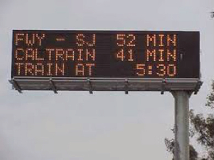 Figure 27. Photo. Variable message sign comparing driving the route with parking and taking transit.(53) (Source: California Department of Transportation). New York Department of Transportation Creates a Park-and-Ride Lot Map with Real-Time Space Availability The New York State Department of Transportation (NYSDOT), during the Amtrak New York Pennsylvania Station emergency repair work in July and August 2017, worked closely with the Metropolitan Transportation Authority (MTA) to support the transit agencies' efforts to provide alternative transit services given the absence of certain rail lines between Long Island and Manhattan. MTA informed NYSDOT about which park-and-ride lots MTA would provide temporary shuttle service to, and NYSDOT created an interactive park-and-ride lot map that showed real-time counts of the available number of parking spaces at those lots and real-time notifications when lots became full (figure 28). The purpose of NYSDOT's communication was to help travelers understand their alternative transit options and mitigate the amount of shift to single-occupancy vehicle travel during the repair work period. 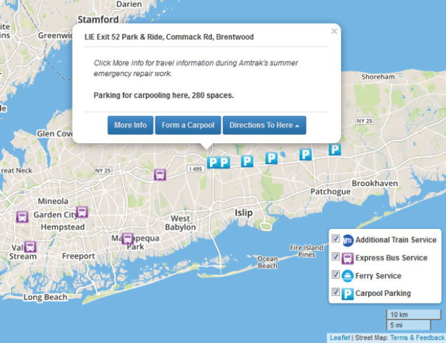 Figure 28. Screenshot. A map of park-and-ride lots with a pop-up box showing the number of available parking spaces.(54) (Sources Used: NYSDOT). Many new parking applications for handheld devices provide real-time parking availability information. In fact, Google Maps now shows predicted parking availability for 25 metro areas.(55) In the routing feature, Google Maps shows a green (available), yellow (limited), or red (constrained) P icon to indicate availability associated with the destination. Parking pricing and information can help manage scarce parking in high demand areas. Parking managers can set a parking price that is low enough to keep most spaces filled but high enough that the price deters enough people from parking to provide an open space to those who need to park and are willing to pay the cost. This strategy discourages people from driving around in search of an open space because enough spaces are open to those people who are willing to pay the price; people who are unwilling to pay the cost will not continue to search for an open space. The Seattle Department of Transportation installed smart parking meters for performance-based parking and an electronic parking guidance system. This, coupled with the e-Park Program, which provides real-time parking space availability for various parking garages in downtown Seattle, is designed to reduce cruising for on-street parking and help people find parking. The case study in this chapter shows how San Francisco, CA's parking pricing project is managing parking, but many other dynamic parking information applications help users plan and carry out their trip choices. Looking forward, with the advent of smart parking meters that can provide real-time information, there is an opportunity to explore how the information displayed by the smart meters can be used as another tool in the toolbox to manage the transportation system and provide travel choices. Active parking management has been included as part of the strategy response package when dealing with the impacts from construction activities, major transit disruptions, or even special events (some have been mentioned in case studies under other contexts in this compendium).
|
|
United States Department of Transportation - Federal Highway Administration |
||