Weather-Savvy Roads: Wyoming Department of Transportation Total Solar EclipsePrintable version [PDF 1.4 MB]
U.S. Department of Transportation FHWA-HOP-18-033 PATHFINDER CASE STUDY BackgroundThrough round 4 of Every Day Counts (EDC-4), the Weather-Savvy Roads effort deploys two distinct road weather management solutions that allow State and local agencies to be proactive in managing the surface transportation system ahead of and during adverse weather events: Pathfinder and Integrating Mobile Observations. This case study focuses on the implementation of Pathfinder by the Wyoming Department of Transportation (WYDOT) to help coordinate responses during a total solar eclipse on August 21, 2017. Pathfinder is a collaborative effort between the National Weather Service (NWS), State departments of transportation (DOTa), and State DOT support contractors who provide road weather information to share and translate weather forecasts into consistent transportation impact statements for the public. Pathfinder can play an important role on any major planned special event that could be impacted by changes in weather. The total solar eclipse that took place on August 21, 2017 was a highly publicized event by the news and media outlets for being the first since 1918 to have the total solar eclipse path crossing the entire United States, specifically from Oregon to South Carolina. Coordination between transportation agencies and the National Weather Service helped traffic managers better prepare for the major traffic impacts that were expected based on public enthusiasm about the eclipse, as evidenced by reports of hotels in the eclipse path being sold out for months in advance. Although the timing and path of the total solar eclipse was known and could help agencies predict traffic patterns for the event, this case study shows the value of continued coordination with the National Weather Service. The potential for clouds that would prevent crowds from viewing the eclipse could have significantly changed how impacts would occur on the transportation system, as people would have driven to a new location with better visibility the morning of the event. The total solar eclipse represents only one type of major event where increased collaboration between transportation agencies and the NWS can help present a collaborative and consistent response in order to anticipate traffic demand and present harmonious information to travelers. While traffic impacts of the total solar eclipse related mostly to cloud formation, other major outdoor events are more likely to be influenced by precipitation, or even dust storms or wildfires, which could impact the timing of the event or cause travelers to arrive or depart early. Examples of these large outdoor events include the Sturgis Motorcycle Rally in South Dakota or summer music festivals that take place around the country, often in rural areas. ApproachWYDOT and the Wyoming National Weather Service offices in Riverton and Cheyenne have collaborated since 2014 through Pathfinder. These efforts are often focused on winter weather events; however, Pathfinder is relevant for broader applications as well. Use of Pathfinder has allowed the formation of closer relationships and improved communication for action-oriented, proactive approaches to road weather management. The total solar eclipse path crossed the entire State of Wyoming, as shown in the image below from the Wyoming Office of Tourism website. Understanding the traffic impacts and potential disruptions caused by cloud cover, Pathfinder communication mechanisms were leveraged for an exchange of information between WYDOT and the NWS offices in Riverton and Cheyenne. Additionally, WYDOT 's onsite private sector support meteorologist, DayWeather, took the lead from WYDOT's perspective. 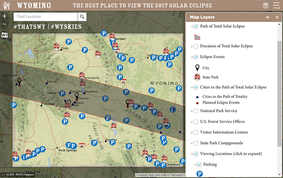
Figure 1: Wyoming visitor information website with layers to assist travelers wishing to view the total solar eclipse. (Source: http://eclipse.travelwyoming.com/) Specifically, DayWeather worked with the NWS on the forecast and participated in daily briefings with the press as WYDOT's voice. The previous page figure includes the Wyoming visitor information website with layers to assist travelers wishing to view the total solar eclipse. For the week prior to the event, the NWS provided daily morning updates via email about the August 21 weather forecast, including a statewide map of forecasted cloud conditions, as shown below. A daily call was also scheduled for a brief discussion of questions regarding the forecast or potential impacts. 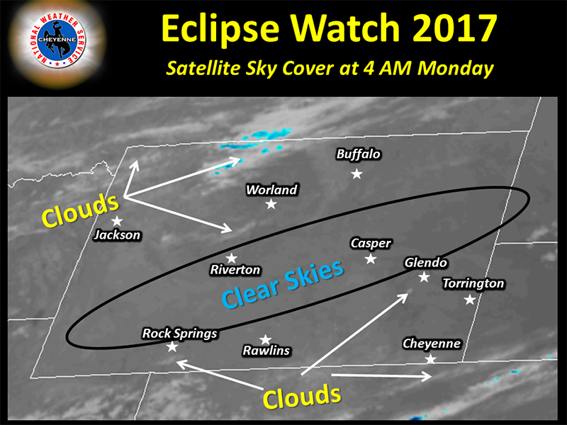
Figure 2. The National Weather Service provided daily forecasts to WYDOT via email. (Source: NWS) The week prior to the total eclipse event, the primary focus on the Pathfinder call with NWS, WYDOT, and WYDOT's onsite DayWeather meteorologist was the cover potential in Wyoming. Another focus was on neighboring States, given the potential for people to move from their current, intended location, should clouds form where they were positioned. It was noted that no wildfires currently existed in the region that would impact visibility. WYDOT and NWS staff also shared information regarding increases in traffic prior to the total solar eclipse. BEST PRACTICE: MAKE SURE THAT OTHER WEATHER EVENTS ARE STILL BEING MONITORED AND MANAGED, AS DONE WITH FIRE DANGER POTENTIAL DURING THE TOTAL SOLAR ECLIPSE. The NWS staff noted that the main difference between this total eclipse event and a typical weather event was that no message was scheduled to be posted on DMS about the eclipse. However, the fire danger potential was a major concern. High numbers of visitors driving into dry areas or even pulling off to the side of the road increase the chances of a fire being started, so extra precautions were made to make visitors aware of local fire restrictions. WYDOT displayed messages on DMS based on county emergency manager fire restrictions that were currently in effect, as opposed to meteorological forecasts (e.g., FIRE RESTRICTION IN EFFECT). On the date of the eclipse, WYDOT displayed messages on the DMS discouraging travelers from parking along the highway or within the right of way. WYDOT also issued proactive messaging through the Commercial Vehicle Operator Portal to make these users aware that heavy traffic would be expected during the total solar eclipse and that no oversize load permits would be issued. The NWS provided daily forecasts to WYDOT via email. BEST PRACTICE: DO NOT FORGET THE NECESSARY USERS OF THE ROAD LIKE FREIGHT, AND INCLUDE THEM IN THE EVENT MESSAGING. The traveling public was able to access information related to the total solar eclipse through several NWS, WYDOT, and Wyoming visitor information websites and social media platforms. The NWS created two-minute videos for YouTube on August 18 and August 20 that detailed the weather forecast for Wyoming during the total solar eclipse, which was then more widely distributed via social media—as seen on the WYDOT Facebook page below. The WYDOT traveler information website added a new page for the total solar eclipse to present general information and guide visitors to other websites for more information. Additionally, the WYDOT traveler information map was modified to include layers for total solar eclipse-related information, such as closures and expected road construction—as shown below. This information was also listed on a separate page of its website. Finally, the NWS offices posted daily forecast updates specific to the total solar eclipse event on their webpages, which also include side-by-side displays of Twitter feeds from the local NWS office and tweets with the hashtag #WyoRoad for drivers to report road conditions. As seen in an example below, two NWS YouTube videos were produced about the weather forecast for the day of the total solar eclipse and posted on the WYDOT Facebook page. In addition, the second figure includes the WYDOT traveler information map, which added a new layer to present information that would impact travelers during the total solar eclipse event. 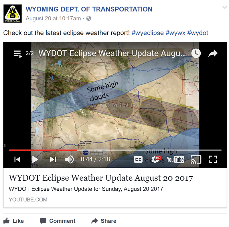
Figure 3: Two NWS YouTube videos were produced about the weather forecast for the day of the total solar eclipse and posted on the WYDOT Facebook page. (Source: WYDOT Fan Page on Facebook) 
Figure 4: The Wyoming Travel Information Map included a new layer to present information that would impact travelers during the total solar eclipse event. (Source: https://map.wyoroad.info/wtimap/index.html?show=Eclipse_Related_Construction) ImpactsAs expected, WYDOT reported major increases in traffic on the day of the total solar eclipse. Specifically, over 536,000 vehicles were counted on routes around the State, representing a 68 percent increase compared to the five-year average. Many routes experienced over a 100 percent increase, with one segment of I-25 seeing over a 400 percent increase in traffic over the five-year average. These increases in traffic volumes caused major backups around the State, as shown below. WYDOT staff expected to receive calls and complaints about congestion given the expected high volumes of traffic and resulting congestion. However, no complaints were received from the public. WYDOT believes the widespread and coordinated messaging by the DOT and other agencies prior to the total solar eclipse had a positive impact and helped increase awareness about the increased traffic. The governor's office and agency administrators are pleased with the proactive response that WYDOT took for the total solar eclipse, and WYDOT plans to repeat the Pathfinder approach for similar events in the future. Wyoming highways experienced high volumes of traffic from travelers coming to view the total solar eclipse, as seen below. 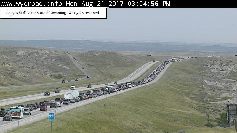
Figure 5: Wyoming highways experienced high volumes of traffic from travelers coming to view the total solar eclipse. (Source: WYDOT) For More InformationFHWAPaul Pisano, FHWA @dot.gov WYDOTVince Garcia, WYDOT |
|
United States Department of Transportation - Federal Highway Administration |
||