Weather-Savvy Roads: Using the National ITS Architecture for Implementing Weather-Savvy Roads - Integrating Mobile ObservationsPrintable version [PDF 2.0 MB]
U.S. Department of Transportation FHWA-HOP-18-031 Through round 4 of Every Day Counts (EDC-4), the Weather-Savvy Roads effort deploys two distinct road weather management solutions—Pathfinder and Integrating Mobile Observations (IMO)—that allow State and local agencies to proactively manage the surface transportation system ahead of and during adverse weather events. IMO promotes the collection of mobile weather, road, and vehicle data from agency fleets to improve situational awareness of road conditions. As more State Departments of Transportation (DOTs) begin to consider vehicle-based data integration, it becomes increasingly important to have standardized installations, common lexicons, and normalized data formats to maximize benefits to the State and the larger community. To achieve this, State DOTs can utilize the USDOT Intelligent Transportation Systems (ITS) Joint Program Office (ITS) National ITS Architecture tools. This factsheet shares high-level information on using the National ITS Architecture to support the systems engineering process necessary for IMO projects. What Is the National ITS Architecture?The National ITS Architecture is a common framework for transportation practitioners looking to design and deploy ITS in their jurisdictions. For over 20 years, the architecture has continued to evolve to meet changing transportation-related needs. The most recent version of the architecture (version 8)—as shown in the figure below—is referred to as the Architecture References for Cooperative and Intelligent Transportation (ARC-IT). It is a combination of the traditional architecture and the Connected Vehicle Reference Implementation Architecture (CVRIA). This resulting reference architecture provides a common language for planners and engineers to use a systems engineering process for creating and implementing regional and project-based ITS architectures. ARC-IT consists of four views: enterprise, functional, physical, and communications. For more information, visit http://local.iteris.com/arc-it/index.html 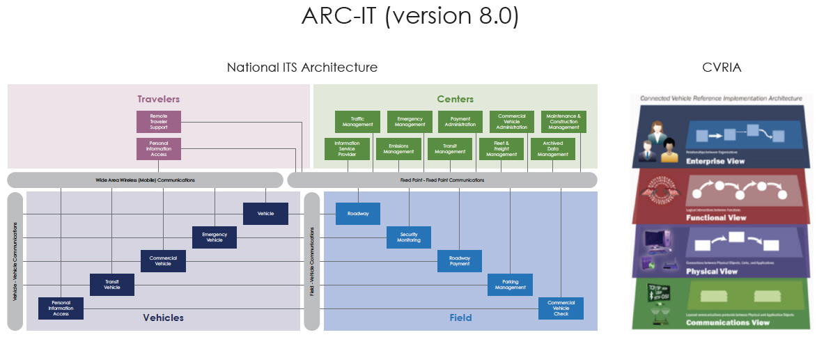
Figure 1: ARC-IT (version 8.0) flow charts. (Source: Adapted from ITS ITS) How It WorksThe steps to share IMO data with the Weather Data Environment (WxDE) are shown and described below. ARC-IT includes two software tools that support tasks on the left side of the Systems Engineering Vee Diagram, found below. This includes high-level system design and project-specific deployment. Regional Architecture Development for Intelligent Transportation (RAD-IT), is focused on the design steps of the Vee Diagram. It is used for regional planning and operations concepts to develop high-level enterprise and physical views. It is a replacement for the previous Turbo Architecture and has a more modern interface. System Engineering Tool for Intelligent Transportation (SET-IT), is project-focused and graphically defines the functionality within subsystems and the interfaces between them. 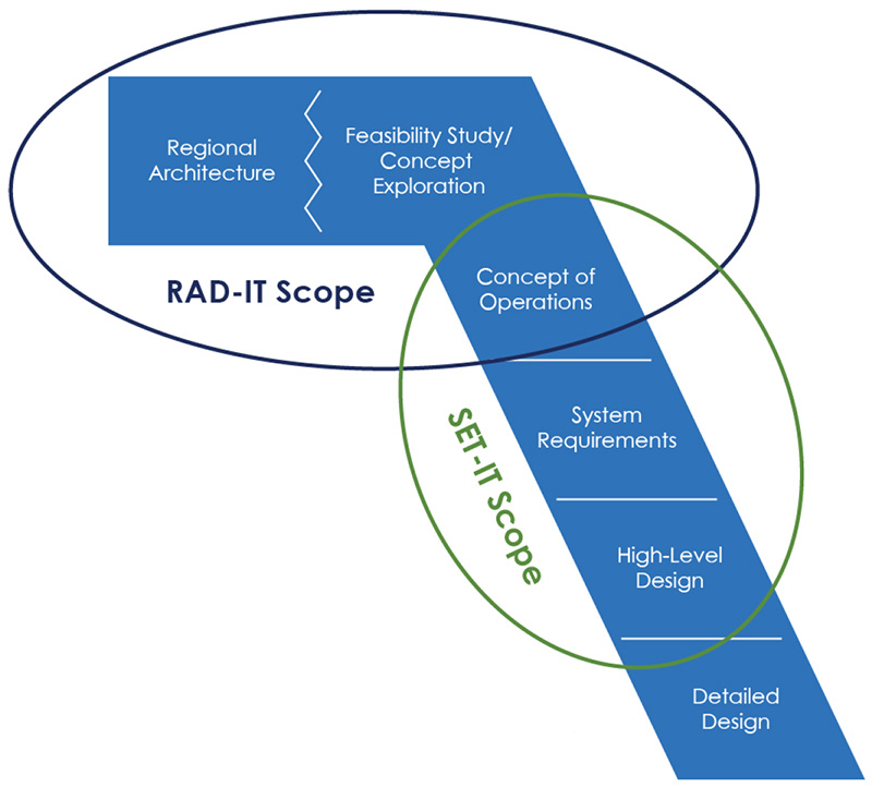
Figure 2: RAD-IT Scope and SET-IT Scope. (Source: ITS ITS) For Weather-Savvy Roads IMO-related efforts, practitioners are likely to use the SET-IT tool. SET-IT supports the development of detailed project ITS architectures and systems engineering documentation. It includes service packages (i.e., templates) for IMO-related topics under four service areas.
For more information on service packages, visit http://local.iteris.com/arc-it/html/servicepackages/servicepackages-areaspsort.html. Each service package includes a set of physical objects, functional objects, and information flows (see table below) and can be customized to best meet regional needs. An example service package is shown below (http://local.iteris.com/arc-it/html/servicepackages/sp40.html#tab-3).
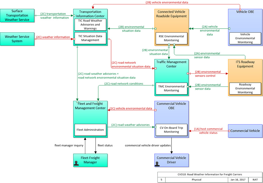
Figure 3: Vehicle environmental data flow chart. (Source: ITS ITS) Why Use It?Benefits of Standardization. Within each service package, interfaces can be standardized to enable data sharing with both internal system components (e.g., central servers) and outside entities like the WxDE. Using these data definitions and communications standards enables the use of commonly available tools resulting in more cost effective solutions. It also makes collaboration with other teams more efficient. Flexibility in Communication Technology. SET-IT is flexible with respect to wireless vehicle connectivity. It fully supports cellular, Wi-Fi, satellite, DSRC, and radio. Common Lexicon. SET-IT is used to organize the data flows and protections between entities in a graphical environment. Doing this with SET-IT helps quickly produce documents that use the National Architecture terminology, assisting in collaborating with other groups and vendors in a common lexicon. Next StepsFor stakeholders interested in taking advantage of the benefits of ARC-IT and its software tools, free training and software downloads are available. For more information, contact Ray Murphy (Ray.Murphy@dot.gov) or review the following resources.
For additional information, please contact: Gabriel Guevara | |||||||||||||||||||||||
|
United States Department of Transportation - Federal Highway Administration |
||