Construction of e-Permit/VWS Model Sites: Project Summary Report
Laurel, Kentucky and Unicoi, Tennessee
Chapter 3. Inventory and Assessment of Target Sites (Task 2)
This chapter provides a Site Report for the two model sites, one in Laurel County, KY, the other in Unicoi County, TN. The purpose of the Site Reports was to inventory, analyze, and assess the existing roadside technology present at each weigh station, with an eye to identifying what additional equipment is required to successfully conduct the e-Permit/VWS test at both sites. The results of the assessment informed the Test Plan and helped the team properly requisition a VWS configuration. The remainder of this chapter consists of two sections. The first summarizes the Site Report for the Laurel County, KY site. The second summarizes the Site Report for the Unicoi County, TN site.
Kentucky
Location
Figure 3 highlights the location of the Kentucky VWS (see the marker labeled "Laurel County VWS" on U.S. 25). The site is in Laurel County just north of the following address:
8325 South U.S. 25
Corbin, Kentucky
U.S. 25 parallels I-75 to the east and is a known commercial vehicle bypass route around existing northbound weigh scales on I-75. U.S. 25 passes by two area schools and multiple residential areas, raising safety concerns due to high truck volume.
The intent of locating the VWS at this site is to identify Kentucky-bound (northbound) truck traffic attempting to bypass the I-75 northbound scales.
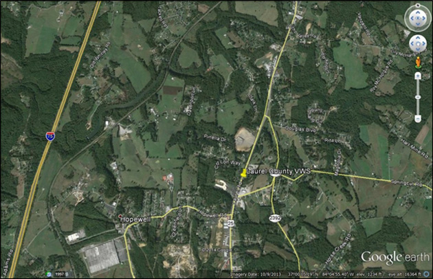 Figure 3. Map. Location of Laurel County virtual weigh station.
(Source: Google Earth. (Google and the Google logo are registered trademarks of Google Inc., used with permission.))
Figure 3. Map. Location of Laurel County virtual weigh station.
(Source: Google Earth. (Google and the Google logo are registered trademarks of Google Inc., used with permission.))
Existing Conditions
U.S. 25 is a two-lane road with a 7-foot, non-raised median and a 10-foot shoulder in the northbound direction. A guardrail is present next to this shoulder. The narrowness of the shoulder and the presence of the guardrail will require enforcement officers to escort trucks to a safe pull-off area somewhere downstream of the VWS.
There is a mix of commercial and noncommercial vehicles at this site, though most traffic appears to be noncommercial. The site did not have any existing VWS equipment to evaluate during the site visit.
Proposed Site Improvements
Since there is no existing roadside equipment at the Laurel County site, this project required installation of a complete system. The technology and hardware to be deployed includes:
- Smart Roadside cabinet with all electronics.
- Automated License Plate Reader (ALPR).
- Automated U.S. Department of Transportation (USDOT) Number Reader (AUNR).
- Overview Camera (OVC).
- Weigh-in-motion (WIM).
The preference for communications was to run a hard-wired connection into the roadside cabinet. The intent is to have officers in mobile units access the system using laptops with cellular data modems. From the laptop, the officers will be able to view a live summary of all commercial vehicles as they move northbound along U.S. 25.
Figure 4 presents the proposed layout of the loops and roadside equipment. The VWS envisioned for the Kentucky test site would involve WIM and portable scales for vehicle measurement; USDOT number and license plate readers for vehicle identification; and screening based on CVIEW/SAFER/ITD (or an equivalent Kentucky system) combined with Web portal access for mobile enforcement units. For the WIM, further testing was recommended to test pavement roughness against appropriate standards due to current pavement conditions that could impact the accuracy of WIM readings. The site will not utilize transponders for vehicle identification.
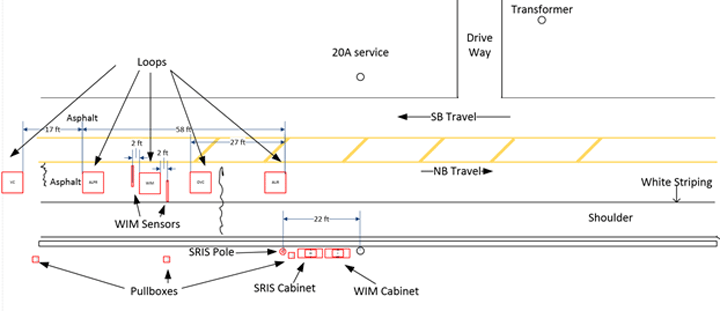 Figure 4. Diagram. Proposed layout for roadside screening equipment.
(Source: FHWA.)
Figure 4. Diagram. Proposed layout for roadside screening equipment.
(Source: FHWA.)
The Electronic Permitting/Virtual Weigh Station Architecture identified several "best practice" technologies based on a review of commercial motor vehicle (CMV) inspection sites around the country.3 Table 1 compares these best practices to the proposed solutions at the Laurel County VWS.
Table 1. Relationship of proposed County systems to "best practice" technologies.
| "Best Practice" Technologies |
Laurel County Site Technology/Functionality |
| Mainline or ramp-based WIM. |
Mainline WIM. |
Multiple CMV identification technologies:
- 915 MHz transponder-based.
- USDOT number reader.
- License plate reader.
- Future: Universal Truck ID.
|
USDOT number reader, license plate reader, overhead camera for visual verification. |
| Local computing resources to execute screening processes and access databases. |
Hard-wired Internet connection through roadside cabinet will allow for real-time screening/display on enforcement staff's laptops. |
| Connectivity to State back-office systems. |
Dependent on Kentucky installing appropriate hardware and security protocols. |
| Connectivity to databases in other States. |
Dependent on those States providing access to their systems. |
| Automatically generated alerts for enforcement personnel. |
SRIS system accessible through Web portal on officers' laptops—will provide screening decisions in real time. |
| In-cab notifications for transponder-equipped vehicles. |
N/A—CMVs will be directed to safe pull-off area by mobile enforcement units. |
| Fixed or dynamic message signs for non-equipped trucks. |
N/A—CMVs will be directed to safe pull-off area by mobile enforcement units. |
| Future: Inputs from Wireless Roadside Inspection Technologies. |
N/A—Functionality is not yet available but there are no obvious interoperability issues. |
Tennessee
Location
The Tennessee VWS is located on Interstate 26 at milepost 0 in Unicoi County, south of Johnson City in eastern Tennessee (see marker labeled "Unicoi" in figure 5). The intent of locating the VWS at this site is to monitor the northbound traffic coming into Tennessee from North Carolina.
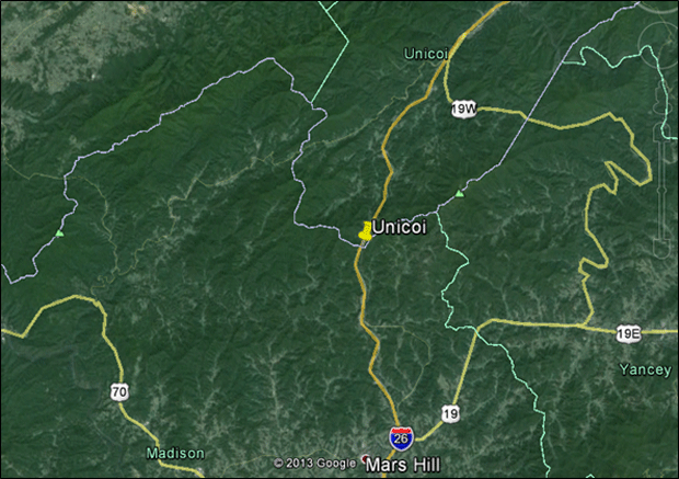 Figure 5. Map. Location of Unicoi county virtual weigh station.
(Source: Google Earth. (Google and the Google logo are registered trademarks of Google Inc., used with permission.))
Figure 5. Map. Location of Unicoi county virtual weigh station.
(Source: Google Earth. (Google and the Google logo are registered trademarks of Google Inc., used with permission.))
Existing Conditions
The proposed VWS site currently has a ramp and parking area for trucks. Trucks are directed by overhead signs on I-26 to pull off the mainline as they approach the site. After entering the ramp, they pass over the existing (nonfunctional) WIM sensors. From there, they may continue through the site and rejoin I-26 or park in provided truck spaces on site, for example if a mobile enforcement unit determines that an inspection is required. This site is not typically staffed and enforcement was not being conducted during the site visit. This means that commercial vehicle traffic from North Carolina can pass through Tennessee using I-26 and never pass by a functioning weigh scale.
The ramp appears to be in good condition except for three cracks. The ramp is relatively low speed and trucks are slowing down as they approach the entry of the site (observed speed of approximately 35 miles per hour). However, the condition of the VWS entry ramp (cracks and an abrupt transition from asphalt to concrete) may impact the accuracy of WIM readings at the Unicoi VWS. This may be an issue if road conditions at the site do not meet American Society for Testing and Materials (ASTM) standards for smoothness.
Figure 6 provides a view of the ramp looking northward.
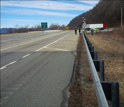 Figure 6. Photo. Tennessee virtual weigh station ramp overview.
(Source: FHWA.)
Figure 6. Photo. Tennessee virtual weigh station ramp overview.
(Source: FHWA.)
The current state of the WIM cabinet and equipment could not be evaluated and it is not known if the equipment works or not. The site also has two equipment poles, each with a camera. One of the poles had what appeared to be a Wi-Fi antenna.
Proposed Site Improvements
Even though the site has existing equipment, it is not recommended that this equipment be reused. The WIM cabinet was not powered and had clear signs of missing equipment. The existing WIM system has not been operational for some time and the team was unable to determine the functionality of current equipment.
The VWS envisioned for the Unicoi test site would involve ramp WIM and portable scales for vehicle measurement; USDOT number and license plate readers for vehicle identification with visual verification provided by way of overhead cameras; and screening based on CVIEW/SAFER/ITD (or an equivalent Tennessee system) using screening algorithms combined with Web portal access for mobile enforcement units. It will not utilize transponders for CMV identification. Drivers will be directed to pull into the site by existing overhead signs on the mainline and will be guided on the site by enforcement personnel.
Table 2 compares "best practice" technologies to the proposed solutions at the Unicoi VWS.(3)
Table 2. Relationship of proposed Unicoi County systems to "best practice" technologies.
| "Best Practice" Technologies |
Unicoi Site Technology/Functionality |
| Mainline or ramp-based WIM |
Ramp WIM. |
Multiple CMV identification technologies:
- 915 MHz transponder-based.
- USDOT number reader.
- License plate reader.
- Future: Universal Truck ID.
|
USDOT number reader, license plate reader, overhead camera for visual verification. |
| Local computing resources to execute screening processes and access databases. |
Hard-wired Internet connection through roadside cabinet will allow for real-time screening/display on enforcement staff's laptops. |
| Connectivity to State back-office systems. |
Dependent on Tennessee installing appropriate hardware and security protocols. |
| Connectivity to databases in other States. |
Dependent on those States providing access to their systems. |
| Automatically generated alerts for enforcement personnel. |
Smart Roadside Initiative (SRI) System accessible through web portal on officers' laptops—will provide screening decisions in real time. |
| In-cab notifications for transponder-equipped vehicles. |
N/A—CMVs will be directed to enter site by way of overhead signs. |
| Fixed or dynamic message signs for non-equipped trucks. |
Fixed signs. |
| Future: Inputs from Wireless Roadside Inspection Technologies. |
N/A—Functionality is not yet available but there are no obvious interoperability issues. |