Recurring Traffic Bottlenecks: A Primer
Focus on Low-Cost Operational Improvements (Fourth Edition)
Appendix C. Case Studies
This appendix presents a series of case studies on localized bottleneck reduction strategies deployed by agencies across the United States. These case studies are summarized in the list below and presented in full in the following figures.
- City of Arvada, Colorado—Problem: Train traffic routinely halts vehicular traffic. Solution: Grade separation.
- Minneapolis-St. Paul, Minnesota—Results of the 2001 study of ramp metering effectiveness.
- Austin, Texas—Problem: Three lanes squeeze down to two. Solution: Restripe to reclaim "missing lane."
- Pittsburgh Pennsylvania—Problem: Inadequate acceleration lanes. Solution: Convert shoulder to full-use lane.
- Washington State DOT—Statewide "Moving Washington" Program. Problem: How to make the most of a transportation budget. Solution: Use performance measures as a strong decision metric.
Additional case studies can be found on the FHWA Localized Bottleneck Reduction Program web site.
Colorado
Location—City of Arvada, Colorado
Grandview Avenue, and railroad, at Wadsworth Boulevard.
Problem—Train traffic routinely halts vehicular traffic and poses safety problems for emergency responses
Train traffic (especially) and vehicles on Grandview Avenue would routinely block traffic on Wadsworth Boulevard. Emergency response in the vicinity was complicated and expensive, requiring two calls at all times—one for each side of the tracks—in the event that a train would come through.
Figure 20. Traffic backed up on northbound Wadsworth prior to the project. Restaurant (blue roof) had to be relocated.
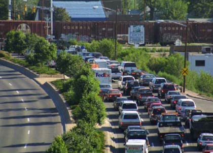
(Source: Federal Highway Administration.)
Figure 21. The new Grandview Bridge, "Gateway to Olde Arvada."
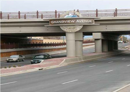
(Source: Federal Highway Administration.)
Solution—Grade Separation
Wadsworth Boulevard was lowered 25 feet and now passes under Grandview Avenue and the Northern Railroad. A wide median "gap" on Grandview Avenue will accommodate the future "Gold Line" (planned) commuter rail line. A pedestrian plaza (above, on Grandview) was also accommodated. The $32 million project ran from October 2006 to December 2008. Ironically, an early 1900s trolley originally ran on Wadsworth underneath Grandview, but was removed in the 1950s, and Wadsworth Boulevard was raised, creating the precursor to the subject problem; so the re-lowering of Wadsworth Boulevard was merely a full-circle remediation of this intersection. Much of the cost was given to easing the impact of the project. A local restaurant next to Grandview Avenue was relocated from the footprint of the project. The driving public felt minimum inconvenience during the project; roadway traffic on Wadsworth Boulevard was detoured to a temporary alignment which allowed three lanes in each direction to pass the project. Railroad traffic was detoured to a "shoofly" (i.e., temporary railroad bridge). The underpass now serves as a "Gateway to Olde Arvada" (i.e., downtown) and a shining success story for the Colorado Department of Transportation (CDOT).
Lesson Learned
While $32 million and two years of construction may not seem the conventional definition of a "low cost, low impact" remediation, don't tell that to the City of Arvada and CDOT. The highly visible, publicly praised project was an unequivocal success in terms of solving a long-standing bottleneck problem ($19 million in Federal and State formula funds, $6 million from Arvada, and most of the remainder from Federal earmarks)!
Minnesota
Location—Minneapolis-St. Paul, Minnesota
Results of 2001 study of Ramp Metering
Effectiveness—In September 2000, all 430 ramp meters were turned off in the Twin Cities region in response to a mandate from the Minnesota State Legislature, following citizen complaints and questions raised by State Senator Dick Day; namely, do ramp meters work?
Figure 22. A ramp meter.
(Source: Federal Highway Administration.)
Objectives
- To fully explore effectiveness of ramp meters; meter "wait time" was also a key concern.
- To respond to citizen's questions and identify public perception of ramp metering.
- To involve a citizens advisory board to ensure credibility of the study.
Process and Findings
Cambridge Systematics was hired by MnDOT to perform the study, inclusive of getting pre-study data and incorporating any/all citizen input and ensuring a transparent process. Five weeks of "before" speed and crash data was recorded. The ramps were shut off for a pre-determined "transition" period and then turned back on for five weeks of "after" data gathering.
- Without meters:
- A 9 percent reduction in freeway volume; a 22 percent increase in travel times; a 26 percent increase in crashes (even after adjusting for prior seasonal rates).
- Most survey respondents believed traffic had worsened.
- After the study: 20 percent wanted meters left off; 10 percent want them "returned"; 70 percent want modifications.
Lessons Learned/Changes Implemented
- Neither "all" nor "nothing" was deemed best, but a new, modified approach was adopted:
- Fewer meters than before the study were turned back on (location candidacy was tightened and superfluous meters were removed).
- Hereafter, meters would wait no more than 4 minutes on local ramps or 2 minutes on freeway-to-freeway ramps.
- Vehicles queued back to city streets will be "released" (meters temporarily shut off) and meter operation will better-respond to congestion-only times via improved use of detectors.
Texas
Location—Austin, Texas
Northbound U.S. 183 from the Missouri and Pacific (MOPAC) Freeway to Great Hills Trail
Problem—Three lanes squeeze down to two
Figure 23. The sign for U.S. 183.

(Source: Federal Highway Administration.)
Solution—Restripe to claim "missing lane"
In November 2009, The Texas Department of Transportation (TxDOT) restriped the outside lane of northbound U.S. 183 and extended it beyond the Braker Lane exit.
The restriping did not affect the direct-connect ramp from the Missouri and Pacific freeway (MOPAC) to U.S. 183. "The footprint of U.S. 183 (remains) the same, but the new striping allows more cars to flow through, and eases evening congestion."
Cost—$55,000 and "a few nights' work"
Lessons Learned
The project was generally so well received that one citizen commented: "If it was this easy and this cheap, what took you so long?" And since the project was completed in November 2009, the tone of comments received by TxDOT have generally remained along those lines.
Pennsylvania
Location—Pittsburgh, Pennsylvania
I–279 at the Carnegie Interchange in Pittsburgh, Pennsylvania.
Problem—Inadequate acceleration lane
The existing slip on-ramp from Academy Street onto southbound I–279 has been a major traffic bottleneck and high accident location for many years. The on-ramp did not have an acceleration lane to allow for the smooth merging of traffic entering the freeway. Thus, vehicles often came to a complete stop to wait for an acceptable gap in traffic. With high Interstate traffic volumes and typically high travel speeds, the existing configuration created an unsafe and inefficient merge condition. Accident rates at this location were high and traffic queues would regularly back-up on the ramp. Mainline traffic would also be slowed by driver uncertainty and friction created by the interchange. To further compound the problem, the freeway has two lanes in the southbound direction at the ramp location but widens to three lanes further downstream, making the ramp location even more evident as a bottleneck.
Solution—Convert shoulder to full-use lane
Traditional improvements such as widening the freeway were infeasible economically because they would require widening the bridge piers for the overhead road. Therefore, the Pennsylvania Department of Transportation (PennDOT) and the Federal Highway Administration (FHWA) devised a low-cost solution which involves converting the existing right shoulder into a third freeway lane and re-striping the existing ramp to allow oncoming traffic to continue onto the freeway without stopping. The added third lane will be extended to tie in with the existing third lane of mainline traffic 800 feet downstream. The work will entail milling and resurfacing the shoulder to accommodate traffic, re-striping the ramp and mainline, and making minor changes to the ramp taper, with an estimated cost of $250,000. The project will completely remove the merge condition and bottleneck at the freeway entrance and eliminate ramp and mainline queues. Although the conversion of the shoulder will result in no shoulder presence for the length of the new lane segment, it was determined that a design exception was appropriate given the significant operational and safety benefits to result from the change. The work was scheduled to be completed in October 2007.
Lessons Learned
This project demonstrates that low-cost, low-impact bottleneck improvements can make significant improvements in traffic flow.
Washington
Statewide Moving Washington Program
Moving Washington (initiated in 2008) is the Governor's 10-year, three-pronged strategy to combat congestion. It aims to 1) operate efficiently that which exists; 2) manage travel demand; and 3) add capacity, which itself is a three-tiered program:
- Tier 1 jobs are immediate, low-cost, operational fixes.
- Tier 2 jobs are medium-cost design-builds.
- Tier 3 jobs are major future-planned system upgrades.
Problem—How to make the most of a transportation budget
Using a combination of annual and "earmarked" State gas taxes, plus the normal Federal allocations, Washington uses a system of performance goals and measures to justify, warrant, and select candidate projects. Elected officials are educated to "buy in" to use metrics—and less so political means—to determine projects. Achieving "maximum throughput" is the defining target for the basis for congestion relief decisions. "The annual percent of system that is congested" is defined as the percent of lane miles that are routinely less than 70 percent of posted speeds. (For more information see the Washington State DOT web site.)
Figure 24. Moving Washington logo.
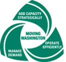
(Source: Washington State Department of Transportation.)
Solution—Use Performance measures as a strong decision metric
Travel times and reliability are important measures to commuters and also to the Washington State Department of Transportation (WSDOT) in determining candidate projects. "WSDOT aims to provide and maintain a system that yields the most productivity or efficiency, rather than focus on providing a system that is free flowing, but in which fewer vehicles can pass through a segment during peaks." Maximum throughput is achieved when vehicles travel at speeds between 42 and 51 miles per hour (mph) (roughly 70 percent to 85 percent of 60 mph) because more vehicles can pass a segment than would be at posted speeds. This happens because at the lesser speeds, vehicle headways can condense more safely. WSDOT measures "highway segments" (e.g., similar lane congruencies, geometrics and adjacent land use) and targets the inefficient ones. Stand-alone segments are candidates for Tier 1 and Tier 2 projects (see above) and "linked" segments become candidates for Tier 3, all things considered.
Lessons Learned
In the 2000s, several "capacity expansion projects" (a WSDOT catch-all term for bottlenecks, etc.) provide examples of WSDOT's process.
- I–405—Adding either one or two lanes where necessary to reduce local congestion.
- I–405 'South Bellevue'—Adding general purpose northbound and southbound lanes, and a southbound high occupancy vehicle (HOV) lane.
- SR 518—Adding a third eastbound lane between I–5 and SeaTac Airport to relieve a long-suffering recurrent problem.
- I–205 at Mill Plain exit and 112th connector—Creating a direct connection to NE 112th Avenue from the northbound I–205 off-ramp to Mill Plain Boulevard, which addressed safety problems too.