Best Practices in Permitting of Oversize and Overweight Vehicles: Final Report
CHAPTER 8: REVIEW OF OVERSIZE/OVERWEIGHT PERMITTING VENDOR SYSTEMS
This section of the report highlights the oversize/overweight (OS/OW) permitting vendor system available in the market today.
Bentley Systems
Bentley Systems provides an OS/OW permitting software package called SUPERLOAD.4 SUPERLOAD functionality includes:
- Routing software that conducts real-time route analysis that ensures that the permit request is compliant with the State-specified thresholds on particular routes.
- Automated issuance of OS/OWpermits.
- A roadway restriction software application that enables a State to enter permanent and temporary route restrictions and update the routing software as notice of route restrictions are received and processed by a State permitting office.
- A live-load bridge analysis software application that enables real-time analysis of the specific permit vehicle configuration over each structure. The analysis is based on State-established thresholds and temporary and/or permanent route restrictions.
The Bentley system is designed to include local roads on a permit route if State business rules provide for this. The Bentley system is currently being used by the State of Maryland to issue local permits for the city of Baltimore as well as permits for the Port of Baltimore.
Additional functional features include:
- Tracking open permits and notifying permit holders of changes in permit status.
- Electronic payments – credit cards, electronic funds transfer, escrow accounts.
- Library function that stores company data, power unit and trailer configuration information, and previously issued permits and routes.
Several screen shots from the Bentley system are shown below. The first shows the Maryland One (MD1) application screen that carriers must complete to establish an account with the State. The second shows the results of a requested permit route that was not approved due to an existing bridge height route restriction. The system generated a notice to the applicant explaining the restriction and a map showing the location of the restriction, in this case a bridge that did not meet State thresholds for the requested OS/OW load movement. The third screen shot is historical routing data, showing a heat map of where the permitted trips had occurred. This historical routing data can be filtered for a variety of factors, such as timeframe and vehicle configurations.
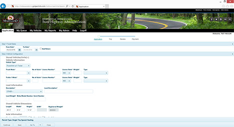
Figure 3. Maryland One automated oversize/overweight permit application screen shot.
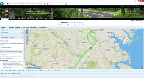
Figure 4. Real-time route analysis screen shot.
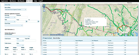
Figure 5. Historical route library function screen shot.
Bentley Systems has also developed an innovative product called GotPermits. As noted on the Bentley webpage, GotPermits enables a carrier to submit a permit application for a multistate route. The application is entered into a user interface that in turn links to all States participating in GotPermits. The permit application is processed in compliance with each State's requirements and if the requested load meets each State's requirements and is within thresholds, GotPermits then issues the carrier permits for each of the States along the requested route. A screen shot of the historical route library function in GotPermits is shown above in Figure 5.
The Bentley webpage provides the following information on specific GotPermits functionality:
- "Maintain information about your entire fleet and use that information to request permits from all the agencies supported by the site
- Make requests for more than one agency via a single application process, addressing all permit and routing requirements
- Perform your own routing using a variety of different routing techniques
- Perform your own job/bid reviews without any cost
- Track your job numbers with specific agency permits
- Request a variety of reports to assist with your accounting and reconciliation
- Pay for any permit with an escrow account or credit card
- Receive immediate, system issued permits for most permit requests" 5
The GotPermits system architecture is shown in Figure 6. As the figure shows, the user interface is linked to each State system and processes the permit application according to each State's requirements. An example of how this works is shown in Figure 7, which shows how GotPermits consolidates the information required by each State from the carrier's application so the permits can be processed and issued in accordance with State requirements and thresholds.
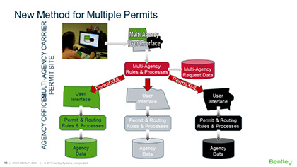
Figure 6. Bentley Systems GotPermits system architecture.
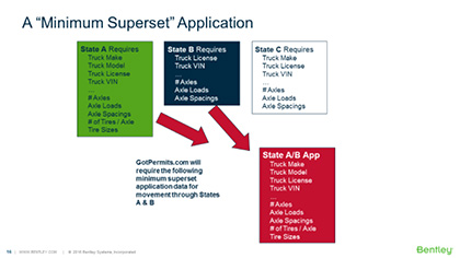
Figure 7. GotPermits permit application data consolidation.
ProMiles Software Development Corporation
ProMiles Software Development Corporation (PSDC) is one of the two primary vendors providing States with automated OS/OW permit systems. The PSDC solution consists of a commercial off the shelf (COTS) system that was originally developed for Texas. PSDC has utilized this same system as the basis for each of the other nine systems it has developed. PSDC customizes its system to meet the exact needs of the client and does not require the client to change their processes to fit the system. Because of this, each State or province utilizes a separate code base. The code in each code base is very similar, but has been modified to meet the needs of the State or province. Table 3 summarizes the system components of the ProMiles system:
| Component Name | Description |
|---|---|
Web Interface |
The Web Interface is a .NET web-based application that provides the End User functionality for all system interfaces except mapping. |
Route Server |
The Route Server is a .NET application that provides routing and route endpoint location lookup for the system. |
Tile Server |
The Tile Server is a .NET application that provides the base mapping and the restriction mapping for the system. |
Runtime Files |
The Runtime Files are binary files that the Route and Tile Servers utilize to route trips and create maps. |
Runtime File Creation Software |
This software component consists of .NET applications that together take GIS datasets built by the GIS Import Application to make the Runtime Files utilized by the Route and Tile Servers. |
Drag Route Server |
The Drag Route Server is a .NET application that provides support for the Drag Route function. Once the Drag Route Server has been set up with a session, it interacts directly with the user. |
GIS Import Application |
This software pulls in the Department GIS data, and GIS data from other sources, and combines it into a single GIS dataset. PSDC GIS Specialists ensure the data is routable and correct. |
Aerial Imagery/Topo Maps/Etc. |
These are aerial imagery base tiles and other base tiles provided by the State, province, or other services. |
Integrated Bridge Analysis |
The Integrated Bridge Analysis is a port of Alberta Transportation's FORTRAN or similar Moment Comparison tool into the OS/OW application. |
External Bridge Analyses |
External Bridge Analyses are optional integrations with external Bridge Analysis Systems. |
Alberta Transportation Bridge Rating Data Source(s) |
Bridge Rating Data Sources are State or provincial DOT systems that provide bridge rating data to both internal and external Bridge Analysis Systems. |
Database Tables |
The database is a standard Microsoft SQL Server relational database that stores all data except the Runtime Files. |
Restriction Manager Application |
The Restriction Manager Application is a web-based application that provides Agency Users access to the OS/OW routing restrictions. |
Restriction Data Import Program |
This software component will consist of one or more .NET applications that will import the restriction data and record it in the Restriction Database. |
Restriction Data Sources |
Restriction data sources are travel alert systems that provide real-time data for OS/OW restrictions. |
Reroute Notification Application |
The Reroute Notification Application is a .NET application that runs as a scheduled task. This application identifies active permits that violate restrictions and sends notifications to the Department and to the customer. |
Credit Card Payment Interface |
This interface in integrated with a credit card processing system. |
CVIEW/SAFER |
This is an integration with SAFER data using either the jurisdiction's CVIEW system or a file from the USDOT SAFER database. The integration includes carrier and credential information pulled from these sources as well as permit data pushed to these sources. |
IFTA/IRP, Other Jurisdiction Data Sources |
This is integrated with various State systems to obtain carrier and credential information for these systems and to push permit data to these systems. |
Email/Fax Services |
The Email/Fax Services are either provided by the State or province or by PSDC for delivering communication. |
The PSDC system has the capability to generate maps that show all State and local roads in a State using GIS data. The decision to include local roads on State road and individual permit route maps is up to the State or province.
PSDC's OS/OW Permit and Routing Systems are designed with a flexible Permit Definition Interface. This easy to use interface allows Administrative Users to create new Permit Definitions, deactivate Permit Definitions, and change existing Permit Definitions without any programming. All Permit Definition configuration settings are stored in the database. The permits can have very complicated fee calculation methods that can be changed by authorized users without programming. PSDC's systems utilize this web interface to define permits within the system instead of using a business rule middleware system. The permit definition fields are defined in Table 4.
| Item | Description |
|||||||||||||||||
|---|---|---|---|---|---|---|---|---|---|---|---|---|---|---|---|---|---|---|
| Permit Name | The name of the permit that is displayed on the screen when selecting the permit type. |
|||||||||||||||||
| Printed name | The name printed on the permit. This allows a template to be used for multiple, similar permit types. |
|||||||||||||||||
| Template Number | The template number that is used for the permit |
|||||||||||||||||
Permit description |
A description of the permit. This description will not be displayed to the end user. |
|||||||||||||||||
Duration |
How long the permit is valid. This can be expressed in days, months, or years, or can be fixed start and end dates. |
|||||||||||||||||
Load description |
If the load description is fixed or is one of a set of options. |
|||||||||||||||||
Commodity type |
If the commodity type is fixed or is one of a set of options. |
|||||||||||||||||
Number of days the permit can be ordered prior to effective date |
Number of days in advance a permit can be ordered. |
|||||||||||||||||
Permit end date can be changed flag |
Flag stating whether the user can shorten the duration length of the permit. This is used in Texas for routed permits so that a load can be completed before a restriction starts. |
|||||||||||||||||
Effective date and final date |
The dates the permit type becomes valid or the date the permit type retires. Allows for the creation of a permit type in the system before it has been authorized for use. |
|||||||||||||||||
Min, max, preset width, length, height, overhang, gross vehicle weight (GVW) |
Minimum, maximum, and preset values for each of width, length, height, front overhang, rear overhang, and GVW. |
|||||||||||||||||
Width, length, height, overhang entry required flag |
Flag governing whether the user is required to enter dimension values. |
|||||||||||||||||
Width, length, height, overhang entry allowed flag |
Flag governing whether the user can enter dimension values. |
|||||||||||||||||
Combined length, weight limit |
Combined length and gross vehicle weight limit. |
|||||||||||||||||
Axle weight limits |
Flags for selecting the axle weight and spacing limits for the permit type. |
|||||||||||||||||
Trailer, truck selection options |
Flags governing whether the user can or must enter truck and/or trailer information and the number of trailers that can be added to the permit. |
|||||||||||||||||
Registration, fuel selection options |
Flags controlling whether temporary registration or temporary fuel permits can be added to the permit. |
|||||||||||||||||
Error messages |
Customizable error messages to display if the user exceeds dimensions for the permit. Messages can be set for individual dimensions. For example, a different message can be displayed if the user attempts to enter a height or a length that exceeds the permit type limits. |
|||||||||||||||||
Error selection permits |
Used in conjunction with the error message. This allows the user to change the permit type if he enters a value that exceeds the requested permit type limit. |
|||||||||||||||||
Routing required flag |
Flag stating whether the permit type requires routing. |
|||||||||||||||||
Self-issue flag |
Flag stating whether the permit type can be self-issued. |
|||||||||||||||||
Multiple permit selection flags |
Flags stating whether the permit type can be used to apply for multiple permits for multiple vehicles on the same application. |
|||||||||||||||||
Western Association of State Highways and Transportation Officials (WASHTO) flag |
Flag stating whether the permit type is for the Western State Regional permit. A similar flag can be used to denote multiple agency permits. |
|||||||||||||||||
County selection flag |
Flag stating whether the user must select counties with the application. |
|||||||||||||||||
Must mail flag |
Flag stating whether the permit portable document format (PDF) can be created by the customer or must be created by an agency user. This is used for permits that must be printed on special paper or forms, or if a valid decal must be included with the permit. |
|||||||||||||||||
Insurance requirements |
Codes stating what type of valid insurance is necessary for the permit to be issued. |
|||||||||||||||||
CVIEW validation flags |
Flags controlling whether the permit type requires CVIEW validation or other credential validations. |
|||||||||||||||||
Fees |
Permits that require money to be collected for their issuance will have one or more fee items. A fee item has the following components.
Note: If the fees for a permit are to be split between two or more funds, but the description of the fee item is the same, the user would create two fee item records for the permit type. For example, suppose the fee for a permit is $60, the fee is to be described as the permit fee, and $20.50 is to go to fund 367 and $39.50 is to go to fund 362. The two fee item records would be as described below:
In addition, since the description is the same, the two amounts will be combined into a single amount on the permit. The order in which the fees are listed on the permit is specified in the template. |
|||||||||||||||||
Special items |
Special items are additional questions or certifications that the permit applicant must complete. For example, this is used to implement information used with manufactured housing permits for property tax reasons and is used to allow the user to certify that they understand axle weight limits for special hauling permits. |
|||||||||||||||||
Companion permits |
This is used to indicate permits that can be, or must be, used in conjunction with the permit type. |
|||||||||||||||||
Curfews |
This provides a method to put curfews on a permit that is not routed. Curfews can be statements like: Houston City Limits: All loads over 8'6" wide, 14'0" high, and/or over legal length; No movement; 6-9 am and 4-7 pm; Monday-Friday. Overweight only not affected. Curfews for routed permits are added using restrictions. |
|||||||||||||||||
Permit conditions |
This provides a configurable list of conditions that can be printed on the permit. These conditions can be based on the vehicle dimensions or other factors such as vehicle type and load description. Conditions added to a permit based on the roads traveled are implemented using restrictions. In PSDC's current systems, this is where the majority of permit conditions are added to the permits. |
|||||||||||||||||
Where a permit can be ordered |
A set of locations where the permit can only be ordered. |
|||||||||||||||||
Holiday blackout flag |
Flag stating whether the permit has an exception to holiday blackout periods. |
|||||||||||||||||
Sunday travel flag |
Flag stating whether the permit can run on Sundays. |
|||||||||||||||||
Saturday travel flag |
Flag stating whether the permit can run on Saturdays. |
|||||||||||||||||
Self-propelled equipment flag |
Flag stating whether the only vehicle type that can be selected for the permit is self-propelled equipment. |
|||||||||||||||||
Renewal letter template |
Template number for renewal letter if applicable. |
|||||||||||||||||
Include in select list flag |
Flag stating whether the permit type is included in customer permit type selection list. |
|||||||||||||||||
Surety bond requirements |
Codes indicating what type of surety bond is required for the permit type. |
|||||||||||||||||
Others as required by the State or province |
TBD |
PSDC noted that developing and testing the technical capability to electronically import an OS/OW permit into an on-board navigation system represents the next significant step for automated OS/OW permitting. This functionality will incorporate the permit route directly into the on-board navigation system and provide voice-directions to the driver. While there are liability issues involved with this practice (i.e., a permit error would place liability on the issuing State), there is a potentially significant safety benefit offered by a driver being able to access permit route information in a hands-free environment.
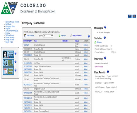
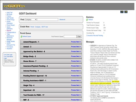
The following representative screen shots in Figure 8 and Figure 9 show the Company Dashboard a customer accesses when logging into a PSDC OS/OW system, in this case Colorado and Georgia, and the agency dashboard an agency user accesses, respectively. Both screen shots include the functional links each type of user will be able to access when using the system.
Oxcart Permits Systems
Oxcart Permits Systems offers a web-based application that links local permitting agencies and trucking companies in need of permits.
To utilize the Oxcart application, carriers and local government permitting agencies need to establish a free account with Oxcart. For government permitting offices, the Oxcart application is tailored to meet local ordinances and threshold requirements. Oxcart is developing a GIS mapping system that will allow users to expand, collapse, and manipulate a map to identify routes and restrictions. Local government agencies will be able to drag and drop permanent and temporary route restrictions and the system will be updated to generate a notice to all open permit holders of changes in route restrictions.
For carriers, they will submit all local permit applications, including the requested route through the Oxcart Web-based application. Oxcart in turn processes and submits the permit application with the requested route and all other required permit information to the appropriate local permitting agencies. Once the application is completed, Oxcart submits the permit application to the local permitting agencies for review and approval. Once the permit is approved and Oxcart receives notice, Oxcart in turn provides the carrier with the permit. The carrier may download and print the permit or access the permit on a smartphone, tablet, or other electronic communications devices.
The Oxcart application currently provides a vehicle library function where carriers can add, delete, and clone an unlimited number of vehicles and combinations of vehicles. Oxcart will have a complete route library function with the development of their new GIS mapping system. Oxcart also allows carriers to store company information and payment data to speed the submission process. Payments are routed through Oxcart via credit card, which is the only form of payment that Oxcart currently authorizes.
Additional information on the Oxcart application is available at: https://www.oxcartpermits.com/
4. The information on the SUPERLOAD product is adapted from: https://www.bentley.com/en/products/brands/superload [Return to Note 4]
5. Information source for GotPermits: https://www.bentley.com/en/products/product-line/asset-performance/gotpermits [Return to Note 5]