United States-European Commission Urban Freight Twinning Initiative: Compendium of Project Summaries
| |||
| Research | United States |
The purpose of the project was to create a large-scale, numerical optimization model for the design of urban distribution networks for major consumer markets of our collaboration partner, B2W Digital of Brazil. The model addresses:
To depict urban complexities as accurately as possible, the model was designed to incorporate various sources of relevant (big) data such as: company order and delivery data; high-resolution GPS traces from the current delivery fleet (in photo below); publicly available data such as travel times and distances from Google Maps; and geo-referenced information on real-estate cost and crime incidents.
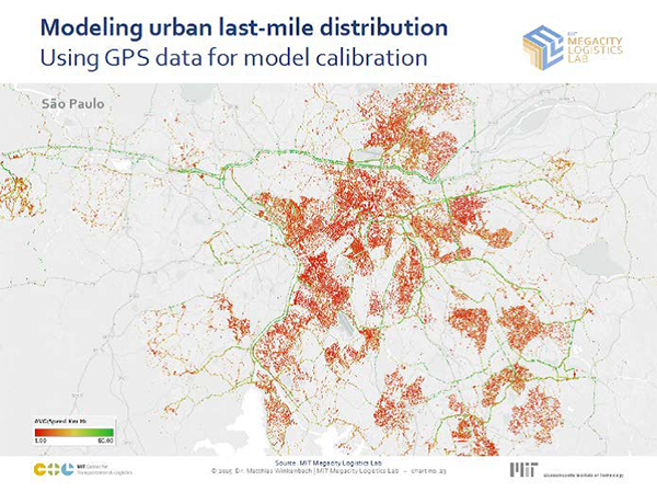
High-resolution GPS traces to inform model parameters for travel speeds, traffic patterns, stop locations, and durations.
Source: MIT Megacities Logistics Lab.
Research
February 2016 - January 2017
São Paulo, Brazil
Matthias Winkenbach
Director
MIT Megacity Logistics Lab
(857) 253-1639
MWinkenb@mit.edu
MIT produced a data-driven network design tool to be used by B2W Digital in its strategic design and operational planning of urban last-mile distribution to consumers in major Latin American cities. The tool allows B2W Digital to operate:
MIT developed novel methods of incorporating large amounts of high-resolution data from various sources into improved, large-scale, mathematical optimization models for the design and planning of distribution networks. In particular, MIT used the following data sources to better inform models of numerical network optimization and geometric probability methods for route length and cost estimation:
Private-sector research partner: B2W Digital, a major Brazilian e-commerce company.
|
United States Department of Transportation - Federal Highway Administration |
||