Findings on Connector Designation, Data to Support Planning, and Incorporation into State Freight Plans
Chapter 4. Conclusions on Data to Support Intermodal Connector Planning
Subtasks 9.2 and 9.3 examined a range of data-related items for freight intermodal planning. This section summarizes the results of these tasks.
Connector Data in Existing Databases
The primary sources of data to support intermodal connector planning are State Departments of Transportation (DOT) data collection programs, the Federal Highway Administration (FHWA), Highway Performance Monitoring System (HPMS), and the National Performance Measurement Research Data Set (NPMRDS). Other important databases include statewide crash databases, which are used to identify safety issues on connectors, while emerging geospatial data being developed at the Office of the Assistant Secretary for Research and Technology (OST-R) Bureau of Transportation Statistics (BTS) has the potential to provide linkages between connector activity and other elements of the transportation system. These four key databases are described in the following sections.
State DOT Data Collection Programs
State DOTs maintain databases that include information on designated National Highway System (NHS) freight intermodal connectors. These databases typically include vehicle classification count data, pavement condition, and roadway geometric information. Several States have also purchased Geographic Positioning System (GPS) data which allows for truck and auto speeds to be estimated. Additionally, State DOTs may have also conducted specialized studies, such as freight plans or corridor plans which incorporate traffic volume or other data on these roadways. Similarly, metropolitan planning organizations and other local transportation agencies may have conducted studies that include data on freight intermodal connectors.
Highway Performance Monitoring System
The HPMS provides data that reflects the extent, condition, performance, use, and operating characteristics of national roadways. It includes a limited amount of data on all public roads and more detailed data for a sample of arterial and collector roadways. These data are used to assess highway system performance and measure FHWA's and States' progress in meeting strategic goals. Data in the HPMS is updated on an annual basis. However, there is typically a two-year lag between the current year and the most recent HPMS release.
There are 69 different data items reported as part of the HPMS. To some extent, all of these data are useful in assessing the condition and performance of intermodal connectors. Under 23 U.S.C 315, States are required to submit certain basic data items that are important for analyzing any roadway, including intermodal connectors. These data are length, lane-miles, total daily traffic, truck daily traffic, and the International Roughness Index measure for pavements.
Other HPMS data items that are particularly useful for an assessment of intermodal connector roadways include items related to roadway inventory (Through Lanes, Right-Turn Lanes, Left-Turn Lanes, and Speed Limit); traffic (Capacity, Future Annual Average Daily Traffic (AADT); Number of Signalized Intersections, Number of Stop Sign Intersections, and Number of Other Intersections); and geometry (Lane Width, Median Type, Shoulder Type, and Left and Right Shoulder Width). All of these roadway characteristics have the potential to affect truck performance as observed through other data sources, such as NPMRDS.
National Performance Management Research Data Set
The NPMRDS contains passenger, truck, and combined travel time data on intermodal connector roadways. Although the goal is to fully cover all of the National Highway System (NHS), including intermodal connector roadways, this has not yet been achieved. Truck travel time data contained in the NPMRDS is derived from truck Global Positioning System (GPS) readings from various motor carriers nationwide. Because the carriers that participate are larger, the data can be skewed towards larger commercial vehicles (e.g., class eight and above).
Data in the NPMRDS is updated on a monthly basis. Typically, there is a two- to three-month lag between the current month and the latest month of data available in the NPMRDS. In addition to issues related to the coverage of the data, there are sometimes concerns about its accuracy, especially on routes of lower functional classification—where traffic volumes (and particularly truck volumes) are relatively low. Currently, there is no standardized methodology to filter out the effects of control delays or traffic incidents on the reported travel times. Because of that, average speeds derived from the travel times may appear to be lower than expected on some facilities based on local knowledge.
The primary future improvement to the NPMRDS that could aid in planning for intermodal connectors is to ensure their inclusion in the database. This may require broadening the universe of data sources. Because intermodal connectors are smaller roadways that most long-haul truck traffic would not utilize, a collection of smaller regional carriers may be needed to provide coverage on these roadways as they are more likely to use them on a daily basis. The other primary improvement to the NPMRDS regarding intermodal connectors should be controlling the quality of the data. This could be done by periodically examining derived speeds compared to the findings from local speed studies.
Crash Databases
At the Federal level, crash data on NHS intermodal connectors may be recorded through programs at the FHWA, Federal Motor Carrier Safety Administration (FMCSA), and the National Highway Traffic Safety Administration (NHTSA). As part of the Highway Safety Improvement Program under 23 U.S.C. 402, FHWA requires all States to complete Strategic Highway Safety Plans. At a minimum, these plans analyze fatalities and serious injury crashes, roadway, and traffic data. NHTSA requires that all medium and heavy trucks involved in a fatal accident report information on the crash as part of its Trucks in Fatal Accidents (TIFA) database—under Section 2009 of SAFETEA-LU (23 U.S.C. 402). Similarly, FMCSA requires motor carriers to report truck crashes that result in a serious injury or fatality under U.S. Code of Federal Regulations Parts 390.15.
None of the databases specifically denotes if a truck-involved crash occurs on an intermodal connector. This must be determined by a manual comparison of the crash location to the FHWA NHS Geographic Information System (GIS) files and information given online on the FHWA Office of Planning's Web site. Similarly, States are not required to specifically examine intermodal connectors as part of their Strategic Highway Safety Plans. Requesting that State Departments of Transportation (DOT) and other partner agencies indicate in crash data if a roadway is an NHS intermodal connector would greatly improve the ability to conduct safety analyses on intermodal connectors. An additional improvement to consider is States including intermodal connectors explicitly in Strategic Highway Safety Plans.
Bureau of Transportation Statistics GeoSpatial Tool
The BTS, in conjunction with the Office of Survey Programs and the Office of Spatial Analysis and Visualization, is developing an intermodal freight database schema to support the multimodal network analysis, routing, and mileage calculation associated with the development of the 2017 BTS Commodity Flow Survey (CFS). As part of this process, data elements were extracted from several databases across all freight modes, which will ultimately be linked with the freight flows estimated in the CFS. The database also will include geolocation data that will be used to map the locations of intermodal freight facilities, and demonstrate their connections with both the rest of the freight transportation network and the commodity flows estimated nationwide. Some of this database will be useful for assembling information on the intermodal connector database. For example, the intermodal pipeline portion of the database will have longitude and latitude information that will allow key pipeline terminals to be pinpointed geospatially. It also includes information on the types of goods that move through pipeline terminals and the type of handling that occurs at the terminals.
Facility Operator Databases
Some information on freight intermodal connectors may also be available from facility operators, such as marine ports, railroads, and airports. Some of these operators monitor the use, condition and performance of these roads as an ongoing part of a planning program, while others may have conducted studies which collected data on connectors as part of a specific planning effort. For cases where the designated connector is the primary roadway connecting the facility to the NHS, freight volume estimates at the facility can be used to generate estimates of truck volumes.
Linking Information in Existing Databases
The greatest obstacles to linking intermodal connector data across databases are: 1) the incompatibility of roadway network topology in GIS databases (e.g., HPMS, NPMRDS, and State crash databases and linear reference systems); 2) the lack of a consistent and unique link-level identifier for NHS routes; and 3) differing timeframes on which intermodal connector data is updated. In particular, the NHS has different physical representations across the FHWA and State GIS databases. Because of this, it is very difficult to conflate the two different networks and integrate information on intermodal connectors from major databases, such as the HPMS and NPMRDS, with any degree of accuracy.
In addition to having a consistent topology across GIS databases, consistent and unique link-level identifiers also would improve the ability to connect information on intermodal connectors across the various data sources. States create their own route identifiers according to schemes that vary across States. These are then entered into the HPMS database. The NPMRDS uses link-level identifiers (i.e., Traffic Management Codes or TMCs) that are unique to that source and do not match the link-level HPMS identifiers. In addition, roadway links in the NPMRDS vary in length while those in the HPMS are typically 0.1 mile in length. Thus, there is no way to link performance data derived from NPMRDS using the typical logical queries contained in database management systems, such as Access and Structured Query Language (SQL).
Linking condition, performance, and safety data in order to assess intermodal connectors also requires that the temporal differences among these data sources be considered. The HPMS is updated annually with an approximate two-year lag; the NPMRDS is updated monthly with a two- to three-month lag; the Fatality Analysis Reporting System (FARS) database is updated annually with a two-year lag; and State crash databases are typically updated annually with various lag times. Variation in the frequency of updates across databases present a challenge for making timely assessments of the condition and performance of intermodal connectors; by the time necessary data items are available, the operating environment has likely changed.
The inconsistencies in network topology, route identification, and the frequency of updates make it very difficult to draw on the full universe of data available to any analysis of NHS intermodal connectors. To resolve these issues, FHWA and its State partners would need to develop a GIS and cross-sectional database, such as a geodatabase, that represents the highway network in an accurate and useful manner for all stakeholders. This should be accompanied by new route identifiers that are consistent across all sources or provision of a crosswalk so that data can be matched across databases with minimal effort.
Conclusions on Utilizing Existing Databases to Support Freight Intermodal Planning
In 2008, the FHWA commissioned a survey and inventory of freight and other intermodal connectors. The survey information was used to build the Intermodal Connector Assessment Tool (ICAT), which provides a database describing the intermodal connectors and analysis routines to assess and summarize the use, condition, and performance of the connectors. The ICAT has been updated periodically as funding is available. The ICAT database has 21 data fields covering identification, ownership, use, condition, and performance. These fields define the baseline of data needed for effective intermodal freight planning and programming. As part of Subtask 9.3, the consulting team examined the potential development of this database as a stand-alone intermodal connector tool relative to the continued use of existing databases.
A stand-alone intermodal connector database would allow FHWA greater control over the accuracy of the data. This is because the quality of the individual data items could be vetted specifically for freight intermodal connectors. The quality of data drawn from existing databases reflects the priorities and focus on those databases, which are not designed with a focus on freight intermodal connectors. For instance, although the HPMS contains a good deal of data that is relevant to the condition and performance of intermodal connectors, the HPMS was designed originally to address national-level highway program performance. The HPMS covers the entire NHS and intermodal connectors are a relatively small component of the NHS in terms of miles. The HPMS, data collection, and quality control procedures focus on larger geographies and higher-volume roadways than ICAT. However, utilizing the existing HPMS data has the advantage of linking the intermodal connector database to an established ongoing program that is mandated to be collected by State DOTs on a regular basis. It might be more effective to attempt to improve the accuracy in this preexisting database rather than developing a separate database whose accuracy is maintained separately.
Much of the information of interest for intermodal connectors is available in a handful of public databases; most notably, the HPMS, the NPMRDS, and the National Bridge Inventory. However, crash data and more detailed roadway information, such as posted speed limits, must be obtained from multiple databases maintained by State DOTs. Although these data are still publicly available, their overall accessibility is hindered by the number of individual entities that must be engaged to obtain the data. Thus, although much of the intermodal connector data is publicly available, a stand-alone intermodal connector database would improve accessibility by gathering all that information into a single location. Accessibility of data would likely be much more challenging for a system that relied on existing databases. This is because there would be the need to connect to multiple databases whenever a full set of intermodal connector data was needed. However, this could be streamlined by developing preexisting processes and compatibility tables that allowed all of the data to be pulled in to a similar format each time it was extracted from the existing databases.
Updating information on intermodal connectors would be easier in a single database. A single database presents the opportunity to update every data item at the same time, which could improve the completeness of the data. In the 2009 report, Intermodal Connector Assessment Tool (ICAT) Focus State—Summary of Findings, participating States noted that the data required to support ICAT was often missing or incomplete. With a stand-alone database for intermodal connectors, FHWA could ensure that all the required data is present. Utilizing multiple databases is a challenge because each database has its own predetermined update frequency, which is unlikely to match that of the other databases on which the intermodal connectors rely. For instance, the NPMRDS is updated monthly while many other Federal databases (e.g., National Bridge Inventory, HPMS, etc.) are updated annually. There also is typically a one- to two-year lag between the time data are collected and time the data are available in the databases. Also, within the databases, not every data element will have an updated value; there will be holdovers from previous releases, so there is often a mismatch of data elements.
Maintenance requirements would be much more straightforward when utilizing a freight connector data that relied on existing databases. This is because the existing databases already are on their own maintenance cycles. The HPMS is maintained by the Office of Highway Policy Information; the NHS (including intermodal connectors) is maintained by the Office of Planning, Environment, and Realty; the National Bridge Inventory is maintained by the Office of Bridges and Structures; the NPMRDS is maintained through the Office of Operations; and the Freight Analysis Framework is maintained through a partnership between the FHWA Office of Operations, OST-R, and BTS). Maintenance requirements for a stand-alone database would be very resource-intensive, likely requiring staff that would be fully devoted to maintaining this database similar to how other databases currently are maintained at FHWA.
The choice between using a stand-alone database versus using an existing database depends on several institutional issues within FHWA. Developing a stand-alone freight intermodal connector database would improve several elements of planning related to freight connectors. However, the additional effort required to develop and maintain this database appears to exceed the current demand. Over the short and medium term, the consultant team recommends that FHWA consider leveraging and better utilizing freight intermodal connector data included in existing databases as the most cost and time effective way of improving the data available to Federal, State DOT, Metropolitan Planning Organization (MPO), and local agencies for planning and programming improvements to freight intermodal connectors. The focus of freight connector data improvement efforts should be on data quality within these existing databases. Most notably improving the accuracy of truck volume estimates on designated freight intermodal connectors was identified as an issue by many stakeholders and an analytical constraint in Phase I of this study.
Options for Improving Quality and the Amount of Data Available for Planning on Intermodal Connectors
The FHWA may wish to consider the following findings to improve the quality and amount of data available for planning on intermodal connectors. These are external findings and do not necessarily represent the current views of U.S. DOT, including FHWA. The findings center on increasing the frequency of existing data collection initiatives that support the HPMS and, in some cases, utilizing data from sources not currently utilized in the HPMS. These include terminal gate surveys and truck GPS data.
Truck Count Data. To improve truck count data on intermodal connectors, FHWA could require State DOTs to conduct classification counts on intermodal connectors every three to five years. This would ensure that the auto and truck volume data on intermodal connectors contained in the HPMS is just as accurate as on higher-volume roadways that typically receive more attention. While this would require a greater investment of time and resources by States, it would provide the most accurate estimate of trucking and related economic activity on freight-serving connectors.
Speed Data. Speed data on intermodal connectors may be derived from truck travel time data in the NPMRDS. However, the coverage of intermodal connectors in the NPMRDS is not yet fully comprehensive. FHWA should identify ways to work with the producers of NPMRDS data to rapidly increase coverage to fully cover all designated NHS freight intermodal connectors as these roadways are often not covered in speed databases that are procured by State DOTs. Once this occurs, FHWA should perform link-level matching between the intermodal connectors as represented in the HPMS and NPMRDS geodatabases. In that manner, speed data can be drawn into HPMS from the NPMRDS and used to calculate common performance measures, such as volume/capacity ratios and level-of-service ratings.
Crash Data. It is recommended that crash data on intermodal connectors be recorded as part of the HPMS data collection process. Crash data is routinely collected and geocoded by States as part of Strategic Highway Safety Plans and public health initiatives. Thus, the data are readily available and the number of crashes on each intermodal connector roadway link in the HPMS geodatabase could be easily understood and monitored. The supplied data should also indicate the number of crashes resulting in serious injuries and the number of truck-involved crashes.
Origin-Destination Data. Origin-destination data currently is not collected for freight intermodal terminals as part of any formal FHWA data collection program. The collection of truck origin-destination data would improve both FHWA's and its State DOT partners' knowledge of trucking activity. It would yield insight into the actual routes utilized by trucks to access freight terminals and the areas which generate and/or attract the greatest amounts of truck trips to and from freight terminals. For these reasons, origin-destination should be included in a revised data collection program. Periodic gate surveys conducted by State DOTs and/or MPOs at freight-serving terminals are recommended as the most comprehensive method to capture origin-destination information. The coordination with terminal operators required to conduct effective gate surveys also creates an opportunity to collect information on the supply chains served by the terminal and roadway. Alternatively, analysis of truck probe data can be used to gather origin-destination information. This would need to be accomplished using a probe data set that tracked individual vehicles separately, as opposed to a data set like NPMRDS which has data separated by highway segment links. Truck probe data is a non-intrusive means of collecting origin-destination data that does not require explicit permission from vehicle operators. Gate surveys typically require various levels of permission and are challenging to conduct on a regular basis due to resource requirements. However, gate surveys allow for collected origin-destination data to be matched with commodity, supply chain, and vehicle attribute data. It is also typically easier to ensure collection of a representative sample using gate surveys, because many truck probe data sets are over-representative of specific populations of trucks (e.g. long distance trucks).
Supply Chain Data. An alternative to collecting truck origin-destination data is to map the predominant supply chain paths served by the terminal and its connectors. Mapping the predominant supply chain paths would first require the determination of an appropriate geographic scale. Supply chains often have global as well as national nodes. In addition, for each terminal the largest volume freight flows by product or commodity group must be determined in order to identify the appropriate supply chain to map. Once those are done, identifying the supply chain paths could be accomplished through interviews with terminal operators, motor carriers transporting the relevant goods and products, and the shippers and/or brokers that initiated the shipments. The interviews would determine typical shipment origins, interim stops at warehouses and/or distribution facilities, and the last-mile connectors used to access the terminal. Quantitative data on supply chains can also be ascertained through the acquisition of freight transaction data in which typically the full end-to-end modes, locations, and transit speeds are specified. Using a combined quantitative-qualitative approach could yield very useful information that would allow for the development of informed supply chain paths without the computational burden of origin-destination data. Supply chain interviews also would collect information on seasonal variations in freight movement and business trends that have a marked effect on the number of trucks using an intermodal connector. This data would be particularly useful in designing data collection programs, ensuring efficient data collection targeted at time and locations that accurately reflect the use of the intermodal connector.
Pavement Condition Data. Pavement condition data for intermodal connectors can be obtained either directly from State DOTs or the HPMS database as pavement conditions are a required data item. As the HPMS contains information for all NHS routes, it is most efficient to obtain pavement condition data from the HPMS as all intermodal connectors are a part of the NHS. However, there are sometimes gaps and other inconsistencies in what is represented as the NHS in the HPMS database and what is presented in GIS files maintained by the FHWA Office of Planning, Environment, and Realty because of lags in State DOT reporting to FHWA, the construction or rerouting of roads, etc.
Despite these gaps, pavement condition data represented in the HPMS is comprehensive as information is provided for all NHS roadways, including intermodal connectors. However, because of the frequency of data collection and reporting, the pavement condition information in the HPMS may not be the most accurate. As States frequently repave, and even rebuild roadways, as traffic and environmental conditions cause deterioration, and pavement quality can vary considerably between HPMS updates. Additionally, it should be considered that many pavement condition measuring techniques are not as accurate on roadways with slower speeds and frequent stops, which is the case with many freight connectors.
Freight Performance Measures. There are a number of measures that can be used to track the performance of freight intermodal connectors. The National Cooperative Freight Research program (NCFRP) Report 10 describes freight performance measures across all freight modes for both the public and private sector. This can be used as a reference to consider in developing freight performance measures.
The FHWA final rulemaking on national performance measures includes freight movement on the interstate system through the measurement of truck reliability. Truck travel time reliability on the Interstate highway system is captured by calculating the Truck Travel Time Reliability (TTTR) index. The TTTR index is the metric used to express the freight performance measure specified in the Final Rule—Freight Reliability. (National Performance Management Measures: Assessing Performance of the National Highway System, Freight Movement on the Interstate System, and Congestion Mitigation and Air Quality Improvement Program, Federal Register, Vol. 82, No. 11, January 18, 2017.) The TTTR index is calculated as the ratio of the 95th percentile travel time to the 50th percentile travel time: TTTR = 95th Percentile Truck Travel Time / 50th Percentile Truck Travel Time. High TTTR values indicate unreliable truck travel times while low TTTR values indicate more reliable travel times. For example, a TTTR value equal to 2 indicates that truck travel times may be twice as long as average travel times for a given time period.
In effect, the TTTR index gives an idea of how variable travel times are on the highway network. Highly variable, or inconsistent, truck travel times result in unreliable service over the highway network. Unreliability is a direct cost to motor carriers as they must hedge against unreliable travel times by budgeting additional time into their schedules. This translates into higher transportation costs that may be passed on to shippers. More importantly, wasted time reduces available hours of service for the truck drivers.
The Freight Reliability measure is a weighted average (by segment length) of the maximum TTTR indexes observed over the five time periods specified in the Final Rule on performance measures. ((1) AM Peak = 6 a.m. – 10 a.m. Monday – Friday; (2) Mid Day = 10 a.m. – 4 p.m. Monday – Friday; (3) PM Peak = 4 p.m. – 8 p.m. Monday – Friday; (4) Overnight = 8 p.m. – 6 a.m. Sunday – Saturday; and (5) Weekend = 6 a.m. – 8 p.m. Saturday – Sunday.) Its calculation is required for the Interstate system only and is computed as follows:
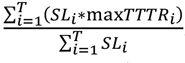
(National Performance Management Measures: Assessing Performance of the National Highway System, Freight Movement on the Interstate System, and Congestion Mitigation and Air Quality Improvement Program, Federal Register, Vol. 82, No. 11, January 18, 2017.) Where:
- i = An Interstate system reporting segment;
- maxTTTRi = The maximum TTTR of the five time periods of Interstate system reporting segment "i";
- SLt= Segment length of Interstate system reporting segment "i"; and
- T = A total number of Interstate system reporting segments.
It is recommended that the measures tracked in the Freight Reliability measure be extended to cover designated FHWA freight intermodal connectors.
Summary of Potential Next Steps
There are several next steps for FHWA to consider as a result of this study. The conclusions and findings described in this report were developed externally and do not represent the views of FHWA. There is the potential for FHWA to add some of this information into formal policy and guidance documents. This can occur within the context of current requirements to develop State freight plans (as described earlier in this chapter) or as part of the requirements incorporated into the designated NHS freight intermodal connectors program. Additionally, FHWA can reexamine the data requirements of national datasets such as the HPMS, NPMRDS, and truck crash databases to incorporate recommendations that will better describe their attributes as they relate to freight intermodal connectors (as described in Chapter 3).