Hillsborough Metropolitan Planning Organization Pilot of the Data Business Plan for State and Local Departments of Transportation: Data Business Plan
Chapter 3. Data and Gap Assessment
This section presents an inventory of current mobility data collection efforts by regional stakeholders and the results of a data and gap assessment to identify issues related to the collection, management, governance, and use of mobility data within the Hillsborough area.
Data Inventory
One of the metropolitan planning organization's goals is to increase its knowledge of partner agencies' current and future data sources available to support performance based planning. This section details several mobility data initiatives in the region while providing a comprehensive mobility data inventory for regional stakeholders. The information in this section was compiled based on the results of the stakeholder survey and follow-up phone interviews.
Bluetooth Probe Data—Florida Department of Transportation District 7, City of Tampa, Pinellas County, Pasco County
Bluetooth probe data collection is becoming widely utilized in the region. FDOT District 7 piloted TrafficCast's BlueTOAD system in partnership with the City of Tampa. The project is overseen by a one-vendor system (TrafficCast's BlueTOAD system) in order to maintain uniformity. The Bluetooth units are located on arterials since data collection is usually more difficult on those roadways as compared to freeways (where radar and toll-tag readers are used to capture speed data).
District 7 has installed numerous Bluetooth devices along arterial roads in Pinellas and Hillsborough Counties, as shown in figure 1. The units in blue are operated by District 7 and encompass Hillsborough, the City of Tampa, and Pasco counties. The original corridors were deployed in 2011. There is minimal coverage (only a few units) in Pasco County because District 7 decided to focus initially on the most congested corridors. However, District 7 is expanding the system and installing an additional 100 Bluetooth units throughout the district, including at least 15 units along SR 54 and SR 56 in Pasco County. This will provide coverage for the entire 3-county region. District 7 and the City of Tampa also installed readers around MacDill Air Force Base as part of a year long study to monitor traffic patterns between Gandy Blvd. and the four entrance gates to the base. District 7 monitors travel times on a daily basis and generates quarterly reports. The City of Tampa receives an email-based report on corridor conditions. The data from the District 7/City of Tampa Pilot Project is being archived, and District 7 traffic is responsible for archiving the data.
The units in red are operated by Pinellas County. Travel time data from these units support travel time message signs, traffic signal timing, and adaptive signal control. The original corridors were deployed in 2012. Pinellas County is expanding their system, with a 3-to 5-year additional commitment. Pinellas County hosts the BlueTOAD System and data on their own stand-alone server, and the data is co-hosted in their TrafficCast account as well.
Data is available to other agencies at the permission of District 7 and Pinellas County leadership, as there are no contractual commitments that refrain them from sharing the Bluetooth data. These two agencies are already engaged in a mutual agreement to share their Bluetooth data with one another.
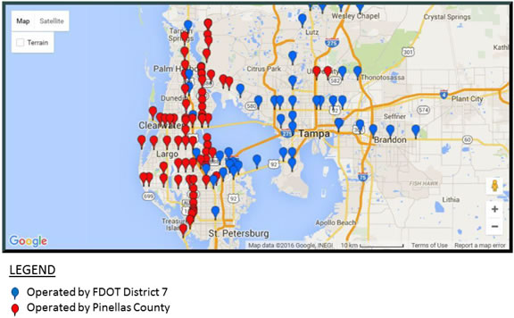
Figure 1. Map. Bluetooth deployment in the Tri-County Tampa Bay region.
(Source: Screenshot of Bluetooth locations—City of Tampa and FDOT D7.)
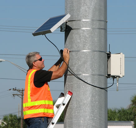
Figure 2. Photo. Instrumentation of Bluetooth device.
(Source: FDOT District 7.)
Waze—City of Tampa, Hillsborough County
The City of Tampa has been participating in the Waze Connected Citizens Program since January 2016. The program is designed to improve traffic conditions by facilitating a two-way data exchange between Google and U.S. government agencies that collect traffic data. The City of Tampa sends Google real-time and advance information on road closures, special events, and emergency evacuations for roadways within the city limits. Google uses the data to redirect drivers around roadway closures via the Waze navigation application. In the future, the City plans to send Google flood sensor information including flood warnings and related road closures. Waze plans to beta test a carpool application in Tampa next year.
In return, Google provides the City with real-time incident, slow-down, and travel time information as reported by drivers via the Waze application. The information is provided to the City as a real-time data stream and is not saved or archived. The City uses the data to monitor traffic conditions during peak periods. Google also provides traffic condition reports by corridor. Use of Waze data is subject to the terms and conditions in a standard licensing agreement.1 The agreement prohibits distributing or publishing aggregated or historic Waze data, except with Google's prior written consent. The agreement term is in effect until either party decides to end it.
Hillsborough County is also entering into an agreement with Waze. Hillsborough Metropolitan Planning Organization (MPO) also has a verbal agreement with Waze to obtain data, but the MPO cannot share the data with other agencies.
Florida Department of Transportation District 7 Mini-Reliable, Organized, Accurate Data Sharing
FDOT's District Seven office is conducting a Reliable, Organized, Accurate Data Sharing (ROADS) Project study based on the Central Office effort at the enterprise level.
Tampa Hillsborough Expressway Authority Autonomous Vehicle/Connected Vehicle Pilot Project
Tampa Hillsborough Expressway Authority (THEA) is currently engaged in an Autonomous Vehicle /Connected Vehicle pilot project which generating large dataset. THEA is very interested in linking this dataset with other available datasets to generate new insights and exploring the possibility of investing in data analytics software.
Mobility Data Inventory
Table 3 provides a comprehensive mobility data inventory for regional stakeholders. It includes the following information:
- Organization—the name of the organization responsible for collecting or managing mobility data.
- Mobility Data Collected—the type of mobility data being collected within the organization.
- Data Source—whether the data is collected internally, obtained from another agency, purchased from vendors, or other data source.
- Data Collection Method—whether the data is collected via probe vehicles, Geographic Positioning System (GPS), Bluetooth, or other data collection method.
- Network Type—whether the data is collected on freeways, highways, or arterials.
- Geographic Boundary—the geographic boundary for data collection.
- Time Period—whether the data is collected on an ongoing, sample, or one-time basis.
- Real time versus Archived—whether the data is aggregated in real-time or archived.
- Purpose—whether the data is used to support mobility planning or operations activities.
Table 3. Mobility data inventory.
| Organization |
Mobility Data
Collected |
Data
Source |
Data Collection Method |
Network Type |
Geographic Boundary |
Time Period |
Real Time versus Archived |
Purpose |
| Tampa-Hillsborough Expressway Authority (THEA) |
As a toll road, THEA primarily collects transaction data. However, they do collect some mobility data such as traffic volume counts and speeds. It is collected using microwave. They are installing Bluetooth as part of an Intelligent Transportation System (ITS) project. |
Obtained from another agency—FDOT.
Other—If we need travel speed, we will do traffic engineering studies. |
Bluetooth (FUTURE) |
Highways |
Lee Roy Selmon Expressway, Meridian Avenue, and Brandon Parkway. |
Samples |
Real-time Archive |
Operations Planning |
| Hillsborough County |
Speed (FUTURE)
Travel times (FUTURE) |
Other—Google Traffic/Waze (FUTURE) |
Other—Crowdsourcing (FUTURE) |
Freeways (FUTURE)
Highways (FUTURE)
Arterials (FUTURE) |
Within Hillsborough County (FUTURE) |
Ongoing (FUTURE) |
Real-time (FUTURE) |
Operations (FUTURE) |
| City of Tampa |
Volume
Speed
Travel times |
Obtained from another agency—FDOT
Other—Google Traffic/Waze
Collected internally using machine counters and laser/radar devices. |
GPS
Bluetooth/ BlueTOAD
Other—Crowdsourcing
Other—machine counter and laser radar devices |
Freeways
Highways
Arterials |
Within the City of Tampa and adjacent surrounding areas. |
Ongoing
Samples |
Real-time
Archive |
Operations Planning |
| Florida DOT District 7 |
Annual traffic count program
Special counts for design and corridor studies, etc.
Travel time, speed studies.
Transit routes/ridership for model base years.
OD Bluetooth data for special studies. |
Collected internally—consultant contracts/tasks.
Collected internally—traffic counts/speed data.
Purchased from vendors—Central Office INRIX purchase. |
Bluetooth/ BlueTOAD
Other—counters collect speed data. |
Freeways
Highways
Arterials |
Throughout District 7 and Statewide. |
Ongoing
Samples
One-time |
Real-time
Archive |
Operations
Planning
Other—Design
Other—PD&Es |
| Hillsborough Area Regional Transit Authority (HART) |
Speed
Distance
Fuel usage
Route and stop ridership
Wheelchair usage
Transit signal priority requests
Transit fare collection
Modes: fixed route, paratransit, and streetcar |
Collected internally. |
GPS |
Freeways
Highways
Arterials |
HART routes within Hillsborough County. |
Ongoing |
Real-time |
Operations
Planning |
| Center for Urban Transportation Research (CUTR) |
O-D and travel time data for bike, ped, transit, and vehicular. |
Collected internally, through their apps. |
Cellphone applications |
Freeways
Highways
Arterials |
City of Tampa, focused around the University of South Florida campus. |
Ongoing |
Real-time
Archive |
Other—app development |
| Hillsborough MPO |
Data to support multimodal level of service (LOS) reporting for highway/bike/ped/transit. Includes volumes, pavement conditions (lane configuration, widths, etc.), types of bike/ped facilities.
The MPO wants to incorporate travel time and speed data into its Multimodal Transportation Database. (FUTURE). |
Multimodal LOS data collected internally.
Travel time and speed data obtained from other agencies/vendors (FUTURE). |
FDOT will be collecting data to support system performance measures (FUTURE). |
Freeways
Highways |
Hillsborough County |
Ongoing
Other: FDOT will provide a snapshot annually (FUTURE). |
Archive |
Planning |
| Pinellas MPO |
Some sample data on all defined types of mobility data except connected vehicles. |
Obtained from another agency—Albeck Gerken, Inc. |
Bluetooth |
Arterials |
US19 Highway, which is the north/south spine of our county. |
Ongoing |
Real-time
Archive |
Operations
Planning |
| Pinellas County |
Bluetooth Travel Time Data (vehicle)
Computerized Signal System Sensor data (vehicle). |
Collected internally—Bluetooth and loop sensors. |
Bluetooth/ BlueTOAD |
Arterials |
County wide within Pinellas County. |
Ongoing |
Archive |
Operations
Planning |
| Pasco MPO |
Traffic volume |
Collected internally—Pasco Traffic Operations. |
Other—tube counts |
Freeways
Highways
Arterials |
Within Pasco County. |
Ongoing |
Archive |
Operations
Planning |
| Pasco County |
FDOT District 7 has plans to expand and install 15 additional Bluetooth units in Pasco County as part of the BlueTOAD project (FUTURE). |
Collected internally—Bluetooth (FUTURE). |
Bluetooth/BlueTOAD (FUTURE) |
Arterials (FUTURE) |
Within Pasco County (FUTURE). |
Ongoing (FUTURE) |
TBD |
TBD |
| Florida DOT Central Office |
Florida DOT has data on all defined types of mobility data to support development of the Florida DOT Multimodal Mobility Performance Measures Sourcebook. A matrix of measures is provided in appendix D. |
Varies |
Varies |
Varies |
Varies |
Varies |
Varies |
Operations
Planning |
| Department of Health—Hillsborough |
Socioeconomic, health, and walkability data that support transportation planning analyses. |
Unknown |
Unknown |
Unknown |
Unknown |
Unknown |
Unknown |
Unknown |
| Florida's Turnpike |
Volume
Speed
System reliability
Freight |
Collected internally—traffic count, toll data, origin and destination studies, preference surveys
Obtained from another agency—FDOT District Offices, comparisons with other States (e.g., Georgia)
Purchased from vendors—additional freight information is purchased through FDOT Central Office. |
Bluetooth |
Highways |
Statewide |
Ongoing
Samples
One-time |
Real-time
Archive |
Operations
Planning |
| City of Temple Terrace |
None |
N/A |
N/A |
N/A |
N/A |
N/A |
N/A |
N/A |
| City of Plant City |
System counts for ATMS Traffic System.
Local speed, volume counts for safety and development. |
Collected internally using road counters and system loops. |
Other—Loops and road tubes. |
N/A |
Within the City of Plant City limits |
Ongoing
Samples
One-time |
Real-time
Archive |
Operations
Planning
Other - Safety |
| Environmental Protection Commission |
Pollutant level data |
Unknown |
Unknown |
Unknown |
Unknown |
Unknown |
Unknown |
Unknown |
| Pinellas Suncoast Transit Authority (PSTA) |
Automatic passenger count data tracks ridership and related data.
Bicycle rack usage.
Real-time data tracks transit speed and on-time performance. |
Collected internally—Clever Devices Real Time Systems. |
GPS |
N/A |
Within Pinellas County, anywhere the PSTA buses run.
Limited parts of Hillsborough County, where PSTA bus routes run. |
Ongoing
Samples |
Archive |
Operations
Planning |
| Port Tampa Bay |
Unknown |
Unknown |
Unknown |
Unknown |
Unknown |
Unknown |
Unknown |
Unknown |
Data Assessment
The stakeholder outreach process was used to identify stakeholder needs related to the collection, management, governance, and use of regional mobility data programs, stakeholder coordination, and current capability/maturity. Table 4 summarizes stakeholder needs within each of these assessment areas. The results of the assessment will help prioritize data systems for enhancements or replacements to support mobility planning, operations, and performance measure activities.
4. Stakeholder needs and challenges.
| Area of Improvement |
Sub Area |
Stakeholder Need |
Source |
| Data Systems |
Data Gaps |
- The MPO needs data to support calculation of Florida DOT performance measures, such as travel time reliability and return on investment for projects.
|
Phone calls |
- The MPO wants to incorporate national datasets into its Multimodal Transportation Database, such as the National Performance Management Research Data Set (NPMRDS) / HERE (formerly Navteq) data, as well as connected vehicle data to enhance transportation analysis for the region.
|
Phone calls |
- Need additional travel data, mainly turning movement counts at intersections on a continuous basis.
|
Survey |
- Need to obtain travel time data on more facilities. Specifically SR 60, which was discontinued. It is a main beach access arterial.
|
Survey |
- More origin and destination data would be useful for planning purposes.
|
Survey |
- Pedestrian and bicycle activity data is the most needed.
|
Survey |
| Data Collection |
- Need to make better use of expanding data sources for performance management.
|
Survey |
| Data Standards |
- There is a need to assess how data could come from connected vehicles through a Data Business Plan (DBP) environment to support planning in general.
|
Survey |
- Intensive work to set out machine counters, not to mention exposure to traffic, which can be unsafe.
|
Workshop |
- There is always room for improvement in data quality/data collection standards for travel time/ speed.
|
Workshop |
| Business Processes |
- If Bluetooth or GPS probe data isn't based on a good sample size, results can be skewed.
|
Survey |
- Knowing whether data collected is continuous or a one-time collection is very important.
|
Survey |
- Travel time and speed data is obtained based on site-specific needs through our GEC. There are no systematic ways for data gathering.
|
Survey |
- Managing and analyzing this data is time intensive. We are currently doing it with the same staffing level as before.
|
Phone calls |
| Business Processes/Data Integration |
- Ideally, the MPO would like to attach travel time data to roadway segments in Multimodal Transportation Database. They would like the ability to conduct analysis such as determining the average travel time and standard deviation during the PM peak on a typical weekday, or determining whether there is a correlation between travel time on arterials and fatality rates.
|
Phone calls |
| Data Integration |
- Currently, data is not integrated across the region, which limits the MPO's ability to conduct analysis to support performance based planning.
|
Phone calls |
| Data Integration/Data Sharing |
- The MPO is interested in integrating other datasets (planning for operations, connected vehicle data) into its Multimodal Transportation Database. However, data integration is a challenge and will require improving the structure of the database.
|
Phone calls |
- It is an interagency mission to incorporate travel time and speed data into the MPO databases and make it available to planning partners.
|
Phone calls |
| Data Sharing |
- Private vendors are willing to install a device in signal cabinets to gather roadway performance measures. These measures are available to the municipality, but the company may also sell that information to Original Equipment Manufacturers.
|
Survey |
- Data availability is not publicly advertised, so access is limited.
|
Survey |
- Data sharing obstacles include proprietary restrictions and data sharing platform.
|
Survey |
| Data Storage and Access |
- Access to data is a major issue. If GPS data contains personally identifiable information (PII), agency access is limited unless they obtain a special type of research certification.
|
Workshop |
- Limited access to test data was cited as an obstacle.
|
Workshop |
- Data size is an obstacle.
|
Workshop |
| Technology & Tools |
Software/Tools |
- Technical challenges exist with specialized software needed to access GPS probe data.
|
Workshop |
- Although the NPMRDS/HERE data seems to be a good source of travel time data, manipulating the data using traditional database software (e.g., Microsoft Access) is difficult due to file size limitations (e.g., 2 GB).
|
Phone calls |
- Data from private vendors such as NPMRDS/HERE are difficult to manipulate due to the large file size and network conflation challenges.
|
Phone calls |
- The MPO would like to make more use of NPMRDS datasets, but it requires specialized software tools such as Statistical Analysis Software (SAS). The MPO has not evaluated this capability.
|
Phone calls |
- Travel time data in the NPMRDS is associated with the National Highway System, which represents only a portion of the MPO roadway network. The MPO is able to download other files to generate reports in MS Access based on location. The MPO can do light reporting using the travel time data and static table with Traffic Message Channel (TMC) location codes. However, it is challenging to do spatial joins in GIS due to file size.
|
Phone calls |
- The MPO has a need for more robust tools to handle large datasets.
|
Phone calls |
| Network Testing |
- Network testing was cited as an obstacle.
|
Workshop |
| Data Governance |
Data Ownership |
- Not knowing the owners of data was cited as an obstacle.
|
Workshop |
| Collaboration |
- 45% of survey respondents indicated they do not currently share travel time/speed data with other organizations, but they are willing to do so.
|
Survey |
- The MPO wants to collaborate with regional partner agencies to identify additional sources of mobility data for the database, but they do not know what types of data are available.
|
Phone calls |
- There is no systematic process or platform in-place for sharing data with partner agencies.
|
Phone calls |
- Collaboration takes place between individual partner agencies and FDOT, but should be expanded to other regional partners.
|
Survey |
Assessment of Capability
An assessment of the Hillsborough region's capabilities for collecting, managing, governing, and using mobility data was conducted using a capability maturity model. The maturity model assists agencies in assessing their current capabilities with respect to data management and governance and identify the next steps in achieving the goals and objectives of the DBP. The maturity model defines levels of maturity for each of the following assessment areas:
- Data Collection, Management, and Technical Standards: What mobility data are collected? Are the data sufficient to support mobility planning, operations, and performance measure activities? Are there overlaps or redundancies in data collection or management efforts? Are business processes for data collection, updating, quality assurance, data processing, and use documented? Is there an inventory of available mobility data systems (in a data registry)? Are adequate data collection standards and metadata in-place?
- Data Integration and Expandability: To what extent are mobility data sets linked to support performance measurement and asset management purposes? Are existing mobility data systems expandable as new technologies and tools are developed?
- Data Storage and Access: Are data easily accessible? Are users able to find the data they need and in the format they need it in?
- Technology and Tools: Do users have access to the business analysis tools they need to support mobility planning, operations, and performance measure activities? Are technology and tools to support data management and analysis consistent, standardized, and updated?
- Data Governance: Is there a governance structure for mobility data programs in-place? For example, are roles, responsibilities, and processes for managing data formalized and documented? Is there a designated data governance board, data stewards, and data owners?
- Culture: Does top management visibly support data management/governance efforts? (i.e., provides resources, supports initiatives by signing charters, etc.) Are adequate resources committed? Is mobility data promoted as an agency-wide asset? How is the program made visible and relevant to management and staff?
- Collaboration: Are internal and external partner agencies appropriately aligned and working together productively? Do stakeholders collaborate on topics relevant to mobility data (e.g., sharing RFP's for current and upcoming initiatives, procurement plans, and best practices related to specific types of mobility data)? Has collaboration been successful?
There are three distinct levels of capability for each assessment area:
- Level 1: Initial/Under Development. Activities and relationships are largely ad hoc, informal, and champion-driven, substantially outside the mainstream of other activities. Alternatively, the capability is under development, but there is limited internal accountability and uneven alignment with other organizational activities.
- Level 2: Defined/Managed. Technical and business processes are implemented and managed, partnerships are aligned, and training is taking place.
-
Level 3: Optimized. Data management and governance is a full, sustainable program priority, with continuous improvement, top-level management support, and formal partnerships in-place.
Figure 3 presents the draft results of the capability assessment. The hollow circle ( ) indicates current level of capability within the assessment area, which was determined based on the list of stakeholder needs. The solid circles indicate the target level of capability, and they are color coded to reflect the degree of gap. For example, the green circle ( ) indicates current level of capability within the assessment area, which was determined based on the list of stakeholder needs. The solid circles indicate the target level of capability, and they are color coded to reflect the degree of gap. For example, the green circle ( ) indicates no gap, in which the desired level of capability is the same as the current level. The yellow circle ( ) indicates no gap, in which the desired level of capability is the same as the current level. The yellow circle ( ) indicates a small gap (e.g., one level difference) between current and desired levels of capability. The red circle ( ) indicates a small gap (e.g., one level difference) between current and desired levels of capability. The red circle ( ) indicates a large gap (e.g., two levels) between current and desired levels of capability. ) indicates a large gap (e.g., two levels) between current and desired levels of capability.
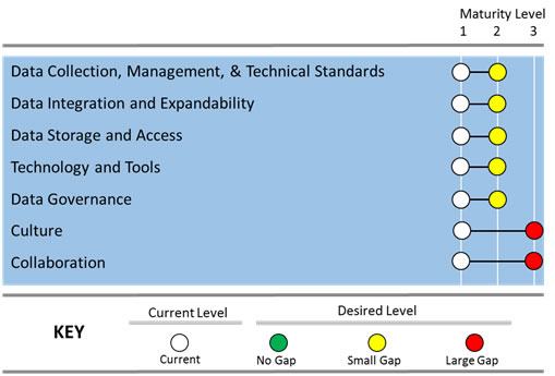
Figure 3. Graph. Assessment of capability.
(Source: Cambridge Systematics, Inc.)
Summary of Gaps
Table 5 summarizes the gaps and overlaps that exist in program activities related to data systems, technology and tools, and data governance, culture, and collaboration. These gaps need to be addressed to advance the region from current to desired levels of capability within the assessment areas.
Table 5. Summary of gaps.
| Dimension |
Gaps |
| Data Systems |
- Gaps in travel time/speed data, turning movement counts at intersections, origin/destination data, pedestrian/bicycle activity data, and data to support calculation of return on investment.
|
- Assess how connected vehicle data could be incorporated into the Multimodal Transportation Database and used for planning purposes.
|
- Improved data quality/data collection standards for travel time/speed data.
|
- Define data standards for Bluetooth/GPS probe data.
|
- Make better use of expanding data sources for performance management.
|
- Develop/formalize business processes for the following:
- Systematics process to gather travel time/speed data from partner agencies.
- Procedures for managing and analyzing mobility data.
- Procedures for attaching travel time data to roadway segments in the Multimodal Transportation Database.
- Procedures for analysis such as determining the average travel time and standard deviation during the PM peak on a typical weekday, or determining whether there is a correlation between travel time on arterials and fatality rates.
|
- Define a Method for data integration.
|
- Improve the structure of the Multimodal Transportation Database to support data integration.
|
- Develop data sharing platform to support external partner agency access to the Multimodal Transportation Database.
|
- Address proprietary and personally identifiable information (PII) data restrictions.
|
- Address data storage issues associated with data size.
|
| Technology and Tools |
- Use more robust analysis tools to handle large datasets.
|
- Perform staff training on use of analysis tools.
|
- Address network conflations issues associated with NPMRDS/HERE data.
|
- Address network testing issue.
|
| Data Governance, Culture, and Collaboration |
- Improved collaboration among partner agencies to increase awareness of mobility data availability.
|
- Have a formal governance or collaboration program.
|
- Define systematic process for sharing data with partner agencies.
|
Improvement Strategies
This section summarizes strategies for the Hillsborough MPO and its partner agencies to improve mobility data systems, data collection methods, data storage environments, data quality standards, data integration, data analysis, and analytical tools. Table 6 recommends improvement strategies to address each gap and assigns a priority for implementation as follows:
- High: Strategies/actions that should be implemented as soon as possible as they significantly improve the assessment dimension and gaps.
- Medium: As time and investments permit, these strategies/actions should be implemented.
- Low: The benefit provided by these strategies/actions do not significantly improve the assessment dimension and gaps. These strategies/actions can be implemented as time and investments permit, but are lowest in priority.
Table 6. Improvement strategies.
| Dimension |
Sub Area |
Strategies |
Priority |
| Data Systems |
- Data Collection/ Acquisition
|
- Incorporate traffic count data from other local agencies into the Multimodal Transportation Database. Initial efforts should focus on short-term count data from Hillsborough and Pinellas MPOs.
|
High |
- Address gaps in travel time/speed data, turning movement counts at intersections, origin/destination data, pedestrian/bicycle activity data, and data to support calculation of return on investment.
|
Medium |
- Address data gaps to meet requirements of the MAP-21/FAST Act Performance Management regulations.
|
High |
- Utilize NPMRDS travel time data and combine it with regional traffic volume data.
|
Medium |
- Archive travel time/volume data and make it available to support MAP-21 requirements.
|
High |
- Develop specifications for collecting, updating, maintaining, and archiving mobility data in the Multimodal Transportation Database and assign responsibility for these activities.
|
High |
- Develop systematic process to gather/update travel time/speed data from partner agencies.
|
Medium |
- Identify opportunities for collaboration between connected vehicle data capture activities and existing data programs.
|
Low |
- Conduct annual review of regional mobility data programs to identify duplicate data collection and storage activities. Eliminate and replace with single source of data for specific data programs to ensure data is collected once and used many times.
|
High |
- Identify applications that use expanding data sources, such as Strava.
|
Low |
- Data Quality
|
- Develop policy to define responsibilities for data quality assurance, including accuracy, timeliness, completeness, validity, coverage, and accessibility.
|
Low |
- Adopt data quality standards for collection, processing, use, and reporting of mobility data.
|
Medium |
- Require metadata for mobility data systems.
|
Low |
- Document quality control procedures, including instructions on how to process data errors.
|
Medium |
- Develop validation rules and allowable values for coded fields and incorporate these rules into data systems and data repositories. Use established validation rules to the greatest extent possible.
|
Low |
- Data Standards
|
- Develop and enforce data quality standards for travel time/speed data. Ideally, enforcement should be a collaborative effort whereby participants agree on holding each other accountable.
|
High |
- Develop standard data template format to foster joint usage and collaboration on mobility data.
|
Medium |
- Develop minimum regional standards for Bluetooth/GPS probe data
|
Low |
- Ensure coordination with applicable national data standards.
|
High |
- Develop policy to define responsibilities for supplying metadata, data dictionaries, and descriptive information for mobility data systems to facilitate the understanding, characteristics, and usage of data.
|
Medium |
- Develop metadata guidelines to indicate data name, size, data type, where data is located, data ownership, update frequency, age of data, and how data can be used or integrated with other data sources.
|
Low |
- Data Integration and Expandability
|
- Leverage the Regional Integrated Transportation Information System (RITIS) as a tool for data integration. RITIS is available through FDOT District 7, so no procurement purchase is required. The MPO should facilitate the RITIS implementation effort from planning through fruition.
|
Medium |
- Use common linear network to facilitate data sharing and integration.
|
High |
- Develop procedures for attaching travel time data to roadway segments in the Multimodal Transportation Database.
|
High |
- Determine improvements needed to the structure of the Multimodal Transportation Database to support data integration.
|
High |
- Data Storage and Access
|
- Understand stakeholders' business needs for mobility data access and sharing.
|
Medium |
- Develop policy to define responsibilities for data storage, hosting, data retention/archival, and disposal.
|
Medium |
- Develop policy to define data ownership and dissemination rights.
|
Medium |
- Implement standard data sharing agreement with internal and external stakeholders.
|
High |
| Technology and Tools |
- Business Analysis Tools
|
- Explore use of tools to integrate data from other systems and to enhance data sharing among regional stakeholders. These could include use of XML formats for sharing data, GPS technology for collecting and geocoding data location, and GIS tools for geographical display of data.
|
Medium |
- Share published data in a centralized location such as the Multimodal Transportation Database, SharePoint, or open data portal that is accessible to internal and external stakeholders.
|
High |
- Involve network/database administrators from partner agencies in development of shared data portal.
|
High |
- Develop procedures for conducting analyses such as determining the average travel time and standard deviation during the PM peak on a typical weekday, or determining whether there is a correlation between travel time on arterials and fatality rates.
|
Medium |
- Develop and implement training program on use of analysis tools.
|
Medium |
| Data Governance, Culture, and Collaboration |
- Data Governance
|
- Implement a formal governance or collaboration framework.
|
High |
- Identify and assign governance roles and responsibilities.
|
Medium |
- Develop, maintain, and enforce a Data Governance Manual.
|
Medium |
- Develop and publish a Data Catalog to increase awareness of mobility data availability.
|
High |
- Develop and publish a Business Terms Glossary to define standard terminology for how mobility data is defined and used across the agency.
|
Medium |
- Hold a Data Summit or conference to engage regional stakeholders and share ideas.
|
Low |
- Identify resource needs.
|
Medium |
- Collaboration
|
- Identify datasets that can be openly shared.
|
High |
- Determine which stakeholders are willing to engage in a data sharing agreement.
|
High |
- Develop contract language for vendors to ensure data can be shared with other agencies.
|
Medium |
- Data Privacy and Security
|
- Establish and maintain security standards to secure data and protect privacy of individuals and contributing agencies.
|
High |
- Clearly document policies, standards, and procedures and distribute to all staff responsible for collecting, maintaining, or distributing mobility data.
|
Medium |
- With respect to accessing and using data with personal identifiable information (PII), stakeholders should be aware of the applicable privacy protections and are encouraged to seek further legal guidance with their attorneys.
|
Medium |
- Further explore Privacy by Design as a way to address privacy concerns.
|
Low |
- Performance Measures
|
- Define performance indicators and implement a monitoring program to measure the success of the governance program. Performance indicators should measure program activities (i.e., outputs) and confirm the governance program is delivering results (i.e., outcomes). Output indicators quantify the activities of the Mobility Data Task Force and reflect the level of effort expended or scale/scope of activities. Outcome indicators quantify the effectiveness of the Coordination Group in terms of meeting its mission and stated goals. Example output and outcome indicators are provided in the Example Data Governance Manual in appendix G. Document the adopted measures in the Data Governance Manual.
"Note this reference to performance measures is not related to performance management requirements that are being implemented as pursuant to several rules codified in 23CFR part 490. In no way does this substitute for compliance under that rule. See FHWA TPM website for details related to 23CFR part 490." |
Low |
- Establish a communication protocol and plan for communicating performance measure results to executive level staff, Mobility Data Task Force, and data users/stakeholders.
|
Medium |
- Risk Assessment
|
- Conduct risk assessment to identify regional mobility data programs and current and potential risks associated with these programs (e.g., what would happen if there was a loss of data or data quality issues). A risk assessment matrix can be used to determine: 1) how much data is needed; 2) how accurate data should be; 3) what the refresh rate of the data should be; 4) who should have access to the data; and 5) potential risks of data loss.
|
Low |
- Develop Risk Management Plan to address risks if they occur. Risk management practices should include disaster recovery procedures.
|
Low |
| Data Governance, Culture, and Collaboration |
- Knowledge Management
|
- Develop and implement a Knowledge Management system for organizing, storing, and archiving knowledge regarding mobility data sets and workflow processes. This ensures lessons learned and experiences pertaining to mobility data are retained and archived as staff retire or leave the organization.
|
High |
|