Freight Intermodal Connectors Study
Chapter 4. Case Studies
The objective of the Federal Highway Administration (FHWA) Intermodal Connectors Study is to provide a comprehensive understanding of the condition and performance of the Nation’s freight intermodal connectors. The case studies were conducted in conjunction with the Maritime Administration. Therefore, case study locations include more port case studies relative to the other freight modes.
Three emerging industries were included as case studies to focus on how connectors respond to changes in economic activity and supply chains. The emerging industries covered the emergence of oil and gas extraction in Williston in North Dakota; the truck-truck terminal facility in the City of Industry in southern California; and the potential for the use of natural gas as a transport fuel in Jacksonville, Florida.
The specific case studies are listed in Table 12.
Methodology
The case study methodology included three primary components:
- Assembling existing data on the use condition and performance of the corridors.
- Reviewing previous freight-related planning documents.
- Outreach to freight stakeholders.
The FHWA Highway Performance Monitoring System (HPMS) database and National Performance Management Research Data Set (NPMRDS) were reviewed for each case study connector. HPMS provided data on traffic volumes (truck and passenger), pavement conditions, and functional classification. NPMRDS provided data on truck travel times along some network links from which average truck speeds were derived.
At the State and local levels, information was gathered from long- and short-range planning documents. This included reviewing plans developed by State Departments of Transportation (DOTs), county or city county transportation departments, and metropolitan planning organizations, where applicable. The standard types of documents that were examined included long-range transportation plans (LRTP), congestion management plans (CMP), transportation improvement programs (TIP), and freight plans. Additional documents that were examined included corridor studies, sub-area studies, and freight facility studies. All of these documents were used to understand a connector’s current and future conditions (including level of service), planned improvements, and to provide information on how stakeholders convene to conduct freight-related planning.
Stakeholder outreach was used to confirm data sources identified by the consultant team, and determine if there are other data sources or reports that need to be reviewed. Outreach was also used to determine how freight planning related to the connectors was conducted. This included identifying freight champions, describing forums and venues that were used to gain consensus, identifying relevant neighborhood communities, and determining funding mechanisms that are available that can be directed towards freight intermodal connectors. The stakeholders contacted as part of this process were typically DOT and metropolitan planning organization (MPO) freight planners along with freight facility operators and economic development agencies, where appropriate.
Connector Characteristics
Across the 18 case study terminals, 61 roadways were incorporated into the case study process. Most of these roadways are officially designated National Highway System (NHS) freight intermodal connectors. Other roadways are used as connectors, but not officially designated as part of the NHS.
Of the 61 intermodal connectors examined in the case studies, approximately 70 percent are official NHS connectors. Most of the connectors are classified as either Principal or Minor Arterials. Several of them have multiple functional classifications across their extent. Often, these are combinations or Major Collector/Local Road and Minor Arterial/Major Collector. On average, the case study connectors have a somewhat higher functional classification relative to the total population of freight intermodal connectors as described in Chapter 3.
The vast majority of freight intermodal connectors studied have between two and four lanes. Sixteen of the 61 (26 percent) connectors consist of two lanes across their entire length. Another 15 of the connectors ranged from two to four lanes, while 12 of the connectors were comprised of four lanes. Only six of the connectors had six or more lanes. Twelve of the connectors had no information available on the number of lanes, primarily due to non-inclusion in the HPMS database.
Connector Truck Volumes
HPMS has good coverage of traffic volume data on the case study intermodal connectors. The database contains information on approximately 78 percent of the 61 case study connectors (Table 13). All of the designated NHS freight intermodal connectors included in the case studies are covered in the HPMS data base. The HPMS did not cover any of the non-designated connectors that were included in the HPMS database. Therefore, one of the benefits of a roadway being designated as a freight intermodal connector is that the roadway then becomes included in the HPMS database resulting in truck and auto volume data being collected on the roadway.
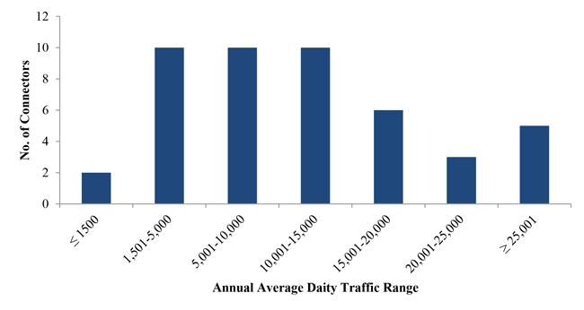
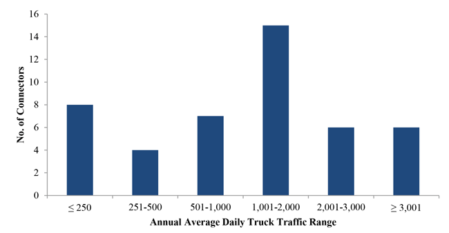
Figures 6 and 7 show the distribution of Annual Average Daily Traffic (AADT) and Average Annual Daily Truck Traffic (AADTT), respectively. The AADTT on the case study intermodal connectors is 1,590 trucks per day with a range from 12 to 3,050 trucks per day. The case study connector truck volumes data tended to have large volumes of single unit trucks relative to combination trucks and this common database error is explained in Chapter 3.
Table 13 also shows there is some differential between average truck volumes on case study connectors based on freight mode. Intermodal connectors serving airports have higher truck volumes than those serving any other freight facilities. This may be due to the dual impact of air cargo operations and trucks needed throughout the day to supply airplanes and airport concession operators. Port and rail intermodal connectors are next highest in terms of truck volumes.
The 14 non-NHS designated intermodal connectors examined in the case studies exhibited even higher AADTT values than the NHS designated connectors. The case studies demonstrated that these roadways often reflect the changing conditions of the freight terminals they serve. As rail traffic shifts to other rail yards, truck gates are expanded or new gates constructed at seaports, and capacity is increased at rail and marine intermodal container terminals, area truck traffic patterns also change. The non-NHS designated connectors are often indicative of these current conditions.
(Source: Federal Highway Administration Highway Performance Monitoring System database.)
Figure 6. Graph. Distribution of Intermodal Connector Annual Average Daily Traffic—2013
(Source: HPMS database, consultant analysis.)
Figure 7. Graph. Distribution of Intermodal Truck Annual Average Daily Traffic—2013
(Source: Federal Highway Administration Highway Performance Monitoring System database.)
Connector Pavement Condition
Pavement condition data are available on 47 of the 61 (75 percent) of the case study connectors. For the 47 designated NHS connectors, the HPMS pavement data are available on 40 (85 percent) of the connectors. For the 14 non-designated connectors, HPMS pavement data are available on only one of the connectors.
Table 14 shows that the average International Roughness Index (IRI) values of the case study intermodal connectors is 196 which rates as “mediocre”. One-third of the connectors rate as being in “poor” condition. Only five percent of the connectors are rated as “good” or “very good”. This distribution is similar to the pavement conditions for all connectors.
(Source: Federal Highway Administration (2013). Chapter 3—System Conditions, Status of the Nation’s Highways, Bridges, and Transit: Conditions and Performance Report.)
The pavement ratings of each of the case study connectors were compared to the pavement ratings of other roadways in their respective States within similar functional classifications. Table 15 shows that 78 percent of the case study intermodal connectors have higher IRI values (worse pavement conditions) relative to roadways in their States with similar functional classifications. This implies that the vast majority of the connectors are not as well maintained as similar roadways. This may be due to longer maintenance cycles applied to connectors. Alternatively, this may be the result of higher truck volumes on the connectors. This would cause excessive pavement damage which would require increased maintenance to achieve similar pavement quality as what is experienced on non-connector roads.
On average, the IRI rating for the case study connectors was 55 percent higher than similarly classed roadways in their respective States. The average IRI rating for similarly classed roads to the connectors in their States was 128. This indicates that the difference in pavement quality is significantly worse for connectors relative to similar roads. The rougher pavements of freight intermodal connectors likely contributes to higher vehicle maintenance costs and also to loss and damage of the goods being transported. Additionally, it is possible that the freight intermodal connectors received less attention from transportation agencies relative to other roadways.
In conducting the case studies, references to pavement issues were relatively rare. Only one stakeholder mentioned this being a significant driver of an improvement project. The Georgia Ports Authority (which owns and operates the Port of Savannah) informally identified the Chatham County pavement conditions on Grange Road as an impediment to cost-efficient freight mobility. This spurred a resurfacing project to improve conditions on Grange Road. The only formal pavement analysis of intermodal connectors identified in the case study research was conducted in the Chicago metropolitan area as part of the development of the region’s truck route network.
Table 16 shows the IRI pavement ratings for case study connectors by terminal mode. This table shows that freight rail intermodal connectors have the best pavement conditions with an average IRI rating of 107. This rating qualifies as “Fair,” but it is very close to being rated as “Good” pavement condition. Air cargo intermodal connectors have the second best pavement condition with an average IRI rating of 168. These modal connectors also are rated as “Fair,” but they are very close to being rated as “Mediocre.” The port intermodal connectors have the worst pavement conditions of all of the roadways with a rating of 230 which qualifies the condition as “Poor.”
(Source: Federal Highway Administration Highway Performance Monitoring System database.)
| Connector Freight Mode | Average International Roughness Index (IRI) Rating | IRI Category |
|---|---|---|
| Rail | 107 | Fair |
| Air Cargo | 168 | Fair |
| Port | 230 | Poor |
(Source: Federal Highway Administration Highway Performance Monitoring System database.)
Connector Truck Travel Speeds and Congestion
Truck travel speeds on the case study connectors were examined for the month of April 2014 between the periods of 8:00 to 9:00 a.m., 12:00 to 1:00 a.m., 5:00 to 6:00 a.m., and Midnight to 1:00 a.m. These time periods are directly comparable to those used for the analysis of all of the connectors described in chapter 3.
The availability of truck travel speed data on the case study connectors is provided in Table 17. Fifty-two percent of the connectors have data available for the travel speed analysis. Seventy-one percent of designated NHS case study connectors had truck travel speed available, while 24 percent of the non-designated case study connectors had truck travel speed available.
Table 18 shows the average truck speeds by time of day and mode for the case study connectors. The highest average speed is 31 mi/h on rail intermodal connectors during the nighttime period. The rail mode also experienced the most congested periods with a morning period that featured average speeds 35 percent below the nighttime period. Airport connectors had the lowest average nighttime speeds at 26 mi/h, but had daytime congestion that reduced speeds no more than 11 percent.
Port and rail intermodal connectors were found to have the most often congested corridors, with 75 percent of their corridors having daytime speeds that were less than 90 percent of free-flow speeds. Only 38 percent of the airport intermodal connectors were found to be congested during daytime hours. The lower congestion for airport intermodal connectors may be due to the dual role of these connectors as serving both passengers and goods movement, and therefore having more opportunities to be considered for transportation improvements. The higher number of non-freight trips on airport intermodal connectors also resulted in a lower percentage of the total congestion on these roads being absorbed by truck trips.
(Source: Federal Highway Administration National Performance Management Research Data Set.)
(Source: Federal Highway Administration National Performance Management Research Data Set.)
Governance and Stakeholder Coordination
There was no pattern in the ownership of intermodal connectors included in the case studies. In fact, it was not uncommon for a single connector to have multiple owners as many extend across county and municipal boundaries. Intermodal connectors serving the Port of Savannah are a good example of this observation. Portions of the intermodal connectors lie in the City of Savannah, City of Pooler, City of Port Wentworth, Garden City, and unincorporated Chatham County in Georgia. Maintenance of these roadways is divided between the Georgia Department of Transportation, Chatham County, and city governments. The presence of so many government entities makes stakeholder coordination and leadership from freight champions critical for successful planning related to intermodal connectors. This is especially true considering that formal freight planning processes are still evolving at most transportation agencies.
The impetus to plan for freight intermodal connectors generally arose from one of two sources: 1) State-level concerns about economic development; and 2) community/local concerns regarding high levels of truck and rail traffic near residential neighborhoods. This observation highlights an important challenge faced by intermodal connectors and the freight terminals they serve. They often facilitate economic activity that yields benefits across a wide geographic scale though the negative externalities are borne locally. Though this observation on the freight system has been made before, it was evident in the case studies as well.
The need to balance statewide economic development concerns with community needs is most evident in regards to planning for new intermodal rail yards. Many of the newer intermodal rail yards are built with substantial support from State governments on the basis of that the facilities would make many existing statewide companies more competitive and that the presence of the facility would assist in attracting new freight-dependent companies to the State. Because intermodal rail yards have large footprints and they are ideally located within metropolitan areas (though often on the fringes), there are typically nearby communities that become concerned about the impact of the facility on local roads neighborhoods. This was evident for the case studies for the Marion (Ohio) and Edgerton (Wisconsin) intermodal rail yards.
Planning for Case Study Connector Level of Service
Base-year level of service data on the intermodal connectors is sparse. The connectors located in metropolitan planning organization (MPO) regions were generally included in the MPO’s regional travel demand model. However, this was not universally true, especially for smaller roadways. Furthermore, extracting data for these roadways from travel demand models is generally time consuming. Additionally, the accuracy of the model outputs on connectors may not be accurate, because it is rare for models to be calibrated or validated on these types of roadways. The exception to this is the Port of Long Beach, which has a truck trip model that is designed specifically based on current and future flows for each terminal within the port’s complex. The Los Angeles region’s MPO incorporates the port truck trip model into its wider region-wide travel demand model.
Additionally, it is rare for this level of service information on intermodal connectors to be available from the standard planning documents such as MPO long-range transportation plans, MPO congestion management plans, or statewide long-range transportation plans. Even in regional and statewide freight plans, the level of service on the connectors was rarely incorporated explicitly. These plans typically relied on travel demand models and outreach to determine the performance of connectors. It was most likely for this level of service information to be included on sub-regional studies that had a study area that incorporated the connectors or where truck traffic on connectors was a specific focus area of the study.
In the few cases where level of service information was identifiable from other sources, it did not capture congestion as well as the Federal Highway Administration (FHWA) National Performance Management Research Data Set (NPMRDS) data.
Future Conditions
Information on the future conditions of the intermodal connectors was drawn primarily from travel demand models. Because few models incorporate freight facilities as special generators within their models, the accuracy of projected levels of service on freight intermodal connectors can be an issue. However, these models are useful for determining how background traffic will change over time, so there is still value in reviewing forecast-year outputs from travel demand models on and near freight intermodal connectors.
Future truck volume and congestion conditions on freight intermodal connectors can also be determined using forecast data available through the HPMS. The growth rates of these forecasts tend to be based on aggregate traffic conditions and therefore not reflective of the predicted activity of the freight terminals or surrounding industrial land uses of trucks using freight intermodal connectors.
Connector Improvement Projects
Planned improvements on the case study connectors can typically be found in local MPO Transportation Improvement Programs (TIP) or State DOT Statewide Transportation Improvement Programs (STIP). Many of the connectors had either short- or long-range projects that were targeted for them. The types of improvement projects most often found for the case study connectors address congestion/capacity problems, conflicts with trucks and passenger vehicles, and neighborhood/land use issues.
Pavement issues are not commonly cited as the primary issue supporting an improvement project. There are no cases in which a formal pavement analysis was conducted on any of the case study connectors. However, there are instances of connectors being included in wide scale resurfacing projects. Table 19 lists planned improvement categories and provides examples of the case study facilities that included each type of improvement.
Identified Funding Programs for Case Study Connector Improvements
The National Cooperative Highway Research Program (NCHRP) Report 497, Financing and Improving Land Access to U.S. Intermodal Cargo Hubs, reviewed 13 infrastructure improvement projects for roads accessing intermodal facilities. This review included documenting the sources of funds for making the improvements. Table 20 summarizes the sources of funds across types of agencies. It shows that Federal and State transportation agencies are present in virtually all of the improvement projects. Local transportation agencies were funding partners in a little over half of the projects. Economic development agencies contributed funds to 3 of the studies and direct user fees were utilized in four of the studies. Two projects received funding through the Congestion Mitigation and Air Quality program.
(Source: National Cooperative Highway Research Program Report 497, Financing and Improving Land Access to U.S. Intermodal Cargo Hubs, 2003.)
The heavy use of State and Federal funding was also evident in the improvements identified in the case studies conducted for this study. This indicates that funding patterns have not changed significantly since the NCHRP study was completed. State transportation agencies tended to take the lead for improvement projects that were heavily focused on economic development. Local transportation agencies tended to take the lead for projects that were more focused on community impacts and mitigation of truck activity. In either case, Federal funding was a primary source of funds for the respective projects.
The Florida Department of Transportation (DOT) is the only State DOT that has specific funded programs targeted towards freight intermodal connectors. As part of the Florida Statewide Intermodal System (SIS), a “Quick Fix” initiative was developed to address operational improvements to connectors. In FY 2013/2014, this program was used to fund portions of seven projects at a cost of just under $7 million. The improvements included auxiliary lanes, exit ramp improvements, adding new lanes, developing turn lanes, and resurfacing an intersection using concrete. In FY 2014/2015, this program was used to fund portions of eight projects at a cost of just over $15 million.
The Florida DOT also funds the Intermodal Access Program, which predates the SIS program, and is used by FDOT districts to implement small-scale connector and terminal projects that do not qualify for funding through the SIS program. The Intermodal Access Program includes access improvements to intermodal facilities, airports, and seaports. These improvements may be targeted towards either freight or passengers. Currently, the Miami Intermodal Center and the Jacksonville Multimodal Terminal Center are partially funded under this program. Between FY 2014 and FY 2019, over $250 million of projects are planned to be partially funded through this program. (Florida Department of Transportation Program and Resource Plan, Fiscal Years 2013/2014 through 2018/2019, April 2014. Florida Department of Transportation Office of Work Program and Budget, Finance, Program and Resource Allocation.)
previous | next