Integrated Corridor Management, Transit, and Mobility on DemandINTRODUCTIONIn today's urban transportation corridors, each transportation agency within the corridor typically handles operations independently. While the operators may collaborate or interact to some extent to deal with incidents or pre-planned events, each agency conducts most day-to-day operations individually. As congestion and the number of incidents have increased, this method of operations has become less effective in meeting the transportation needs of the businesses and people that rely upon the corridor. The Federal Highway Administration (FHWA) integrated corridor management (ICM) program plan defines ICM as "the coordination of individual network operations between adjacent facilities that creates an interconnected system capable of cross-network travel management." A transportation corridor is defined as "a combination of discrete, adjacent surface transportation networks (e.g., freeway, arterial, transit networks) that link the same major origins and destinations. It is defined operationally rather than geographically or organizationally."1 The vision for ICM is that transportation networks will realize significant improvements in the efficient movement of people and goods through the integrated, proactive management of existing infrastructure along major corridors. Through an ICM approach, transportation professionals manage the corridor as a multimodal system and make operational decisions for the benefit of the corridor as a whole. Who should read this primer? The intended audience for this primer includes stakeholders from state and local transportation departments, metropolitan planning organizations (MPO), transit agencies, and other agencies or organizations – public and private sector – that provide mobility services along a corridor. It is intended to encourage these groups to think broadly about the integration of public transportation or mobility services that could be leveraged for integrated corridor management, which would need to be further analyzed for relevance to a specific corridor. Most ICM strategies to date have focused on improving passenger travel, and ICM stakeholders have included public transportation agencies, such as State and local departments of transportation (DOT), metropolitan planning organizations (MPOs), and transit agencies. Although transit stakeholders have been included in current ICM efforts, there is potential to increase the role of transit in ICM. For example, public transportation is typically treated as an alternate mode to shift travelers to when congestion occurs on the main freeway in a corridor. Opportunities exist to develop more transit-centric, multimodal responses. Additionally, the definition of transit is rapidly evolving. Evidence of this evolution can be seen in the current transition to the increasingly used term "public transportation," which is considered more inclusive of such new services as bike sharing, car sharing, and various on-demand services. These mobility on demand (MOD) options could provide additional travel alternatives for managing demand and increasing mobility along an ICM corridor. New and additional stakeholders may need to be included in ICM discussions as a result of these shifting transportation patterns. This primer will:
The primer also provides real world examples of transit and MOD strategies and services incorporated within the ICM approach. Many of these are from California, and are reflective of the State's position as being home to a number of emerging modes of public and private transportation. 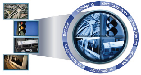 Figure 1. Illustration. Integrated corridor management involves viewing corridor assets – such as freeways, arterials, and transit – through a common lens. Source: Federal Highway Administration INTEGRATED CORRIDOR MANAGEMENT FUNDAMENTALSICM combines two fundamental concepts: active management and integration. Active management involves monitoring and assessing the performance of the system and, at the same time, dynamically implementing actions and providing services in response to fluctuations in demand. In an ICM corridor, all individual facilities and services must be actively managed so that operational approaches can be altered in real-time in response to an event anywhere on the system. An important element of active management entails providing information both to system operators as well as to system users to enable them to make the most informed decisions and choices. Integration requires actively managing transportation system assets in a unified way so that actions can be taken to benefit the corridor as a whole, not just a particular section or mode. Integration occurs along three dimensions:
Active and integrated corridors can be viewed along a hypothetical continuum, as shown in Figure 2, which is meant to depict a shift towards the desired end state of both active and integrated. For example, some corridors may actively manage some or all of their assets, but not in an integrated way. The ultimate goal of ICM is for corridors (represented by dots) to progress along the continuum to become as active and integrated as possible. 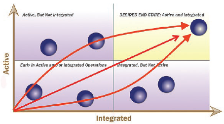 Figure 2. Illustration. The active and integrated continuum. Source: Federal Highway Administration THE INTEGRATED CORRIDOR MANAGEMENT RESEARCH INITIATIVEThe United States Department of Transportation (USDOT) started the ICM Research Initiative in 2006 to explore and develop ICM concepts and approaches and to advance the deployment of ICM systems throughout the country. Initially, eight pioneer sites were selected to develop concepts of operations (ConOps) and system requirements for ICM on a congested corridor in their region. Three of these sites went on to conduct analysis, modeling, and simulation (AMS) of potential ICM response strategies on their corridor. In the final stage, two sites – the US-75 Corridor in Dallas, Texas and the Interstate 15 (I-15) corridor in San Diego, California – were selected to design, deploy, and demonstrate their ICM systems. What could an integrated corridor management (ICM) response plan look like? A major incident has occurred on the freeway in an ICM corridor. Travelers are advised via dynamic message sign and other traveler information sources (e.g., 511) to take a parallel route or shift to alternative modes, where there is spare capacity. Signal timing on the parallel route is changed to better manage the flow of the detoured traffic, and transit operators prepare for the increased volumes by adding more buses along the impacted route. The Dallas and San Diego demonstrations "went live" in the spring of 2013. Each demonstration has two phases: design and deployment, and operations and maintenance. Both sites chose to develop a decision support system (DSS) as a technical tool to facilitate the application of institutional agreements and operational approaches that corridor stakeholders agreed to over a rigorous planning and design process. Though the DSS approach at each site differs slightly, the basic process is similar. The DSS gathers traffic data from an array of intelligent transportation systems (ITS) in the network and uses this information to forecast future conditions on the corridor. If an event (recurring or non-recurring) occurs that is predicted to meet pre-established congestion thresholds, the DSS generates response plans. These plans contain combinations of multimodal strategies to address specific congestion scenarios. Response plans are based on detailed business rules that establish the conditions under which assets can be used, which may vary based on the magnitude of the event, time of day, congestion levels on the network, etc., as well as by policy constraints. The DSS recommends and ranks response plans by running a simulation to determine which plan will most effectively address the congestion. Operating agencies are alerted to either accept or reject the plans; if accepted, the plan will be implemented. The USDOT is conducting independent "before-after" analyses to evaluate the benefits of ICM on transportation operator situational awareness, response and control, traveler information and overall corridor performance at each site. The experiences and lessons learned from the demonstration sites are being actively shared with the transportation community so that regions interested in ICM can leverage the knowledge gained to better shape a successful deployment for their corridor(s). Although the demonstration sites provide valuable insights into the necessary components of building an ICM system, they do not represent the only way to implement ICM. There is no "one-size-fits-all" approach to ICM, since the circumstances of a particular corridor will vary based on traffic patterns, agency dynamics, available assets, and a host of other factors. TRANSIT AT THE INTEGRATED CORRIDOR MANAGEMENT DEMONSTRATION SITESBoth ICM demonstration sites currently incorporate transit into their ICM approaches. In Dallas, the Dallas Area Rapid Transit (DART), which operates light rail and bus transit service in Dallas County, led the design and implementation of the ICM project. In San Diego, Metropolitan Transit System (MTS) is a key ICM stakeholder, and bus rapid transit (BRT) on I-15 is incorporated into ICM response plans. 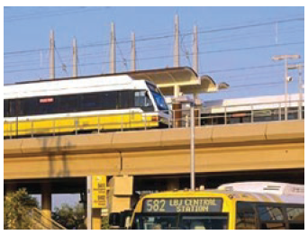 Figure 3. Photo. Dallas Area Rapid Transit, which operates the light rail and bus transit systems in Dallas, Texas, led the design and implementation of the integrated corridor management system on U.S. 75 in partnership with other regional agencies. Source: Dallas Area Rapid Transit. At both sites, transit primarily serves as an alternate mode to shift travelers to in response to significant congestion on the road network (i.e., due to an incident). Transit and roadway agencies mutually benefit from improved situational awareness in this arrangement due to enhanced monitoring capabilities and information sharing across agencies and jurisdictions. ICM agencies are also able to push the information they share with each other out to travelers. Dallas and San Diego developed integrated smartphone apps so that travelers can make better trip planning decisions along the ICM corridors by using multimodal information, not just roadway travel times. For transit agencies, this means customers have access to real-time information on bus or rail arrival times. This is an added benefit to regular transit riders, and a potential way to attract new riders who would otherwise not consider transit. AMS results showed that ICM could increase transit utilization by encouraging travelers to shift from driving to transit, especially during incident conditions; however, "parking expansion to accommodate this utilization appears to be a critical enabler of this benefit."2 Therefore, Dallas and San Diego added parking spaces as part of their ICM approaches. The sites also provide information on parking availability at transit stations so that drivers who experience congestion en-route know whether they can park their car in a nearby lot and take transit. Although transit stakeholders at the demonstration sites have indicated that a more comprehensive picture of travel along the corridor has been helpful, there is potential to increase the role of transit in ICM at the sites. Currently, only a major event on the network initiates a response that would shift travelers to transit. Neither site incorporates transit-triggered response plans into their approach. For example, if a major rail line shuts down, the ICM system does not recommend alternate strategies to move impacted passengers through the corridor. As part of its integrated corridor management (ICM) project on I-15, the San Diego Association of Governments (SANDAG) developed a smartphone application called 511 San Diego that makes multimodal, actionable traveler information available to the public, including:
The application also includes an optional text-to-speech feature and look-ahead commands that alert travelers to take alternate routes or modes to avoid congestion along their route. While the application is currently focused on the I-15 ICM corridor, SANDAG hopes to expand the program to other transportation corridors in the region. Source: http://511sd.com/app.aspx You may need the Adobe© Reader© to view the PDFs on this page. 1 U.S. Department of Transportation, Intelligent Transportation System Joint Program Office, Integrated Corridor Management Concept Development and Foundational Research, FHWA-JPO-06-034 (Washington, DC: JPO, 2006). Available at: http://ntl.bts.gov/lib/jpodocs/repts_te/14273.htm. [ Return to footnote 1. ] 2 U.S. Department of Transportation, Intelligent Transportation Systems Joint Program Office, Integrated Corridor Management Modeling Results Report: Dallas, Minneapolis, and San Diego, FHWA-JPO-12-037 (Washington, DC: JPO, 2012), p. A-4. Available at: http://ntl.bts.gov/lib/54000/54300/54346/ICM_Modeling_Results_Report__FHWA-JPO-12-037_.pdf. [ Return to footnote 2. ] |
|
United States Department of Transportation - Federal Highway Administration |
||