Appendix A - Survey Results
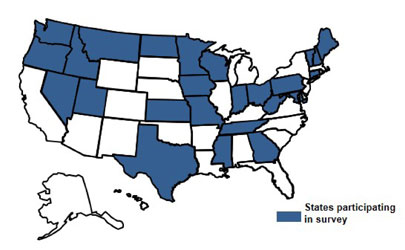
Question 1: Agencies Participating in Survey
Survey contributors were asked to enter the name of the agency they represented.
Responses were received from the following twenty-five (25) states as shown in Figure 2.
- Connecticut
- Georgia
- Idaho
- Indiana
- Iowa
- Kansas
- Maine
- Maryland
- Minnesota
- Mississippi
- Missouri
- Montana
- Nevada
- New Hampshire
- North Dakota
- Ohio
- Oregon
- Pennsylvania
- Tennessee
- Texas
- Utah
- Vermont
- Washington State
- West Virginia
- Wisconsin
Question 2: Agencies Using RCRS
Survey contributors were asked if their agency is using a RCRS.
Respondents from twenty-three (23) of the states that responded indicated that their agency uses a RCRS. Respondents from the following two (2) states indicated that they are not using a RCRS:
- New Hampshire Department of Transportation (DOT)
- Georgia DOT (Note: Georgia DOT responded ‘Yes’ to the follow-up question that would indicate they use an RCRS, but did not complete additional questions.)
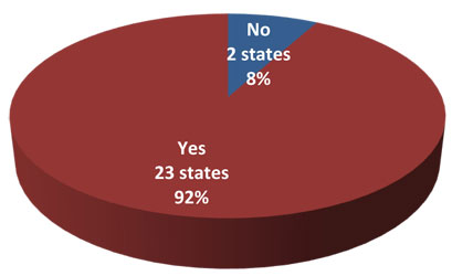
Question 2: Is your agency using RCRS?
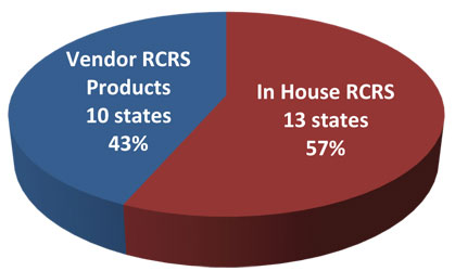
Question 3: Type of RCRS Used
Survey contributors were asked which RCRS they are using.
Respondents from thirteen (13) states indicated their RCRS was developed in house. Respondents from nine (9) states indicated use of vendor RCRS products.
| RCRS Product |
State |
|
In-House |
- Connecticut
- Kansas
- Maryland
- Mississippi
- Missouri
- Montana
- North Dakota
- Ohio
- Oregon
- Pennsylvania
- Tennessee
- Vermont
- Washington
|
|
Volt Delta |
|
|
Transcore TranSuite ATMS |
|
|
Open TMS – Open Roads Consulting Inc. |
|
|
Condition Acquisition Reporting Systems (CARS) – Castle
Rock |
- Idaho
- Indiana
- Maine
- Minnesota
|
|
Lonestar |
|
Question 3: What RCRS is your agency using?
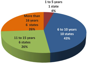
Question 4: Duration of RCRS Use
Survey contributors were asked how long their agency has been operating RCRS.
Respondents in six (6) states have been operating their RCRS between 11 and 15 years and respondents in ten (10) states have been operating their RCRS between 6 and 10 years.
| Number of Years Operating RCRS |
State |
|
1 to 5 years |
|
|
6 to 10 years |
- Connecticut
- Idaho
- Indiana
- Maine
- Missouri
- Ohio
- Pennsylvania
- Tennessee
- Utah
- Washington
|
|
11 to 15 years |
- Iowa
- Kansas
- Minnesota
- Mississippi
- Oregon
- Vermont
|
|
More than 16 years |
- Maryland
- Montana
- Nevada
- North Dakota
- Texas
- Wisconsin
|
Question 4: How long has your agency operated a RCRS?
Question 5: RCRS Changes
Survey contributors were asked if they have made any significant changes to their RCRS since it initially launched.
Twenty-one (21) responses were received to this question. Half of the respondents indicated that they have deployed a second generation RCRS and have used the same developer for both versions. Approximately one-fourth of the responders indicated that they switched to a new vendor and/or software systems since their initial RCRS launch. One (1) state respondent (West Virginia) indicated that their RCRS is a first generation system. Overall comments received indicate that changes are needed to continually evolve and improve RCRS. Specific comments received on the history of RCRS in some states included:
- Pennsylvania DOT, which uses an in-house RCRS, implements 3 to 4 enhancements per calendar year to their system. Maryland has been adding 2 to 3 major releases to their RCRS each year since 2006.
- Oregon DOT’s new RCRS version is integrated with their dispatch/incident management system. This new system avoids duplicate entry into both systems.
- The Vermont Agency of Transportation initially deployed CARS for their RCRS. In 2012 an in-house system was developed by Vermont while working with New England states on a new regional RCRS.
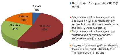
Question 5: Have you made any signifcant changes to your RCRS since you intially launched it?
Question 6: RCRS Data Received
Survey contributors were asked what data is received by their agency’s RCRS.
Respondents in over nineteen states indicated that construction activities, roadway or lane blocking incidents, and road weather observations were received by their agency’s RCRS. Ten respondents indicated that their RCRS received travel time information.
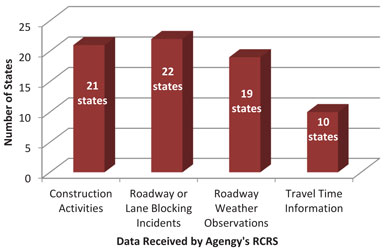
Question 6: What data is received by your agency's RCRS?
Other data received by RCRS noted by respondents included:
| Other Data/Information Received by RCRS |
State |
|
Chain Requirements |
|
|
CCTV |
|
|
DMS |
|
|
Special Event Information |
|
|
Road Conditions |
|
|
Load/Truck Restrictions |
- Iowa
- Minnesota
- Montana
- Oregon
|
|
Speed Restrictions |
|
|
Weather Radar |
|
|
Wind speed |
|
|
Maintenance Activities |
|
|
Non-blocking Incidents |
|
|
Travel and Tourism |
|
|
Point Speed Detection |
|
|
Automated Vehicle Location from State Vehicles |
|
|
RWIS |
|
|
Impaired Traffic Signals |
|
|
National Weather Service |
|
|
Traffic Speeds |
|
Question 7: RCRS Data Entry
Survey contributors were asked how data received by RCRS is entered (manual, semi-automated or fully automated).
Respondents indicated that travel times received by RCRS are fully-automated. Respondents noted that construction activity data received by RCRS are manually entered and semi-automated. Respondents indicated that roadway or lane blocking incidents and roadway weather observations data is received by RCRS by manual data entry, semi-automated systems, and fully-automated systems. A summary is provided in the table below.
Respondents noted that CCTV, DMS, traffic speeds, radar and wind speeds are an automated entry into some agencies RCRS. Manual entries noted by respondents for some RCRS included chain requirements, special events, truck restrictions and maintenance activities.
| Data Received by RCRS |
Manual Entry |
Semi-Automated Entry |
Fully Automated Entry |
|
Construction Activities |
20 states
ID, IN, IA, KS, ME, MN, MS, MO, MT, NV, ND, OH, OR, PA,
TN, TX, VT, WA, WV, WI |
2 states
CT, MA |
0 states |
|
Roadway or Blocking Incidents |
17 states
ID, IN, IA, KS, ME, MS, MO,MT, NV, ND, OH, OR, PA, TN, TX,
VT, WA |
3 states
CT, MA, WI |
2 states
MN, WV |
|
Roadway Weather Observations |
12 states
ID, IN, IA, KS, ME, MO, ND, PA, TN, TX, UT, WI |
3 states
MA, MI, VT |
3 states
OH, OR, WA |
|
Travel Time Information |
0 states |
0 states |
12 states
ID, KS, MA, MI, MN, NV, OH, OR, TN, TX, WA, WI |
Question 8: RCRS Data Frequency
Survey contributors were asked how frequently the data is received by their RCRS.
In order to understand each respondent’s ability to meet the SAFETEA-LU Section 1201 Real-Time System Management Information Program (RTSMIP) requirements, the survey asked responders to indicate the frequency at which different data types are updated in the RCRS. The following table describes the Section 1201 requirements.
Section 1201 Requirements Overview
| Data Received by RCRS |
Interstates – Outside Metro |
Interstates – Within Metro |
Metro Area Routes of Significance |
|
Construction Activities |
20 minute latency from time of closure |
10 minutes latency from time of closure |
10 minutes latency from time of closure |
|
Roadway or Blocking Incidents |
20 minute latency from time of verification |
10 minute latency from time of verification |
10 minute latency from time of verification |
|
Roadway Weather Observations |
20 minute latency from observation |
20 minute latency from observation |
20 minute latency from observation |
|
Travel Time Information |
N/A |
10 minute latency from calculation |
10 minute latency from calculation |
Respondents indicated that data (construction activities, roadway or lane blocking incidents, roadway weather observations, and travel time information) is most frequently updated within 10 minutes of observation as show in the table below.
| Data Received by RCRS |
Within 10 minutes of observation |
Within 20 minutes of observations |
On a regular schedule, regardless of whether conditions
change |
Daily |
|
Construction Activities |
12 states
CT, IA, IN, MA, MO, MS, ND, OH, OR, TN, VT, WI |
0 states |
3 states
ME, MT, WI |
5 states
KS, MN, TX, WI, WV |
|
Roadway or Blocking Incidents |
16 states
CT, IA, ID, IN, MA, MN, MO, MS, ND, NV, OH, OR, TN, TX,
VT, WI |
4 states
KS, ME, MT, WV |
0 states |
0 states |
|
Roadway Weather Observations |
11 states
IA, IN, MA, MO, MS, ND, NV, OH, OR, TN, VT |
3 states
KS, MT, TX |
6 states
IA, ID, MN, UT, WI, WV |
0 states |
|
Travel Time Information |
9 states
ID, MA, MS, NV, OH, OR, TN, TX, WI |
|
1 state
MN |
|
Question 9: RCRS Data Sources
Survey contributors were asked to identify what sources of data are used for their RCRS.
Respondents were asked if their RCRS data was received from the agency’s network, other agencies, the private sector or travelers. Most responded that data is received from the agency network and only a few identified travelers as a data source for construction, incidents and roadway weather conditions.
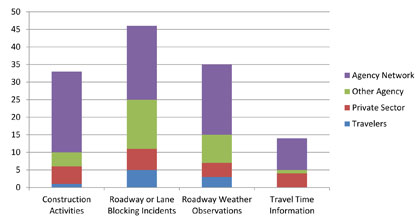
Question 9: From what source does your RCRS receive data?
|