2. Current TMC Operational Practices2.1. TMC Deployment ModelsThis section provides a description of the industry's most common TMC types and models in the United States. There are four (4) typical models:
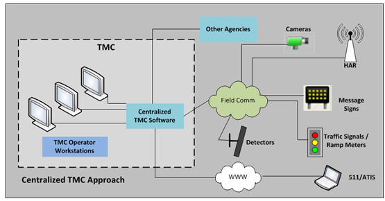
It is common for TMCs to use a "hybrid" approach combining characteristics of two or more models. A large number of TMC in the United States have implemented the hybrid model. 2.1.1. CentralizedThis model is usually managed by a single entity and it has straightforward lines of authority as well as established goals and objectives. Typically, the operational focus is based on local area issues, although coordination with neighboring agencies may still be necessary depending on existing inter-agency agreements. This approach can be located within the existing agency's facility and it can be staffed with in-house personnel. However, operations can also be outsourced under the supervision of the agency. In a centralized model, all systems reside in one location or datacenter (typically the TMC facility). This includes domain authentication services, email, applications, shared files and field devices. Remote sites can still have access using Thin Client devices and bandwidth-friendly enables (e.g., virtual private network (VPN) technology). Benefits include lower capital and operational costs, greater data security (all data is stored in a secured datacenter), less backup complexity, co-location of all equipment (e.g., hardware) at one site, and minimized risk areas (e.g., internet access). The disadvantage of this model is that the remote's sites WAN connection could be a point of failure. Typically, there are two implementation approaches:
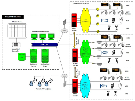
Figure 1. depicts a typical network architecture for this model.
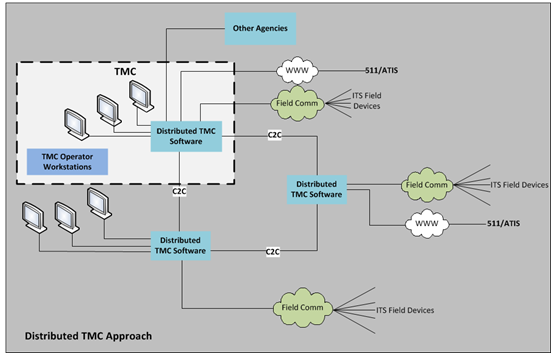
2.1.2. Distributed/DecentralizedThis model is a joint program where various agencies reach agreement on policies and practices, structure, funding, staffing, asset sharing, and delineated roles for each agency. Generally, this operational model is applied to larger metropolitan areas that cross several jurisdictional boundaries. In this model, systems and staff reside in multiple locations/TMCs and certain functions or capabilities are distributed or shared between various centers. This arrangement provides agencies with the ability to maximize resources, increase efficiency, improve working relationships, and share costs. In this model, each site is mostly self-sustained, although some connectivity to the primary datacenter is required. However, each site is able to hosts its own email server, manage applications, control its internet access, and host its own shared files. The TMC may have virtual control provided through the shared implementation of a wide-area network (WAN). Localized management of signals and other traffic control elements ensures that the WAN is used for information and coordination rather than actual operations. The benefit of this model is that there is no single point of failure as each site can survive on its own. The disadvantage of this model is cost as it requires additional hardware and software as well as support for each site. Figure 2 depicts a typical network architecture for this model.
2.1.3. VirtualThis model may be applied in varying degrees to other operational models, or it may be deployed entirely on its own. Moreover, it needs to be supported with the appropriate ITS and communication infrastructure, and system security. If deployed on its own, the most common operational approaches include:
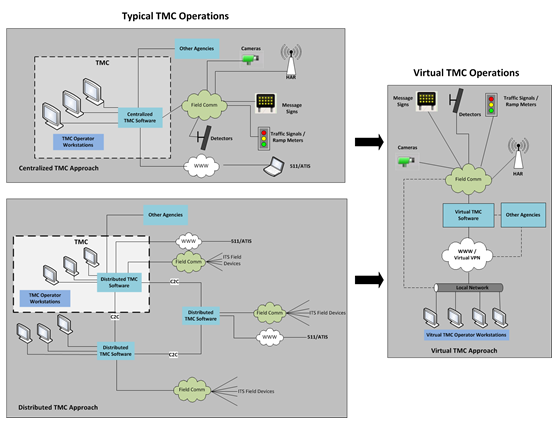
Depending on the jurisdiction, scope, operational approach and geographical area being covered, it may require extensive coordination and cooperation from participating agencies and stakeholders, as well as inter-agency agreements. Virtual access to the system may include both agency and interagency personnel. Under this model, costs may be shared among the participating agencies or may be funded by a single entity. Figure 3 provides a comparison of the Virtual TMC model alongside the two most common traditional models (Centralized and Distributed).
2.1.4. Hybrid: VirtualThis model can be further divided into: Hybrid Centralized and Hybrid Distributed. The operational focus may cover an extended geographical area, which may include urban and rural regions. In the Centralized version, all users are part of the same entity and share the same network. The main difference is that the network can be accessed via intranet or VPN. For example, District offices may be allowed to enter their own information (e.g. weather information collected from RWIS), manage their own events, etc. In the Distributed version, the ATMS or any data input system is browser-based and accessible on the internet via Hypertext Transfer Protocol Secure (https) communication protocol. Users are able to log into the system from any place with internet connectivity. Access to the system will depend on privilege levels assigned to each user. Currently, the majority TMCs in North America have virtual capabilities. However, in most instances these have been established for Emergency Operations or as Backup Operations rather than as a stand-alone hybrid model. In addition, typical TMCs are also managed based on their geographic area covered. The range and scope of the geographic service area of a traffic management center is dependent upon institutional, political, and economic considerations as well as the transportation management needs of the area. Figure 4 depicts one of the hybrid models currently deployed in the United States.
Figure 5 depicts the other hybrid model currently deployed in the United States.
2.2. Geographic Area Covered6As noted on the TMC Business Planning and Plans Handbook TMCs may serve single jurisdictions, multiple jurisdictions within a metropolitan area, a large region, or even an entire state. The following terminology is used when describing the various models:
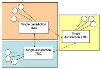
2.2.1. Single Jurisdiction TMCSingle-jurisdictional TMCs represent the least sophisticated business model arrangement. They serve a single city or county, typically are located in an office area of an existing facility such as a city hall or at the county department of transportation offices. In metropolitan areas with multiple jurisdictions, virtualization may help enable handoffs and coordination of operations with other TMCs through dedicated communications lines and networks. Figure 6 depicts interaction among single jurisdiction, each responsible for their own ITS equipment (represented as circles in the figure below).
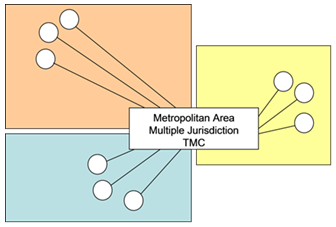
2.2.2. Multiple Jurisdictions TMCThe multi-jurisdictional TMC controls ITS field elements in multiple jurisdictions (e.g. cities, counties), irrespective of political boundaries. Consequently, the number of miles of roadway, number of ITS elements, and the number of stakeholders is significantly larger than would be found in a single jurisdiction TMC arrangement. Figure 7 depicts a TMC that controls ITS devices (represented as circles in the figure) and operates across political boundaries focusing on an entire metropolitan area.
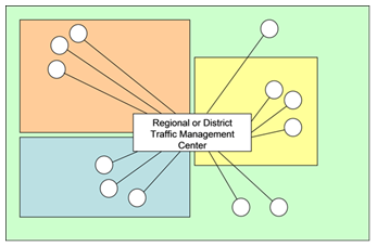
2.2.3. Regional or District TMCThe regional or district TMC business model expands upon the multi-jurisdictional model in that it encompasses additional non-metropolitan areas such as county or state facilities outside of a metropolitan area, in addition to the multiple jurisdictions within the metropolitan area. The mission of a Regional or District TMC may include not only urban arterial traffic management, but also the operation and management of suburban, urban freeway, and rural highway and interstate facilities. Figure 8 illustrates that the geographic area of a Regional or District Area may coincide with DOT districts, metropolitan planning areas, or other defined geographic boundaries.
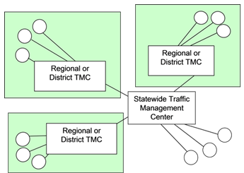
Virtualization of TMC functions benefits this model in particular by providing a means for mutual access to common systems and for remotely managing other systems (for instance rural systems that may not operate 24-7). 2.2.4. Statewide TMCA statewide TMC is typically initiated by the State DOT, whose geographic service area encompasses the entire State. Some of these TMCs are operated by a single agency, while others have received participation from other state agencies such as the State Highway Patrol. A Statewide TMC can be implemented in a number of ways. The primary differentiator between the various alternatives is the level and scale of central control of the Statewide TMC. Typically, rural areas are monitored and managed by the Statewide TMC while metropolitan areas are under the supervision by Regional/District TMCs. Figure 9 is an illustration of a statewide TMC that controls and monitors ITS devices statewide while a Regional TMC still has control over its own area.
2.3. Number and Type of Agencies Involved11The number and type of agencies (such as a DOT, public works, or public safety agency) involved in the TMC significantly affects the functions and activities of the TMC. A number of different business models are available for TMCs relative to the number and types of agencies involved in the TMC planning and operation. Furthermore, multiple disciplines from a single agency may be participants in the TMC. 2.3.1. Single Agency TMCThe most common implementation of a TMC serves a single city, one county, or one state. The simplest of these single-jurisdictional TMCs, as described in the previous section, will likely include only a single agency or discipline within that jurisdiction. Typically, this would be the traffic engineering agency within a given city or county. Many of the same benefits that apply to a single jurisdiction TMC are applicable to the single-agency TMC model. 2.3.2. Multiple Transportation AgenciesA more sophisticated TMC model arises when transportation agencies from multiple jurisdictions come together to operate a single TMC. An example might be that the DOTs from two or more cities cooperatively join forces to sustain one TMC to handle both jurisdictions' transportation management needs. Such an arrangement may or may not include the police or emergency management personnel. Many of the benefits of the multiple-jurisdictional TMC are also applicable to the Multiple Transportation Agencies model. 2.3.3. Multiple Agencies and DisciplinesThe Multiple Agencies and Disciplines TMC model is perhaps the most sophisticated, and as a result the most difficult to implement, but provides the highest potential payoff in terms of improved transportation operations throughout a region. Many of the same benefits of a multi-jurisdictional TMC model are also applicable to the multiple agencies and disciplines model. In this TMC business model, the transportation department, public safety department, emergency management department and transit department, or a combination of these agencies, shares a common facility. The agencies may be from the same jurisdiction, or from multiple jurisdictions. The most typical combination of these agencies includes the collocation of the transportation department and the public safety agency within a single TMC. Transportation and public safety are particularly complementary because of the overlap in their missions – to improve the safety of the transportation system, of which incident management is a core component. Logistically, the partner agencies are responsible for a common jurisdictional area. As an example, a State DOT could co-locate with the State Highway Patrol, while the city traffic engineering department co-locates with the local police department. Historically, emergency management personnel (e.g., fire department) tend to be separate and only in rare instances are they known to co-locate with the transportation and public safety agencies. To help bridge this separation, more and more agencies are providing virtual connections between transportation and emergency management through integrated CAD systems and dedicated communications links so that critical information, including video images, can be shared. Multi-agency TMCs yield significant user, institutional, and system operations benefits. 2.4. Interview of Current Deployed ModelsIn order to achieve a better understanding of the current practices related to TMC Virtualization, various transportation agencies including DOTs were interviewed to determine their approaches to setting up and operating their facilities. Ten agencies were interviewed for this guidebook. The questionnaire supplied to them contained 18 questions which were used as input for the information shown in this report. The questions were organized into the following categories:
Personnel at the following agencies were interviewed:
A summary of the questionnaire responses are included in Appendix C. 2.5. Profile of the Agencies Reviewed2.5.1. Alabama Department of Transportation
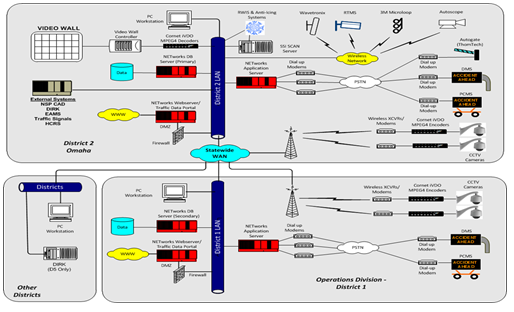
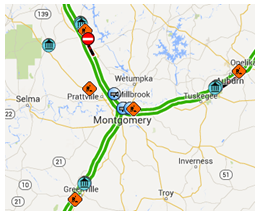
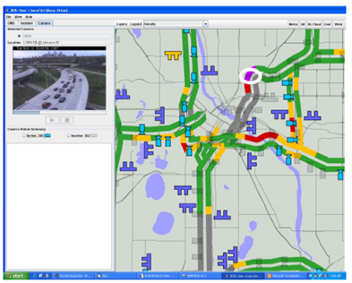
The Alabama Department of Transportation (ALDOT) is organized into nine geographic regions called Divisions, with a Central Office located in Montgomery. Deployment and OperationsThere are 140 miles of Interstate Highways around the Montgomery Region. Currently, the traffic control center oversees 350 traffic signals and red light cameras plus 50-60 CCTVs. ALDOT recently procured an ATMS system, which is browser-based and can be managed virtually. TMC operations staff and those with user privileges (e.g., supervisors, maintenance staff) will have the ability to perform all ATMS activities remotely. However, due to ALDOT's network security and rules the ATMS won't be accessible via VPN. The current VPN connection has a 22 minute delay and it needs to be upgraded. Figure 10 shows a snapshot of ALDOT's traffic conditions in Montgomery County, which is available through the ALDOT's website. Initiatives
ALDOT is gearing up to open its new Statewide Regional Traffic Management Center (RTMC) in mid-2014. It is planned that the center would cover the road network for the entire state; however, during the initial launch only the Montgomery region and eight adjacent regions in the Southeast corner of the State will be covered. The TMC will operate from Monday-Friday 6am-6pm with morning and afternoon shifts. At the opening of the RTMC, operations will not be shared or co-located with any other public agencies, although there is a possibility of doing so in the future with the Department of Public Safety and Highway Patrol, the latter operates 24/7. Operational sharing with the Highway Patrol may provide the RTMC the opportunity to operate around the clock. The RTMC vision is to have an ATMS with virtual functionality in real time at a statewide level. The flexibility of ALDOT's ATMS system is that it can be operated remotely. This option may become available once the complete set of performance measures has been identified and coverage expands beyond the original 12 hrs. /day, 5 days/week. ChallengesThe biggest challenge that the RTMC faces is sharing the network with the rest of ALDOT, which requires authentication through the existing firewall. The ideal situation would be to have two separate networks, with one being for the exclusive use of the RTMC, since it has a set of needs that are distinct from those of the rest of the agency. Ideally, the separate network would allow for ISP service, and user identification/authorization would be made easier yet still be secure. 2.5.2. Los Angeles CountyLA County operates signals for a number of cities and unincorporated cities within the county. The TMC is located in Alhambra and it operates Monday through Thursday from 7am to 5:30pm. The Department is the hub for the Traffic Control System in the County. LA County also has a center-to-center connection to other cities, where they do not control those cities' signals, but have viewing capabilities and share data. Table 5 provides a snapshot of the number of cities participating in the program.
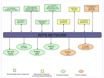
Deployment and OperationsThe system in place is thick client-based with VPN access. It is in a virtual server platform with a terminal server setup. The system may be accessed remotely, although it is mainly used by maintenance crews and the cities that want access to it. LA County has in place a substantial wireless radio network, which is monitored by their contractors, field maintenance crews, and the department's IT staff. This is not a traditional TMC, and staff does not have the authority to make decisions regarding timing signals. If changes are needed, they must be approved first by the responsible staff at each agency. If LA County staff discovers an issues requiring immediate attention, operators contact the County Dispatch. In turn, County Dispatch notifies field crews. The agencies are also responsible for the maintenance of their system. However, in unincorporated areas operators can make changes to the signals based on their privileges at the TMC. Information is provided to operators by signal timing experts working on synchronization projects. There are two agreements in place with each of the participating agencies: a VPN Access Agreement and a City Cooperative Agreement. ChallengesSome of the challenges experienced at the beginning of the program were related to executing agreements with the cities and coordinating implementation with each agency's IT department. 2.5.3. Metro Regional Integration of ITS (RIITS)The Los Angeles County Metropolitan Transportation Authority (Metro), sponsors the Metro Regional Integration of ITS (RIITS) network.13 A number of agencies including Caltrans, City of Los Angeles Department of Transportation (LADOT), California Highway Patrol (CHP), Long Beach Transit (LBT), Foothill Transit (FHT) and Metro contribute information collected through their own Intelligent Transportation Systems to the network using the Los Angeles County Regional ITS Architecture and National ITS Standards. Table 6 shows the number of agencies (125) that participate in the RITTS program.
Deployment and OperationsThe RIITS network supports information exchange in real-time between freeway, traffic, transit and emergency service agencies to improve management of the Los Angeles County transportation system and better serve the traveling public. RIITS also provides data to traveler information services of all kinds, which allows them to reach the widest possible audience. RIITS is a unique system that combines the data of 125 agencies in the region. It is in essence the largest transportation system in the United States. The program ensures that agencies are able to provide their data to the system by advising each agency of the required hardware and software (e.g. networks, servers, applications (APIs)), and by providing training to IT staff. Uptime for RIITS is 88 percent, although the system is currently being updated, and the new goal is to have RIITS up for 99.5 percent of the time. RIITS does not operate as a traditional TMC; there are no RIITS operators. RIITS is rather a fully automated system (virtual) running 24/7. Each agency is responsible for providing its own data to RIITS. The system collects events, incidents, scheduled events, freeway performance, real-time transit, arterial traffic signals, and timing plans from all the agencies mentioned above. The information is collected for the counties of Los Angeles, Orange, Ventura, Riverside, and San Bernardino. The system belongs to Metro, but the data belongs to each provider. RIITS is not a public facing system, the only component that has a Graphical User Interface (GUI) is the Event Entry section. The system is available through the internet but there is IP address security in place. It is configured to receive information from a number of pre-configured IP addresses. Event data entry does not reside at the same IP address where data is stored. Agencies can choose to enter their data manually instead of using automation. The system can be accessed through a URL on the web or via a mobile application (event entry capability). Agencies that have signed up for manual entry have access to the system 24/7. There are MOUs and Agency Agreements in place, as well as ISPS/Agency agreements. Figure 11 depicts the network's architecture.
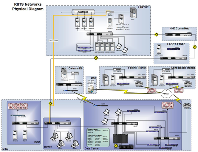
Figure 12 depicts the entire diagram of the network including the connection with other agencies.
2.5.4. Michigan Department of TransportationDeployment and OperationsThe Michigan Department of Transportation (MDOT) has four TMCs in the state: the South Eastern Michigan Transportation Operations Center (SEMTOC) in the Detroit Metro Region, the Statewide Transportation Operations Center (STOC) in Lansing, the West Michigan Transportation Operations Center (WMTOC) in the greater Grand Rapids area, and the Blue Water Bridge (BWB) TOC. The SEMTOC and Statewide TOC operate 24/7, while the other two TOCs operate only during busy travel times. The SEMTOC manages highway traffic in parts of the Metro Region (Wayne, Oakland, and Macomb counties). The West Michigan TOC manages highway traffic primarily within the region of Grand Rapids. The STOC manages traffic across the rest of the state. MDOT is using a browser based ATMS system, which allows devices to be remotely monitored and managed. The ATMS is owned by MDOT, but it was developed and it is maintained by a contractor. The ATMS provides integrated control of DMS, CCTV and VDS, as well as integrated Event Management and Response Plans (for DMS and Notifications). Michigan's TOCs coordinate response and disseminate information for activities on all MDOT-owned roadways. This includes urban, rural, and interstate facilities. There is coordination with other TOCs outside Michigan, and local TOCs within Michigan, but there are no formal agreements in place. The Michigan State Police dispatch and SEMTOC are co-located, and while they work together, there is no formal agreement in place for sharing information. The staff at the TOC is contracted and allowed to work alone during overnight shifts. Access to the ATMS system is provided to TOC and MDOT staff. However, there are other users that have access to view information only. MDOT has formal data and video sharing agreements with various agencies and companies, including the National Weather Service (NWS), plus many media stations and other traffic information providers. All centers cover over 1,247 freeway miles, 652 US route miles, and 171 State route miles. Operations staff mange 85 CCTVS (with plans to have about 130 more implemented by the end of 2014) and 190 DMSs. The network is monitored by TOC management. ChallengesSome of the biggest challenges implementing virtual capabilities have been network integration and device communication issues. 2.5.5. Minnesota Department of TransportationDeployment and OperationsThe Minnesota Department of Transportation (MnDOT) has in place a Regional Transportation Management Center (RTMC) comprised of three functional areas all co-located at the center:
MnDOT Metro Maintenance Dispatch and Freeway Operations staff cover the Twin Cities Metro Area. Freeway Operations covers urban freeways in the Twin Cities Metro Area. These roads are interstates, US routes, and State routes. The Minnesota State Patrol Dispatch covers the northern 2/3 of the state including the Twin Cities Metro Area. In the Twin Cities, cameras and detection cover about 500 miles of freeways. The State Patrol has another dispatch center in Rochester for the southern 1/3 of the state. There is an ATMS system in place called IRIS, which is open source software developed in-house by MnDOT. The TMC supports onsite and remote control of the CAD system, ramp meters, CCTVs, DMS and lane control devices (See Figure 13). IRIS also allows for streaming video from MnDOT's cameras and camera control. Even though the IRIS system allows for virtual capabilities, in practice MnDOT continues to maintain staffing at the RTMC. RTMC operators have remote access to IRIS, but at this time only supervisors use the system remotely. Local media have IRIS access to cameras only and use the system to switch camera feeds. The virtual capabilities could be utilized in an emergency should the RTMC be non-functional.
2.5.6. New Hampshire Department of TransportationDeployment and OperationsThe New Hampshire Department of Transportation (NHDOT) has in place a 24/7 Statewide TMC. The TMC covers all NH routes throughout the state.
The TMC's scope includes functions that are atypical of a TMC, such as a statewide dispatch and call center that monitors environmental systems and manages construction work zones. The TMC is also responsible for maintenance dispatch operations and roadside assistance dispatching duties. NHDOT has in place a browser-based ATMS system. District offices can access the ATMS only through the NHDOT VPN connection. All District Offices have been granted access to the ATMS with privileges to view other regions' information. At each District office one operator has access to input information into their Weather Module. District offices are open 24x7 from December to March, and weather data is input on the hourly basis. From April to November, the offices are open only during regular office hours and weather data is input five times per day. Some of the servers are virtualized. Network monitoring is performed in house by the DOT's IT Department.
2.5.7. Oregon Department of TransportationDeployment and OperationsThe Oregon Department of Transportation (ODOT) has in place a 24/7 statewide TMC, which covers the Portland Metropolitan and surrounding counties, including part of Wheeler County. 
The TMC scope of work includes monitoring and managing freeways, arterial roads and roads owned my ODOT. The TMC operates CCTVs on freeways and arterial roads, controls VMS, deploys traffic signals, monitors mountain passes and rural areas, and monitors a queue warning system, VSL, and travel time and curve warning systems (interchange between rural and urban area). In addition, operators also send traffic updates and notifications to various media outlets. TMC operation responsibilities also include dispatching Incident Response Vehicles to all freeways and some arterials in coordination with 911 to determine appropriate response plans. ODOT has in place a browser-based ATMS system, which was developed by a private contractor with additional work being done to the system by ODOT and one of the local universities. The network and the system are monitored by ODOT's IT Department. The ATMS has virtual capabilities including system access and system operations. At this time, only ODOT personnel have access to the system, including two District Offices. These users are connected to ODOT's network and do not require VPN access to manage the ATMS. However, designated personnel can view the system remotely. Remote connection is possible through VPN access. The 911 system is not connected to the ATMS, but has shared access to the radio and CCTV feeds through the video switch. ODOT is working on a CAD interface. Figure 15 below depicts the ODOT's Architecture Interconnects for Portland Area TMC operations.
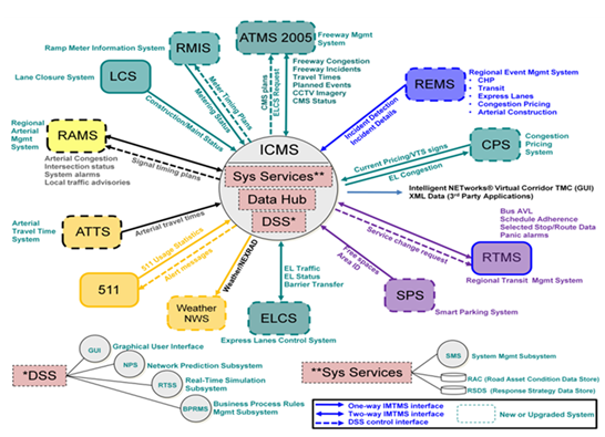
2.5.8. San Diego ICMSDeployment and OperationsThe San Diego Association of Governments (SANDAG), United States Department of Transportation (USDOT) and the California Department of Transportation (Caltrans) deployed the San Diego I-15 Integrated Corridor Management System (ICMS). This ICMS is one of two integrated corridor projects in the United States. The San Diego ICMS project is collaboration between SANDAG, local cities, and State and Federal transportation agencies to implement USDOT's vision that metropolitan areas can realize significant improvements in the efficient movement of people and goods through aggressive, proactive integration of existing infrastructure along major transportation corridors. It involves integration of technologies and concepts that have yet to be used in the United States. In San Diego, 13 agencies exchange data virtually through a data hub using a common application. The application is hosted in a third party data center. ICMS is a virtual system with no ICMS operators. The system is fully automated (virtual) and runs 24/7. Each agency provides data (input) and the system provides response plans (outputs) based on rules-based DSS, available assets, current and predicted traffic conditions and on-line Micro Simulation Analysis, as described in Figure 16 below.
Various Active Traffic Management (ATM) strategies were deployed to dynamically manage multiple facilities and modes along the corridor. These strategies include:
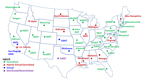
Each agency's operators can now take proactive steps to prevent system breakdown using enhanced controls across multi-jurisdictional devices, such as traffic signals, ramp meters and dynamic message signs. This groundbreaking method of transportation management enhances mobility, improves goods movement, provides better accessibility to services, and enhances safety. 2.6. Current TMC DeploymentsFigure 17 provides a snapshot of the different models deployed throughout the United States. The research shows that the most common approached used is the Centralized Model.
Table 7 shows the TMC model deployed by various agencies, as well as the geographic area covered at each TMC.
5 Nebraska Department of Roads (NDOR) District Operations Center Software Solution Deployment Plan, May 2007 [ Return to note 5. ] 6 FHWA, Transportation Management Center Business Planning and Plans Handbook (Washington, DC: 2005). Available at: http://tmcpfs.ops.fhwa.dot.gov/cfprojects/uploaded_files/TMC_BPG_Final.pdf [ Return to note 6. ] 7 Ibid., p. 4-3. [ Return to note 7. ] 8 Ibid., p. 4-4. [ Return to note 8. ] 9 Ibid., p. 4-5. [ Return to note 9. ] 10 Ibid., p.4-6. [ Return to note 10. ] 11 FHWA, Transportation Management Center Business Planning and Plans Handbook (Washington, DC: 2005). Available at: http://tmcpfs.ops.fhwa.dot.gov/cfprojects/uploaded_files/TMC_BPG_Final.pdf [ Return to note 11. ] 12 Alabama Department of Transportation Traffic Information and Cameras. Available at: http://alitsweb2.dot.state.al.us/its/ [ Return to note 12. ] 13 Los Angeles County Metropolitan Transportation Authority (Metro), "Regional Integration of Intelligent Transportation Systems" website. Available at: www.riits.net. Accessed April 6, 2014. [ Return to note 13. ] 14 Ibid. [ Return to note 14. ] 15 Los Angeles County Metropolitan Transportation Authority (Metro). RIITS Network Operations and Maintenance Manual. August 2014. [ Return to note 15. ] 16 Starr, Ray. (2008). Mn/DOT IRIS Software [PP slide 7]. Retrieved from the National Rural ITS Conference: http://www.nationalruralitsconference.org/downloads/Presentations08/MiniTraining_Open2.pdf [ Return to note 16. ] 17 New Hampshire Department of Transportation Traffic Management Center. Available at: http://www.nhtmc.com/ [ Return to note 17. ] 18 Oregon DOT System Architecture (Appendix C). http://www.oregon.gov/ODOT/HWY/ITS/pdfs/itsdocuments/vastitsplan/appc_systems_architecture.pdf [ Return to note 18. ] 19 San Diego Association of Governments (SANDAG). January 2014. ICMS System Architecture Document. [ Return to note 19. ] | ||||||||||||||||||||||||||||||||||||||||||||||||||||||||||||||||||||||||||||||||||||||||||||||||||||||||||||||||||||||||||||||||||||||||||||||||||||||||||||||||||||||||||||||||||||||||||||||||||||||||||||||||||||||||||||||||||||||||||||||||||||||||||||||||||||||||||||||||||||||||||||||||||||||||||||||||||||||||||||||||||||||||||||||||||||||||||||||||||||||||||||||||||||||||||||||||||||||||||||||||||||||||||||||
|
United States Department of Transportation - Federal Highway Administration |
||