Mitigating Work Zone Safety and Mobility Challenges through Intelligent Transportation Systems
Case Studies
CHAPTER 5 - MANAGING WORK ZONE TRAFFIC USING PERMANENT ITS: LAS VEGAS, NV
As noted in the previous chapter, many agencies have permanent intelligent transportation system (ITS) technology deployed throughout their jurisdictions for transportation management purposes. When road maintenance or rehabilitation/reconstruction occurs within or near these permanent deployments, agency staff can leverage these systems with other work zone mobility and safety efforts to minimize the impacts of the road work activity. This chapter provides an example of a multi-jurisdictional system developed for the Las Vegas metropolitan area to assist in managing traffic during construction and maintenance operations within its boundaries. While the previous chapter described efforts by the system operators to help manage traffic during a major high-impact freeway widening effort on a specific facility, this chapter emphasizes day-to-day efforts to support more typical routine construction and maintenance activities that commonly occur within a metropolitan area.
Overview of the System
The transportation management system in Las Vegas is termed the Freeway and Arterial System for Transportation (FAST). FAST comprises both a freeway group and an arterial street group. Local agencies handle basic maintenance needs of the arterial system components (signals, cameras for signal detection), and FAST handles the management and maintenance of closed-circuit television (CCTV) cameras, freeway traffic sensors, ramp metering, and changeable message signs (CMS). Overall, in 2012 FAST had approximately 1,000 devices in the field (sensors, cameras, signs, ramp meters, etc.), with another 200 slated for deployment.
FAST was officially initiated in 2000-2001, although the arterial street component had been around since the mid-1980s as the Las Vegas Arterial Control System (LVACS). FAST is funded through a combination of local sales tax to address arterial street management and the Nevada Department of Transportation (NDOT) to address freeway operations and management.
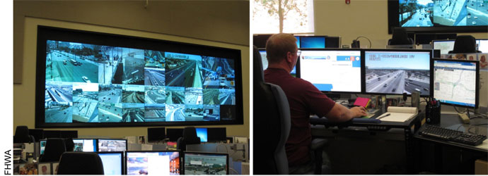
FAST is used to manage all types of traffic situations within the Las Vegas metropolitan area. The operations control room, shown in Figure 16, is staffed from 5 am to 11 pm Monday through Friday, and from 8 am to 11 pm Saturday and Sunday. Traffic incident management is one of the major functions of FAST, but special event management, management of recurrent traffic congestion, and traffic management during roadwork activities are also within FAST’s purview.
Applicability of the Engineering Design Process
Defining the Problem and Specifying Requirements of a Solution
From a technology perspective, FAST comprises many of the components that are commonly used to manage traffic in a metropolitan area. Plus, the ability to coordinate both arterial street and freeway operations gives FAST an advantage that few transportation management centers across the U.S. possess. In other words, FAST operators have a fairly wide range of tools at their disposal to help address construction and maintenance activity-related impacts.
Key Problems and Solutions
|
One of the key challenges that FAST operators face in assisting with construction and maintenance activity traffic impacts is how to be consistently integrated into the planning and scheduling efforts for these activities. FAST personnel note that while they are often notified about upcoming lane closures and full road closures so that appropriate advance notification messages can be displayed to travelers via the CMS, they also encounter situations in which they were not aware in advance of a lane closure and became aware of it through the normal CCTV monitoring efforts of the system by FAST operators. Once they notice that a lane closure is present, FAST operators can quickly deploy CMS messages upstream to provide additional warning to approaching motorists. However, there is less opportunity at that point to encourage route diversion or other responses by travelers.
Coordination between FAST and construction and maintenance work in the region extends beyond normal day-to-day lane closure notification to work zone planning, programming, and design decisions. As one example, a work zone ITS (consisting of temporary cameras, flow detectors, and portable changeable message signs to be deployed throughout the project) was procured and deployed during a previous I-15 design-build (DB) reconstruction effort north of the US 95 interchange where FAST monitoring and control were not yet present. FAST personnel had not been involved in specification development or procurement of the devices, so the system was not planned for integration with FAST. This limitation was addressed when the DB team later provided funding to FAST to allow them to integrate the data coming from that system into the FAST system. Funding was also provided to allow FAST operators to work overtime to focus specifically on the project area and help manage the temporary system.
Selecting, Designing, and Implementing the Best Solution
FAST provides a dissemination outlet of both advance notification and real-time roadwork-related traffic information via the roadside CMS and its website. FAST operators are trained to both identify the need for CMS messages and to properly design and post them. Certain roadwork activities may also require signal timing changes to support use of arterials as detour routes if either the freeway or another arterial is affected by work activity.
Most of the support from FAST involves posting work zone information on the CMS(s) upstream of the activity. For example, the operators may post a general warning message about lane closures on I-15 prior to, and during, the actual work operation, as depicted in Figure 17.
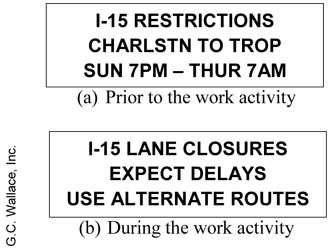
Specific diversion routes are typically not provided when a message such as this on a CMS. Rather, the intent is for drivers to decide on their best diversion route to take, given that a lane reduction exists on their intended route. There have been a few work zone projects performed in which FAST personnel modified both traffic signal and ramp metering timings (12). One such project was a 5.5 mile crumb rubber overlay project in Fall 2011 on I-15 between the US 95 interchange and the Tropicana Avenue interchange (see Figure 18). For this project, travel on I-15 was restricted to two lanes per direction between Sunday evening and Thursday morning on four consecutive weeks in September-October 2011. A continuous paving operation was also required on one weekend in October (Saturday and Sunday) to complete the job. During that weekend operation, only one lane per direction was maintained on I-15.

FAST personnel monitored cameras and flow detectors throughout the network during the project. In addition, they relied on Google© traffic maps to assess conditions on the key arterials where they lacked surveillance coverage. The reduced capacity of I-15 caused significant diversion to the arterial street system, with MLK Boulevard, Rancho Drive, and Valley View Boulevard serving as major diversion routes southbound, and Valley View, Decatur Boulevard, and Jones Boulevard serving as major diversion routes northbound. Significant increases in traffic also occurred on several of the east-west arterials providing access to I-15 and these north-south arterials. The actual amount of diversion on any of the routes varied day-to-day and hour-to-hour, presumably because of learning effects by drivers experimenting with various diversion alternatives. FAST personnel implemented numerous changes in existing signal timing plans over the course of the project, but found it difficult to establish an optimum timing plan due to the continuously changing travel patterns. One of the primary goals was to minimize “demand starvation” at any of the signals due to upstream intersection traffic signal timing problems. FAST personnel also strived to minimize impacts on the other movements at selected intersections upstream, within, or downstream of the project. In some cases, operators increased signal cycle lengths. In other cases, timing offsets and splits were adjusted.
Evaluation and Lessons Learned
Usage Statistics and Performance Evaluations
Work zone operations and safety have not been regularly or formally evaluated using data from FAST. There have been certain instances, such as the previously mentioned crumb rubber overlay project, where work zone impacts have been assessed using some of the FAST data. The potential effectiveness of the operational changes made on the crumb rubber overlay project was evaluated through post-hoc traffic simulation analyses. The analyses showed that the changes made did improve operations slightly over what would have occurred if the changes were not made. Overall, the changes were determined to have reduced delays by 9 percent and stops by 11 percent in the AM peak period. The benefits in the PM peak period were less pronounced, reducing stops by 3 percent but increasing delay by 15 percent relative to a no change condition.
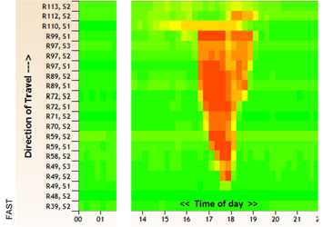
A key focus area of FAST management personnel is the monitoring of both safety and mobility conditions at all times within the network, and the organization of that data to allow quick and easy extraction of the data for time periods and locations of interest (such as during periods of roadwork activity). FAST personnel have three main sources of data available for monitoring traffic mobility along a particular route. First, speed data from the individual traffic sensors can be downloaded and analyzed to generate contour maps of speed ranges by location and time, as shown in Figure 19. The maps can be generated on multiple days and compared to assess changes in both duration and extent of any congestion that develops.
Both still images and real-time video segments of the CCTV views can also be captured and archived through FAST. Staff will occasionally use this capture and archiving process to check elapsed travel times on particular roadway segments. Personnel will select a unique, easily-identifiable vehicle at one camera location and time, and then look at a downstream camera location until that unique vehicle arrives. The elapsed time between the two camera view captures provides an accurate assessment of roadway segment travel time.
If conditions on a route not covered by surveillance equipment is of interest, operators will also access Google© traffic maps as another method of monitoring traffic conditions within the network. This approach was used during the I-15 overlay project in Fall 2011 to keep track of conditions on key arterials serving as alternate routes to I-15. FAST personnel noted that the data appeared to be fairly accurate and reliable for monitoring the extent of backups within the network.
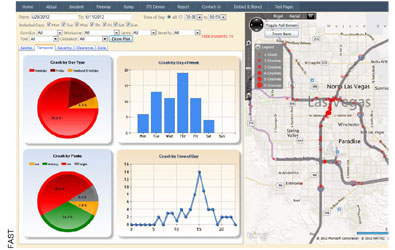
Operators also identify and document traffic crashes they observe within the network as part of their normal incident management and response duties. Software developers on staff have developed easy-to-use and view safety dashboards of crash data, such as the one shown in Figure 20. Both summary statistics and a map of frequency by location can be viewed. Drop-down menus are used to focus on particular routes, types of crashes (such as work zone-related crashes or severe crashes), time periods, and/or response requirements.
Lessons Learned
A number of lessons learned were offered by FAST management personnel relative to the use of the system for work zone traffic management and performance measurement. These lessons are summarized below.
It is important to engage permanent ITS personnel early in the work zone planning process – Permanent ITS personnel need to be included early enough in work zone design and scheduling decisions to help determine how best to make use of existing ITS resources (both equipment and personnel). The work zone ITS deployment on the I-15 DB project involved some data sharing between the temporary system and FAST and some informal monitoring of the system by FAST operators. FAST staff think the effectiveness of the work zone ITS could have been enhanced significantly if it had been better integrated into the overall FAST operation, and that earlier involvement in work zone planning would have increased the probability of effective integration. As a result of this and other experiences, FAST management personnel are working with NDOT to become more involved in work zone ITS planning processes in the future so as to maximize the potential effectiveness of overall integration efforts as well as management and response strategies that would be possible. NDOT personnel have agreed that improved coordination with FAST would be beneficial on future work zone ITS deployments.
Work zone crash risk is highest during the first few days of a project, and so advance notification of changes in lane configurations or other temporary traffic control conditions is important – A permanent system such as FAST can be beneficial in getting the word out to travelers a few days in advance of such changes.
Lane shifts and other changes during a work zone project require timely re-calibration of detectors – This recalibration effort takes time and effort. Depending on how the contract is written, the contractor may be required to recalibrate not only the temporary sensors, but the sensors for the permanent system as well. It is important to check that resources have been allocated for this activity by the contractor.
It is important that a good electrical subcontractor with ITS device experience be included on a contractor’s team for any project that directly or indirectly interacts with ITS components – A lack of such experience on the contractor team can cause problems in getting system components installed and operating properly. It is important to request and assess contractor qualifications when reviewing project bids.
A better understanding is needed of how traffic-related messages on CMS and other devices affect driving decisions and behavior – The posting of a particular message can lead to significant diversion in some cases, but not in others. Research is needed, possibly at a national level, to better understand what roadway network and message attributes affect driver diversion decisions, and by how much. This would enable operators of permanent and temporary ITS to better tailor messages to the level of response desired.
Establishing and maintaining a good relationship with the media can help maximize the effectiveness of ITS – FAST experiences have shown that being proactive in getting information out to the media can pay dividends by helping to influence the messages that the media is putting forth.
It is valuable to have a good programmer on staff – A good programmer who understands how a particular ITS deployment has been designed and is managed can be extremely useful in designing user interfaces, data archival methods, and other analytical elements that operators and managers can then use effectively as part of their duties.
It is important to organize the incoming data from an ITS deployment in a logical way – Centers such as FAST generate tremendous amounts of data that can overwhelm the system and be of little value for analysis purposes. Mechanisms tailored to organizing the data in a way that allows for easy archiving and subsequent retrieval by location, time, etc. can be very valuable for both real-time work zone traffic management and for performance measurement activities. For example, it makes it easier to see and track trends over time, can aid decision making for lane closure requests, and can improve incident management efforts if operators can quickly assess how previous incidents in the same location and time of day affected travel patterns.
< Previous | Next >