Best Practices for Road Weather Management
Texas DOT High Water Detection System
High water detection systems (HDWS) are installed in stream beds at road and stream crossing locations with a potential or a history of flooding. The Texas Department of Transportation (TxDOT) has installed twenty such of these systems throughout the San Antonio area. An additional six are being installed in 2012. The San Antonio district has installed one system in the metro area, while the other units (including the six new units under construction) have been installed in the rural areas surrounding San Antonio, primarily at locations in the Texas Hill Country, which are subject to flash flooding due to the region’s topography. The first units were installed in 2005. The unit cost is typically $75,000.
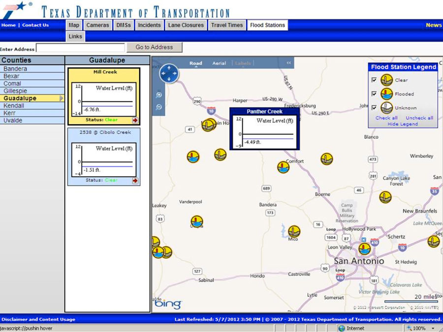
Figure TX-1. Public Internet display of TxDOT-San Antonio high water detection systems.
System Components: The HWDS consists of the following elements:
- A stand pipe installed in the stream bed or measuring device attached to the crossing structure (bridge or culvert)
- Wire line or wireless communications from the measuring system to the local computer
- Wire line or wireless communications from the local computer to advanced warning signs
- Advanced warning signs, with flashers
- Central/Master software
- Cellular communications from the systems to a contracted operations center
- Internet-based communications from the contracted operations center to TxDOT’s network
System Operations: The level of water in the stream bed is measured by a stand pipe or a device mounted on the bridge or culvert crossing the stream. The water level is transmitted to a local computer mounted in a cabinet near the stream crossing (which is installed above the flood elevation). The local computer activates flashers on warning signs on the approaches to the stream crossing. The local computer also transmits system status and water elevation to the central software application at the contracted operations center. Local topography for each location determined during installation and the water elevation data provided by the local computer are used to create a public Internet display, as seen in Figure TX-1, which provides a graphic display of the conditions. The conditions are noted as flooded or not flooded, or no data available. A secure web site is available for TxDOT staff that provides detailed information regarding each system’s status, operational history and historic water levels.
Transportation Outcome(s): The San Antonio HWDS allow emergency responders, TransGuide Operators, TxDOT public information, the public and the media to monitor the conditions at the locations during a rain event. The flasher equipped advanced warning signs provide a notification to drivers that a road is flooded ahead. It allows maintenance crews to monitor the HWDS from their offices and dispatch crews to set barricades when flood conditions are imminent.
Implementation Issues: The majority of TxDOT’s locations are in remote areas. Establishing communications to those sites required working with cellular providers, and identifying the best location for the equipment cabinet based on the topography and wireless coverage availability. All current TxDOT HWDS were installed by one manufacturer. The six new units are being installed by a second manufacturer. To ensure the data from the HWDS from any manufacturer is available, TxDOT required that the manufacturers provide the data using a specific protocol found in TxDOT’s Environmental Sensor Station documentation. That protocol is compliant with the National Transportation Communications for ITS Protocol (NTCIP).
Contact(s):
- Brian G. Fariello, P.E., Traffic Management Engineer, TxDOT-TransGuide, 210-731-5247.
Reference(s):
Keywords: TxDOT, TransGuide, Storm, Water, Detection, Pump, Flood, Stream.
previous | next