Best Practices for Road Weather Management
New Mexico DOT Dust Control System
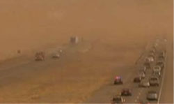
Dust storms occur quite frequently in New Mexico. They are the result of when powerful winds pick up large quantities of very dry (and thus, easy to particulate) exposed surface soil and obscures visibility as depicted in Figure NM -1.
The low visibility detection system installed along Interstate 10 (I-10) at the southwest corner of New Mexico in what is called the La Playa Region (ancient dry lake bed). This stretch of I-10 is routinely closed due to dust storms, some of which have been fatal in the past. The system was installed at the end of 2011 as part of a technology transfer research project with New Mexico State University acting as the principal investigator.
The research project is ongoing and currently in the evaluation phase (expected to continue for two years). The purpose of the system is to work in a coordinated fashion with other ITS deployments along I-10 (Dynamic Message Signs [DMS], Closed Caption Televisions [CCTV], and Highway Advisory Radio [HAR]) to assist in incident management (including network surveillance and information dissemination) when dust storms occur. The scope of the installation is limited to the immediate vicinity of the La Playa Region at mile points 10 and 11 of I-10. The cost of two installations was approximately $200,000. The installations began in October and were completed in November of 2011.
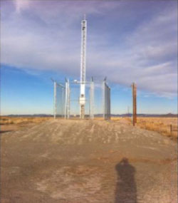
System Components: The NMDOT La Playa RWIS system consists of the following specific equipment:
- Ultrasonic Wind Sensor
- Present Weather / Visibility Detector
- Air Temperature and Humidity Sensor
- Solar Radiation Shield
- Barometric Pressure Sensor
- Remote Processing Unit (Battery Backup)
- 30-foot collapsible (folding) tower
- Video Monitoring System
- Wireless modems
System Operations: System relies on web-interface for access. Collected data includes:
- Air Temperature
- Dew Point Temperature
- Wind speed
- Max Wind speed
- Precipitation with rolling averages for 1, 3, 6, and 24 hours
- Relative humidity
- Visibility
Data is managed, stored and accessed via Vaisala Inc. Navigator System.
Power service is via standard secondary power (no solar).
The System can provide notifications to various stakeholders (NMDOT Maintenance and Dispatch Staff, Law Enforcement) when parameter values for wind speed or visibility are exceeded. These notifications are used to place responders into high alert on the potential for dust storms. Should one occur, this system will be used in conjunction with traveler advisories via DMSs, HARs and 511 / Website and network surveillance systems at pre-determined closure points.
Transportation Outcome(s): The La Playa I-10 RWIS system is still in the evaluation phase of the research project. Benefit and Cost criteria has been established and will be collected over the next two years to determine if the system is suitable and feasible for a wider deployment.
Implementation Issues: Bringing power to each of the remote installations has been the most substantive element of concern.
Contact(s):
- Ruinian Jiang, Principal Investigator and Evaluator for NMSU, 575-646-1506.
- Scott McClure, P.E., Chief of NMDOT Research Bureau, 505-798-6739.
- Charles Remkes, P.E., Manager NMDOT ITS Operations, 505-222-6554.
Reference(s):
Keywords: Dust Storms Low Visibility Warning System.
previous | next