Best Practices for Road Weather Management
Alabama DOT Low Visibility Warning System
In March 1995 a fog-related crash involving 193 vehicles occurred on the seven-mile (11.3 kilometer) Bay Bridge on Interstate 10. This crash prompted the Alabama Department of Transportation (DOT) to deploy a low visibility warning system. The warning system was integrated with a tunnel management system near Mobile, Alabama.
System Components: Six sensors with forward-scatter technology are used to measure visibility distance. The visibility sensors are installed at roughly one-mile (1.6 kilometer) intervals along the bridge. Traffic flow is monitored with a Closed Circuit Television (CCTV) surveillance system. Video from 25 CCTV cameras is displayed on monitors in the Traffic Management Center (TMC). Field sensor data is transmitted to a central computer in the TMC via a fiber optic cable communication system. The computer controls 24 Variable Speed Limit (VSL) signs and five Dynamic Message Signs (DMS), which are used to display advisories or regulations to motorists.
In 2008, a system upgrade was performed to the fog system. These upgrades included updating devices, improving the method of communication with these devices by going from a point-to-point system to Ethernet, and the addition of Radar Vehicle Detection (RVD) devices every one-third of a mile along the Bayway.
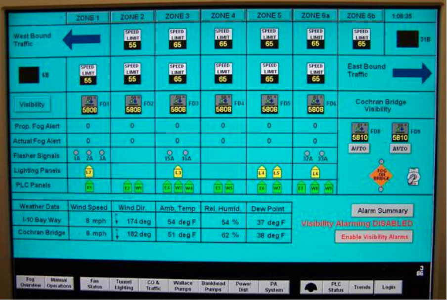
Figure AL-1. Screen Shot of Low Visibility Warning System.
System Operations: At least two Automated Transportation System (ATS) Operators staff the TMC twenty-four hours a day. When fog is observed via CCTV, ATS Operators consult the central computer, which displays visibility sensor measurements by zone. The warning system is divided into six zones which can operate independently. Depending on visibility conditions in each zone, operators may display messages on DMS and alter speed limits with VSL signs (as shown in the Table AL-1, Visibility Warning System Strategies).
When the speed limit is reduced, notices are automatically faxed to the DOT Division Office, the Highway Patrol and local law enforcement agencies in Mobile and neighboring jurisdictions (i.e., Daphne and Spanish Ford). If necessary, ATS Operators request that the Highway Patrol utilize vehicle guidance to further reduce traffic speeds. During vehicle guidance operations a patrol vehicle with flashing lights leads traffic across the bridge at a safe speed.
Transportation Outcome(s): Although labor-intensive, the warning system has improved safety by reducing average speed and minimizing crash risk in low visibility conditions.
Implementation Issues: The original system design included a vehicle detection subsystem, backscatter visibility sensors, and automated activation of signs. Bridge deck construction precluded the installation of inductive loop detectors and vibration prevented the use of microwave vehicle detectors. Thus, the vehicle detection subsystem had to be eliminated. Visibility sensors with backscatter technology were deployed along the bridge in the fall of 1999. However, problems with accuracy and reliability caused the DOT to replace them with forward-scatter visibility sensors in 2000.
The original George C. Wallace tunnel control room was modified to incorporate monitoring and control functions for the warning system, which began operating in September 2000. By 2004, control of the warning system was transferred to the new Traffic Management Center.
Contact(s):
- David M. Johnson, Alabama DOT, ATS Center Manager, 251-432-4069
- Daniel Driskell, Alabama DOT, Acting Traffic Engineer, 251-470-8231
- Lee Reach, Alabama DOT, Division Maintenance Engineer, 251-470-8230
Reference(s):
- Schreiner, C., “State of the Practice and Review of the Literature: Survey of Fog Countermeasures Planned or in Use by Other States,” Virginia Tech Research Council, October 2000.
- U.S. DOT, “Mobile, Alabama Fog Detection System,” 2001 Intelligent Transportation Systems (ITS) Projects Book, FHWA, ITS Joint Program Office.
Keywords: fog, visibility, low visibility warning system, tunnel management system, speed management, traffic management, law enforcement, traveler information, advisory strategy, traffic control, control strategy, bridge, lighting, high-profile vehicles, motorist warning system, closed circuit television (CCTV), dynamic message sign (DMS), institutional issues, speed, safetyAlaska DOT&PF Temperature Data Probe Program.
previous | next