FHWA Freight and Land Use Handbook
1.0 Background on Freight and Land Use
1.1 Purpose and Content
The first step towards a more comprehensive inclusion of freight in the planning process is to ensure a common understanding of the stakeholders, roles and responsibilities, and trends involved in the process. Though public-sector agencies often have a firm grasp of the transportation planning and programming process, they do not always understand the private-sector decision-making process, or the land use and transportation needs of freight. Private-sector companies, though knowledgeable of their own needs and business priorities, often lack a full understanding of the public planning and programming process, or the ways that they can effectively be included in this process. The purpose of this section is to help practitioners to better understand the key concepts in land use and freight transportation. This section will be divided into four sections:
- Why Freight Should Be Considered in the Transportation and Land Use Planning Processes? summarizes the benefits of freight-generating businesses, as well as some of the key demographic, financial, economic, environmental, public policy, and industry changes that signify a need to include freight in the public planning process.
- Transportation and Land Use Planning Processes discusses the key steps and products of the transportation and land use planning processes, as well as the linkages between them.
- Public-and Private-Sector Stakeholders, Roles, and Needs discusses the types of public- and private-sector stakeholders that are involved with transportation and land use planning, as well as a discussion of some of the key freight issues that drive the decisions of each group.
- Freight and Land Use Trends and Issues discusses some of the key trends and challenges that will impact freight and land use decisions in the next 10 to 20 years.
1.2 Why Should Freight be Considered in the Transportation and Land Use Planning Process?
There are several compelling reasons to integrate freight into the land use and transportation planning discussion. For one, freight generating land uses can potentially bring great benefits to a region, by providing jobs, tax dollars, and proximity of goods to growing populations and businesses. Another, freight volumes, and their attendant impacts, are anticipated to grow significantly in the future, growing by over 60 percent (nationally) over the next 25 years, as will be discussed later in this section. Planning for their inclusion now will enable them to fit seamlessly into the community fabric, allowing them to provide benefits to their region while minimizing adverse impacts to local residents and the environment.
What are the Benefits of Freight Generating Land Uses?
Freight generating land uses, such as agriculture, natural resources and mining, construction, warehousing, manufacturing, logistics, and port and harbor operations, can bring tremendous positive benefits to a region. Understanding the positive benefits can help justify the retention of industrial land uses in growing urban areas, or of the need to include private-sector stakeholders in the public planning process. Some of the benefits of freight generating land uses include:
Employment
Freight generating industries can provide direct employment (jobs working directly for the business) as well as indirect employment driven by the economic activity of the jobs. For example, in an economic impact study performed in 2009 at the Port of Seattle, the port reported direct employment of 111,317 individuals, 62,128 induced jobs, and indirect statewide employment of over 200,000 people in Washington State. (The Port of Seattle 2009 Economic Impact Report.)
Tax Benefits
Freight generating land uses can bring tax benefits to a region. For example, a study conducted for the Southern California Association of Governments (SCAG) found that industries related to international trade and freight contributed $28.3 billion in state and local taxes to Southern California in 2005. (SCAG 2008 Regional Transportation Plan: Goods Movement Report.)
Contribution to State and Local Economic Output
Freight-related businesses can contribute billions of dollars to regional and statewide economies. For example, an economic analysis of the State of Kansas found that goods dependent industries led by agriculture, meat processing, and manufacturing, still accounted for almost 43 percent (This is larger than the national share (36 percent of overall output, or about $5.1 trillion); nonetheless, these industries remain critical to many state and local economies.) (or $40 billion) of state economic output in 2006. (Kansas Department of Transportation, Statewide Freight Plan, 2009.)
Assessing and Addressing Freight’s Environmental Impacts – USEPA SmartWay Program
The SmartWay Program is a public/private collaboration between the United States Environmental Protection Agency (USEPA) and the freight industry, which aims to assess and limit freight-related emissions and energy consumption. The program helps carriers identify opportunities to improve efficiency reduce energy costs, and demonstrate their efficiency to potential customers. The program helps shippers and logistics companies find efficient carriers, assess mode choice options, and reduce the carbon footprint of the transportation component of their supply chains.
Other Benefits
Other benefits are harder to measure, but nevertheless important to mention. For example, the presence of freight uses within heavily populated urban areas can offer closer proximity to goods and services for local businesses and citizens. In addition, freight movement is becoming cleaner and safer every day – with programs like the United States Environmental Protection Agency (USEPA) SmartWay Transport program working to increase the environmental efficiency of freight transportation on a national level. Potential benefits from freight will be most easily realized if freight generating land uses are developed in a manner that is consistent with regional land use and transportation goals. One way to accomplish this is to include freight stakeholders in the public planning process.
What are the Disbenefits of Freight Generating Land Uses?
Clearly, freight land uses can offer substantial economic, employment, fiscal, and other benefits to a region. Nonetheless, there are negative impacts associated with freight operations, particularly when they are concentrated within a small area. These disbenefits, which are discussed in greater detail in Section 3.0, include:
Air Quality Impacts
Most freight vehicles are powered by diesel fuel, as are many pieces of support equipment such as yard hostlers and cargo cranes. The combustion of diesel fuel for goods movement emits particulate matter, oxides of nitrogen, and sulfur dioxide, all of which contribute to air quality problems, especially in urban areas and around large freight generators. New regulations for several types of freight vehicles will reduce freight diesel emissions significantly, but this could take time since most freight vehicles have long-service lives.
Greenhouse Gas Emissions
Freight land uses also can be a significant source of greenhouse gas (GHG) emissions. GHG are heat trapping gases that accumulate in the earth’s atmosphere, thereby contributing to the “greenhouse effect” and global warming. Carbon dioxide (CO2) is the primary GHG produced by the transport sector. Although 60 percent of transportation-related GHG comes from passenger vehicles, much of the remainder is related to freight.
Environmental Justice
Environmental justice refers to the geographically equitable distribution of the benefits and burdens of government policies, programs, and investments, and to ensure the full and fair participation by all potentially affected communities in the transportation decision-making process. Many freight facilities are located in communities which have a large number of minority or lower-income residents, and which often receive significant environmental impacts from those facilities. Expanding freight operations or infrastructure in these communities requires taking strategies to reduce or mitigate impacts into consideration. (“Envision Freight: A Roadmap to Freight Compatibility,” Transportation Research Board, 2010.) What driving forces necessitate the integration of freight into the planning process?
Changes Indicating the Importance of Planning for Freight
There are several other demographic changes underway that will change the land use consumption needs of freight generating businesses in coming years. Understanding these key driving forces helps to illustrate the necessity of incorporating freight into the public planning process. Some key changes include:
Freight Volumes are Growing Nationally
Though freight volumes, nationally, have dipped in the 2005-2009 years (corresponding with a national recession), economic projections show sustained growth in the 2010-2035 timeframe (as shown in Figure 1.1 below). This growth means that there will be additional capacity demands on the highway, rail, air cargo, and marine systems. This increased demand will have to compete with growing passenger vehicle miles traveled (VMT) on the same transportation infrastructure. In addition, there will likely be the need for expanded freight land uses – in particular those closely tied to transportation such as rail yards and distribution centers.
Figure 1.1 National Multimodal Freight Tonnage, 2005-2035
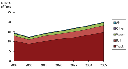
Source: IHS-Global Insight, Inc., 2007 TRANSEARCH data and economic projections.
Population Trends
As of 2007, 81 percent of the U.S. population lived in urban areas. The rate of urbanization is anticipated to grow steadily – in fact urban areas are expected to grow by an average annual rate of 1.1 percent through 2025, compared to -0.65 percent in rural areas. (United Nations Population Division, World Urbanization Prospects: The 2007 Revision, February 2008.) In terms of freight, larger urban populations will have two chief consequences: 1) Freight traffic will become more and more concentrated in cities, as freight movement will naturally increase in order to provide growing populations and business centers with the goods and services that they need to thrive; and 2) There will be additional demand for the facilities – such as ports, distribution centers, and intermodal rail yards – to serve that traffic. This growing need for land will have to compete with other regional land uses, including residential, commercial, public use, and open space.
The aging of the population also may impact these trends. There are essentially two ways through which the nation’s economy can grow and provide a rising standard of living: by adding workers, or by improving productivity. Given a generally aging population and declining birth rates, it may be difficult to expand output through adding workers. However, investing in freight transportation can improve long-term productivity in the economy by reducing the cost of moving goods. Therefore, investment in freight infrastructure – including public outlays for port improvements or intermodal hubs – may increasingly be seen as an effective tool for state and regional economic development.
Climate Change, Sustainability, and Livability
Growing concern among policy-makers and the general public about climate change, livability, and sustainability also may impact land development as it relates to freight. For instance, community livability concerns and “Not In My Back Yard” (NIMBY) sentiments may hamper the ability of freight generating businesses and other entities (such as ports) to locate or expand in certain places. Industrial lands, ports, and rail yards in dense urban areas already are under significant pressure to be redeveloped into “higher value” commercial or residential uses. This is partially the result of a trend towards denser, urban living arrangements for both economic development and sustainability reasons.
Financial Challenges in Addressing Infrastructure Needs
This growth in freight flows will coincide with increasing challenges faced by Federal, state, and local governments in terms of funding infrastructure needs. As shown in Figure 1.2, the real costs of building streets and highways have been growing consistently over the last few decades, with a pronounced spike in the last decade. Meanwhile, revenues available for transportation projects have remained flat or even fallen when adjusted for inflation. Demand for construction materials in developing nations such as China will likely contribute to construction-cost inflation in the years ahead even as the growth in freight tonnage adds additional traffic to the system.
Figure 1.2 Producer Price Index for Highway and Street Construction, 1987-2009
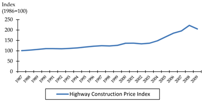
Source: Bureau of Labor Statistics.
1.3 Land Use and Transportation Planning Processes and Linkages
What is Land Use Planning?
Land use planning can generally be described as a branch of public policy that seeks to regulate the use of land in an ethical and efficient manner. Land use planning is important to the public and private sectors because the process of land use planning determines how land will be used in the future, which can create opportunities and issues for businesses and citizens. Land use planning practice varies by state, region, and municipality. This variation is the result of several factors, including differences in the level of authority states grant to local governments and differing policy priorities among towns, cities, and regions.
Who Does Land Use Planning?
Land use controls, such as zoning, are typically the responsibility of local governments, such as municipalities or counties. Therefore, most land use planning is conducted by city or county planning departments, and/or by regional bodies such as a council of governments. The level of authority exercised by these entities will vary depending on states’ enabling legislation. Florida, for example, gives county governments the authority to develop their own land use and growth management plans. By contrast, counties in Texas have no authority over land use decisions.
Some state governments also participate in the land use planning process, for example by reviewing local plans to ensure their compatibility with statewide goals or plans of neighboring municipalities, sometimes through a statewide planning agency or commission. Delaware, New Jersey, Florida, Oregon, and Hawaii have all adopted such a statewide land use planning approach.
What are the Key Steps and Main Products of Land Use Planning?
Land use planning is comprised of several processes that guide how the land within a municipality will be used. The major components of the land use process include several different discrete products, including:
- Comprehensive/land use plan;
- Zoning code/land development regulations; and
- Land use permitting issues and process.
The comprehensive plan (also known as the master plan or general plan) serves as the overarching blueprint for future growth. It supplies a framework that the zoning code helps to implement through the use of development guidelines and regulations. The vision of the comprehensive plan and zoning code may be facilitated through permitting processes that offer specific approval to projects that fit within the framework of the plan and code. Each of these components are described in the following sections.
Figure 1.3 A Sample Land Use Plan Showing Proposed Land Use Designations and Locations
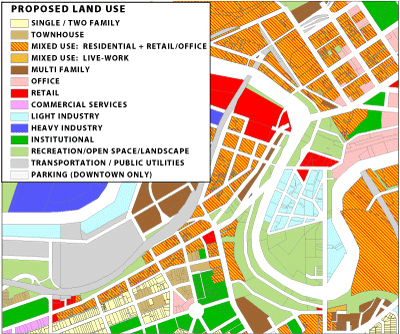
Source: “Connecting Cleveland: 2020 Citywide Plan,” City Planning Commission, City of Cleveland (Ohio).
The Comprehensive Plan
The comprehensive plan is the local government’s development guidebook. It typically includes a general statement of goals and objectives, policies, and standards upon which future land use decisions are to be made. (Nolon, John and Salkin, Patricia, Land Use in a Nutshell.) It will also include existing and proposed land uses, categorized into groups such as residential, commercial, and industrial uses. (Note that there are no standard requirements for comprehensive plan content or update procedures, due to the multiplicity of state laws and requirements. However, professional associations such as the American Planning Association do identify and develop best practices guidelines.) Throughout the plan development process, a strong public participation component is urged to ensure that citizens and businesses alike have a say in the plan content. Adoption of the comprehensive plan is a legislative act requiring approval by the local government or legislative body to become effective.
The land use information and guidelines in a comprehensive plan may or may not be legally binding, depending on state law. In some states, the comprehensive plan is generally more of a guide from which to create zoning and other land use regulations, or to document community wishes for future development. As a result, there can be inconsistencies between the comprehensive plan and other regulations such as zoning codes or land development regulations. At the other end of the spectrum, some states (for example Florida and Oregon) have granted comprehensive plans the force of law, and require local zoning enforcement to be consistent with plan objectives. (Source.)
The Zoning Code and Land Development Regulations
Zoning is a widely used method by local governments to control the physical development of land. The zoning code is a separate document from the comprehensive plan, and may or may not be consistent with the plan. The zoning code creates “zones” of land designated for residential, commercial, industrial, governmental, open space, or other land uses.
The zoning code is normally included within the local land development regulations (LDR). The LDRs govern all aspects of development – such as lot subdivision, wetlands protection, storm water management, signs, and parking – in addition to zoning. Some cities (for example Houston, Texas) do not have zoning. Instead, they rely on subdivision regulations (rules that set standards for the design of residential subdivisions, such as access road requirements and open space provisions) or land use ordinances to guide their development.
There are four basic types of zoning that cities may employ, as summarized below and shown in Figure 1.4:
- Traditional or “Euclidean” zoning (Euclidean zoning is named after the 1926 U.S. Supreme Court case which established the constitutionality of zoning (Village of Euclid, Ohio v. Ambler Realty Co.)) segregates land uses into specified geographic districts and provides dimensional standards and other rules to regulate development within each zone. This is the most widespread form of zoning in the U.S.
- Form-Based zoning seeks to regulate the form of different land uses/developments rather than their type. This type of zoning is often used when a municipality wishes to preserve or promote a certain development pattern, for instance in a downtown or historic area.
- Performance zoning regulates the acceptable intensity of different land uses, for instance by specifying the number of residential units per acre. In theory this can provide for more flexibility for both the city and developer by reducing land use conflicts.
- Incentive zoning is the practice of granting developers extra amenities they want (often by allowing higher density developments) in exchange for the provision of urban amenities such as green space, infrastructure enhancements, affordable housing, or public spaces.
Figure 1.4 Types of Zoning Codes
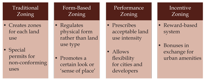
Source: Cambridge Systematics, Inc., 2010.
Different types of zoning can be used in conjunction with each other. For instance, a city may create a form-based overlay district on top of a traditional zoning code to achieve specific development outcomes. In addition, it is possible to make amendments to zoning ordinances, or to request a zoning variance or conditional use permit. For example, a developer may apply to change the zoned land use of a parcel from industrial to residential use, or may argue that a school should be allowed as a “conditional use” in a residential area.
Land Use Permitting Issues and Process
The permitting process is the final stage of land use planning implementation. There are a number of issues that may arise during the permitting process that will require review. For this reason, the permitting process can take years to complete. This is especially true for projects that may have significant environmental consequences, or those that encroach upon historic landmarks or scenic routes. Projects of this type will likely need to be reviewed by several different agencies (such as the planning committee, the landmarks board, and the Department of Conservation). The permitting stage also is where municipalities may be able to hold developers or landowners to other requirements – for example mandating minimum or maximum parking requirements in order for the project to gain approval. Since the specific requirements can vary on a city by city basis, it is important for a developer or private-sector business to have a clear idea of what is allowed, what is prohibited, and what the land use process is for variances within the municipality of interest.
What is Transportation Planning?
The Federal Highway Administration (FHWA) defines transportation planning is: “A continuing, comprehensive, and cooperative process to encourage and promote the development of a multimodal transportation system to ensure safe and efficient movement of people and goods while balancing environmental and community needs.” (Source.) Transportation planning is important to the public and private sectors because it creates and maintains the safe, efficient transportation infrastructure that private citizens and businesses rely on for their day-to-day mobility.
Freight considerations within transportation planning practice include:
- Developing an understanding of the freight volume, value, key commodities, and mode splits in a region;
- Establishing policies and programs to integrate freight within the overall transportation planning process and account for freight needs in project selection and prioritization; and
- Linking freight mobility to other community goals such as economic development and job growth.
Who is Responsible for Transportation Planning?
Transportation planning is carried out by several different government agencies:
- State DOTs are responsible for the overall statewide planning and implementation of transportation investments.
- Metropolitan Planning Organizations (MPO) are associations of regional decision-makers which every urbanized area above a certain population threshold must have by Federal law – are charged with planning and prioritizing transportation projects within their region.
- County and local governments design, build, and maintain local roads and streets that do not fall under the purview of the state DOT. Many larger cities have their own DOTs.
- Transit operators often conduct system planning studies, as well as participate in local transportation planning in conjunction with an MPO or other local agencies.
- Other entities – such as regional authorities, port authorities, or railroads – may be responsible for operating specific pieces of the transportation system, such as a toll road network.
The specific roles and responsibilities of all these players are described in more detail in Section 2.3.
What are the Key Steps and Main Products of Transportation Planning?
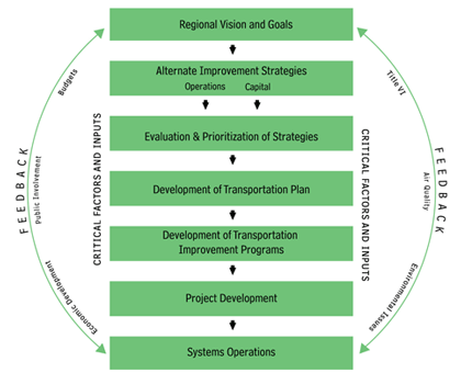
Figure 1.5 below highlights the transportation planning process at a high level. The regional vision and goals are incorporated into new strategies, which are then formalized in the Long-Range Plan (LRP) sometimes referred to as the Metropolitan Transportation Plan (MTP) or the Long-Range Transportation Plan (LRTP) and prioritized within the Transportation Improvement Program (TIP) or Statewide Transportation Improvement Program (STIP). These are discussed separately in more detail later. Projects are then implemented and the performance of the system is monitored to provide ongoing feedback, which will then inform the ongoing development of the transportation system. (More detail on the process, products, and issues associated with transportation planning may be found at 23 CFR 450, Subparts A, B, and C.)
Public participation is a key consideration throughout this process. In fact, DOTs and MPOs are required to develop and implement a documented public involvement plan that provides for meaningful participation and input from all stakeholders, including freight shippers and public review/comment at important decision points. (3 CFR 450.210, 23 CFR 450.316.)
FHWA provides numerous reference handbooks for transportation planning in general as well as for freight planning specifically.
Figure 1.5 The Transportation Planning Process
Source: DOT/FHWA.
This planning process revolves around several key factors that must be considered when evaluating transportation projects, services, and policy options. These planning factors are shown in Figure 1.6, along with their relationship to freight and/or land use.
Figure 1.6 Transportation Planning Factors and Relationship to Freight or Land Use
Source: Cambridge Systematics, Inc., with content from 23 CFR 450.206, 23 CFR 450.306, 2010.
Unified Planning Work Program (UPWP)
This document includes all of the studies and tasks that will be performed by the MPO. It covers a one-to two-year period and contains planning tasks, Federally funded studies, and state/local planning activities conducted regardless of how they are funded, funding sources for each project, a schedule of activities, and the agency responsible for each task/study. Note that the MPO does not necessarily conduct all of the studies contained in the UPWP; sometimes other local agencies (such as a transit provider) conduct the study, and may use their own sources of funding to conduct part or all of the study.
Metropolitan Transportation Plan (MTP)
In metropolitan areas, the MTP is the regional transportation system investment plan. According to Federal regulations, this will include both long-range and short-range strategies/actions that lead to the development of an integrated intermodal transportation system that facilitates the efficient movement of people and goods. It is important to note that the MTP must be fiscally constrained, in the sense that the projects contained therein must have a realistic chance of being funded with expected revenue streams; in other words, the plan cannot just be a ‘wish list.’ The MTP has a time horizon of at least 20 years, and is updated every 4 to 5 years depending on the region’s air quality attainment status. The plan addresses:
- Policies, strategies, and projects for the future;
- A systems-level approach by considering roadways, transit, nonmotorized transportation, and intermodal connections;
- Projected demand for transportation services over 20 years;
- Regional land use, development, housing, and employment goals and plans;
- Cost estimates and reasonably available financial sources for operation, maintenance, and capital investments; and
- Ways to preserve existing roads and facilities and make efficient use of the existing system. (“The Transportation Planning Process: Key Issues.” Publication of the Transportation Planning Capacity Building Program, FHWA, and FTA. Updated September 2007.)
Transportation Improvement Program (TIP)
The TIP is the four-year transportation program for the urbanized area. This is the region’s way of allocating limited transportation resources among various needs of the MPO region. The TIP implements the region’s transportation plan. Often, MPOs will use performance-based criteria to select projects that support plan goals and community priorities. This list of projects is updated at least every four years, is approved by the MPO and governor, and is incorporated directly into the Statewide Transportation Improvement Program (STIP).
The Long-Range Statewide Transportation Plan (LRTP or LRSTP)
This is a state-level plan developed by the DOT, which varies from state to state in the level of detail. Some plans are policy plans which focus on statewide goals, while others are project-specific. Most of the statewide plans address similar topics as the MTP, but on a statewide scale. Namely:
- Policies and strategies, and/or future projects;
- Projected demand for transportation services over 20 or more years;
- Statewide and regional land use, development, housing, natural environmental resource and employment goals, and plans; and
- Ways to make more efficient use of the existing system.
While not required, cost estimates and reasonably available financial sources for operation, maintenance, and capital investments are encouraged.
Statewide Transportation Improvement Program (STIP)
The STIP is a consolidated list of transportation projects covering four years at the state level. The state prioritizes projects from rural, small urban, and urbanized areas of the state. TIPs from MPOs are incorporated directly without change into the STIP. The STIP is approved by the U.S. DOT (FHWA and FTA). STIP approval must be granted before projects can move from planning to implementation. (“The Transportation Planning Process: Key Issues.” Publication of the Transportation Planning Capacity Building Program, FHWA an FTA. Updated September 2007.)
Other Plans and Studies
There are many other types of studies or plans that may be interconnected with freight planning in a state or region. For instance, safety plans typically have commercial vehicle safety as one critical component. States and regions will sometimes create corridor plans to address congestion and mobility issues on specific pieces of infrastructure, many of which are key freight corridors. Many states and some larger metropolitan areas also develop stand alone freight plans to better articulate goods movement issues and connect them to the wider transportation planning and policy program.
Figure 1.7 The Transportation Land Use Cycle
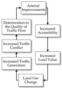
Source: Stover and Koepke, 2002.
Why is it Important to Link the Transportation and Land Use Planning Processes?
Transportation and land use planning processes in many regions are separate processes, and are completed by a range of stakeholders on different timelines. Nonetheless, the way in which land is developed will dictate, to a large extent, the transportation modes and volumes of traffic using our transportation infrastructure (as illustrated in Figure 1.7). For example, some types of land uses, including residential land use, will attract a small number of trucks at irregular intervals – i.e., the occasional delivery or service truck. Other land uses, including manufacturers, will rely on a steady stream of large trucks to deliver raw materials and remove manufactured product.
In addition, failure to consider land uses when doing freight planning (and vice versa), runs the risk of introducing conflicts between types of land uses, or competing passenger and freight uses for the transportation system. This conflict can, essentially, run counter to a region’s goals – decreasing safety, reducing mobility, and making the region an unattractive place for business attraction/retention. Indeed, industrial developers prefer to locate in communities with transportation and land use vision and a coordinated permitting process. (NCFRP 23 Preliminary Draft Report.)
As a result, it is important that land use and transportation planning decisions complement, not contradict, one another. Creating overlap and links between the transportation and land use processes is necessary to ensure that complementary land use and transportation decisions are made. Figure 1.8 shows the parallel land use and transportation planning processes, and key links between the two.
Figure 1.8 Relationships Between Transportation and Land Use Planning Processes
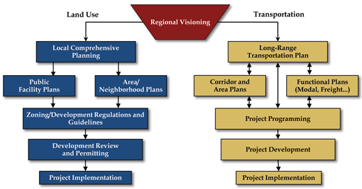
Source: Cambridge Systematics, Inc., 2010.
One key link between these processes involves the “Protect the Environment” planning factor (listed in Figure 1.6) and the requirement that state and regional transportation plans be consistent with state and local environmental goals, growth and development priorities, and economic development strategies. This planning factor provides for a particularly strong link between freight and land use planning since freight operations can contribute substantially to all of these goals.
Some methods already exist to strengthen the ties between transportation and land use planning. Federal law outlines land use considerations that need to be made when transportation stakeholders, elected officials, and the public make decisions regarding the maintenance, operations, and expansion of transportation systems. (Title 23, Code of Federal Regulations, Section 450.) For instance, it is required that transportation improvements be coordinated with planned growth and economic development patterns. This is critical to ensuring that local, regional, statewide, and national transportation systems are not built in a vacuum but with the needs of communities, the environment, and the economy in mind.
Other ways in which the transportation and land use planning cycles can be better coordinated include:
- Ensuring that transportation strategies are adopted into the comprehensive plan;
- Adopting transportation policies into the zoning ordinance as development standards;
- Transportation agency review of site plans for developments that require highway access or that have an impact on traffic operations;
- Outreach to the public on planning outcomes;
- Partnership efforts with local agencies;
- Transportation project selection criteria that is consistent with Comprehensive Plan goals; and
- Financial incentives for local action to support the regional vision.
In addition, public-sector transportation agencies can provide technical assistance to public-sector land planners and developers to guide successful integration of transportation facilities. Additional strategies by which to better integrate freight and transportation planning processes will be discussed in later stages of this handbook.
What are the Primary Functions of an MPO?
- Establish and manage a fair and impartial setting for effective regional decision-making in the metropolitan area.
- Use data and planning methods to generate and evaluate alternatives. Planning studies and evaluations are included in the UPWP.
- Develop a long range (20-year) transportation plan for the metropolitan area that fosters 1) mobility and access for people and goods, 2) efficient system performance and preservation, and 3) good quality of life.
- Develop a short-range (four-year) transportation improvements program (TIP) based on the long-range transportation plan.
- Involve the general public and other affected constituencies in the four essential functions listed above.
1.4 Public- and Private-Sector Stakeholders, Roles, and Needs
A variety of public- and private-sector stakeholders are involved in the transportation and land use planning process. This section will introduce some of the key participants in each process, at the local, regional, and state level.
Who are the Key Public-Sector Participants in Transportation and Land Use Planning?
There are several key participants in the land use planning process, including local decision-makers (members of local legislative bodies, planning boards, and zoning boards), professional planners, lawyers and judges, code enforcement officers, engineers, architects, other related boards, and members of the public. (Babcock, Richard. The Zoning Game: Municipal Practices and Policies.) However, those responsible for the process and implementing the laws and plans are public-sector employees. Primarily, this involves a variety of agencies that exist at the local, regional, and state level.
The transportation planning process is governed by a variety of agencies, including state DOT, MPO, local, and county governments. No single agency has control over the entire transportation system. For example, most county or city streets are designed, operated, maintained, and owned by counties or local governments. Transit systems are maintained by transit operators. MPOs are responsible for managing the planning process and stakeholder involvement in the process for surface transportation modes and facilitating intermodal connections in cooperation with their planning partners. Other agencies, such as regional authorities for airports, ports, toll roads, ferries, or major bridges or transit agencies may help to influence policy and planning of the transit and road system. The state DOT is responsible for statewide planning activities, as well as interstate highways and other state-owned roadways. The responsibilities and roles of each of these entities are explained on the following pages of this handbook. Much of the background information below is taken from FHWA’s and FTA’s “The Transportation Planning Process: Key Issues” briefing book. (“The Transportation Planning Process: Key Issues.” Publication of the Transportation Planning Capacity Building Program, FHWA, and FTA. Updated September 2007. )
The key local, regional, and state-level participants involved in transportation and land use planning are illustrated in Figure 1.9 below:
Figure 1.9 State, Regional, and Local Transportation and Land Use Planning Entities
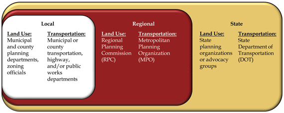
Source: Cambridge Systematics, Inc., 2011.
Local Legislative Bodies
Local governments, including counties, cities, townships, or other administrative entities may derive land use planning authority from state enabling legislation, home rule provisions, the state constitution, and/or municipal charter. In many cases, state statutes give local legislative bodies the authority to decide to keep or distribute planning powers, such as the land use process, to planning or zoning boards. Therefore, each local government may differ with regards to what board is responsible for what actions, and how boards/agencies interact with one another.
What are the Primary Planning Functions of a DOT?
- To develop and update a long-range transportation plan for the state;
- To develop a statewide transportation improvement program (STIP) based on the state’s long-range transportation plan. For metropolitan areas, the STIP incorporates the TIP developed by the MPO;
- To involve the general public and all of the other affected constituencies in the essential functions listed above; and
- Responsibility for the design, construction, operation, and maintenance of multimodal state facilities.
Metropolitan Planning Organizations (MPO)
An MPO is a transportation policy-making body made up of representatives from local government and transportation agencies. Federal regulations require the establishment of MPOs in urbanized areas with populations greater than 50,000. MPOs were created to ensure that existing and future expenditures for transportation projects and programs were based on a continuing, cooperative, and comprehensive planning process. Therefore, they have responsibility to bring together local jurisdictions and transportation authorities to make coordinated transportation decisions in the metropolitan area. In addition to MPOs that are established as standalone entities, MPOs can be found within Councils of Governments (COG) and other types of regional agencies. Some single county MPOs can also be found within county planning commissions or housed within city governments.
The MPO is responsible for the development of the metropolitan transportation plan (MTP). Both the governor and the MPO are required to approve the TIP. Generally, MPOs will not take the lead in implementing transportation projects, but will provide an overall coordination role in planning and programming funds for projects and operations. A state DOT, local entity or authority typically implements the projects.
There is no required structure for an MPO as a decision-making policy body. A typical MPO may be composed of a policy or executive board, a technical and citizen’s advisory committee, and a director and staff. Many MPOs in regions with considerable freight activities have freight subcommittees that include railroads, ports, airports, trucking organizations, state representatives and other stakeholders. MPO staff assists the MPO board by preparing documents, fostering interagency coordination, facilitating public input and feedback, and managing the planning process. The MPO staff also performs technical analysis such as freight studies, modeling, and scenario planning to inform the decision-making process.
State Planning Agencies
State-level involvement in the land use planning process varies by state. Several state governments, such as Delaware, Florida, Hawaii, and Oregon have become very involved in local land use planning processes, often requiring local governments to submit land use plans to state or regional agencies for review. A number of other states (such as New Jersey) have implemented state-level planning practices that have impacts on local land use.
States resource and regulatory agencies manage most regulatory and permitting activities, such as:
- Sewage facilities;
- Water supply facilities;
- Energy generation;
- Surface water quality;
- Air quality;
- Mining;
- Municipal, residential, and hazardous waste facilities; and
- Storm water management.
State Departments of Transportation (DOT)
State DOTs play three key transportation roles at the statewide level:
- Planning, or the process of establishing overall goals and priorities for transportation to shape policy and investment decisions and identifying projects that satisfy those goals;
- Project programming, which is the process of funding and prioritizing transportation investments; and
- Project implementation, or the construction, operation, and maintenance of multimodal transportation infrastructure.
State DOTs carry out these roles in all U.S. States, Puerto Rico, and the District of Columbia. State DOTs may work with airports, railroads, tolling authorities, ports, local agencies, and special districts that own, operate, or maintain different portions of the transportation network. (“The Transportation Planning Process: Key Issues.” Publication of the Transportation Planning Capacity Building Program, FHWA and FTA. Updated September 2007.) The state DOT is responsible the maintaining the state transportation system other than county and locally owned roads and for planning activities outside of metropolitan areas (outside of MPO boundaries) as well as interstate highways and other state-owned roadways.
State DOTs and MPOs work together closely. For instance, the DOT is typically part of the MPO policy board. A DOT will often involve the MPOs as a key stakeholder in any statewide transportation planning effort, in order to ensure that statewide transportation strategies are consistent with those of the MPOs. Outside of MPO boundaries, DOTs work with local and tribal governments, other public organizations, the private-sector, and the Federal land management agencies, bicycle and pedestrian advocates, the disabled and environmental agencies in the development of the long-range statewide transportation plan and the STIP. (“The Transportation Planning Process: Key Issues.” Publication of the Transportation Planning Capacity Building Program, FHWA and FTA. Updated September 2007.)
Public-Sector Freight Stakeholders – Key Issues
The public sector stakeholders summarized in the preceding section may feel conflicted about industrial land uses. On the one hand, they recognize that the businesses provide jobs, tax benefits, and economic activity to their region, as well as providing goods and services to the local population. On the other hand, the public sector is sometimes concerned that the externalities associated with the freight distribution system degrades amenities highly valued by nearby residents. Increasing truck and train traffic often generates opposition from local residents due to noise, exhaust and perceived safety and congestion impacts. Residents near ports, distribution centers, and other freight generating land uses are often impacted by light pollution from 24-hour operations and, in the case of new construction of freight facilities, may face degraded views or increased truck presence. For property owners these concerns go beyond simple quality of life issues – they directly impact property values and the desirability of certain neighborhoods or regions. Learning to manage these different benefits and drawbacks to industrial land uses, and communicating them to the public, can be very challenging to public-sector officials. Some of the key public-sector freight and land use issues are summarized in Table 1.1 below. They are grouped into three general categories, 1) Potential negative effects, 2) Potential positive effects, and 3) Other planning considerations.
| General Issue Category | Issue |
|---|---|
| Potential negative effects of freight and industrial land uses that public-sector agencies may have to address |
|
| Potential positive effects of freight and industrial land uses that may provide justification for their inclusion in the planning discussion |
|
| Other planning considerations that may influence the treatment of freight and industrial land uses in the planning and programming process |
|
Who are the Key Private-Sector Players that should be Involved and Knowledge about the Transportation and Land Use Planning Processes?
Private-sector freight stakeholders do not generally take a lead role in public planning decisions. Nonetheless, it is critical to engage them early and often in transportation and land use decision-making. In addition, the advent of Public Private Partnerships (PPP) and increasingly complex transportation projects means that they are being invited more frequently as partners into the planning process. This is especially the case when considering freight generating land uses, since freight uses are generally owned and controlled by the private sector. Collaborative planning between the public and private sector can result in greater understanding, better design, and more effective integration of freight into the land use and transportation planning process.
Figure 1.10 Private-Sector Freight Stakeholder Types
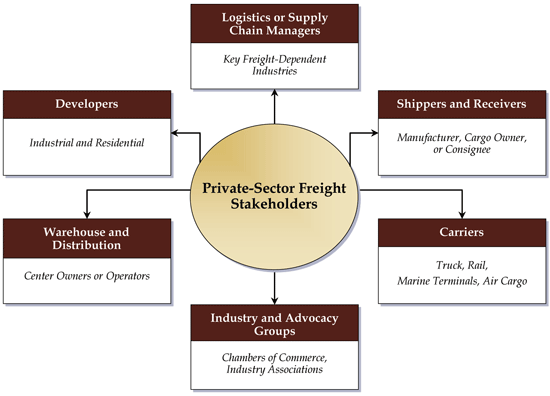
Source: Cambridge Systematics, Inc., 2010.
Logistics or Supply Chain Managers from Key Industries
Companies’ supply chain managers are responsible for maximizing the efficiency of a company’s supply chain, including monitoring the quality, cost, and quantity of goods movement and storage activities. As such they are tuned in to the freight and land use needs of their business or industry. Since these needs will vary by industry, planners should analyze the economic makeup of their community, identify the companies involved in key freight-dependent local businesses, and then consult with the supply chain and logistics managers of those firms to gain a better understanding of their needs and concerns.
Shippers (Beneficial Cargo Owners and Consignees)
Shippers are the companies or individuals who own or consign for the goods being moved over the transportation system. An example would be a manufacturing company which must ship its finished product, either to an end user or to a warehouse for further distribution to markets. Some shippers take control for planning and execution of the logistics and freight movement responsibilities for their goods, while others may give responsibility to a Third-Party Logistics providers (3PL). Therefore, though shippers are very important private-sector stakeholders, they sometimes are less knowledgeable about system performance issues than the carriers or 3PLs.
Carriers with Yards or Terminals
Truck, ocean, air, and rail freight carriers operate yards or terminals where loads are assembled and equipment such as truck tractors, trailers, containers, and railcars are positioned to meet the business needs of the carrier. Railroads operate both classification yards (where loaded railcars are divided and reassembled into different trains according to their destinations) and intermodal yards (which serve as the interface between railroads and trucks). Both types require considerable acreage. Rail yards frequently have miles of receiving, forwarding, and classification tracks; intermodal yards also require truck parking and trailer storage facilities. Trucking firms use terminals to store equipment and reposition fleets to meet changing demand conditions. In communities with water ports, private marine terminal operators often handle the day-to-day operations of terminals. Airports also have cargo terminals that may be operated by large carriers such as FedEx.
Industry Associations and Advocacy Groups
Advocacy and professional organizations that represent freight-dependent industries can range from chambers of commerce (which typically represent the entire local business community) to advocacy groups focused on a particular industry (such as a farm bureau or business association) or transportation mode (such as a state trucking association). Association members often range from small “Mom and Pop” businesses to international corporations which have a presence in a local area or an interest in an aspect of local industry or infrastructure. These organizations typically are well aware of the needs of their members and often collect data from them to inform their advocacy efforts. Planning agencies may already have contacts at local chambers of commerce, if they are consulted on other (not necessarily freight-related) matters. These contacts can be leveraged to find other important stakeholders.
Warehouse and Distribution Center Operators and Third-Party Logistics Firms
Warehouses and distribution centers are the locations where goods from multiple suppliers are consolidated or stored for eventual delivery to customers or retail outlets. For example, a warehouse can be used as an intermediate storage point between a manufacturer and its suppliers, or between the manufacturer and its industrial customers. Distribution centers also often provide services to shippers such as multimodal transportation, cargo tracking, customs clearance, and packing/labeling. (Lu, Chin-Shan and Yang, Ching-Chiao. ‘Evaluating Key Logistics Capabilities for International Distribution Center Operators in Taiwan.’ Transportation Journal, September 22, 2006.) Firms that provide these types of services are known as Third-Party Logistics providers (3PL); they specialize in integrating all or part of their client companies’ supply chains into a single tailored solution that can be scaled up or down according to market conditions. Warehouse operators and 3PLs therefore understand freight issues such as bottlenecks, street geometrics, and land supply which may be of value to land use and transportation planners.
Industrial and Commercial Site Developers
Developers understand the economic and logistics factors and trends that shape the demand for industrial and commercial properties. They also have a firm understanding of the location and site attribute requirements that their clients need. Industrial developments usually require large tracts of land with good access to the highway network. For some industries, rail access is becoming increasingly important. For these reasons, most private developers will be aware of key freight issues in the region.
Private-Sector Freight Stakeholders – Key Issues
Private-sector freight stakeholders (like the ones summarized in the preceding section) must balance the need to preserve their business and profits with their desire to stay near the markets that they serve. Increasingly, private-sector freight land uses are being impacted by encroaching non-freight land uses and the associated increase in regulations, property values, and congestion on shared facilities. Many existing freight hubs, such as ports and warehouses, were initially located away from residences. In recent years, however, with urban populations growing and a renewed interest in living in central city areas, these freight generating land uses are sometimes hampered by regulations created to reduce the impact of freight activities on nearby residents. These regulations include limitations on operating hours as well as site design guidelines and performance standards. Site design guidelines outline acceptable landscaping, driveway access, signage, building setbacks, parking and other physical characteristics. Performance standards relate to noise, light, odor, vibration, or other aspects of operations that nearby residents find objectionable. In addition, as areas near freight facilities attract residents, property values tend to rise, affecting the ability of freight facilities to expand their operations. Growing residential populations near freight facilities can also lead to increased congestion on key truck routes.
All of these impacts can lead to reductions in the efficiency of freight operations. Local government site design guidelines and performance standards can increase the operating costs to facility operators, while congestion due to increasing residential traffic leads to decreased accessibility. The combination of these factors, along with growing property values that limit expansion opportunities, push freight facilities towards the less densely populated urban outskirts, where they may face less adequate transportation facilities and more lengthy trips.
Some of the key private-sector freight and land use issues are summarized in Table 1.2. They are grouped into two general categories, 1) Issues that impact the economic viability and functioning of freight land uses, and 2) Other planning and site location considerations.
1.5 Freight and Land Use Trends and Issues
Certain national and global trends are worth noting because they are likely to impact the needs of freight-dependent industries in the coming years.
Economic and Logistics Trends: Globalization
Globalization has driven the increasing consolidation of warehouses and distribution centers over the last several years and this trend is expected to continue as companies constantly seek efficiencies to gain a competitive edge. This will lead to the development of large logistics centers (such as the Gardner Intermodal Terminal in Kansas) that serve as the key node for firms’ entire distribution systems. This trend presents challenges and opportunities to many regions of the country, as these facilities could contribute to “freight sprawl” or be incorporated into industrial preservation or brownfields redevelopment initiatives.
Economic and Logistics Trends: Fuel Price Volatility
Fuel (primarily diesel) is one of the major costs in the transportation industry. Fuel prices, therefore, can have an enormous impact on shippers and carriers alike. During the summer of 2008, the price of a barrel of oil peaked at a historic high of nearly $150, before the onset of recession caused the price to drop back down significantly. This dramatically increased the cost of shipping goods. Many analysts predict continued fuel price volatility due to a number of factors, including growing demand from developing countries and the lengthy amount of time required to explore and develop new sources of oil. This could have numerous impacts on freight generating businesses. For instance, the 2008 spike generated interest among many shippers in more fuel efficient modes. There also is a chance that fuel price fluctuations will contribute to the slowing or reversal of the trend towards off-shoring many supply chain functions, and a return of activities such as production, packaging, and value-added activities to domestic or near-shore countries. This could lead directly to more clustering of freight-intensive land uses in some areas.
Development of large logistics parks to meet the needs of globalization – the Gardner Intermodal Terminal, Gardner, Kansas
The Gardner Intermodal Terminal is a truck/rail intermodal terminal currently under development by the Burlington Northern Santa Fe (BNSF) Railway. The terminal is being built as a result of the railroad’s need to accommodate its growing intermodal traffic and diversify away from Chicago, where rail traffic is becoming increasingly congested. It will be located in Gardner, Kansas (25 miles southwest of Kansas City) and will also include a logistics park that is being simultaneously built by a private developer.
The intermodal facility will include BNSF rail and truck facilities and will concentrate on the movement of freight from rail to truck. The logistics park includes ancillary warehouses that store and process freight. Both the intermodal terminal and the initial stages of warehouse development opened in fall 2009. The total size of the combined terminal and logistics park is approximately 1,000 acres, of which 418 are devoted to the BNSF intermodal facility. The rest of the acreage will be devoted to warehousing and distribution centers, primarily for large retailers like Target and Vanity Fair.
In all, the project is expected to result in 7.1-million square feet of new development. This does not include speculative development that is already occurring around the park.
Economic and Logistics Trends: The Opening of the Panama Canal
The expansion of the Panama Canal to accommodate increasing trade volumes and larger container ships will be complete by 2014 and may affect supply chain patterns as companies reevaluate which maritime trade routes they use to get goods to market. For example, Canal expansion could make U.S. Gulf Coast ports more competitive with West Coast locations for receiving import cargoes from Asia. In fact, some companies have been hesitant to make big site location decisions until there is a clear picture of the effects of an expanded canal.
Land Use Trends: Encroachment
Urban encroachment is a growing problem for freight stakeholders as populations grow and cities expand into outlying areas that used to be industrial in nature. This is driving the conversion of industrial land into other uses (primarily residential) that may come into conflict with freight uses. It also is driving a number of development trends which, taken together, could have a negative impact on land availability for freight stakeholders in future.
Land Use Trends: Greenfield, Brownfield, and Greyfield Development
Greenfield development occurs as cities approve new residential and commercial development in previously unoccupied, vacant land. This is a normal response to population growth, but it does lead directly to encroachment issues when Greenfields on the periphery (where many freight uses tend to be located) end up being developed and occupied by new residents.
Brownfield development is the redevelopment of land that may be contaminated by one or more pollutants, for example as a result of previous industrial activity. Oftentimes these parcels are located in central cities, and municipalities thus see redeveloping them as a way to remove blight, revitalize downtowns, increase tax revenues, and relieve Greenfield development pressure. Such redevelopment usually involves converting the land to some other use (such as residential or commercial) and possibly subdividing it. This can result in encroachment on existing freight land uses and the reduction of available land for new or expanding freight businesses.
Greyfield development is similar in concept to Brownfield redevelopment, but typically deals with underutilized retail or commercial sites such as malls. These sites usually are not contaminated, but are instead suffering from disinvestment as retail tenants follow populations to areas of new development or redevelopment. These lands offer a relative rarity in urbanized areas: a large tract of land that has not yet been subdivided and may be suitable for freight generating activities, often without the complications of environmental remediation. However, cities may gravitate towards residential or commercial uses for these parcels, further limiting freight stakeholders’ options for expansion or relocation.
Example: Regional impacts from declining industrial land in the urban region – The San Francisco Bay Area Metropolitan Transportation Commission’s (MTC) Goods Movement and Land Use Study
In a 2008 study, the MTC region found that if current land use development patterns continue, the existing industrial land supply in the urbanized region would be gone in 13 years. By 2035, goods movement business (including manufacturing, warehousing, transportation, etc.) with 87,100 jobs would have to relocate in outlying areas because of land shortages. The markets for many of these businesses, however, will remain concentrated in the central Bay Area.
Efforts to quantify the impacts of this trend revealed that over 8,400 daily truck trips shifted to new, mostly longer routings. These trips would add an additional 347,900 truck VMT to regional highways by 2035. This increase in truck VMT means increased wear and tear on regional highway surfaces, more trucks adding to congestion on already congested corridors, greater safety concerns, and increased emissions of criteria pollutants.
Green Trends: Smart Growth
In the planning and development realm, there has been increasing focus on ‘smart growth.’ Smart growth is a planning philosophy that seeks to restore vitality to areas suffering from disinvestment or ‘blight’ to provide neighborhoods with a mix of housing types, and create more pedestrian-oriented and transit friendly cities. While interest in these types of communities has certainly expanded in recent years, these growth patterns can have unintended consequences from a goods movement perspective. Compact growth patterns may end up pushing freight land uses to the periphery of cities, thus forcing trucks to take longer routes – with attendant increases in safety concerns, infrastructure wear and tear, and emissions. (Metropolitan Transportation Commission, Goods Movement/Land Use Study Update, 2008.) For example, smart growth design guidelines calling for pedestrian-scaled streets with traffic calming devices such as speed humps may not easily accommodate large freight vehicles. Bicycle lanes, if not carefully planned, may take curbside loading or commercial vehicle parking areas. Freight carriers may need to adapt (e.g., by using smaller vehicles) while design standards should have some flexibility (for instance, by making exceptions for key freight routes).
Green Trends: Conversion of Abandoned Rail Corridors to Recreational Trails
Another trend involves the conversion of abandoned rail corridors to multi-use trails for use by bicyclists and pedestrians. These ‘rails to trails’ conversions do provide important community amenities, but they may also restrict the already at-capacity rail freight network, hampering its ability to meet growing demand. Railbanking is a method by which corridors that would otherwise be abandoned can be preserved for future rail use through interim conversion to a trail. Established in 1983 as an amendment to Section 8(d) of the National Trails System Act, the railbanking statute allows a railroad to remove all of its equipment, with the exception of bridges, tunnels and culverts, from a corridor, and to turn the corridor over to any qualified private organization or public agency that has agreed to maintain it for future rail use. (Rails to Trails Conservancy, Secrets of Successful Rail-Trails, 2009.) They also may limit economic development opportunities for communities, particularly in rural areas where access to rail may be a key catalyst for local industries. Some states and communities have chosen to subsidize short-line rail operations for this reason. (The Surface Transportation Board (STB) defines a shortline railroad as a “Class III” carrier, with annual operating revenues of $28 million or less, and all switching or terminal railroads. “Class II” carriers are also often included in the popular definition of shortline. “Class II” carriers have revenues of more than $28 million, but less than $346.8 million.)
Green Trends: Modal Shift from Truck to Rail
Many public and private stakeholders invest in infrastructure that supports rail intermodal services, with the goal of shifting some long-distance freight shipments from trucks alone to a combination of short-distance trucking and long-distance rail service. Mode shift from long-haul truck to rail can be driven by a number of factors, including rising fuel costs and the perception that trains are ‘greener’ than trucks. Indeed, trains enjoy a fuel efficiency advantage of about three to one over trucks, on a ton-mile basis. (Federal Highway Administration, Freight and Air Quality Handbook, May 2010.) Intermodal rail services are the fastest-growing business line for Class I railroads. This means there will be more demand in the future for intermodal yards like the Gardner facility in Kansas City. While these services may reduce fuel consumption and emissions for long-haul freight, there are a number of local impacts associated with intermodal terminals. Intermodal terminals generate many truck trips, because containers are transloaded from truck to rail or vice-versa. Trucks must transport the containers for the “last mile” to/from distribution centers or the customer’s door. As a result, there are many impacts such as increased truck traffic volumes, emissions, noise and light pollution, which could affect quality of life for residents living in close proximity to these facilities. Section 2.0 will address ways to plan for and mitigate these impacts.
You will need the Adobe Reader to view the PDFs on this page.
previous | next