Putting it All Together
As livability and sustainability principles become engrained with M&O practices, the future of M&O is likely to look quite different than current practice. This section describes a vision for a future where livability and sustainability goals are driving forces behind M&O practices and M&O is fully integrated into community plans and projects. While the examples shown are comprehensive and far-reaching, they also describe an achievable vision. Taken individually, each strategy is based on real-world examples from current practice; in some cases, several elements have been implemented together.
Multimodal Corridor Strategy: Urban/Suburban Roadway Transition
The vision for reengineering and revitalizing a typical urban or suburban multimodal corridor incorporates an interconnected system of projects that can be implemented incrementally—project by project— over time as funding is available. A new network of local roads parallel to the main corridor can be built by developers as new development occurs, or as part of redeveloping existing “greyfield” shopping centers. Available public funding can be targeted toward “connecting the dots” of private investment. The strategy can support improved transit using a transit-ready development approach. Using the corridor as a transit target and a magnet to focus a public and private investment along with supportive M&O strategies can multiply the effectiveness of limited dollars and staff time.
Integrated transportation and land use planning, including a focus on effective system operations to support livability and sustainability, can help prioritize other public and private investments (State, local, Federal, and private) in housing, community development, brownfield revitalization, parks, schools, healthcare, and senior centers. An engaging public process can be an ideal opportunity for education and outreach on how M&O strategies can help support and maximize strategic capital investments. For instance, presenting details on a variety of cost-effective M&O strategies, like ridesharing programs, transportation demand management strategies, pedestrian countdown signals, real- time transit information, and transit system scheduling and reliability improvements, within a corridor planning process can increase awareness and support for redevelopment and transit initiatives. Even if the vision is grand, relatively small incremental actions can start to add up—completing the sidewalk and bicycle networks to connect apartments, schools, and shopping; making every street walkable and bikeable within a ½ mile of every transit stop; or just making the street safe to cross at each bus stop.
U.S. DOT’s Integrated Corridor Management Systems initiative45 is researching and testing effective M&O strategies for coordinating multimodal transportation operations along congested travel corridors. The graphics on the following pages describe how a similar approach can work on typical urban and suburban non-limited-access arterial corridors:
- The Multimodal Corridor Strategy before-and-after photo-simulations (see next page) show how a typical corridor can be transformed incrementally over time with public and private capital improvements (in multimodal transportation, housing, mixed-use development, and infrastructure) and a coordinated system of cost-effective M&O investments. The example pictures and captions (see page 34) provide more details on the corridor strategy.
- A phased M&O implementation strategy (see page 35) outlines example step-by-step actions.
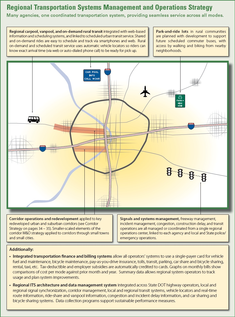
- The final page in this section outlines how a fully integrated Regional Transportation Systems Management and Operations Strategy could coordinate all system elements while supporting regional sustainability and local livability.
Multimodal Corridor StrategySuburban Corridor |
|
  |
|
|
BEFORE A. Through travel priority. Typical suburban corridor; signals timed to prioritize through traffic; extended delays for crossing traffic; limited pedestrian crossing time and crosswalks. B. Crossing conflicts. Mix of four through-travel lanes and two to three turn lanes on each side makes pedestrian crossings hostile and difficult; conflicts with turning and through-travel movements. C. Limited transit. Limited transit service, no transit stop amenities; no transit signal preference or real-time traveler information. D. No alternate routes. No nearby parallel roads. All local and through traffic mixes on main corridor, causing over-sized facility and negative impacts on operations and business access E. Poor sidewalks. Sidewalks present, but no separation from fast-moving traffic. Limited pedestrian access to businesses. No bicycle lanes or trails on or adjacent to corridor. No shade or lighting for pedestrians. F. Surface parking. Excessive surface parking for each business inhibits customer access by walking and transit, due to street set-backs and separation between buildings. Additionally... |
AFTER A. Balanced through & local travel. Tight urban grade separation provides free flow for through traffic and improves cross-traffic. Multimodal bridge supports walk and bicycle crossings and local circulator transit. Adaptive traffic signal control balances through and local traffic, pedestrian, and bicycle travel. B. Safer crossings. New landscaped pedestrian islands and left turn lanes provide pedestrian refuges and separated crossing movements from turning and through traffic. C. Enhanced transit. Expanded transit or BRT to serve new development includes transit signal priority, shelters and seating, real time traveler information, and bicycle sharing stations. D. Multimodal network. New local zoning codes (planned with corridor improvements) encourage transit-ready mixed-use development. New network of parallel roads, built with development, supports walking, biking, and circulator transit. Primary walking and biking routes are on adjacent roads. E. Great sidewalks. Wide sidewalks set back from traffic provide improved pedestrian operations and business access. Street trees for shade, landscaping for separation, and lighting for security improve pedestrian comfort and safety. F. Smart parking. New development provides ample shared use structured parking for residential and commercial use. Parking management district provides clear real-time parking availability and variable pricing information (for both on- and off-street) via web, smartphone, and signage. Parking provides car share stations (e.g., ZipCars), secure bicycle parking and lockers, and charging stations. Additionally... |
Multimodal Corridor StrategyThe pictures and captions on this page provide some details about the corridor strategy graphics on previous page. See text labeled with same letter (A through F) in the 'After' column under the corridor graphics. |
|
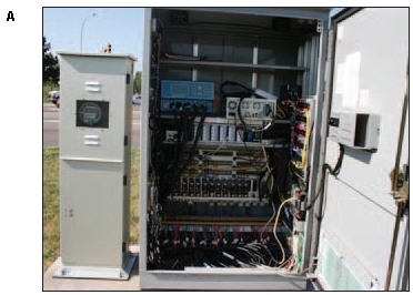 Balanced through & local travel. Adaptive traffic signal control balances queuing both for through traffic on the corridor and local traffic on the cross streets. Bicycle detector loops and pedestrian countdown signals improve bicycle and pedestrian travel. (Source: H. Liu, Assoc. Prof. of Civil Engineering, University of Minnesota) |
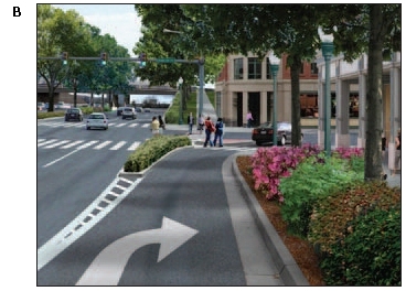 Safer crossings. Channelized right and left turn lanes with landscaped pedestrian islands can provide pedestrian refuges, while separating crossing movements from turning and through traffic. (Source: Urban Advantage, CD+A, & H.B. Rue for the Thomas Jefferson Planning District Commission, Albemarle County, and Virginia DOT) |
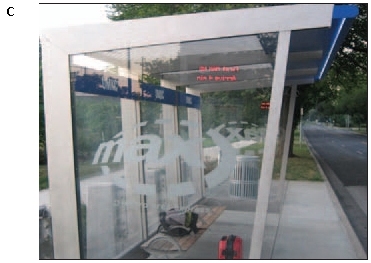 Enhanced transit. Stops include comfortable shelters and seating with real time traveler information. (Source: S. Trainor) |
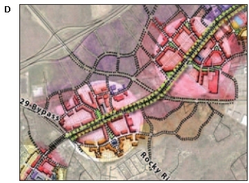 Multimodal network. A network of new roads parallel to the main corridor can be built around planned transit stations as development occurs, as shown in this concept design for U.S. 29 in Charlotte, NC. (Source: F. Dockity of Charlotte, NC) |
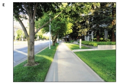 Great sidewalks. Wide sidewalks set back from traffic, street trees, landscaping, and lighting provide improved pedestrian comfort, security and safety. (Source: H.B. Rue) |
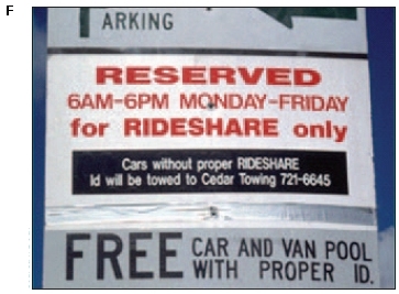 Smart parking. Active parking management can provide clear real-time parking availability and variable pricing information via signage, web, and smartphone. Priority parking for car sharing and vanpools can support increased use. (Source: F. Dock) |
Multimodal Corridor Phased Operations Plan
A corridor operations plan, integrated into a regional vision for a livable, sustainable community, can be implemented over time across multiple aspects of transportation planning, safety, land use, and operations. For example:46
- In year two, a safety project may fix a critical intersection problem, install new signal system technology, and improve intersections to Americans with Disabilities Act (ADA) standards.
- In year three, bicycle lanes are added as part of a planned resurfacing project. A new local comprehensive plan, based on the regional vision, is adopted and encourages transit-ready walkable, mixed-use development.
- In year four, the new corridor access management overlay zone results in closing several driveways, combining others, and adding sidewalks.
- In year five, a change in land use allows addition of channelized turn lanes, pedestrian islands, and connection of sidewalks to serve newly developed apartment complexes. New local zoning codes are adopted, based on the comprehensive plan, allowing more intense redevelopment near transit targets.
- In year six, an off-road bicycle connection, built as part of a new development, links to the region's trail system, while new and enhanced transit service is added to serve the corridor.
- In year seven, resurfacing and reconstruction resolves pavement deficiencies and adds a new cross-section, replacing an eight-lane undivided facility with six lanes, a landscaped median, and bicycle lanes throughout part of the corridor, with a four-lane divided section where volumes permit.
- In year eight, a roundabout resolves an upstream capacity bottleneck and serves as a gateway to the revitalized corridor.
- In year nine, new electronic signs are added that direct users to available parking with real-time parking data also available via web and smartphones.
- In year ten, an enhancement project permits re-landscaping the streetscape in the corridor and completes final bicycle and pedestrian linkages. Also, TSP is implemented as the commercial and residential developments continue. Each development is integrated into the interconnected local road, walking, bicycling, and transit network.
- In year twelve, a regional bus rapid transit system is implemented, focused on newly-developed transit targets. The BRT system relies on signal preference technology to maintain schedule, with traveler information provided to customers via next-bus signs at each stop, and via web and smartphone.
- In year fifteen, an urban-scaled grade separation at a key roadway crossing is added to improve both local multimodal travel and through traffic flow.
Regional Transportation Systems Management and Operations
The graphic on the next page outlines how the implementation of fully integrated regional transportation systems management and operations can help coordinate multiple transportation systems run by many agencies and operators, to provide seamless service across all travel modes.
Getting Started
The way a transportation system is operated makes a difference to community livability and sustainability, so it is vital to incorporate M&O strategies into livability-focused vision development, planning, programming, and implementation efforts. However, it can be difficult to know where to start and how to balance the needs of system users with broader community goals.
Comprehensively incorporating livability and sustainability strategies into systems M&O can appear overwhelming to the typical roadway or transit system operator; they are not typically included in the up-front planning that establishes a broad community or regional vision and goals. Fortunately, there are many smaller steps that practitioners, policymakers, and others can take to start this process.
- System Operators—Look into opportunities to incorporate livability and sustainability considerations into your current work. For example, a roadway operator could reach out to transit operators as part of a signal retiming program to find out how new signal timing could benefit bus operations. Roadway and transit operators can also approach local and regional planners to discuss how to integrate M&O approaches into the planning process. This can start with a request to be notified of any major upcoming planning efforts, especially those at the corridor or regional level.
- Planners—Reach out to operators to see how their current efforts and resources could help achieve longer-term goals. Incorporate M&O as a strategy in plans and discuss M&O benefits with the public, particularly as a short-term means to address multimodal system needs while larger projects move forward. Consider how M&O strategies could help meet community goals that may be identified through a corridor, regional, State, or neighborhood planning process.
- Decisionmakers—M&O strategies are often less expensive than capital improvements, and they can help ensure that system investments reach their full potential. Work with a wide range of partners to see how coordinated improvements in one area, such as transportation system management and operations, can have a positive impact on other areas, such as economic development or housing affordability and access. New partners may bring access to new funding streams and synergistic projects that can leverage multiple funding sources for implementation.
Some of the key themes that can help practitioners and policymakers move forward include:
- Create partnerships. Livability and sustainability solutions require input from a wider range of agencies and interests than may traditionally be involved in M&O or transportation planning. Reaching out to local planners, economic development groups, housing agencies, resource agencies, police and emergency management, businesses, land-owners, and other community groups is the first step in developing effective, integrated solutions.
- Engage with the community and stakeholders. Although using “systems management and operations” as the meeting topic is unlikely to draw widespread participation, M&O strategies can easily be incorporated into discussion of a comprehensive vision, integrated multimodal plan, and coordinated implementation. Framing M&O strategies as a cost-effective, phased implementation of a broader long-term vision can help generate support from the public and policymakers.
- Take a multimodal perspective. Maximizing the efficiency of existing system investments is a key M&O strategy. This can often be accomplished by “completing and connecting” the multimodal network with relatively smaller incremental investments in pedestrian, bicycle, and transit access improvements, as well as local roadway connections.
- Balance priorities. Recognizing the range of users and how their demands on the system vary—by mode, time of day, purpose, season, incidents and events, etc.—can help operators plan and manage the system to balance competing priorities.
- Recognize and emphasize the broader benefits of M&O. This primer has highlighted the range of benefits that M&O can bring to communities and the transportation system. For operators, emphasizing these benefits can help planners, decisionmakers, and the public understand the role of M&O in creating better communities.
- Pick a project; pick a place. Working together on a single project in a specific place—an intersection improvement, neighborhood plan, regional vision, or corridor plan—can be the best way to start incorporating M&O strategies into overall livability and sustainability efforts.
45 U.S. DOT, ITS Joint Program Office, "Integrated Corridor Management Systems." Available at: www.its.dot.gov/icms/index.htm. [ Return to note 45 ]
46 Example phased approach is adapted from Hamilton, Paul, “Implementing A Smart Growth Land Use Pattern To Manage Congestion & Safety By Integrating Regional Transportation Futures Alternatives Analysis With A Regional Concept of Management and Operations (RCMO): A Case Study in Performance Based Planning,” presented at Intersection Safety: Achieving Solutions Through Partnerships conference, March 2004. [ Return to note 46 ]

