| Skip
to content |
|
Urban Freight Case Studies - New York CityTruck Route Management and Community Impact Reduction StudyChanges in land use, regulations, and the nature of goods movement have brought about the need for improvements to the truck route network in New York City. As a result, the Truck Route Management and Community Impact Reduction Study was undertaken and published in May 2007. Through this study, the City performed an extensive analysis of the roadway network and developed a set of recommendations to improve efficiency of goods movement through its five boroughs. The recommendations included routing modifications, transportation policy changes, roadway signage improvements, enhanced enforcement, and educational initiatives. Truck Routing AnalysisThe infrastructure of New York City has long been established, and substantial modifications to physical structures are not likely. Changes in zoning have initiated significant redevelopment with many of the commercial and industrial districts of the past being rezoned, resulting in an influx of residential development. These changes have generated quality of life concerns from residents with respect to truck movement through their neighborhoods. In response to these concerns, NYCDOT developed a methodology to analyze the routing system and to reassess the truck route network that was last updated in 1982. NYCDOT collected data on several characteristics of goods movement in its five boroughs. They are:
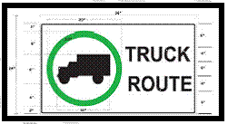
NYCDOT used the above data to analyze the system's efficiency and to develop solutions to existing problems. The appendix provides a short description of each data element. Best Practices ModelNYMTC developed the Best Practices Model (BPM) to forecast future travel patterns in relation to changes in land use and demographics in the study area, which included 28 counties in New York, New Jersey, and Connecticut.8 For more accurate results, commercial vehicle travel was modeled separately from person trips for assignment of vehicle trips onto the highway network. Model inputs for this analysis included vehicle classification counts, Origin/Destination (O/D) trip interchanges and O/D trip end estimates. The output provided from this model was commercial trip data by time of day for morning and evening peak periods.9 These data were then added to the model, along with other data, to produce the predicted travel patterns for the region. Geocoding10For this project, the addresses of truck crash locations were geocoded and displayed on truck route maps. Each intersection was assigned an x and y value so that it would be represented on the map as a point feature. Information on the number of crashes at a specific location and whether the location was on a designated truck route was stored in a reference dataset so that the data could be analyzed for patterns relating to geography. ImplementationBy the time NYCDOT's report was completed, two route changes had been made: a portion of the truck route network in the Bronx and one in Brooklyn had been realigned. The realigned truck routes improved the efficiency of goods movement and removed truck traffic from residential neighborhoods. Additionally, intersections with more than 15 crashes over a three-year period were flagged for improvements. Manhattan had reported 13 of the 15 crashes. Strategies to improve the safety of these intersections included signal timing adjustments, additional signage, and roadway geometric changes. Institutional and Coordination IssuesWhile collecting information on truck size and weight regulations in the City, NYCDOT discovered that various segments of the truck route network were managed by different agencies. In many cases NYCDOT, New York State DOT, PANY/NJ, and NYMTC did not coordinate with each other. This caused confusion among commercial vehicle operators and enforcement officials throughout the area. To mitigate this confusion caused by numerous regulatory agencies and rules, NYCDOT proposed the formation of the Office of Freight Mobility. This office, created in 2006, oversees the management and implementation of the Truck Route Study and related activities. Its responsibilities include, but are not limited to, educational initiatives aimed at informing truckers and the public about the truck route network, training of enforcement officials, and management of other goods movement. The development of such a department has alleviated confusion regarding freight regulations and serves as a contact for all truck-related concerns. Sign ImprovementsThe age of New York City infrastructure reflects older standards for street lane widths and curb radii. The truck route network was developed to guide large vehicles through the City on roads that can accommodate them. A system of both positive and negative signs delineates these paths through the city. In accordance with the Truck Route Management and Community Impact Reduction Study, NYCDOT initiated an improved signage program that provides easily identifiable, consistent direction to commercial vehicle operators in the area. As shown in Figure 5, the proposed truck-route signs will use the truck silhouette that has been in place in New York City for years and is used throughout the country. The city will introduce a color to the black and white truck route sign and use a new font in order to improve recognition and legibility. The positive signs—signs that assure truckers that they are on a designated route—will have a green circle around the truck. The negative signs will remain black and white to match the existing standard used elsewhere and will show the truck silhouette superimposed with the international sign for "do not." The positive truck route sign was conditionally approved. NYCDOT is waiting for full approval from FHWA. NYCDOT also will establish the consistent placement of signs. Three types of signs will be used: 1) directional signs, 2) advance signs, and 3) on-route signs. Table 1 provides a description and location for each proposed sign type. NYCDOT indicates that signage improvements will reduce reaction time, which will improve the traffic flow and safety. Figure 5: Sample Positive Truck Route Sign
Source: New York City Department of Transportation, Truck Route Management and Community Impact Reduction Study (New York City, NY: 2007), Technical Memorandum 3: Truck Signage Program. Table 1: Truck Route Signs and Locations
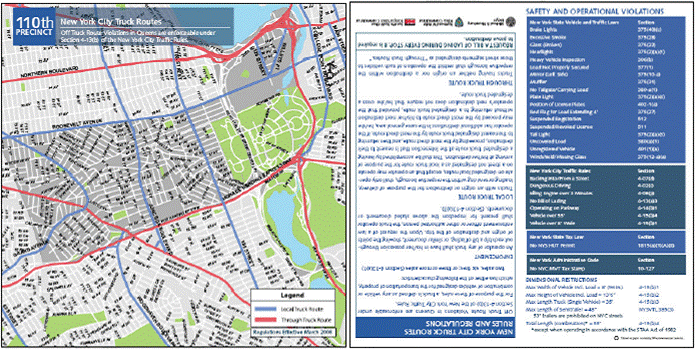
NYCDOT estimates that program implementation will cost $4.13 million.11 The cost includes the fabrication and installation of over 11,000 signs throughout the City's five boroughs. The City expects to realize significant safety and operational benefits from the improved signage. It should be noted that the signage program has not yet been implemented. NYCDOT is working closely with FHWA to finalize a pilot project that will test the signage program in the Bronx. Educational ProjectsNYCDOT developed a truck-focused Web page that provides information on truck-route rules and regulations. Truck-route maps also can be accessed on the site. In addition, more than 30,000 truck-route maps were mailed to the truck industry in 2007 to provide drivers with better information about New York City truck routes and truck size and weight limits. Another very simple, but effective, NYCDOT educational strategy addresses the truck-route information needs of the New York City Police Department (NYPD). Pocket-sized truck-route memo inserts were created and distributed to NYPD officers. Each memo insert, as shown in Figure 6, provides a truck-route map of an officer's precinct, truck-route regulations, and other enforcement information so that enforcement officials can better inform commercial vehicle operators about truck routes and restrictions. The Truck Route program is active in all 76 NYPD precincts.12 Figure 6: Sample Truck Route Memo Insert
Source: New York City Truck Route, 110th Precinct 7 New York City Department of Transportation, Truck Route Management and Community Impact Reduction Study, May 2006, page 4. 8 New York Metropolitan Transportation Council, NYMTC Best Practice Model (New York City, NY: 2002). 9 New York Transportation Council, Transportation Models and Data Initiative: Technical Memorandum No. 1.22, Final Model Structure and Framework, June 25, 1997, p. 315. 10 Geoding is the process of assigning coordinate values to datasets in order to represent information graphically. 11 New York City Department of Transportation, Truck Route Management and Community Impact Reduction Study, Technical Memorandum 3, May 2006, p. 53. 12 New York State Police, Commercial Vehicle Enforcement Unit, personal communication, May 20, 2009. | |||||||||||||
|
United States Department of Transportation - Federal Highway Administration |
||