Urban Freight Case Studies - New York City
APPENDIX
For the truck routing analysis portion of the Truck Route Management and Community Impact Reduction Study, NYCDOT collected data on the following characteristics of each of the borough's roadways:
- Vehicle Dimension and Weight Restrictions
To better understand truck size and weight restrictions, data was gathered on existing regulations as well as physical restrictions. The size regulations, established by the City of New York, were noted and taken into consideration. Information on restrictions due to overhead obstructions also was collected.
- Land Use
Land use also plays an important role in the location of truck routes. In the past 25 years since the City had updated its truck route system, New York City has experienced a growth in residential neighborhoods. This change has decreased the need for commercial-vehicle access in several locations, as well as increased resistance to truck traffic on roadways that were previously appropriate for trucks.
To assess the effectiveness of the existing truck route network and its impact on surrounding developments, NYCDOT produced maps illustrating land use patterns and truck routes for each of the boroughs. The agency analyzed the connectivity of the truck route network and identified potential areas of concern. Based on this analysis, the existing truck route network in each of the boroughs provided sufficient access to the commercial, industrial and manufacturing parcels located in the region. To determine whether some routes should lose their truck route designation, the agency looked more closely at roads that traveled through neighborhoods that were primarily residential (>75%).13 In some cases, these roads were removed from the network. However, in areas such as Manhattan, where a variety of land uses are found along the same block, the distinction between residential areas and commercial/industrial areas could not be made. In these mixed-use areas, extensive networks of local truck routes remained unaffected.
- Mobility
To ensure that the truck route network will serve future demand, NYMTC's Best Practices Model (included in the Regional Freight Plan) was used to estimate the volume-to-capacity ratio for all of the City's roads. These estimates measured the ratio of the demand flow rate to the capacity of each facility during the AM peak period for the year 2025. The model, which focuses on travel patterns based on changes in the study area's land uses, helped to illustrate which of the existing truck routes were expected to experience severe congestion and, therefore, might require further investigation as to whether or not they should lose their designation as part of the truck network.
- Truck Origin and Destination (O&D) Forecast
To better understand future truck travel, NYCDOT studied the origins and destinations of truck trips by Transportation Analysis Zone (TAZ). For analysis purposes, the department developed maps illustrating the existing truck route network compared to predicted truck traffic demand. These maps, which displayed the truck route network overlaid with graphics representing the number of truck trips generated by each TAZ, helped the City to analyze the current network's ability to serve the demands of estimated future truck traffic. Figure A-1 illustrates an example of the Truck Trip Ends map developed for the Borough of Brooklyn.
Using this technique, NYCDOT discovered several inefficiencies in the Through Truck Route network. The location of through routes in Brooklyn is one example of inefficiency. With only 50 miles of Through Truck Routes spanning along the western and northern borders of the borough, commercial vehicles are forced to use the 148 miles of Local Truck Routes for a majority of their trips. By designating additional through routes, NYCDOT could improve the efficiency of the through route network while rerouting truck traffic from local roads.
Figure A-1: Brooklyn Truck Trip Ends
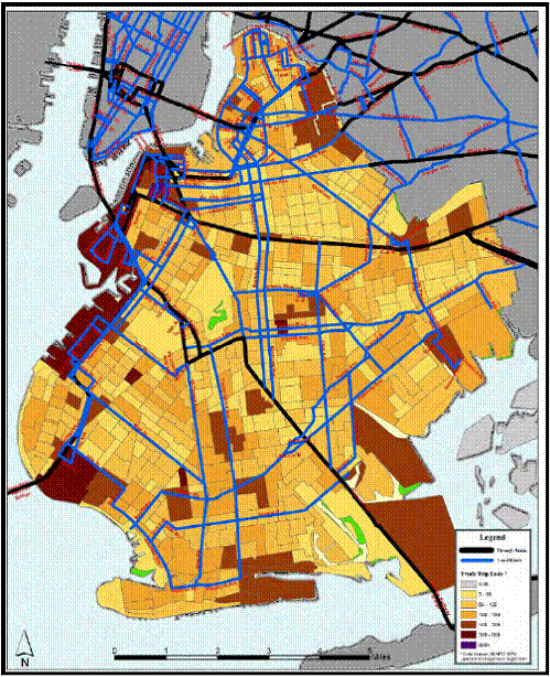
Source: New York City Department of Transportation, Designated Through and Local Truck Routes by Borough (New York City, NY:2009).
- Safety Data
Information on crashes involving trucks and trucking violations were collected for this analysis: 1) data of the location of all crashes in which trucks were involved over a three-year period, from 1999 to 2001; and 2) data of on-route and off-route crashes.
Using the three-year data, NYCDOT determined he location of crashes involving trucks and developed a list of the top 20 and top 100 locations. Analysis showed that these incidents were dispersed throughout the City. In fact, NYCDOT reported that 61 percent of intersections experienced one crash. The top 20 crash locations, ranging from 18 to 35 incidents during the three-year period, only accounted for 2.9 percent of the total number of crashes.14 Therefore, few locations stood out as requiring significant attention.
To better understand the safety history as well as the general usage of truck routes, crashes involving trucks were analyzed in relation to the truck route network. Using ArcView, the City's Geographic Information System software, NYCDOT developed a map that showed the number of truck-involved crashes and their locations throughout the City during a two-month period (from October to November 2003). By geocoding each crash site into the map, NYCDOT was able to determine the number of incidents that occurred at locations on and off the designated truck routes. The results indicated that a significant percentage (35 percent) of truck crashes during this period occurred at off-route locations.15 NYCDOT concluded that a considerable amount of truck traffic travels on restricted roads. This information was considered in the routing process and the development of other improvements.
- Truck Summonses Issued
To evaluate the nature of trucking violations in the City, NYCDOT obtained two sets of violation data from NYPD. The first dataset included a spectrum of violations including, but not limited to, trucking violations. Violations that could not be attributed to trucks were removed from the dataset. The second dataset included information on the location of displaced and over-height vehicles on or near parkways. Data collected by officers included the date, time, and location of the violation; trip O/D; where the truck entered the roadway; and the source of directions as reported by the driver.
- Truck-Generating Facilities and Areas
NYCDOT conducted analyses of the movement of trucks in the vicinity of truck-generating sites. Because of the study area size and project scope limitations, every truck-generating site could not be analyzed in detail. From stakeholder input and lists of "hot spots," the agency identified 71 truck-generating facilities. NYCDOT narrowed this list down to ten representative sites that would reflect the characteristics of similar sites throughout each of New York's five boroughs. The agency used criteria such as geography, type of use, safety history, and percentage of truck traffic for the sample.
These sites, which included distribution centers and commercial and industrial uses, were analyzed for their ability to efficiently move goods with minimal impact on the surrounding areas. Other factors analyzed include land use, zoning, the location of community facilities, access to truck routes, critical intersections, traffic operations, network capacity constraints, and crashes. Recommendations were developed specific to the problems of each of the ten selected sites. These recommendations included improved signage, designation of new truck routes, time restrictions, and intersection improvements.
- Stakeholder Issues
Input from various stakeholders was a key to the success of the Truck Route Management and Community Impact Reduction Study. NYCDOT involved individuals and groups with different viewpoints and concerns. Borough Commissioners were asked to share their knowledge of the area by identifying "hot spots" for truck activity. The Commissioners used their knowledge and input from many stakeholders, including local businesses, elected officials, policy precincts, and community groups to identify the hot spots. Once locations were identified, NYCDOT analyzed them and treated them as individual case studies.
The general public also was offered an opportunity to voice concerns and offer suggestions through various outreach efforts. Through open houses, phone, mail and email communications, surveys and other data collection efforts, NYCDOT received over 1,000 public comments.16 According to NYCDOT, meetings were held throughout the study to generate support from the community. Public involvement effort was an important component in the study.
previous | table of contents | next
|