| Skip
to content |
|
|
PDF Version [219KB] 
Measuring Cross-Border Travel Times for Freight
| |||||||||
Otay Mesa-Tijuana International Border Crossing |
The U.S. Department of Transportation, Federal Highway Administration (USDOT/FHWA) is conducting several projects to measure truck crossing and delay time at major U.S. land ports of entry. The projects will identify and evaluate technologies that 1) can easily and precisely measure commercial vehicle crossing time, 2) are readily transferable to other ports of entry, and 3) can measure passenger-vehicle crossing time.
FHWA's Office of Freight Management and Operations is measuring the time required for trucks to cross the Otay Mesa-Tijuana border and to establish a baseline dataset. The first phase of the project, now completed, identified Automatic License Plate Recognition (ALPR) and Global Positioning System (GPS) technologies for evaluation.
The second phase of the project is now underway and focuses on six tasks.
Task 1
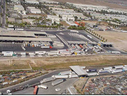
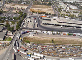
The project team identified stakeholders from the San Diego/Otay Mesa area, discussed their needs, and assessed impediments to collecting crossborder travel time data successfully. Stakeholders included representatives from motor carriers, state and local transportation planning and operations agencies, U.S. and Mexico customs, and FHWA. Together, the project team and stakeholders identified the intersection of Calle 12 and Bellas Artes as the beginning of the queue for trucks. This intersection is located southeast of the MX export lot (A in figure). The exit at the California Highway Patrol facility was identified as the end of the cross-border journey (C in figure). During peak season, which is from October to December, U.S. Customs and Border Patrol processes, on average, approximately 3,000 loaded trucks per day, and approximately 2,500 trucks per day from January through September.
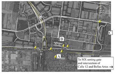
The physical layout of the Otay Mesa-Tijuana International Border Crossing is shown in a satellite photo. Lots and inspection facilities discussed in the caption are labeled 'A' through 'C.' Pushpin images representing measurement points are positioned along the highway route leading to and away from the border crossing.
Travel-time Measurement Sites, Otay Mesa-Tijuana International Border Crossing A is MX export lot, B is U.S. Federal inspection facilities, and C is CA Highway Patrol facility. The push pins in the figure represent measurement points along the border-crossing journey. Although FHWA is most interested in measuring travel time from point A to point C, the use of GPS technology enables measurement between any points represented by the push pins. |
Task 2
The project team matched stakeholder needs identified in Task 1 with the proposed technologies. Key considerations in evaluating the technologies included:
Based on these considerations, GPS was selected as the preferred technology. The Outreach/User Needs Summary and the Technology Evaluation reports have been completed and are available at www.bordertraveltime.com.
Task 3
The project team developed a data collection and test plan that describes the data capture and processing
methodology, including the high-level calculations that will be used to estimate travel times. This methodology is based on the elapsed time for vehicles to travel within and between key areas on the Otay Mesa-
Tijuana border. The plan and other project documents are available at the Web site noted in Task 2.
Next Steps (Tasks 4, 5, and 6)
The GPS measurement system is in place, and data collection and analysis will continue through Summer 2009 (Tasks 4 and 5). A final report (Task 6) will be
released in early 2010.
|
April 2009 |
Lisa Dye |

|
|
Office of Freight Management and Operations, 1200 New Jersey Avenue SE, Washington, D.C. 20590 https://ops.fhwa.dot.gov/freight, 202-366-9210 |
||
|
United States Department of Transportation - Federal Highway Administration |
||