Technologies That Complement Congestion Pricing—A PrimerApproach for Bundling TechnologyTechnology can enable the smoother performance of roadway facilities in which there is at least one managed lane. The variable pricing imposed on a managed lane may apply to vehicles that carry less than an established threshold of occupants; however, variably priced lanes without barrier separation from non-managed lanes are not operated on a distinct facility that may become operationally sensitive to the flow of the non-managed lane. Variably priced lanes that have some separation from the other non-managed lane may also be influenced. The challenge is to apply a set of layered technologies that work to sustain the available flow for both the variably priced and non-managed lanes. One example of coordinated technology exists on the I-15 corridor in San Diego. User fees are charged for single-occupant vehicles to access the HOV lane. Tolls vary dynamically with the level of traffic demand and are adjusted periodically in 25-cent increments. DMS, 511 traveler information, and Web sites communicate the adjusted charge to travelers along with information about travel time to select locations. Ramp metering is coupled with these technologies to further extend free flow and to delay the onset of congested conditions on the general-use lanes. Getting StartedBundling technology involves planning to make the technology application suitable to the agency’s business practices and to deliver desired outcomes. Many agencies have established transportation management centers to help better manage assets and to deliver a range of services to customers. Planning the Technology DeploymentSuccessful intelligent transportation system (ITS) integration and interoperability involve two different yet fundamental issues: technical and institutional integration. To address this, the National ITS Architecture was developed to provide a common structure for the design of ITSs. The National ITS Architecture provides a common framework for planning, defining, and integrating ITSs. It is a mature product that reflects the contributions of a broad cross-section of the ITS community—transportation practitioners, systems engineers, system developers, technology specialists, consultants, and others. The architecture defines the functions (e.g., gather traffic information or request a route) that are required for ITS, the physical entities or subsystems where these functions reside (e.g., the field or the vehicle), and the information flows and data flows that connect these functions and physical subsystems together into an integrated system. Establishing the National ITS Architecture enables agencies and other entities to coordinate their technology deployments to maximize operational efficiency and to minimize operation costs. Nearly every part of the United States has established regional ITS architectures to assist in their planning, design, implementation, and operation efforts. Establishing Transportation Management CentersTraffic management centers (TMCs) located throughout the Nation monitor and control traffic and the road network. These facilities manage a broad range of transportation facilities, including freeway systems, rural and suburban highway systems, and urban and suburban traffic control systems. The TMC purpose is to monitor and manage traffic flow and to monitor the condition of the roadway, surrounding environmental conditions, and field-equipment status. TMC operators coordinate with maintenance and construction managers to maintain the road network. They coordinate and adapt to maintenance activities, closures, and detours. Incidents are detected, verified, and incident information is provided to coordinate public safety response. Information is also provided to drivers and local media outlets. TMC operators are engaged in responding to a range of incidents, from minor traffic incidents to major disasters. When required, special traffic management strategies are implemented to support evacuation and reentry. The TMC supports HOV-lane management and coordination, road pricing, and other demand management policies that can alleviate congestion and influence mode selection. It also manages reversible- lane facilities and barrier and safeguard systems that control access to them. TMC operators in complex jurisdictional areas coordinate traffic information and control strategies in neighboring jurisdictions to promote the smooth flow of transportation operations across the available travel modes. Implementing Coordinated TechnologiesIntegration of various technologies can lead to substantial gains in transportation system performance and agency effectiveness. One can consider integration of the disparate technologies as the opportunity to make the whole system greater than the sum of its parts. Active Traffic ManagementActive traffic management is a concept that relates to the ability to dynamically manage recurrent and non-recurrent congestion based on prevailing traffic conditions. By focusing on trip reliability, it maximizes the effectiveness and efficiency of the facility. Active traffic management techniques aim to increase throughput and safety through the use of integrated systems with new technology, including the automation of dynamic deployment to optimize performance quickly and without delay. Active traffic management strategies include the following:
Lane-management applications, such as temporary shoulder use, speed harmonization, and lane control, are particularly favorable to supporting congestion pricing. These approaches enable an agency to reserve capacity specifically for HOVs and those vehicles subject to fee for use. This is achieved without penalty for travelers who use regular lanes, and it can be implemented rapidly for a much lower cost than building the additional capacity that would otherwise be needed. Temporary shoulder use has been observed in Europe to delay the onset of congestion and breakdown, increasing the overall throughput of the facility. In the Netherlands, for instance, temporary shoulder use increased capacity up to 22 percent and traffic volume by 7 percent. 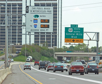
Minnesota dynamic pricing DMS for HOT lanes. An illustration of this is the demonstration in Minneapolis under the U.S. Department of Transportation’s (DOT’s) Urban Partnerships program. To create and manage priced dynamic shoulder lanes, the Minnesota Department of Transportation will use many advanced technologies. To ensure proper and safe-lane usage, dynamic lane-assignment technology— including light-emitting diode arrows, in-pavement markings, and the like—will direct motorists precisely to the appropriate sections of the roadway. DMS will inform travelers about the availability of the lanes for non-bus use, toll rates when the lanes are available, travel speeds on the priced lanes versus on the general-purpose lanes, and also transit alternatives (i.e., park and ride) to driving on the priced lanes. Electronic signage will also provide substantial information about arterial travel alternatives to freeways for drivers trying to avoid priced freeways and to bypass incidents.5 Speed harmonization has been shown to reduce the mean travel speed and the crash rate in various locations in the United States and Europe. This approach minimizes the speed variance among vehicles along the roadway, allowing for safer and smoother access to freeways. This approach is being applied more frequently, with new deployments in Orlando, FL, and Washington, DC, where there is localized congestion that can pose a crash threat for upstream vehicles. Reversible lanes can provide additional capacity for specific categories of vehicles (e.g., HOVs) or for priced vehicles by making use of unused capacity in the opposing direction travel lanes. This offers the opportunity to support bus rapid transit and other high-occupancy approaches while providing capacity on variably priced lanes. Integrated Corridor Management (ICM)Transportation corridors often contain unused capacity in the form of parallel routes, the non-peak direction on freeways and arterials, single-occupant vehicles, and transit services. These could be leveraged to help reduce congestion. Traffic information today is often fragmented, outdated, or not completely useful. Networks are often independently operated, and efforts to date to “reduce congestion” have focused on optimization of individual networks. The combined application of technologies and a commitment of network partners to work together have the potential to transform the way corridors are operated and managed. ICM optimizes the use of existing infrastructure and leverages underutilized capacity in urban corridors. ICM institutional partners manage the transportation corridor as a system rather than using the more traditional approach of managing roadways as individual assets. The integration of operations programs, such as traffic-incident management, work-zone management, traffic-signal timing, managed lanes, real-time traveler information, and active-traffic management, helps maximize the capacity of all facilities and modes across the corridors and allows for greater mobility. In an ICM corridor, because of proactive multimodal management of infrastructure assets by institutional partners, travelers could receive information that encompasses the entire transportation network. They could dynamically shift to alternative transportation options—even during a trip—in response to changing traffic conditions. For example, while driving in a future ICM corridor, a traveler could be informed in advance of congestion ahead on that route and be informed of alternative transportation options, such as a nearby transit facility’s location, timing, and parking availability. 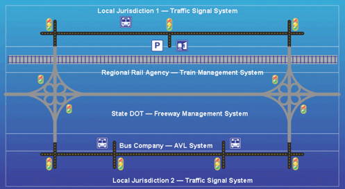
Integrated corridor management concept. AVL = Automatic vehicle location. Photo credit: USDOT DMS are assets to ICM corridors and congestion pricing alike. Adequate display of travel times and the current charges can inform travelers who are considering use of a tolled facility. DMS applications on arterials can have a profound effect on traveler behavior.6 Frequent traveler interaction with DMS and the traveler’s perception of the DMS messages enable the traveler to make a more informed decision to remain on the arterial or to enter the tolled facility. Because nearly all travelers use an arterial prior to entering a limited access facility, the decision-making process can be heavily influenced. A study on this arterial–DMS interaction in Wisconsin demonstrates that 66 percent of travelers diverted their route at least once per month. ICM relies heavily on the interaction of the freeway and arterial systems. Most critical in this interaction is the presence of real-time signal control. Real-time signal control for arterials that are intersecting the tolled facility can be combined with the application of DMS messaging to further improve the performance of congestion pricing. The performance of the limited access highway is often directly influenced by the performance of the arterial network with which it intersects. Adaptive traffic signal control is a progression beyond real-time signal control in which automated adjustments to the signal performance are made based on measured traffic patterns. This can effectively couple an arterial system to a freeway based on the dynamic traffic conditions on the freeway, allowing for a greater free flow of vehicles to and from the freeway. An example of this arterial management capability is demonstrated in Oakland County, MI, where the Road Commission of Oakland County implemented the Sydney Coordinated Adaptive Traffic System (SCATS). The SCATS provides the Road Commission with the capability to detect real-time demand and to adjust signal coordination to meet the demands. This helps to reduce congestion along freeway corridors and the arterial network by limiting unnecessary stops and by extending the green phases where demand is greatest. Central Business District ConsiderationsThe road space limitations for a central business district can be severe. The high density of commerce and livable space is known to generate a high number of trips, spreading the potential for congestion. Therefore, the challenge is to coordinate all the travel options to ensure that the use of road space is optimized. The congestion charging in the central zone of London demonstrates the benefits of addressing the challenge. The congestion charge, together with improvements in public transit financed with revenues from the charging system, led to a 15-percent reduction in traffic in central London, and a 30-percent reduction in travel delays. There was no significant diversion of traffic to local roads outside the congestion-charged area. An effort to conduct cordon or area charging needs to consider the demands for reliable transit and the safety of pedestrians and bicyclists. Travelers who enter the central business district or area in which pricing is implemented need to comprehend the charges they are incurring in order to motivate a modal change or other desired behavior. DMSs can be a tool to aid the traveler in comprehending the variable charges. In Singapore, variable prices are updated periodically and posed on DMSs for the different vehicle classifications. Commercial vehicles, motorcycles, and passenger cars are distinguished on these DMSs that are located throughout the central business district. Parking management systems may have information dissemination capabilities. They are most commonly deployed in urban centers or at modal transfer points, such as airports. They monitor the availability of parking and disseminate the information to drivers, thus reducing traveler frustration and congestion associated with searching for parking. Information on parking options needs to be provided to travelers who may elect to change modes to a lower cost alternative, such as bus rapid transit. This information is useful in providing positive guidance to motorists seeking a parking location by helping them determine the availability of parking space and the parking charges. A challenge in the central business district is the interaction of vehicles with pedestrians and bicyclists. Promoting the safety of pedestrians and bicyclists is critical in order to provide a sense of safety to those travelers who elect to change modes to transit, walking, and cycling, or a combination of the three. Pedestrian and bicyclist detection has been applied in locations throughout the United States in order to extend the crossing time on streets and arterials. Pedestrian-activated lighted crosswalks; specialized pedestrian signals, such as countdown timers; and bicycle-actuated signals can further improve the safety of all road users at signalized intersections and unsignalized crossings. These safety applications have proven effective in reducing the number of vehicle–pedestrian or vehicle–cyclist collisions that would impede the flow of vehicles in the charged area. Performance MonitoringAll the congestion-pricing strategies are data-driven programs that require effective data warehousing and performance measurement. Many transportation management centers ingest vast quantities of real-time data from various sources on the operational status of the transportation system. These real-time data are used to effect operational decisions that span from incident management to facility control. Agencies increasingly realize that the real-time information of today becomes the archived data that influence agency performance tomorrow. For example, archived data can be used to assess the need to adjust variable toll rates and to determine the magnitude of the adjustment that might be needed. Data CollectionReal-time data collection is essential for any agency that seeks to manage transportation assets. The value of a real-time information program to travelers is experienced at a personal level. Toll, transit fare, traffic, and travel conditions information is decision-quality information that allows travelers to choose the most cost-efficient mode, time of departure, and route to their final destination. This information should be easily accessed at a low cost in order to be useful to the average traveler. Timely and detailed information about transit vehicle arrival times, transit delays, traffic incidents, weather conditions, construction activities, and special events aid in improving travel time predictability, better choices, and reduced congestion. The value of a real-time information program to transportation agencies is greater control of system-wide transportation assets. Information collection and dissemination are critical for enabling public agencies to provide for efficient Interstate movement of goods and to reduce the level of congestion commonly experienced in metropolitan areas. Data Archiving and Performance MeasurementArchiving these data is critical to assess the performance of the transportation system based on decisions made at the transportation management center. Interpreting such archived data to determine the functional performance of the transportation network over time, to apply such performance-based assessments to prioritize capital and operating expenditures, and to set variable toll rates on congestion-priced facilities to maintain a consistent level of service is equally valuable. Continuous evaluation of the congestion-pricing strategy is critical toward maintaining the public confidence in the congestion plan. Any region that is implementing a congestion-pricing strategy should (a) consider the performance measures that are most meaningful for assessing the effective performance of the system and (b) provide information to the public on a regular basis. There are vast performance measurement opportunities from archived data. Eleven of the 12 performance measures defined by the National Transportation Operations Coalition are based on direct measurement of the transportation network.7 An additional potential benefit enabled through performance measurement and data warehousing is the depiction of benefits. Aside from time savings that the congestion-pricing schemes yield, travelers may be able to calculate their personal contributions toward carbon emissions. Through cordon pricing in its central business district, London reduced emissions of particulate matter and nitrogen oxides by 12 percent and carbon dioxide emissions by 20 percent. In a similar vein, both Singapore and Stockholm experienced measurable decreases in carbon dioxide emissions. These societal benefits can be expressed in personal terms; thus, individual travelers gain an appreciation for the personal contributions toward improving environmental conditions. Another benefit may be the ability of enhanced route planning to predict overall costs in advance of travel, thus establishing a basis for pre-paid travel for a predictable cost. This may enable goods movement delivery services to more fully predict the total cost of the congestion charges they may face and can allow them to transfer those costs to shippers or receivers. |
|
United States Department of Transportation - Federal Highway Administration |
||