1.0 Background and Purpose
Former NJDOT Commissioner Frank J. Wilson once stated that “transportation defines a civilization; it gives value to time, quality to life and energy to the economy.” If true, a State’s ability to manage the condition, efficiency, and performance of its transportation system directly affects the overall well-being and economic viability of the State. State Departments of Transportation (DOTs) are the primary state agency responsible for planning and programming mobility needs, as well as constructing, managing, and operating the statewide transportation system. Historically, short term needs and maintenance of transportation facilities has been the responsibility of State DOT operations departments, while long-term planning and capital programming has been the responsibility of State DOT planning departments. And in many DOTs these two departments have operated independently of one another, with limited interaction or overlap.
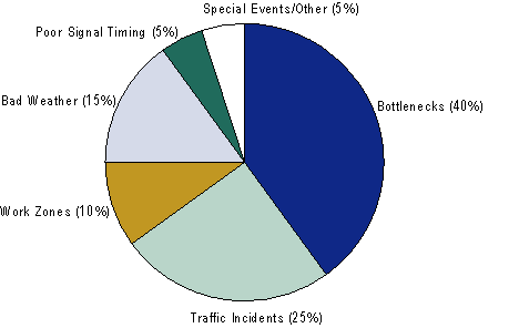
Traditionally, State DOTs have concentrated on mitigating recurring congestion by removing bottlenecks and improving poor signal timing. Often viewed exclusively as a big city problem, congestion reduction was achieved by increasing system capacity to meet demand. Building new roadways or adding additional lane miles is an accepted practice; one that focuses on the long-range planning process and requires major financial investments. However, the source of congestion in the United States is increasingly related to nonrecurring forms of congestion, such as traffic incidents, work zones, bad weather, and special events (Figure 1.1). Although nonrecurring congestion is a regular phenomenon, it is often inefficient, impractical, or counterproductive to apply standard capacity additions to these types of problems. As a result, new approaches and relationships are necessary to effectively diminish congestion and enhance mobility.
Figure 1.1 Sources of Congestion: National Summary (Traffic Congestion and Reliability: Linking Solutions to Problems, FHWA (July 2004))
Responding to the challenges and impacts of nonrecurring congestion requires cooperation among practitioners within different divisions of a state DOT and among Federal, State, regional, and local levels. Creating and sustaining linkages between planning and operations staff can help State DOTs to efficiently manage congestion. Resource limitations both in terms of funding and available land for new infrastructure investment, require that planning and operations staff focus on the efficient use of the transportation system.
State DOTs play a significant role in both planning and operating the transportation infrastructure, but most of the available reference materials that address linking planning and operations have been targeted towards the regional or metropolitan planning organization (MPO) level. To address this deficiency, the Federal Highway Administration (FHWA) has developed this primer for State DOT planning and operations staff to document the benefits of and the means to facilitate a cooperative relationship between State DOT planning and operations divisions.
1.1 What is the Purpose of this Primer?
This primer is designed to raise awareness of the benefits and opportunities for coordinating planning and operations activities within State DOTs, targeted at mid-level DOT planning and operations staff. To achieve this goal, the primer provides the following information:
- Descriptions of the relevance of planning to operations and operations to planning (Section 1.2);
- Organization of the current set of materials, projects, and documentation associated with the topic of linking planning and operations (Section 1.3);
- Identification of gaps and opportunities for linking planning and operations at state DOTs (Section 1.4);
- Description of steps that DOTs can take to better link planning and operations in several key areas, highlighted by case studies of State DOTs that have worked towards linking planning and operations (Section 2.0); and
- A self assessment questionnaire that State DOT planning and operational staff can use to help them understand how well they are linking planning and operations (Section 3.0).
1.2 Why Link planning and operations at State DOTs?
What value does linking planning and operations at State DOTs provide? This fundamental question must be answered before providing guidance on how to make those linkages. Linking planning and operations can improve transportation decision-making and the effectiveness of transportation systems by helping planners and operators consider the full range of relevant strategies to address regional goals and objectives. For state DOTs, linking planning and operations within the agency can also benefit the DOT’s relationship with regional and local partners and help DOTs better partner with those agencies to identify the appropriate solutions to specific transportation problems.
This section highlights the roles of planning and operations staff, the benefits of linking their functions for each, and the benefits for transportation system users.
Role and Benefits for Planning within State DOTs
Planning at the statewide level involves setting goals and objectives for the agency; identifying multimodal needs and deficiencies in the transportation system; scoping projects or strategies to address the needs and deficiencies; evaluating projects or alternatives; estimating the costs for the projects and strategies; prioritizing the potential projects and strategies to best meet the State’s needs over the short- and long-range; and in some cases congestion or performance monitoring. These are incorporated into several different planning efforts including statewide long-range transportation plans (LRTPs), Statewide Transportation Improvement Programs (STIPs), corridor or modal plans/studies (e.g., transit plans, corridor studies, ITS strategic plans, congestion management process (CMP), etc.), and congestion/performance monitoring.
- Statewide Long Range Transportation Plan. This plan is used by most States to identify the long range (20 to 30 year) goals, objectives, and priorities of the agency and, in some cases, to identify funding levels for specific programs and projects. The State’s long range transportation plan is one of the key opportunities for integration with operations, whether through identifying goals and objectives that address system management and operations, data sharing opportunities, identifying operational needs or strategies, identifying funding opportunities for ITS or operations, or other means.
- Statewide Transportation Improvement Program (STIP). A STIP is a financially constrained plan of scoped projects that are scheduled for implementation by a certain horizon year. The Safe Accountable Flexible Efficient Transportation Equity Act – A Legacy for Users (SAFETEA-LU), the most recent reauthorization of the nation’s surface transportation program, now requires that the STIP must be updated at least every four years. (The Safe Accountable Flexible Efficient Transportation Equity Act – A Legacy for Users (SAFETEA-LU), 23CFR450.216(a)) STIPs vary from state to state in coverage, but typically they identify the level of investment in specific projects and programs. Some States have begun to more closely link their STIP to their long range plans. The STIP represents an area of potential linkage between planning and operations. A few States have identified specific ITS and operations projects, strategies, or programs within their STIP.
- Corridor/Regional/Modal Studies. Most State DOTs conduct studies oriented towards specific corridors, regions, or modes. Linking planning and operations in this context typically includes addressing operational and intelligent transportation systems (ITS) solutions for a corridor or mode through its own ITS strategic plans or system management plans. These studies are often conducted by regional or metropolitan planning organizations as well; though State DOTs tend to lead these studies for nonmetro areas. These plans sometimes include an ITS or system management alternative, and in some cases integrate ITS or operational strategies within other traditional improvements as part of an alternative.
- Congestion/Performance Monitoring. Some planning groups at State DOTs are responsible for monitoring the performance of the transportation system, at the system, project, and/or program level. The assessments are used to evaluate performance (e.g., congestion, safety, accessibility, etc.) and provide input to make policy, process, procedure, and program improvements. Much of this performance monitoring is dependent on or can benefit from data that are collected and maintained by the operations groups.
For planners, collaboration with operators can:
- Foster greater consideration of day-to-day transportation system operations in developing transportation goals, objectives, and priorities;
- Help planners better understand how operational strategies can meet regional transportation goals and objectives;
- Support more comprehensive analysis of issues such as reliability, security, and safety that are difficult to address solely with traditional infrastructure investments;
- Provide access to system-wide, 24-hour travel data that can help characterize system performance and travel conditions, identify critical transportation needs, and prioritize funding; and
- Provide operations data and expertise to improve forecasts of future conditions, broaden the understanding of existing conditions, and analyze the effectiveness of alternative investments.
Role and Benefits for Operations within State DOTs
Operations is the active day-to-day management of the existing transportation system. It achieves its objectives through a customer focused approach that utilizes operations data collection, analytical tools, and performance measures to continuously monitor and optimize the operation and safety of the transportation system.
Operations activities are frequently grouped organizationally with maintenance activities. Maintenance activities typically include the daily upkeep and repair of the transportation assets, such as minor repairs to roads and bridges (crack sealing, pothole filling, etc.), responding to emergency repairs and incidents, snow and ice removal, and related concerns. Operational activities maintain the transportation system by managing the daily movement and flow of vehicles through the use of incident management systems, ITS technologies (such as ramp metering, signal timing optimization, message board and 511 crash/information notification systems), and related efforts.
Operations personnel have a solid foundation of data collection technologies and capabilities, as well as a working understanding of the day-to-day issues and condition of the transportation system.
For operators, collaboration and coordination with planners can:
- Provide increased opportunities and incentives for getting involved in the planning process, thereby helping to shape system goals and objectives;
- Clarify the role of operations in meeting the region’s transportation vision and goals and direct attention to the value of M&O strategies;
- Help operators have a greater understanding of how the long-range planning process can support M&O activities and how M&O activities fit into the context of regional goals and objectives.
- Provide regional leadership and greater participation by stakeholders in regional M&O efforts;
- Increase resources assigned to operations projects and programs.
Benefits for System Users
Ultimately, greater coordination and collaboration among planners and operators improves transportation decision-making and benefits the traveling public, businesses, and communities.
For system users, collaboration and coordination of planners and operators will allow for:
- Improved ability to address short- and long-term needs — Improved traffic operations information and understanding can help planners better predict future conditions and system improvements. It can also bring attention to operational improvements that can be implemented in a shorter timeframe than traditional infrastructure investments. This will lead to a more effective mix of operational, capital, safety, maintenance, and preservation investments.
- Improved reliability — Travelers and freight shippers are increasingly sensitive to unanticipated disruptions to tightly scheduled personal activities and manufacturing supply-chain processes. Yet trip times have become increasingly unpredictable due to the growth in nonrecurring congestion — unexpected or unusual congestion caused by accidents, inclement weather, special events, or construction. Growth in overall traffic volumes often means that even small disruptions can have a significant ripple effect on transportation system performance over a broad geographic area. Today, nonrecurring congestion accounts for about half of all travel delay. The planning process typically deals with ongoing or predictable congestion issues, and traditional infrastructure investments that do not address the disruptions that are the source of nonrecurrent congestion. Stronger connections between planners and operators help planners consider programs and strategies to improve reliability, such as deployment technologies to rapidly detect incidents; variable message signs and other approaches for providing quick, reliable traffic information to the public and media outlets; and use of roving incident response teams to quickly clear accidents to open up a roadways for full operation.
- Improved emergency preparedness — Coordination between planning and operations reinforces efforts ensure emergency preparedness and transportation security. Regional operations planning and flexibility a critical element of a secure transportation system. States and regions that advance operational flexibility in their planning and investment prioritization are building their capacity to address the myriad of emergency and security situations that could arise. addition, sources of funding may be available specifically for activities that support transportation security and emergency preparedness, which can be used to support transportation M&O objectives.
1.3 Quick Reference/Linking Planning and Operations
Linking planning and operations functions at State DOTs can help optimize transportation system performance by making better use of data and analytical tools and improving the overall understanding of the role of operations activities relative to other congestion mitigation strategies. Coordination between State DOT planning and operations divisions provides a unique outlet to exchange information and ideas about the same system, but from differing perspectives. Working together helps both parties productively achieve organizational goals such as reducing congestion on the transportation system.
In recent years, the topic of linking planning and operations has received significant attention. The FHWA reference guide Getting More by Working Together – Opportunities for Linking Planning and Operations was developed to address these issues at the regional level. Although most of the relevant literature to date has focused on linkages at the regional or metropolitan planning organization level, some resources have relevance to both regional and statewide levels. This primer uses the following five linkage opportunity categories both to organize previous and ongoing efforts in the area of linking planning and operations and to describe best practices for linking planning and operations at State DOTs:
- Data, Analysis Tools, and Performance Measures;
- Operations in Transportation Plans and Corridor Studies;
- Institutional (Coordination, Partnerships, Training, Organization, and Education);
- Regional Considerations; and
- Regulation and Policy.
Developing strategies to link planning and operations within State DOTs requires a solid foundation and understanding of current practices and techniques utilized by planning and operations professionals. To facilitate this effort, a “quick reference” of recent and current research publications was developed (Figure 1.2) and cross referenced with the five linkage categories outlined above. The reference material is divided into “primary” resources, those resources directly targeted to the category, and “secondary” resources, resources that are associated with the category. The graphic provides a high level summary of the substantial number of published and ongoing research efforts related to the topic of linking planning and operations.
The quick reference illustrates the association between primary and secondary documentation within each of the five linkage opportunities relevant to State DOTs. This reference also serves to guide users to documentation relevant to their needs. The reference section of this document (Section 4.0) provides a short narrative of each document in the quick reference along with a recent web-address (when available) for the document.
Figure 1.2 Quick Reference to Key Resources Within Linkage Opportunity Areas
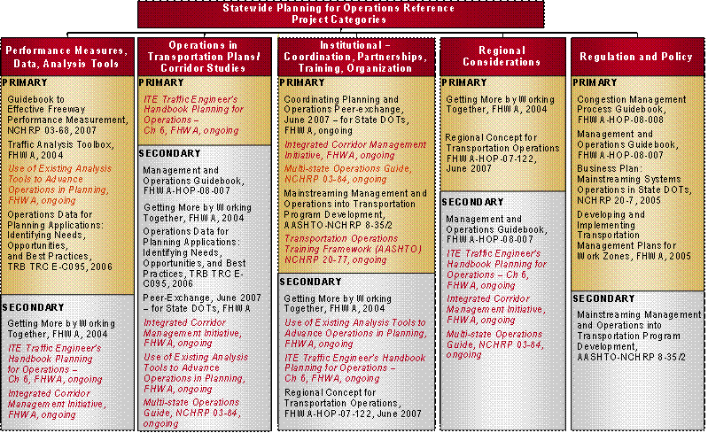
Key: Red Text: Document is currently not released and/or under development – Black Text: Document is published and available, see weblink or publication number.
1.4 Identified Gaps for State DOTs
This section identifies potential gaps in communication or intra-departmental coordination that may impede linking planning and operations. For each of the five linkage areas identified in the quick reference, potential information gaps or coordination opportunities are defined. Chapter 2 will investigate these gaps and identify resources to improve linkages between planning and operations. Case studies showcase specific lessons learned by DOTs attempting to address these gaps.
Data, Analysis Tools, and Performance Measures
Performance measures are recognized as having increased importance by State DOTs. With increased availability of data to support measures, agencies can better assess and respond to customer needs. Operational staff can collect significant data that may benefit the agency as a whole, but the data collected by operations personnel are not typically used in the traditional planning process. The following questions may help State DOTs address gaps associated with performance measures, data, and analysis tools:
- How can DOT staff become better acquainted with operations data and its possible uses and limitations?
- How can DOTs work better both within the organization and with regional partners to archive, manage, and share data?
- What types of performance measures and analysis tools can be used to capture the effects of operational strategies not captured using traditional planning methods and tools (e.g., nonrecurring delay and safety)?
- What planning analysis tools can benefit from operations data?
Operations in Transportation Plans and Corridor Studies
Transportation plans, corridor studies, and similar planning efforts provide key resources to formally capture the link between planning and operations. These studies are the substance of planning activities and present opportunities to engage in the other linkage areas identified in this primer. Operations data tailored or readily adapted to meet the needs of planning studies may greatly assist in developing planning studies that account for improved operations strategies. The following questions may help State DOTs address gaps associated with the integration of operations in transportation plans and corridor studies:
- How can operations be integrated into long range transportation plans, regional plans, or corridor studies that serve as a blueprint for future State transportation investments?
- How do current Federal requirements impact a planner’s ability to utilize operations data in planning studies and are methods available to tailor or adapt the data to meet the needs of planning studies?
- How can staff from different parts of the transportation organization contribute and support the development of the long range plan, corridor studies and other planning studies at the DOT?
Institutional (Coordination, Partnerships, Training, Organization, and Education)
The strength and potency of institutional structures are often an overlooked stumbling block that can make or break the ability to link planning and operations activities. The following questions may help State DOTs address gaps associated with institutional barriers expressed by State DOT officials:
- Who are the primary stakeholders within a given organization or for a particular project or program? How do stakeholders differ from decision-makers?
- When are formal memoranda of understanding (MOU) needed?
- How often and in what form should communications occur between stakeholders within a region?
- Do opportunities exist to inform and educate decision-makers and how do they occur?
- How can education and training improve an understanding of planning and operations activities and reduce barriers that hinder the exchange of ideas?
- Are there processes, arrangements, or established practices available to assist in developing partnerships to manage cross-jurisdictional projects?
- Are there any formal or informal forums or programs available within the organization that promote communication between departments?
Regional Considerations
The transportation problems faced by State DOTs transcend physical and political boundaries that govern the management and operation of the transportation system. As a result, increasing coordination and cooperation with regional partners and neighboring States can help maximize performance and efficiency. The following questions may help State DOTs address gaps associated with regional considerations:
- How can State DOTs improve their understanding and management of transportation issues experienced in urban, rural, and transitional areas?
- What programs or organizations are available to help manage interstate issues or projects?
- What benefits have been observed by bringing together the relevant parties to develop multi-state solutions?
- How can State DOTs look at statewide issues within a regional context and plan beyond one’s jurisdictional boundaries?
Regulation and Policy
Regulation and policy define State DOT areas of responsibility. Yet regulation and policy may limit an agency’s ability to try new approaches or techniques, even when the result may be improved efficiency and performance. The following questions may help State DOTs address gaps associated with regulation and policy:
- How can operational activities, which are often fiscally constrained, be linked to other programming activities within State DOT transportation budgets?
- How can support from the top be developed within State DOTs both organizationally and fiscally?
- How can an agency alter its strategic direction to improve support of operations activities?
- How does committing additional staffing and funding resource to operations and management activities improve the performance of the transportation infrastructure and the statewide transportation system as a whole?