Coordinating Military Deployments on Roads and Highways:
A Guide for State and Local Agencies
This publication is an archived publication and may contain dated technical, contact, and link information.
Chapter 5. Technologies Supporting Military Deployments
The previous chapters presented information that will help agencies plan and support a military deployment. This chapter describes available technologies and integrated technical systems which may assist in planning and operational support of military deployments. Individual technologies include such components as automated planning tools, basic communications devices, and advanced tracking and communications technologies. Integrated systems include the role of intelligent transportation system (ITS) technologies, Traffic Management Centers, and Emergency Operations Centers (EOC) in civilian, government, and military organizations.
Automated Planning Tools and Technologies
Three planning tools offer the greatest utility in assisting agencies and the military planners in organizing military deployments. The first is the highway conditions reporting system, which is typically developed by State highway agencies to provide a timely public source of information about travel and roadway conditions. Complementing the highway conditions systems are two specialized tools developed by the military transportation commands. These automated tools focus on the specific planning needs for military deployments. The first military planning tool is the Mobilization Movement Control System (MOBCON), which provides a Continental United States (CONUS) perspective of the roadway network and the proposed military deployments movements on the network. This dynamic system enables DMCs across States to plan convoy movements efficiently and deconflict their route planning. The second military planning tool is the Intelligent Road/Railroad Information System (IRRIS), which provides a suite of web-based tools for planning and tracking of assets. A discussion of these three automated planning tools follows.
Highway Conditions Reporting System
This system provides a comprehensive daily view of road conditions on a State's major highways and arterials. The conditions report is typically assembled daily by the SDOT at the district level and includes reports on planned work zones, construction, detours, road closures, and other planned events that may affect capacity and the safety of roadway travelers. Toll authorities have developed similar systems for their roadways, bridges, etc.
Almost all condition reporting systems are now Web-based with unrestricted viewing and printing access. The Web sites offer listings of roadway conditions by type of roadway (e.g., interstate, State highway), geographic location (county or SDOT district), and condition. These Web sites have been enhanced with additional technologies including linkages to personal digital assistants (PDA), pagers, e-mail, and other alert devices. Mass media providers and third-party vendors are developing more sophisticated condition reporting and navigation aids, sometimes on a fee-for-service basis. These systems usually draw heavily from the data sources of the SDOTs.
Mobilization Movement Control System (MOBCON)
While the Defense Movement Coordinator (DMCs) coordinate their planned and actual military movements with State agency officials, coordination among State DMCs is necessary to prevent major deployment conflicts or delays. The MOBCON system deconflicts convoys moving throughout the United States, allowing the DMC to control the density of military traffic at any given time on all State roads, freeways, and interstates. The convoy clearance function essentially gives units permission to occupy a particular road space at a specific time. The MOBCON system is not accessible outside of military transportation channels. Therefore, additional coordination between the DMC and State agencies is still required to ensure the system has the most accurate information about road closures, weather conditions, and other problems that may impede convoy route scheduling or affect convoys already in-transit.
Intelligent Road/Railroad Information Server (IRRIS)
The Intelligent Road and Rail Information Server (IRRIS) has been developed to enable rapid deployment of people, equipment, and munitions, and to improve the global deployability of U.S. armed forces. IRRIS is a Web-based system built on the concept of a portal, namely a means of viewing key data sources and information from other information providers in a consolidated location. Through a standard Web browser interface, IRRIS enables users to obtain detailed, timely, and relevant information about road conditions, construction, incidents, and weather conditions that might interfere with the movement of people and goods. It leverages the latest advances in information technology, Global Positioning Systems (GPS), Geographic Information Systems (GIS), and Location-Based Services (LBS) to provide decision makers with information necessary for efficient and rapid deployment of troops, equipment, and sustainment materiel between origins and destinations. This integrated system provides planners with a real-time tool for routing troops, equipment, and sustainment materials in the most efficient and effective manner and provides this information at any time, anywhere, on any Web-enabled device.
A detailed discussion of the components of the IRRIS system follows. The discussion contains a substantial amount of detail to illustrate the complexity of the military deployment planning requirements and the support gained from this automated tool.
![]()
IRRIS Components
IRRIS is the first software designed to combine highly detailed, local, and relevant information into one intuitive Web-based interface. IRRIS was developed in a modular fashion for greater flexibility. Figure 24 illustrates some of the IRRIS features. The following subsections briefly describe the major subsystems and functionality of IRRIS.
Detailed Mapping
IRRIS uses the latest GIS and mapping technology to provide users with comprehensive map drawing capabilities. GeoMedia WebMap is used to display high-quality mapping data as base maps and overlay numerous features on these base maps. IRRIS provides a method for selecting an area of study based on user-defined criteria, such as:
- PPP route map
- Strategic ports
- Power support platforms
- Critical depots
- Weather maps
- Fort-port area
- National Guard
- Continental United States (CONUS) overview map
- Installation area map
- Detailed installation map.
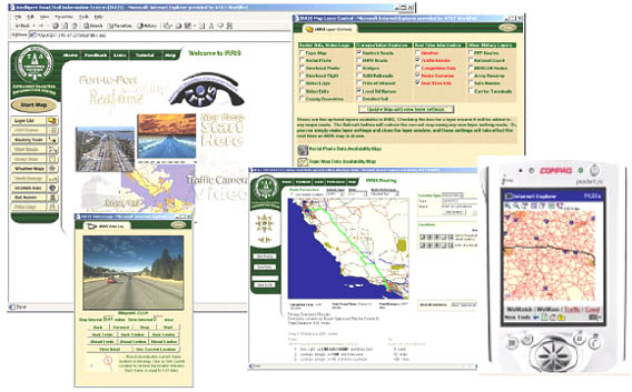
Figure 24. Detailed Mapping Features of IRRIS
One of IRRIS's strongest features is its ability to combine various sources of data (layers) and display them all in an easy-to-view, intuitive format. These layers may be toggled on or off at users' discretion. Most, if not all, of the layers also have their features identified and present attribute information for that feature either through "tool tips" or separate information screens. Map layers available to users include the following:
- Topography map
- Aerial photo
- NavTech roads
- National Highway Planning Network (NHPN) roads
- 1:2 M railroads
- Points of interest
- Local road names
- Detailed rail
- Bridges
- Weather
- Traffic events
- Overhead photo
- Overhead flight
- Route cameras
- National Guard
- MOBCON nodes
- Real-time information
- Video logs
- Video exits.
Vehicle GPS Tracking In-transit Visibility (ITV)
The IRRIS tracking subsystem allows users to:
- Accurately monitor and track the location of DoD freight traffic on a map in real time
- Cross-reference locational information with the Global Freight Management Systems (GFM) Bill of Lading (BoL) information
- Effectively and easily query both the raw locational and BoL data, and display the results in tabular and mapped formats.
At its simplest, the IRRIS tracking subsystem has two main sources of information about DoD tracked vehicles: locational information and BoL information from the GFM and/or the Defense Transportation Tracking System (DTTS). IRRIS enables its users to correlate these two sources of information, display the results, and query and report on these data sets.
Accurate Routing and Driving Direction
IRRIS provides its users with accurate and detailed turn-by-turn, address-to-address, or latitude/longitude driving directions with total driving time and mileage. It can also calculate routes to and from known points of interest, such as Army, Navy, and Air Force installations, airports, power projection platforms, etc. While considering real-time factors such as weather and road conditions, for example, the IRRIS routing subsystem is also capable of calculating the fastest or shortest route based on a variety of vehicle types such as E911, HAZMAT, auto, truck, and oversize/overweight (OSOW) vehicles.
Live Weather Maps
IRRIS provides accurate and highly local real-time weather information at the touch of a button. For highly timely data, the weather information is transmitted to the IRRIS weather subsystem through its own satellite receiver. The data are then organized and displayed on intuitive detailed maps. IRRIS weather data contains information not only on where a storm is but also where it is heading. By using Meteorlogix-enhanced NEXRAD (Next Generation Radar) radar information from the National Weather Service, IRRIS is able to provide forecasts of when a storm will arrive at a given site and how severe it will be.
Live Traffic and Incident Data
IRRIS provides access to the most extensive and complete real-time traffic information. IRRIS users are able to view live route cameras, fly-throughs, and video exits, as well as detailed traffic incidents, construction, and event data for 89 metropolitan areas within the CONUS. IRRIS will soon provide historic and predicted travel time and traffic data. These traffic data are intended to meet the long-term location-based needs of the military traffic management community by providing accurate and thorough transportability data and maximizing the use of modeling and simulation in deployment engineering.
Wireless and PDA Access
The IRRIS wireless and PDA components allow users to obtain information about road conditions, construction, incidents, and weather conditions while on the road. The wireless component of IRRIS is still in the development stages, but the goals are to enable its users to retrieve detailed information about the road and weather conditions from their current location, receive alerts about conditions ahead, and view maps and driving directions when they are needed the most. The wireless version of IRRIS will focus on allowing users to simply search, retrieve, operate on, and interact with the live interactive information available through IRRIS from handheld devices such as wireless access protocol (WAP) phones or wireless pocket PDAs. The IRRIS wireless subsystem has been designed to operate seamlessly and provide its users with maps, databases, and GIS data needed while on the road. It is designed to be easy to use and tightly integrated with other IRRIS components.
Database and Query Builder
IRRIS's Query Builder guides users through the process of building sophisticated database queries in order to view textual data in a tabular format. Managers, data analysts, and report builders are empowered with on-demand access to data in order to make better business decisions. IRRIS's Query Builder also enables users to display the results of the query on a map. This mapping functionality enables users to view results in different ways and provides a complete and accurate picture of the data without requiring users to write complex SQL statements.
Additional information is available by contacting the Surface Deployment and Distribution Command Transportation Engineering Agency (SDDC TEA) at https://www.irris.tea.army.mil/SelectWelcome.asp for password procedures.
Basic Communication Devices Used During Convoy Operations
The primary means of communications with convoys during operations rely on proven land-based technologies, namely telephone systems, cellular systems, and radio systems. However, current deployment communication systems involving military and civilian communication systems have interoperability problems. Current communication systems essentially rely on telephone lines to move information from one area to another. The following communication challenges have been identified:
- Radio systems between military and civilian agencies supporting deployments are not compatible.
- A lack of signal repeaters along the routes limits the range of radios to communicate back to the installation or port.
- Users of cellular phones experience gaps in coverage and periods of nonavailability.
- Route change information would be difficult to pass to the convoy commanders on the move.
- Cellular phones are not issued to convoy commanders. They typically use their personal cellular phones.
Land Line Telephones
Telephones are the primary means of communication and coordination for deployment operations. Typically, these lines are only available at fixed facilities. Telephone contact lists are available in the military and civilian command centers and they must be updated at least every 3 months or more frequently based on the number of personnel changes and turnovers. Moreover, these lists must be promulgated to key State agencies, such as law enforcement, emergency management centers, SDOTs, and others.
Cellular Phones
Most convoy commanders use their own devices (phones, PDAs, etc.) to communicate unclassified information with the Installation Operations Center/Movement Coordination Center (IOC/MCC) and other support agencies along the route. Gaps in coverage, frequency or protocol incompatibility, and system overload may limit cellular phone capabilities.
Tactical Radios
Communications within the convoy are conducted using tactical radios. These radios have a limited range and are not compatible with civilian radio systems due to security concerns.
To address some of these technical interoperability issues, more advanced technologies have been developed and introduced. These newer components and systems utilize different technologies (such as satellite communications) or enhancements to the existing basic communications systems. The following sections discusses some of these advances.
Advanced Communication Devices and Systems Used During Convoy Operations
The DoD is currently going through a transformational period. It is harnessing new capabilities to provide full spectrum information dominance of the battlefield through global communications and visibility tools. These advanced technologies are also useful during convoy operations. The following subsections describe individual components and integrated systems being developed and incorporated into the DoD's Global Combat Support System (GCSS).
Movement Tracking System (MTS)
MTS is a commercial off-the-shelf (COTS) vehicle tracking and communication system that allows two-way text messaging based on satellite technology. This system is ideal for sending text messages to and from the vehicle and identifying the location of vehicles without having to query the driver. The system provides highly efficient, fast, and secure communications over satellites specifically for mobile data communications. This messaging and communicating capability provides enhanced communication ranges—well beyond the traditional line-of-site mode with conventional military and civilian radios—which greatly enhances the military's capability over long distances (greater than 75 miles). Embedded within the system is an automatic GPS function that generates position reports, which can be captured in data processing systems and/or provided on screen displays.
Figure 25 illustrates the key components of MTS. Configurations are modified to meet military or civilian needs such as security and type of data to be exchanged. Greater interoperability of these systems will allow the SDOTs and other authorized State agencies to interact with military deployments to obtain more real-time tracking and location information.
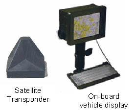
Figure 25. Key Components of a Typical MTS
Radio Frequency Identification Technologies (RFID)
Radio frequency identification (RFID) technologies are being used by the military to provide visibility of items moving across the Defense Transportation System (DTS), as well as for asset visibility. RFIDs are a type of automatic identification system that has been available in commercial systems for a number of years. An RFID system enables data to be transmitted by a portable device called a tag. A tag is activated by an RFID interrogator and then transmits data stored on it. That information is read (by RFID), processed, and stored according to the needs of a particular application or information system. Typically, applications are in the fields of logistics, inventory control, rail yard asset management, and vehicle tracking. Figure 26 shows a typical military application.
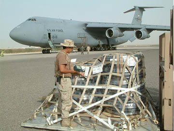
Figure 26. A Soldier Scanning an Active RFID Tag for Manifest Data
The tag transmits data that may provide identification, location information, or specifics about the tagged items, such as item-specific detail or shipping documentation. The tag might also point to a historical database where such information is stored and applications use the data for different purposes. RFID use in tracking and access applications first appeared during the 1980s. It quickly gained attention because of its ability to track moving objects and its non-line-of-sight data transfer capability. This enables tags to be read through various substances, such as snow, fog, ice, paint, dirt, grime, and other visually and environmentally challenging conditions, conditions in which barcodes or other optically read technologies would be useless. RFID tags can also be read at very high speeds, responding in less than 100 milliseconds, even in challenging environments. Because of its versatility and performance, RFID has become indispensable for a wide range of automated data collection and identification applications.
DoD has developed policy to support the implementation and use of both active and passive RFID tags to enhance visibility of items across the Department by the end of calendar year (CY) 2005. This policy primarily grew out of the military's need for enhanced asset visibility moving through the DTS, for logistics planning, and from operational requirements that emerged during Operation Desert Shield/Desert Storm, Operation Enduring Freedom, and Operation Iraqi Freedom (OIF).
Active RFID tags are battery powered and can store and transmit large quantities of data (up to 512 kB) when within range of either a fixed or a hand-held RFID reader. This read range is usually up to 100 meters but is limited by their battery-life. Active tags will primarily be used on aggregated and consolidated shipments of items on pallets, containers, and on major end items such as trucks. Figure 27 illustrates a variety of tag types, fixation points, and mobile interrogator subsystems.

Figure 27. Variety of RFID Tags
All of the asset data are stored in DoD systems of record, which provide enhanced visibility of troops, equipment, and sustainment materiel moving through the DTS. Systems like IRRIS further synthesize these data to create a visualization and integration of authoritative and comprehensive information. Comprehensive sources provide a common operational picture for the military to support logistics planning activities and identify possible choke-points and bottlenecks in the transportation network. Currently, these logistics visualization and integration systems are undergoing further development and refinement, and will evolve into an authoritative source—GCSS. As these systems are fully developed and deployed, they will provide the military and their stakeholders with more real-time, synthesized, and actionable data that can support military decision-making, deployment, and distribution processes.
Satellite Communications Systems
Enhanced satellite communication systems with receivers and transmitters in operations centers, command posts, and command vehicles greatly improve deployment communications. In the realm of the military combat service support function, the Army and Marine Corps are experimenting with Very Small Aperture Terminal (VSAT) satellite communications systems. Designed to be highly mobile, VSATs are easier to deploy and employ, not dependent on a large communications backbone, and are able to operate in harsh environments. Figure 28 illustrates an example of a mobile military satellite communications system. These VSATs will be able to transmit logistics data from anywhere in the world via satellite. To maintain proficiency with the systems, the Army and Marine Corps plan to use them at home stations as well as when deployed. These systems are very similar to the satellite dishes used by many commercial entities to transmit data across their enterprise. However, these VSATs have an additional level of information security and encryption given the nature of the information they transmit and receive. VSATs are about 18 inches in diameter and have been in commercial use for years.
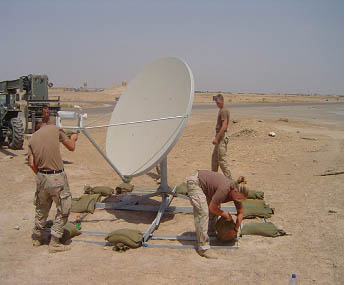
Figure 28. Example of a Mobile Military Satellite Communications System
Using Existing Systems Alternatives
When conventional communication methods are ineffective or not available, passing information to a convoy on the move could be accomplished by involving a regional State police dispatch center. For instance, convoy reroute information could be called into a regional, 24-hour dispatch center, which could relay information concerning the convoy's approximate location and route change information via radio to a State police officer. The officer would then locate the convoy and verbally pass the information to the convoy commander. The effectiveness of this type of approach depends on the availability of proper call lists and training of the officers on duty.
Integrated Technical Systems Used During Convoy Operations
The previous sections discussed individual technologies which may assist in the planning and operations of military deployments movements. While these component technologies offer valuable capabilities, such as communications and asset tracking, they become even more valuable when assembled into a system of technologies. Substantial advances in technology which support the movement of people and goods has occurred in the area of intelligent transportation systems (ITS). ITS includes not only component technologies, but the integrated application of the components to assist with system-wide mobility and public safety, especially when consolidated into a traffic management center. Likewise, agencies have gained planning and operational efficiency through the development of emergency operations centers, in which multiagency representatives, coupled with advanced technologies, are able to respond to emergency situations. Each of these systems can make a positive contribution to the coordination of military deployments.
Role of ITS Technologies
ITS technologies collect, store, process, and distribute information related to the movement of people and goods. Examples include systems for traffic management, public transportation, emergency management, traveler information, advanced vehicle control and safety, commercial vehicle operations, electronic payment, and railroad grade-crossing safety. Figure 29 illustrates one such portable device for use in work zones, which may minimize military convoy delays.
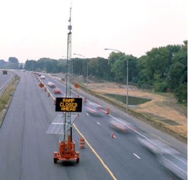
Figure 29. Portable Traffic Control Devices Can Assist with Work-Zone Activities
If gathered and distributed in a timely manner, some items of information can positively affect transportation system function and safety. Information collected and used in ITS can benefit a range of users, including military deployment planners and commanders. To be effective, a unified framework or architecture for integrating ITS components is needed and must be followed. ITS technology implementation will require multidisciplinary resources and expertise, including the military. Figure 30 demonstrates the relationship between ITS and military deployment requirements.
| Applicable ITS Technology | Purpose | State-of-the-Practice |
|---|---|---|
| Military Deployment Concern—Oversize/Overweight | ||
| Weigh-In-Motion Systems (WIM) | Eliminate requirements for vehicle stops and weight checks. | Approximately 10 states have some form of WIM. Increasing use by other states. |
| Electronic Vehicle Screening | Provide pre-clearance for commercial vehicles for safety inspections and port-of-entry processing locations. Saves time by eliminating vehicle stops. | Approximately 15 states have some form of pre-clearance program. |
| Commercial Vehicle Information Systems Network (CVISN) | CVISN is an integration of information systems and networks designed to enhance motor carrier and roadway safety and improve the performance of commercial vehicle operations and state regulations. | Approximately 35 states have implemented some form of CVISN architecture or program area. |
| Military Deployment Concern—In Transit Visibility | ||
| Automatic Vehicle Identification (AVI) and Automatic Vehicle Location (AVL) | Use of on-board transponders technology with remote receivers to automatically identify and locate vehicles. | Increasing usage, especially in the commercial vehicle industry and transit industry. Signals can be encrypted. |
| Archived Data Services | Use of archived data from the SDOTs or TMCs to understand nominal traffic patterns during in-transit movement. | Archived data is starting to be used to assist with baselining and planning activities. |
| Closed Circuit Television (CCTV) | Observe real-time road conditions. | Widely used in regional traffic centers resulting in high-quality color images with full Pan/Tilt/Zoom imaging and storage capabilities. |
| Military Deployment Concern—Safety | ||
| Collision Avoidance Systems | Use of on-board sensors and other devices to warn drivers of impending collisions and erratic lane changes. | First generation devices available on some commercial and personal vehicles. |
| Biometric Safety Aids | Use of biometric technologies (retinal scans, facial recognition, fingerprint identification, etc.) to ensure safe and authorized operation of equipment. | Emerging technology with limited field-testing and implementation. |
| Grade-Crossing Collision Avoidance Systems | Use of advanced sensor technologies and warning devices to reduce the number of vehicle-train collisions at at-grade crossings. | Increased installation of the equipment, especially at sites with high accident records. |
| Military Deployment Concern—Assured Access to Roadways | ||
| Traveler Information Systems (including "511" telephone services) | Provide basic information about roadway conditions, work zones, incidents, recurring congestion, expected delays, and possible alternative routes. | Emerging national network on road closures and traveler information. 511 traveler information services available in 25 major metropolitan areas. See www.fhwa.dot.gov/trafficinfo. |
| Weather Advisory Systems | Provide current and forecasted weather information that may affect roadway conditions and/or travel. | Information usually coupled with roadway conditions reporting systems. Some commercial services available. |
| Emergency Response Systems | Provide quicker response in case of on-road emergencies, potentially saving lives and clearing incidents more quickly. | Developed in various forms, including integrated incident management teams, enhanced communications equipment, E911 services, and others. |
| Synchronized Traffic Control Systems | Improve time-of-day adaptive control of signal networks. | Limited, but growing, application in major metropolitan areas. |
| Signal Pre-Emption Systems | Allows emergency or special vehicles priority access through signalized intersections. | Limited, but growing, application in major metropolitan areas. |
| Dynamic Message Signs (DMS) | Provide information about roadway conditions and possible alternative routes, as needed. | Increasing use of DMS, especially in major metropolitan areas. |
| Highway Advisory Radios (HAR) | Provide localized traveler information on AM frequencies near areas of interest, work zones, or incidents. | Widely used by almost all states. |
| Ramp Metering Systems | Control the volume of traffic entering a freeway to help maintain a desired level of service on the freeway. | Systems installed and operating in several metropolitan areas. |
| Electronic Toll Tags and Tag Management (ETTM) | Use of short-range communications equipment and protocols to automatically debit an account for toll facility usage. | Used in many states. Increased usage expected. Saves time in processing at collection points, thereby minimizing congestion. |
Additional information about ITS technologies can be found at www.its.dot.gov.
Traffic Management and Emergency Operations Centers During Convoy Movements
Traffic Management Centers (TMC) are a consolidated and organized means of actively monitoring and managing roadway conditions in a specific geographic area, usually a major metropolitan area. TMCs provide the public with conditions and management reports through Web sites, partnerships with mass media, telephone reports, and other means. TMCs usually operate 24x7 and provide freeway condition reports, including incidents, congestion points, transit operations, and freeway operations. Much of this information is acquired through ITS technologies, which may include closed-circuit television (CCTV), roadway loop sensors, probe vehicles, Automatic Vehicle Location (AVL) systems, weather reports, emergency response reports, information from citizens, or commercial vehicle operations (CVO), and other sources. Figure 31 illustrates a TMC field camera view provided by TranStar. Because a TMC monitors, analyzes, synthesizes, reports, and manages (to a certain extent) the freeway system, it represents a desirable source of information and operational coordination during military deployments.
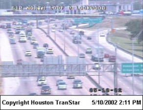
Figure 31. Traffic Management Centers Such as TranStar in Houston, Texas, Give a Live View of Current Weather and Traffic Conditions. These Views Can Be Accessed by All Agencies Through the Internet
A TMC involves one or more agencies with varying levels of involvement based on State, local, and regional organizations and jurisdictional authorities. Participants include the DOT (State and/or local Department of Public Works [DPW]), transit authorities, police, fire, and/or emergency services providers. A TMC is usually owned and operated by the SDOT, although some TMCs are owned and/or operated by other agencies or authorities, such as a transit system or toll authority. Some TMCs can control high occupancy vehicle (HOV) or special access lanes that may be desirable or required during deployments. TMCs may also influence signal timing and ramp metering to improve freeway operations. Almost all TMCs coordinate freeway patrol units and incident management responders, all of which can affect the efficiency of deployment operations.
Role of a TMC During Convoy Operations
A TMC's primary role during normal civilian operations is to monitor freeway conditions, report unusual conditions to the public, and coordinate rapid and safe incident management on freeways. As noted previously, it is desirable for the convoy to avoid major metropolitan areas during periods of rush-hour traffic, typically between 6 a.m.–9 a.m. and 4 p.m.–7 p.m. on weekdays, although these times may vary based on location and special-event conditions. If special events are planned in a TMC's coverage area, the TMC is likely to be aware of freeway traffic implications and can share them with the DMC and other convoy planners, who can then assess the desirability of a proposed route.
During a convoy deployment through a TMC coverage area, the DMC should alert the TMC as to the approximate time, size, and duration of the convoy movements. Moreover, the TMC should be notified if there are special materials or travel conditions associated with the convoy. This information will allow the TMC to prepare for any special contingencies that may arise.
During a military deployment in a TMC coverage area, the TMC typically makes no operational changes. However, the TMC's roadway condition information will be valuable to the convoy commanders. Convoys will normally stop outside of a major metropolitan area to check load straps, refuel, and confirm route information. During this planned stop, a well-coordinated discussion between the convoy commander and the TMC can ensure the convoy's safe and efficient passage through a metropolitan area based on the most recent freeway condition reports. For example, if there is a major incident along the planned and approved deployment route, the convoy commander would need sufficiently detailed information to determine if a change in convoy operations is needed—a change in route, temporary or extended rest stop to allow the incident to be cleared, or other possible courses of action, for example. Consequently, convoy planners will need to plan and implement communications systems that enable the DMC and convoy commanders to capture this type of real-time information.
If a specially designated route—as requested by the DMC—is through a TMC coverage area, the TMC would help State and local authorities prepare, manage, and restore roadway travel conditions necessitated by the special route. Such a situation may be necessary during other special events—a presidential visit, major sporting event, and other events for which event-driven protocols have usually been established. During these special events, the TMC is prepared to help the responsible agency in planning and operational requirements. The DMC would need to coordinate closely with the TMC to ensure this coordination and preparedness occurs.
Emergency Operations Centers (EOC)
Federal, military, and civilian agencies use EOCs to control aspects of an emergency, incident, or major operation. Typically, EOCs are command and control nerve centers equipped with enhanced communications where representatives from various departments and agencies can meet and work to control or react to emergencies or major operations. SDOT and emergency management (EM) agencies have a responsibility to communicate and exchange vital information during an emergency. This often requires that plans and contacts are established and maintained routinely. The following sections describe the responsibilities and capabilities of some of these military, government, and civilian EOCs.
Military EOCs
Military operations centers dealing with a deployment are usually at the deploying installation and ports of embarkation. Intermediate command posts may also be found along convoy routes.
Installation Operations Center (IOC)/Movement Coordination Center (MCC)
When an installation is issued a notice to deploy, it activates the MCC as part of the IOC. The IOC is the controlling activity to coordinate deployment operations and will be staffed to coordinate operations, intelligence, logistics, and administration functions. The key components of intelligence and logistics are highlighted below.
Intelligence. Installation intelligence personnel provide threat information to the commander and the convoy commanders; this information can be related to military facilities, equipment, information systems and personnel—both on and off the military installation.
Logistics. The Logistics MCC function of the IOC coordinates the following:
- Providing all necessary support services and transportation requirements of the deploying units.
- Establishing and operating a marshaling area to support the reception of the moving convoys at the port.
- Establishing, training, and equipping a PSA to support surface movement of forces traveling through the assigned SPOE.
- Directing the activities of the installation unit movement coordinator (UMC) and unit movement officers (UMO) during the deployment process.
- Coordinating convoy route approvals and alterations with the DMC.
- Communicating route changes or time adjustments to convoy commanders before departure or en route. En route changes are relayed to commanders at rest/refueling stops via cell phone, police escort, or law enforcement dispatchers.
Seaport of Embarkation Operations Center—Joint Military/Civilian Center
On notification of a deployment with established port calls, port officials and support agencies meet to establish priorities and, usually, establish a formal operations center on the arrival of port support activity (PSA) personnel from the deploying installation. This operations center is responsible for coordinating the following:
- Overall supervision and management of PSA and convoy operations.
- Lodging, meals, and return transportation for personnel supporting port and convoy operations.
- Port labor.
- Port security requirements.
- Convoy staging areas.
- Communication with the IOC and MCC.
Civilian EOCs
Although civilian EOCs are not specifically designed to control or facilitate convoy movements, they can be a useful central point of contact to help resolve problems involving convoy operations. Civilian agency representatives in these EOCs are accustomed to working together to respond to and recover from emergencies.
State EOCs
The State governor customarily activates the State EOC during times of disaster or emergency. This EOC brings together State agencies to coordinate and prioritize the use of critical resources. The following State agencies and organizations may have a role in deployment operations from the State EOC:
- Department of Transportation
- Department of Public Safety
- Office of Emergency Management
- State Attorney General
- National Guard
- Volunteer organizations active in disasters (American Red Cross, Salvation Army, and other disaster services organizations).
The State EOC can communicate directly with all county/parish emergency management offices, all State police troops or districts, and Federal agencies. In this way, the State EOC can provide an excellent communications backup for deployment operations.
Regional EOCs
Some states have regional EOCs that coordinate the disaster/emergency response of multiple communities within a geographic region. Like the State EOC, regional EOCs can communicate with regional agencies. A regional EOC can coordinate assistance to convoy operations moving through its region.
County/Local EOCs
Many counties and parishes in the country have EOCs and respective emergency managers. In these centers, county/parish agencies and volunteer organizations come together to deal with emergencies, disasters, or special events. These EOCs have direct communication with local law enforcement, fire services, and EMSs within their jurisdiction. In addition, they are accustomed to working with the State EOC to resolve emergency-related problems.
State Department of Public Safety (SDPS)/State Police Dispatch Centers
These centers have the ability to become operations centers to handle emergencies. Primarily, they dispatch and control State police officers. All dispatch centers are linked by radio and can coordinate interregional police activities. These dispatch centers have direct links to local law enforcement dispatch centers, county/parish EOCs, and the State EOC. State police support to convoy operations should be coordinated through these dispatch centers, which are staffed 24x7 and can enable deployment controllers to communicate with convoys through State police officers on the road.
Local Law Enforcement Dispatch Centers
Sheriff office and local police dispatch centers can communicate and coordinate the activities of emergency responders throughout their community. They also have radio communication with State police and the county/parish, regional, and State EOCs. Local law enforcement support to convoy operations should be coordinated through this dispatch center.