Coordinating Military Deployments on Roads and Highways:
A Guide for State and Local Agencies
This publication is an archived publication and may contain dated technical, contact, and link information.
Appendix A. List of Power Projection Platforms
Each Army and Marine Corps power projection platform (PPP) has a designated seaport of embarkation (SPOE) and a designated aerial port of embarkation (APOE). In some cases, the SPOE is an extended distance from the PPP and for those installations rail may be the primary mode of transport.
Table A-1 lists the designated embarkation ports for military planning purposes; however, military assets may be sent to any port.
| PPP Installation | Designated SPOE | Designated APOE |
|---|---|---|
| Ft. Hood, TX | Port of Beaumont/Corpus Christi, TX | Robert Gray AAF |
| Ft. Bragg, NC | Port of Wilmington, NC | Pope AFB |
| Ft. Drum, NY | Port of New York/New Jersey | Wheeler-Sack AAF |
| Ft. Campbell, KY | Port of Jacksonville, FL | Campbell AAF |
| Ft. Stewart, GA | Port of Savannah, GA | Hunter AAF |
| Ft. Riley, KS | Port of Beaumont/Corpus Christi, TX | Forbes Field |
| Ft. Lewis, WA | Port of Tacoma, WA | McChord AFB |
| Ft. Carson, CO | Port of Beaumont/Corpus Christi, TX | Peterson AFB |
| Ft. McCoy, WI | Port of Hampton Roads, VA | Volk Field |
| Ft. Polk, LA | Port of Beaumont/Corpus Christi, TX | Alexandria International |
| Ft. Dix, NJ | Port of New York/New Jersey | McGuire AFB |
| Ft. Bliss, TX | Port of Beaumont/Corpus Christi, TX | Biggs AFB |
| Ft. Sill, OK | Port of Beaumont/Corpus Christi, TX | Lawton/Ft. Sill Regional Airport |
| Ft. Benning, GA | Port of Savannah, GA | Lawson AAF |
| Ft. Eustis, VA | Port of Hampton Roads, VA | Langley AFB |
| Camp Pendleton, CA | Port of San Diego, CA | March AFB |
| Camp Lejeune, NC | Port of Morehead City, NC | MCAS Cherry Point |
Figure A-1 provides a nationwide view of the installations designated as power projection platforms and the Strategic Highway Network (STRAHNET).
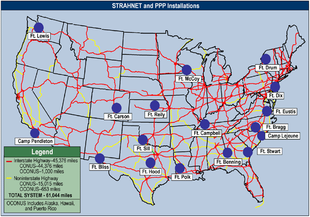
Figure A-1. U.S. Military Power Projection Platforms and the Strategic Highway Network