| <<Previous | Contents | Next >> |
Road Weather Information System
|
||||||||||||||||||||||||||||||||||||||||||||||||||||||||||||||||||||||||||||||||||||||||||||||||||||||||||||||||||||||||||||||||||||||||||||||||||||||||
|
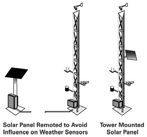
Figure 9. Options for Mounting Solar Panels |
Cost becomes a factor in deciding whether to install less expensive sensors or communications requiring little power versus more capable sensors or communications requiring more power. Efforts should be made to ensure power considerations do not jeopardize the usefulness of the ESS. The use of solar power is more common in the western and southwestern United States where there is more ample sunlight. Commercial power, requiring less maintenance but considerably more installation costs, is used in most other areas. The use of wind power has been successfully implemented for a number of ESS installations in North Dakota.
Similarly, tradeoffs in the method and equipment to support timely and effective data communications (e.g., report frequency versus cost) may also have to be made, hopefully without compromising the usefulness of the ESS.
Communications options include hardwired telephone, cellular, copper wire, fiber optic cable, wireless, radio, microwave, or satellite. Important factors in the selection of the communication method and equipment include the amount of data that will be required to pass from the RPU. This will be a function of how much data are included in each observation (e.g., bandwidth considerations) and how often observations are transmitted (e.g., report frequency). For sites with low bandwidth requirements (i.e., no video camera and infrequent reporting), a polling system using telephone lines or some type of wireless communication may be more economical than hardwired options. In some cases, ESS siting decisions will be affected by line-of-sight and terrain shadowing considerations. For high data volumes, a hardwired communication system (wire or optical fiber) appears more appropriate, although installation costs could be increased considerably. DOTs should consider using “historical” polling of road weather data, if the RWIS RPU can support it. With historical polling, road weather data are stored in the RPU and are retrieved at set times (e.g., at the top of the hour and every 15 minutes thereafter). This process differs from polling the RPU to get only the current road weather observation. Employing historical polling enables the DOT to recover earlier road weather observations if communications’ failures interrupt the polling process.
A complete analysis of communication options and possible interfaces with the present or planned ITS should be performed early in the siting process. In some cases, ESSs can be located near other ITS devices (e.g., traffic counters, dynamic message signs, traffic signal controllers) to share power and communications costs. For critical sites, backup sources of power or communications may be needed. An analysis of communications should also consider the weather information requirements of partnering agencies, such as NWS. Partnering agencies may need weather observations at a greater reporting frequency than the DOT. Such requirements may influence the communications solution.
In some cases, ESSs have been moved or painted in order to minimize how much they stand out from the surrounding terrain and vegetation. Unfortunately, following the siting criteria related to maintaining adequate distances from obstructions can result in a sensor tower that is very obvious. Pre-siting discussions with the surrounding stakeholders can possibly forestall any aesthetics problems.
Siting too close or too far from the roadway may seriously complicate maintenance procedures or unnecessarily jeopardize maintenance personnel safety. Installations too close to the pavement may make the data more representative of the actual roadway conditions but increase the hazard to maintenance personnel. Installations too far from the roadway may decrease the value of the data by making the data unrepresentative of the roadway environment. Extra security measures should be taken in areas where the threat of vandalism is present. These may include a security fence around the ESS, anti-climb panels, or even security cameras.
An important consideration of any ESS is the periodic reevaluation of the site. Over the years, construction projects, both on and off the roadway, and vegetation growth can change the representativeness and usefulness of ESS locations. A periodic reevaluation of the site is needed to ensure that the observation data from the site are still valid and that the metadata on the site are still correct. Obstructions should be reevaluated for interference and, if required, a new site should be determined or obstructions removed. Any changes resulting from this reevaluation should be included in updated entries to the site and sensor metadata in order to maintain a valid history of the site and its sensors. This reevaluation can be accomplished as part of an annual preventive maintenance program needed for sensor maintenance and calibration.
An important aspect of the effective use of road weather data from ESSs is the documentation and distribution of the site’s metadata. Metadata are basically defined as “data about data.” In the case of the RWIS ESS, metadata should include the station and sensor locations, the history of any changes in the metadata, and a representative index for the particular location and its sensors. The metadata are used to document the characteristics of each sensor and its siting to provide users a better understanding of what the sensor data really represent. The Federal Geographic Data Committee (FGDC) has developed standards for digital geospatial metadata.17 The referenced document provides “a common set of terminology and definitions for the documentation of digital geospatial data.” A companion document18 describes how and why a uniform set of criteria or standard was developed and presents it in more detail. David Hart and Hugh Phillips also have published a primer on metadata use.19 Currently, there are no corresponding uniform recommendations for RWIS ESS location and sensor metadata.
Various forms of metadata currently exist for ESSs that are not components of RWIS. The National Climatic Data Center (NCDC) maintains metadata for a number of its datasets. These datasets include: (1) Climate Reference Network dataset,20 (2) NCDC Station History Database with approximately 30,000 stations and part of the NCDC Station History Information Processing System (SHIPS),21 and (3) NWS Cooperative dataset.22 The elements for the NCDC station metadata accessible through their Master Station History Report include station identification with a number of identifiers; location (e.g., country and state); latitude/longitude; station name; period of record; elevation; and station type. Elements for the cooperative sites include exposure, topography, and driving directions. The SHIPS database also contains more detailed information about the observations and instrumentation for some locations. In addition, development of a common set of metadata requirements for the NWS National Cooperative Mesonet, a part of the NWS Integrated Surface Observing System (ISOS) Program, is currently underway. The ISOS program may include RWIS as part of the national mesonet. To be included, RWIS data will need to have a minimum set of metadata for each site. Although still being finalized, this metadata set includes platform owner, station name and identifier, station coordinates, station elevation, observed elements with their units, station reporting frequency, and an observation timestamp description. All of these metadata items are included in the recommended ESS metadata set listed in Table 2. As metadata requirements become finalized for the NWS ISOS Program, RWIS metadata managers may want to adjust their metadata archive accordingly.
Currently, procedures for archiving ESS metadata vary from state to state. To maximize the application of ESS data within the transportation community and by other potential users, uniformity in metadata content and formats is encouraged. At a minimum, those items with a history of changes should be collected, centrally stored, and backed up whenever a change occurs. In addition to the collection and storage of the metadata, the metadata should also be readily available to any individual or agency that uses the data. The effective distribution of metadata is just as important as the distribution of the sensor data. This distribution of metadata is necessary to ensure that the user understands the characteristics of the road weather data, e.g., whether it is designed to monitor the conditions at a specific site for a specific local purpose or whether that data is designed for general surface transportation weather observing and forecasting.
Recommended metadata items for ESSs are listed in Table 2. Additional metadata items, listed in Table 3, can provide more useful information to road weather data users. Some items in the metadata sets in Tables 2 and 3 correspond directly to identification objects listed in the National Transportation Communications for ITS Protocol (NTCIP) Standard for ESS objects.23
| Metadata Item | Metadata Description | Format |
|---|---|---|
Recommended Site Information |
||
| Name and/or Numbers | Name and/or numbers that uniquely describe the site. These may include WMO/International Civil Aviation Organization or NWS climate station identifiers. | Text |
| Geopolitical Placement | For example: the city, county, state, country. | Text |
| Location | Usually in latitudinal and longitudinal coordinates in decimal fractions of degrees. | Real Number |
| Elevation | Elevation above mean sea level (feet). | Integer |
| Effective Date | The date this metadata first becomes valid. | Date |
| Site Description | Textual description of the site. It may include environmental, topographic, soil and/or vegetation information. Include description of relationship of site to roadway surface (e.g., distance from/height above or below). | Text |
| Platform Owner | Contact Information. | Text |
| Involved Parties | Contact information of those who maintain the site, its data, and its metadata. | Text |
| Exposure | Description of the exposure of the site in terms of obstructions to wind and sun and artificial temperature/ moisture sources. | Text |
| Exposure Indicator | An indicator of quality of the exposure of the site. (This indicator is not yet developed. Room in the metadata should be planned for this indicator for digitally assessing the usefulness of the data for other purposes. Similar to work developed by Michel Leroy, Meteorological Measurement Representativity, Nearby Obstacles Influence).24 | Integer |
| Location Digital Panoramic Photos and Drawings | Photos and graphic drawings that display the exposure, surrounding environment. May include aerial photography or topographic analysis. | Digital Image |
| Height of base of tower to mean level of surrounding land | The elevation of the base of the tower minus the elevation of the land surrounding the location of the ESS out to approximately 300 feet. The elevation difference indicates whether the ESS is sited in the ditch or on a rise. | Integer |
| Station Reporting Frequency | Frequency at which observations are disseminated. | Text |
| Data Observing and Dissemination Practices | Description of observation and dissemination practices used at this site. | Text |
| Description of Observation Timestamps | Universal Time Coordinate or Local Time plus Daylight Savings Time information. | Text |
Recommended Sensor Information (For each sensor at this site) |
||
| Description | Element(s) sensed and units of measurement | Text |
| Sensor Type and Model Number | Short description of what type of sensor this is (e.g., thermometer, wind vane). | Text |
| Manufacturer | Who built the sensor. | Text |
| Location (if different from tower) | Usually in latitudinal and longitudinal coordinates in decimal fractions of degrees. | Real Number |
| Relation of sensor to roadway | Include description of relationship of sensor to roadway surface (e.g., distance from/height above or below, position on roadway). | Text |
| Height or depth | Height or depth of the sensor from base of tower. | Integer |
| Exposure (if different from site exposure) | Description of the exposure of the sensor in terms of obstructions to wind and sun and artificial temperature/moisture sources. | Text |
| Exposure Indicator (if different from site exposure indicator) | An indicator of quality of the exposure of the sensor. (This indicator is not yet developed. Room in the metadata should be planned for this indicator for digitally assessing the usefulness of the data for other purposes. Similar to work developed by Michel Leroy, Meteorological Measurement Representativity, Nearby Obstacles Influence) | Integer |
| Accuracy | Design accuracy of the sensor. | Text |
| Resolution | Resolution of the sensor. | Text |
| Measurement Range | Measurement range for the sensor. | Text |
| Sampling Time/Interval | Sampling Time and/or interval of the sensor data. | Text |
| Metadata Item | Metadata Description | Format |
|---|---|---|
Supplemental Site Information |
||
| Site Category | If site is part of bigger network, used to discriminate between categories/type of sites (e.g., full/partial, permanent/transportable/mobile/other). | Integer |
| Usage Category | Indicator to describe the primary use for this site (e.g., monitoring/detection/forecast). | Integer |
| Data Inventory | Description of what data originate at this site. | Text |
| Data Storage Practices | Description of where data are stored and how to access it. | Text |
| Nearby Stations | List of stations that can be used as backup for this site. | Text |
Supplemental Sensor Information (For each sensor at this site) |
||
| Level of Quality Control/ Maintenance/Calibration/Validation |
Description of quality control, maintenance, calibration, and/or validation procedures or specifications (e.g., Mean Time Between Failure). | Text |
| Algorithms used | Algorithms used to create derived data. | Text |
| Hardware/software version | Name and version of hardware/software used by this sensor. | Text |
| Date of Installation | Date of sensor installation. | Date |
| Date of Purchase | Date of sensor purchase. | Date |
Supplemental Sensor Information for Specific Sensor Types |
||
| Temperature/Relative Humidity - Ventilation Type | Type of ventilation used in the temperature/moisture sensors (e.g., fan/none). | Text |
| Temperature/Relative Humidity - Soil and Vegetation Types | Types of soil and vegetation under the temperature/moisture sensors. | Text |
| Wind - Dimensions of supporting building if any | Dimensions of supporting building. | Text |
| Wind - roughness class in four directions | Roughness class in four directions | Text |
| Radiation - horizon sketch | Sketch of the angle of the horizon in all directions | Digital Image |
By establishing, maintaining, and sharing a robust metadata archive for ESS sites and their sensors, both transportation and other users will be able to effectively apply the ESS data to their particular weather and road weather information requirements.
17 Federal Geographic Data Committee, Content Standard for Digital Geospatial Metadata, FGDC-STD-001-1998. 
18 Federal Geographic Data Committee, Content Standard for Digital Geospatial Metadata Workbook, Version 2.0, May 1, 2000.
19 Hart, D and H. Phillips, Metadata Primer—A "How To" Guide on Metadata Implementation, University of Wisconsin website.
20 US Department of Commerce, National Climatic Data Center, United States Climate Reference Network (USCRN) Metadata Management - Survey to Operations (Draft). June 2003.
21 US Department of Commerce, National Climatic Data Center, Data Documentation for Data Set 9767B, Master Station History Report. December 31, 2002.
22 Viront-Lazar, A. and P. Seurer, Metadata for Climate Data, A Geographic Data Base Model for Station History, First IEEE Metadata Conference, April 16-18, 1996.
23 US Department of Transportation. National Transportation Communications for ITS Protocol (NTCIP) - Object Definitions for Environmental Sensor Stations NTCIP 1204. November 23, 2001. Release of Version 2 is expected in 2005.
24 Leroy, M. Meteorological Measurement Representativity, Nearby Obstacles Influence, 10th Symposium on Meteorological Observations and Instrumentation, American Meteorological Society, January 11-16, 1998.
| <<Previous | Contents | Next >> |