National Highway Freight Network Map and Tables for Wisconsin, 2022

High-Resolution Images
- JPG 2.9MB
Table of National Highway Freight Network Routes, 2022
State |
Route No/ Facility Name |
Start Point |
End Point |
Route/Facility Description |
Length (Miles) |
|---|---|---|---|---|---|
WI |
I43 |
I90 |
I894 |
I43 from I90 to I894 |
60.63 |
WI |
I43 |
I41 |
Pioneer Rd |
I43 from I41 to Pioneer Rd |
23.02 |
WI |
I90 |
I94 |
I39 |
I90 from I94 to I39 |
63.20 |
WI |
I39 |
I90 |
IL/WI Line |
I39 from I90 to IL/WI Line |
78.70 |
WI |
I94 |
I43 |
I90 |
I94 from I43 to I90 |
103.04 |
WI |
I94 |
I90 |
WI/MN Line |
I94 from I90 to WI/MN Line |
148.36 |
WI |
S 43rd St |
S59 |
Oklahoma Ave |
S 43rd St from S59 to Oklahoma Ave |
2.25 |
WI |
S172 |
I41 |
Webster Ave |
S172 from I41 to Webster Ave |
2.87 |
WI |
S441 |
U41 |
Racine St |
S441 from U41 to Racine St |
1.37 |
WI |
S175/ Brewers Blvd |
S59 |
I94 |
S175/ Brewers Blvd from S59 to I94 |
0.87 |
WI |
U14 |
S Gammon Rd |
U151 |
U14 from S Gammon Rd to U151 |
3.20 |
WI |
U151 |
U14 |
U18 |
U151 from U14 to U18 |
2.72 |
WI |
U18 |
U151 |
I90 |
U18 from U151 to I90 |
6.12 |
WI |
I41 |
IL/WI Line |
I43 |
I41 from IL/WI Line to I43 |
142.11 |
WI |
WI10P - Port of Milwaukee #3 |
I94 |
Port of Milwaukee #3 |
Becher St between S 5th St and E Bay St. E Bay St between Becher Ave and S Lenox St. E Lincoln Viaduct between S Lenox St and Lincoln Memorial Dr |
1.42 |
WI |
WI11P - Port of Green Bay #1 |
WI12P |
Port of Green Bay #1 |
Hurlbut St, Bylsby Ave and Atkinson Dr between I-43 and the Port Facility |
1.42 |
WI |
WI12P - Port of Green Bay #2 |
WI13P |
Port of Green Bay #2 |
Bylsby Ave, Prairie Ave, Broadway Ave, Alexander Ave, Alexander St, Mather St, James St, McDonald St between I-43 & Port Facility |
2.21 |
WI |
WI13P - Port of Green Bay #3 |
S172 |
Port of Green Bay #3 |
Broadway Av, State St, 7th St, Motor St, 9th St, Lombardi Ave, Ashland Ave between SR 172 and the Port Facility |
4.32 |
WI |
WI3A - General Mitchell Airport, Milwaukee |
I94 |
General Mitchell Airport, Milwaukee |
Mitchell Field Main Access Rd. between Howell Av. (SR 38) and Terminal - Ext. of NHS Route |
2.92 |
WI |
WI8P - Port of Milwaukee #1 |
WI10P |
Port of Milwaukee #1 |
Lincoln Memorial Dr between Carferry Dr and E Scott St. Carferry Dr between Lincoln Memorial Dr and the Dead End. Bay St between Lincoln Memorial Dr and South Harbor Dr |
2.61 |
WI |
WI9P - Port of Milwaukee #2 |
WI10P |
Port of Milwaukee #2 |
Harbor Dr between Bay St and E Scott Dr. E Scott Dr between Lincoln Memorial Dr and Harbor Dr |
1.03 |
PHFS Total |
|
|
|
|
654.42 |
State |
Route No/ Facility Name |
Start Point |
End Point |
Route/Facility Description |
Length (Miles) |
|---|---|---|---|---|---|
WI |
I39 |
I90 |
S29 |
I39 from I90 to S29 |
103.47 |
WI |
I43 |
Pioneer Rd (End of PHFS I43) |
I41 |
I43 from Pioneer Rd (End of PHFS I43) to I41 |
102.19 |
WI |
I535 |
U53 |
WI/MN Line |
I535 from U53 to WI/MN Line |
1.09 |
WI |
I794 |
I94 |
Carferry Dr |
I794 from I94 to Carferry Dr |
3.52 |
WI |
I90 |
MN/WI Line |
I94 West |
I90 from MN/WI Line to I94 West |
46.00 |
INTERSTATE NON-PHFS Total |
|
|
|
|
256.26 |
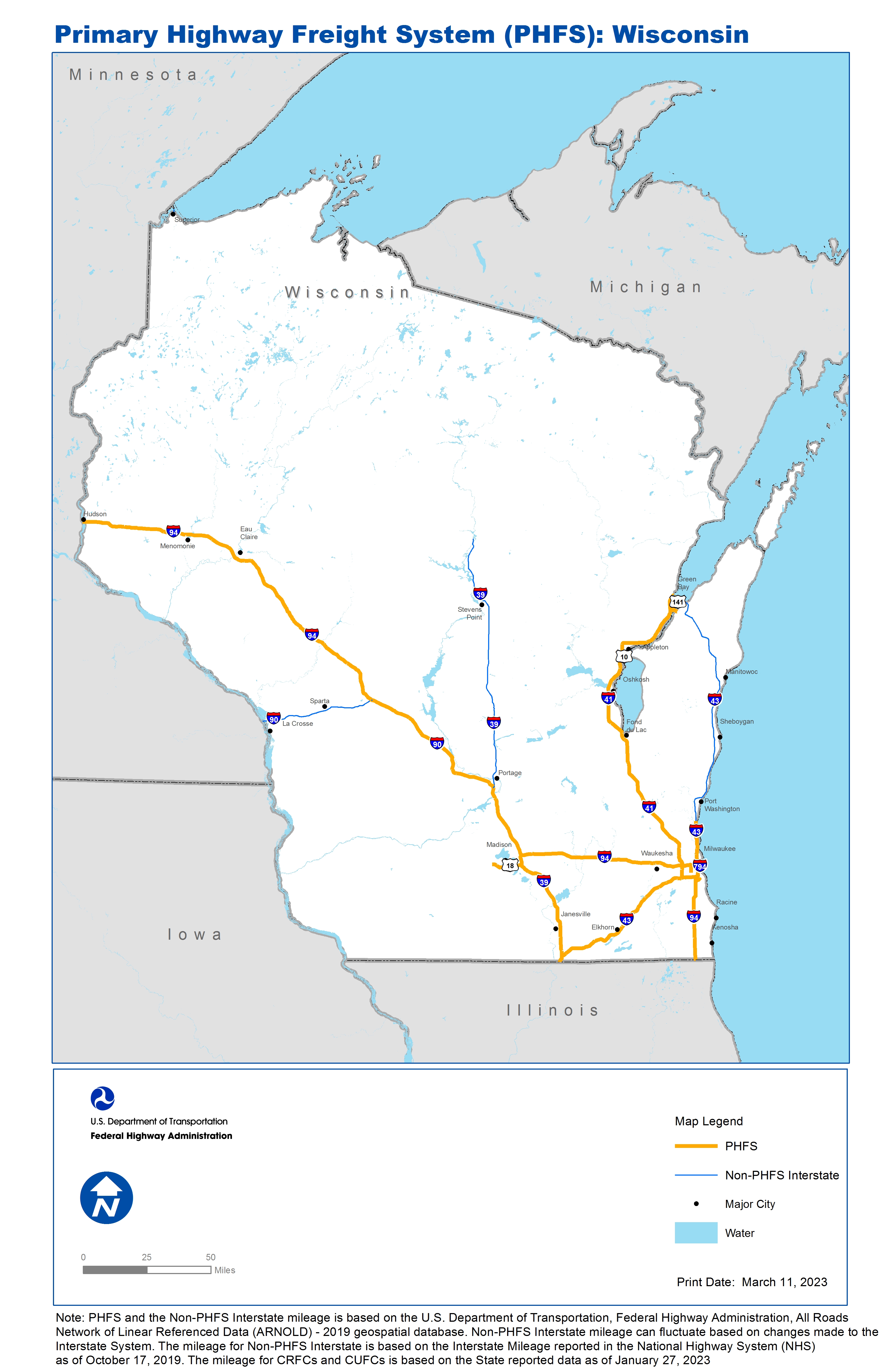
Note: PHFS and the Non-PHFS Interstate mileage is based on the U.S. Department of Transportation, Federal Highway Administration, All Roads Network of Linear Referenced Data (ARNOLD) - 2019 geospatial database. Non-PHFS Interstate mileage can fluctuate based on changes made to the Interstate System. The mileage for Non-PHFS Interstate is based on the Interstate Mileage reported in the National Highway System (NHS) as of October 17, 2019. The mileage for CRFCs and CUFCs is based on the State reported data as of January 27, 2023
Sources
U.S. Department of Transportation, Federal Highway Administration, All Roads Network of Linear Referenced Data (ARNOLD) 2019.