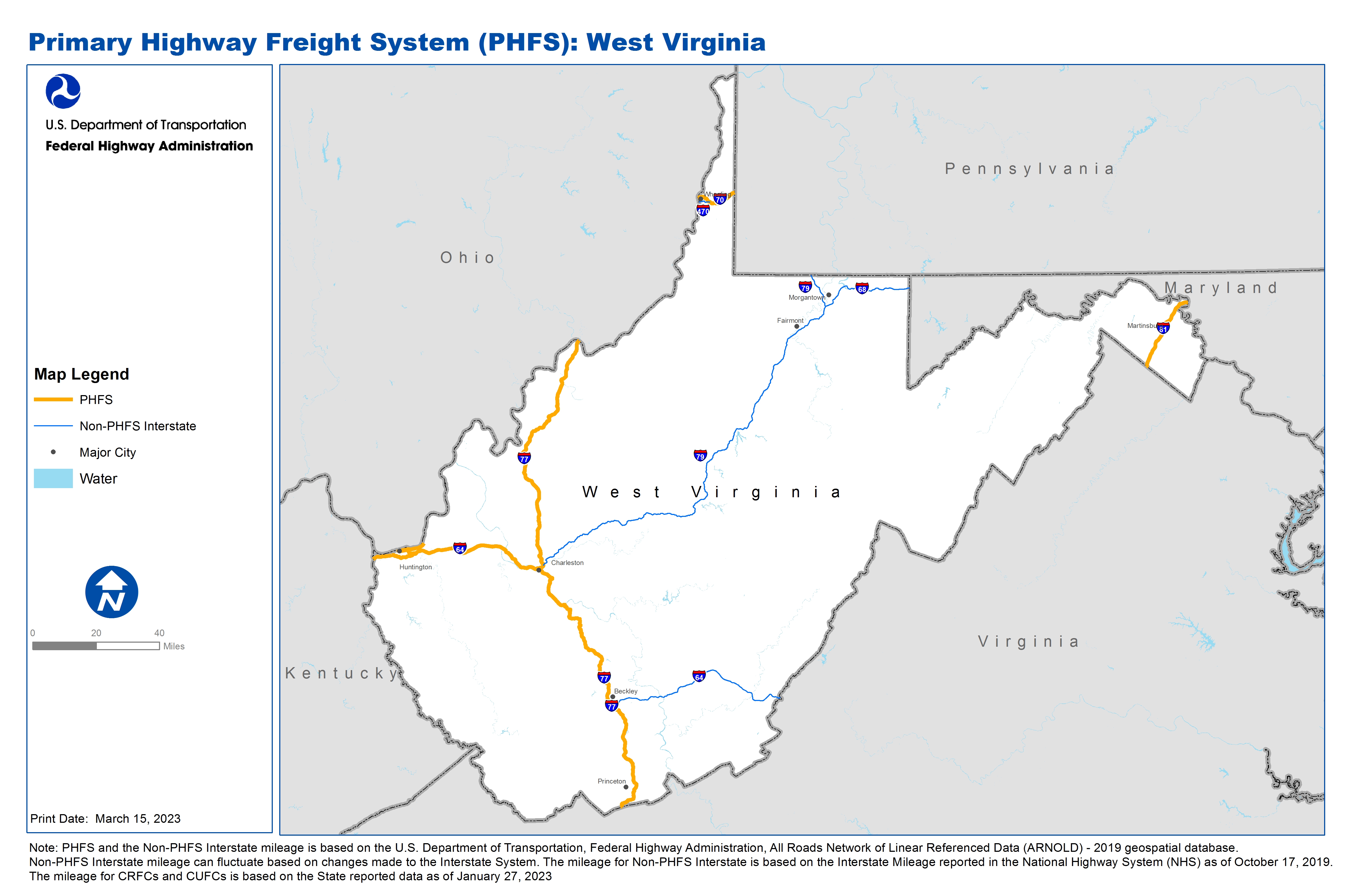
National Highway Freight Network Map and Tables for West Virginia, 2022

High-Resolution Images
- JPG 2.5MB
Table of Final Primary Freight Network Routes, 2022
State |
Route No/ Facility Name |
Start Point |
End Point |
Route/Facility Description |
Length (Miles) |
|---|---|---|---|---|---|
WV |
I64 |
KY/WV Line |
I77 |
I64 from KY/WV Line to I77 |
58.69 |
WV |
I70 |
OH/WV Line |
WV/PA Line |
I70 from OH/WV Line to WV/PA Line |
14.20 |
WV |
I77 |
VA/WV Line |
WV/OH Line |
I77 from VA/WV Line to WV/OH Line |
187.11 |
WV |
I81 |
VA/WV Line |
WV/MD Line |
I81 from VA/WV Line to WV/MD Line |
25.99 |
WV |
WV6P |
WV8P |
Cluster of Downtown Huntington Ports |
Bridge to West Virginia (OH State line to US 60 EB), US 60 EB (WV 527 to 8th), WV 527 (US 60 EB to WV 152), WV 527 NB (US 60 EB to WV 527), WV 152 (I-64 to WV 527) |
6.25 |
WV |
WV8P |
I64 |
Cluster of Ports E of Huntington on West Virginia |
From I-64 (ex 15): W and N 3.6 mi on U.S. 60, E 6.0 mi on WV 2 to port |
9.13 |
PHFS Total |
|
|
|
|
301.38 |
State |
Route No/ Facility Name |
Start Point |
End Point |
Route/Facility Description |
Length (Miles) |
|---|---|---|---|---|---|
WV |
I470 |
OH/WV Line |
I70 |
I470 from OH/WV Line to I70 |
3.83 |
WV |
I64 |
I77 |
WV/VA Line |
I64 from I77 to WV/VA Line |
63.95 |
WV |
I68 |
I79 |
WV/MD Line |
I68 from I79 to WV/MD Line |
31.95 |
WV |
I79 |
I77 |
WV/PA Line |
I79 from I77 to WV/PA Line |
159.84 |
INTERSTATE NON-PHFS Total |
|
|
|
|
259.56 |
Note: PHFS and the Non-PHFS Interstate mileage is based on the U.S. Department of Transportation, Federal Highway Administration, All Roads Network of Linear Referenced Data (ARNOLD) - 2019 geospatial database. Non-PHFS Interstate mileage can fluctuate based on changes made to the Interstate System. The mileage for Non-PHFS Interstate is based on the Interstate Mileage reported in the National Highway System (NHS) as of October 17, 2019. The mileage for CRFCs and CUFCs is based on the State reported data as of January 27, 2023
Sources
U.S. Department of Transportation, Federal Highway Administration, All Roads Network of Linear Referenced Data (ARNOLD) 2019.