National Highway Freight Network Map and Tables for Washington, 2022
High-Resolution Images
- JPG 2.9MB
Table of National Highway Freight Network Routes, 2022
State |
Route No/ Facility Name |
Start Point |
End Point |
Route/Facility Description |
Length (Miles) |
|---|---|---|---|---|---|
WA |
Boeing Access Rd |
WA64R |
I5 |
Boeing Access Rd from WA64R to I5 |
0.25 |
WA |
Garfield St |
S9 |
Sumas Ave |
Garfield St from S9 to Sumas Ave |
0.07 |
WA |
Sumas Ave |
Garfield St |
WA/BC Line |
Sumas Ave from Garfield St to WA/BC Line |
0.16 |
WA |
Spokane St S |
S99 |
I5 |
Spokane St S from S99 to I5 |
1.13 |
WA |
I205 |
OR/VA Line |
I5 |
I205 from OR/VA Line to I5 |
10.59 |
WA |
I405 |
I5 |
I5 |
I405 from I5 to I5 |
30.25 |
WA |
I5 |
OR/WA Line |
S15 |
I5 from OR/WA Line to S15 |
275.13 |
WA |
I82 |
OR/WA Line |
I90 |
I82 from OR/WA Line to I90 |
132.54 |
WA |
I90 |
I5 |
WA/ID Line |
I90 from I5 to WA/ID Line |
296.84 |
WA |
S543 |
I5 |
WA/BC Line |
S543 from I5 to WA/BC Line |
1.05 |
WA |
S167 |
S512 |
I405 |
S167 from S512 to I405 |
20.35 |
WA |
S18 |
I5 |
Auburn Way S |
S18 from I5 to Auburn Way S |
4.15 |
WA |
S512 |
I5 |
Canyon Rd |
S512 from I5 to Canyon Rd |
5.83 |
WA |
S518 |
WA41A |
I5 |
S518 from WA41A to I5 |
1.96 |
WA |
S539 |
I5 |
S546 |
S539 from I5 to S546 |
12.57 |
WA |
S546 |
S539 |
S9 |
S546 from S539 to S9 |
8.02 |
WA |
S9 |
S546 |
Garfield St |
S9 from S546 to Garfield St |
4.01 |
WA |
U2 |
WA3A |
I90 |
U2 from WA3A to I90 |
1.16 |
WA |
WA11P - Port of Vancouver - Port of Vancouver |
I5 |
Port of Vancouver |
SR 501 from I-5 to the Port of Vancouver (NW Lower River Rd) |
3.79 |
WA |
WA2A - Felts Field Municipal Airport, Spokane - Felts Field Municipal Airport, Spokane |
I90 |
Felts Field Municipal Airport, Spokane |
From I-90: Sprague Ave. and North on Fancher Rd to Airport |
1.66 |
WA |
WA31P - Port of Everett - Port of Everett |
I5 |
Port of Everett |
W Marine View Dr. (Port to Pacific), Pacific Av. (Marine View to I-5S) and Maple St ramps to I-5N |
2.33 |
WA |
WA38P - Elliot Bay-Florida St. Port (Seattle) - Elliot Bay-Florida St. Port (Seattle) |
E Marginal Way |
Elliot Bay-Florida St. Port (Seattle) |
16th Ave SW (Spokane St to Port), SW Spokane St (Chelan to E Marginal Way). |
2.03 |
WA |
WA3A - Spokane International Airport - Spokane International Airport |
U2 |
Spokane International Airport |
Airport Dr (US 2 to Airport) |
2.03 |
WA |
WA41A - Sea-Tac International Airport - Sea-Tac International Airport |
S518 |
Sea-Tac International Airport |
Air Cargo Road off of SR 518 to the terminal |
1.34 |
WA |
WA44P - Port of Tacoma - Port of Tacoma |
I5 |
Port of Tacoma |
Port of Tacoma Rd (I-5 to E 11th St), 54th Ave/Taylor Way (SR 99 to E 11th St), and Lincoln Ave (Milwaukee Way to Port of Tacoma Rd). |
6.41 |
WA |
WA59T - Swamp Creek Park-n-Ride (Lynnwood) - Swamp Creek Park-n-Ride (Lynnwood) |
I5 |
Swamp Creek Park-n-Ride (Lynnwood) |
From I-5 (exit 183): W on 164th St SW to 22nd Ave |
0.28 |
WA |
WA64R - BN-South Seattle Yard - BN-South Seattle Yard |
I5 |
BN-South Seattle Yard |
From Boeing Access Rd (just off I-5): North on Airport Way S to Facility Entrance at Hardy Street |
3.03 |
PHFS Total |
|
|
|
|
828.97 |
State |
Route No/ Facility Name |
Start Point |
End Point |
Route/Facility Description |
Length (Miles) |
|---|---|---|---|---|---|
WA |
I182 |
I82 |
U395 |
I182 from I82 to U395 |
15.19 |
WA |
I5 |
S15 |
WA/BC Line |
I5 from S15 to WA/BC Line |
1.40 |
WA |
I705 |
I5 |
S 11th St |
I705 from I5 to S 11th St |
1.51 |
INTERSTATE NON-PHFS Total |
|
|
|
|
18.10 |
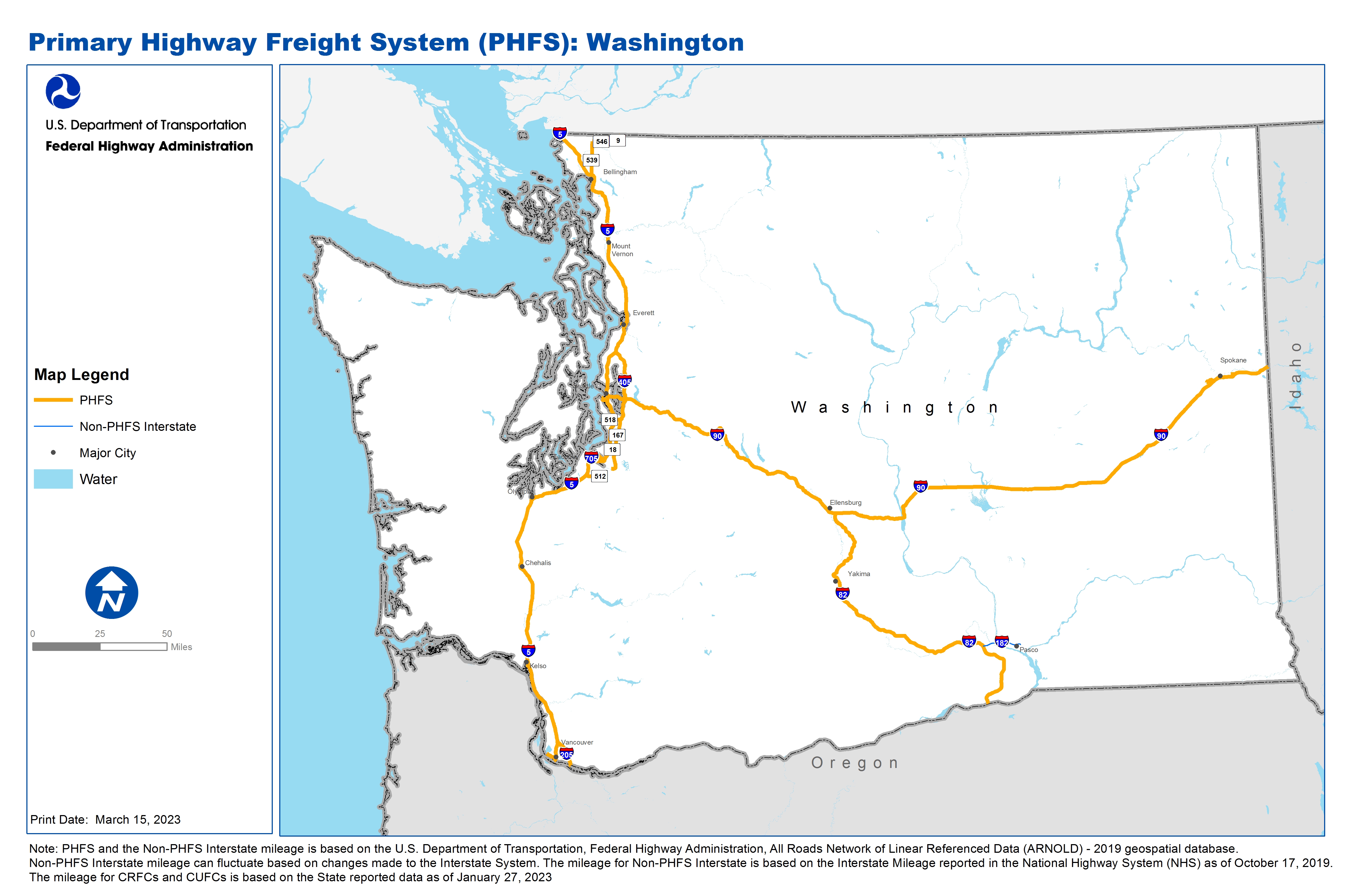
Note: PHFS and the Non-PHFS Interstate mileage is based on the U.S. Department of Transportation, Federal Highway Administration, All Roads Network of Linear Referenced Data (ARNOLD) - 2019 geospatial database. Non-PHFS Interstate mileage can fluctuate based on changes made to the Interstate System. The mileage for Non-PHFS Interstate is based on the Interstate Mileage reported in the National Highway System (NHS) as of October 17, 2019. The mileage for CRFCs and CUFCs is based on the State reported data as of January 27, 2023
Sources
U.S. Department of Transportation, Federal Highway Administration, All Roads Network of Linear Referenced Data (ARNOLD) 2019.