National Highway Freight Network Map and Tables for Texas, 2022
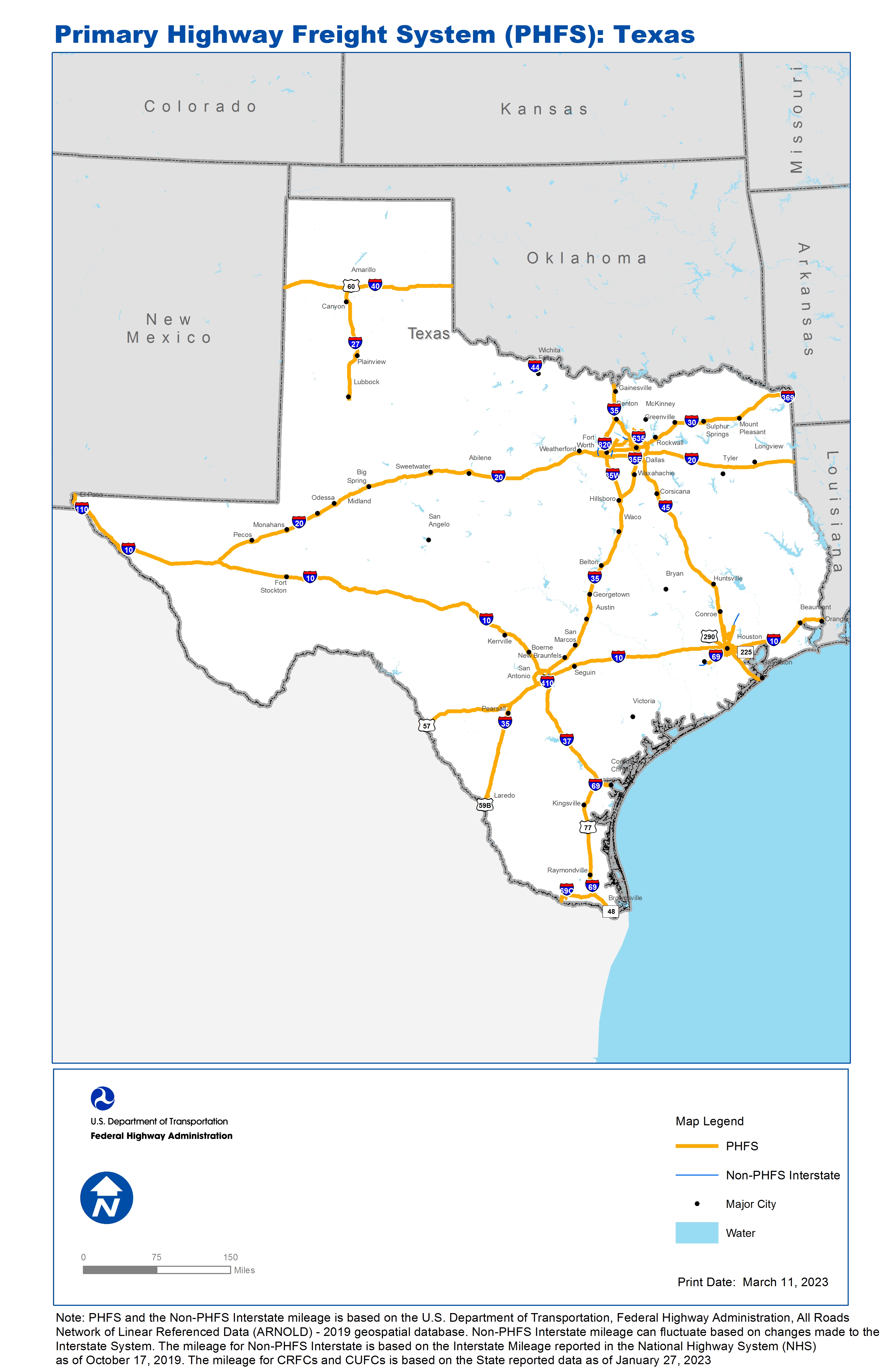
National Highway Freight Network Map: Texas
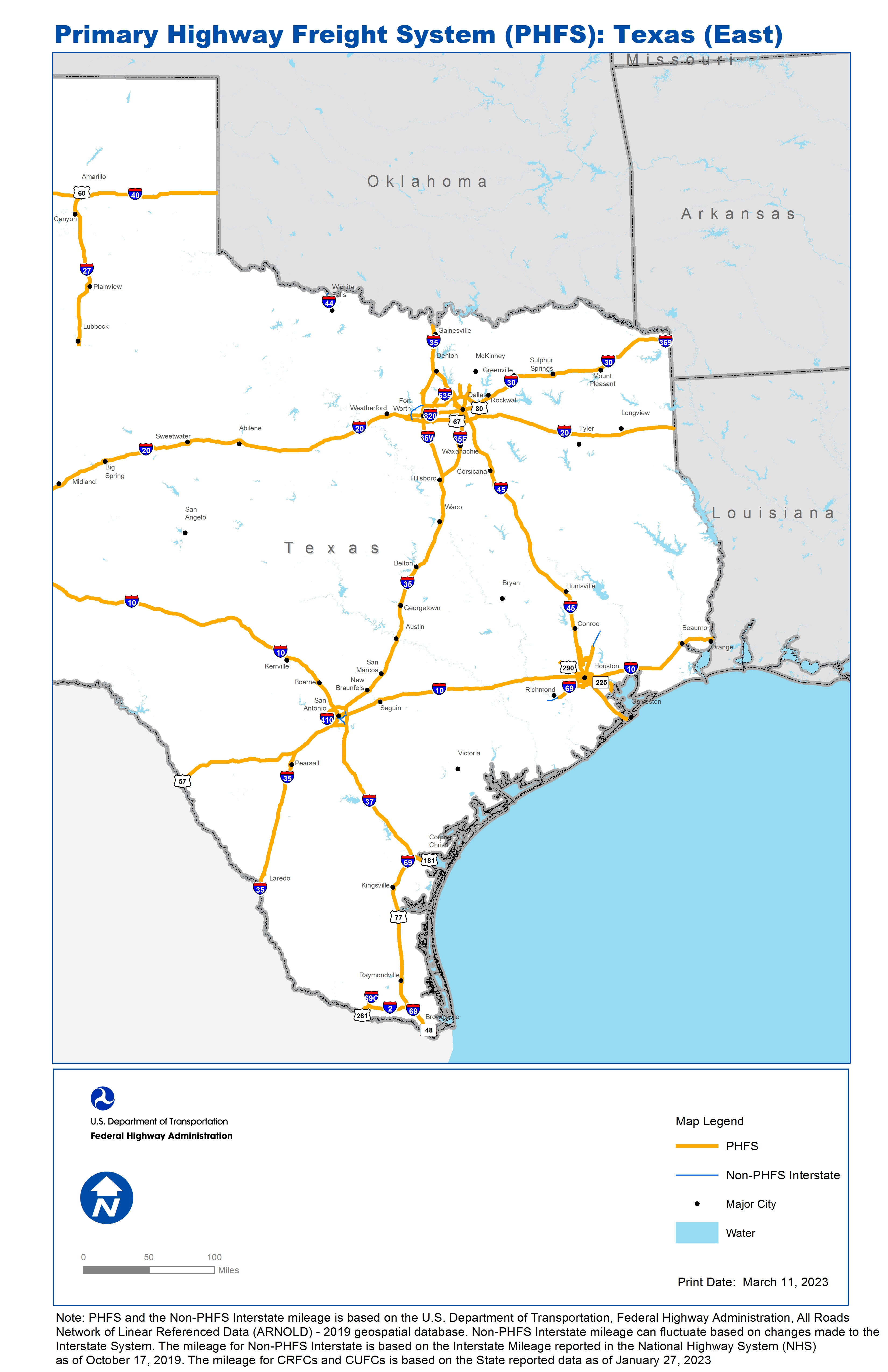
National Highway Freight Network Map: Texas (East)

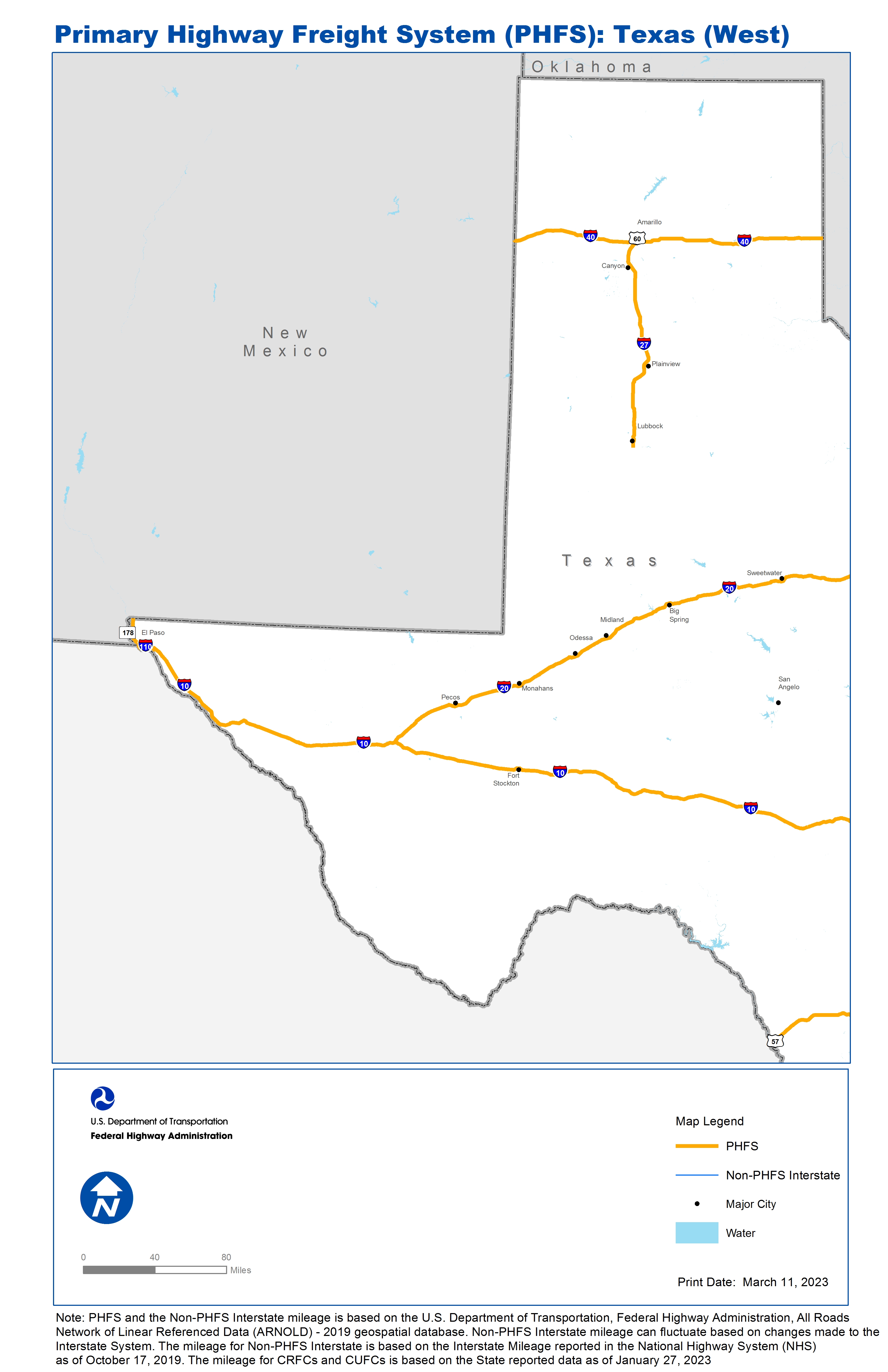
National Highway Freight Network Map: Texas (West)
High-Resolution Images
Texas
- JPEG 2.8 MB
East Texas
- JPEG 3.1 MB
West Texas
- JPEG 1.8 MB
Table of National Highway Freight Network Routes, 2022
State |
Route No/ Facility Name |
Start Point |
End Point |
Route/Facility Description |
Length (Miles) |
|---|---|---|---|---|---|
TX |
Airway Blvd |
TX44A |
I10 |
Airway Blvd from TX44A to I10 |
1.17 |
TX |
C1346 |
Pop Gunn St |
I410 |
C1346 from Pop Gunn St to I410 |
0.37 |
TX |
C526 |
TX185P |
I10 |
C526 from TX185P to I10 |
0.59 |
TX |
E 13th St |
E Elizabeth St |
Sam Perl Blvd |
E 13th St from E Elizabeth St to Sam Perl Blvd |
0.17 |
TX |
E Elizabeth St |
S4 |
E 13th St |
E Elizabeth St from S4 to E 13th St |
0.08 |
TX |
E Ridge Rd |
FM 2061 |
U281 |
E Ridge Rd from FM 2061 to U281 |
1.28 |
TX |
FM 2061/ Jackson Rd |
I2 |
E Ridge Rd |
FM 2061/ Jackson Rd from I2 to E Ridge Rd |
1.05 |
TX |
Hardy Toll Rd |
I45 |
Gulf Bank Rd |
Hardy Toll Rd from I45 to Gulf Bank Rd |
16.51 |
TX |
Hawkins Blvd |
Dodge Rd |
I10 |
Hawkins Blvd from Dodge Rd to I10 |
1.63 |
TX |
I10 |
NM/TX Line |
U90/I35 |
I10 from NM/TX Line to U90/I35 |
570.24 |
TX |
I10 |
I410 |
TX/LA Line |
I10 from I410 to TX/LA Line |
299.43 |
TX |
I110 |
I10 |
S375 |
I110 from I10 to S375 |
0.81 |
TX |
I2 |
S115 |
I69 |
I2 from S115 to I69 |
34.73 |
TX |
I20 |
I10 |
TX/LA Line |
I20 from I10 to TX/LA Line |
635.69 |
TX |
I27 |
I40 |
S289 |
I27 from I40 to S289 |
124.25 |
TX |
I30 |
I20 |
TX/AR Line |
I30 from I20 to TX/AR Line |
223.69 |
TX |
I345 |
U75 |
I30 |
I345 from U75 to I30 |
1.43 |
TX |
I35 |
U83 |
I35E and I35W |
I35 from U83 to I35E and I35W |
370.34 |
TX |
I35 |
I35E and I35W |
TX/OK Line |
I35 from I35E and I35W to TX/OK Line |
36.76 |
TX |
I35E |
I35 |
I35 |
I35E from I35 to I35 |
96.83 |
TX |
I35W |
I35 |
I35 |
I35W from I35 to I35 |
85.20 |
TX |
I37 |
U181 |
I410 |
I37 from U181 to I410 |
133.95 |
TX |
I40 |
NM/TX Line |
TX/OK Line |
I40 from NM/TX Line to TX/OK Line |
177.08 |
TX |
I410 |
I35 |
1.83 Miles West of I35 |
I410 from I35 to 1.83 Miles West of I35 |
47.22 |
TX |
I45 |
S87 |
S366 S |
I45 from S87 to S366 S |
284.75 |
TX |
I610 |
I10 |
I10 |
I610 from I10 to I10 |
38.00 |
TX |
I635 |
S161 |
I20 |
I635 from S161 to I20 |
30.52 |
TX |
I69 |
Reading Rd |
I45 |
I69 from Reading Rd to I45 |
29.07 |
TX |
I69 |
I10 |
C1314 |
I69 from I10 to C1314 |
24.80 |
TX |
I69 |
U77 |
I37 |
I69 from U77 to I37 |
7.65 |
TX |
I69 |
U77 |
S4 |
I69 from U77 to S4 |
50.19 |
TX |
I69C |
S107 |
I2 |
I69C from S107 to I2 |
6.93 |
TX |
I820 |
I30 |
I35W |
I820 from I30 to I35W |
11.35 |
TX |
N Dallas Tollway |
I635 |
Spring Creek Pkwy |
N Dallas Tollway from I635 to Spring Creek Pkwy |
9.90 |
TX |
Navigation Blvd |
TX162P |
S225 |
Navigation Blvd from TX162P to S225 |
2.18 |
TX |
Precinct Line |
S121 |
S26 |
Precinct Line from S121 to S26 |
1.15 |
TX |
S Monroe St |
U57 |
TX/MX Line |
S Monroe St from U57 to TX/MX Line |
1.14 |
TX |
S115 |
U281 S |
U83 |
S115 from U281 S to U83 |
5.95 |
TX |
S121 |
I820 |
S183 |
S121 from I820 to S183 |
5.18 |
TX |
S146 |
TX56P |
S225 |
S146 from TX56P to S225 |
5.86 |
TX |
S161 |
S183 |
I635 |
S161 from S183 to I635 |
7.11 |
TX |
S178 |
NM/TX Line |
I10 |
S178 from NM/TX Line to I10 |
3.05 |
TX |
S183 |
S121 |
S161 |
S183 from S121 to S161 |
6.39 |
TX |
S183 |
TX111L |
I35E |
S183 from TX111L to I35E |
4.17 |
TX |
S225 |
Navigation Blvd |
S146 |
S225 from Navigation Blvd to S146 |
15.32 |
TX |
S26 |
TX110L |
Precinct Line |
S26 from TX110L to Precinct Line |
5.46 |
TX |
S288 |
Airport Rd |
U59 |
S288 from Airport Rd to U59 |
6.51 |
TX |
S4 |
E Elizabeth St |
S48 |
S4 from E Elizabeth St to S48 |
4.91 |
TX |
S48 |
TX28P |
S4 |
S48 from TX28P to S4 |
3.89 |
TX |
Sam Perl Blvd |
E 13th St |
Mexico Blvd |
Sam Perl Blvd from E 13th St to Mexico Blvd |
0.55 |
TX |
U281 |
E Ridge Rd |
E Gabriella Ave |
U281 from E Ridge Rd to E Gabriella Ave |
2.78 |
TX |
U281 |
U281S/S115 |
TX/MX Line |
U281 from U281S/S115 to TX/MX Line |
1.03 |
TX |
U287 |
I20 |
Kennedale Sublett Rd |
U287 from I20 to Kennedale Sublett Rd |
2.56 |
TX |
U290 |
I610 |
Barker Cypress Rd |
U290 from I610 to Barker Cypress Rd |
17.72 |
TX |
U57 |
MX/TX Line |
I35 |
U57 from MX/TX Line to I35 |
98.03 |
TX |
U59B |
TX18A |
I35 |
U59B from TX18A to I35 |
1.84 |
TX |
U60 |
N Mirror St |
I27/ I40 |
U60 from N Mirror St to I27/ I40 |
2.80 |
TX |
U67 |
I20 |
Danieldale Rd |
U67 from I20 to Danieldale Rd |
1.97 |
TX |
U75 |
S366 S |
Spring Creek Pkwy |
U75 from S366 S to Spring Creek Pkwy |
19.87 |
TX |
U77 |
I69 |
I69 |
U77 from I69 to I69 |
90.18 |
TX |
U77 B |
U77 |
U77 |
U77 B from U77 to U77 |
0.00 |
TX |
U80 |
TX118R |
I30 |
U80 from TX118R to I30 |
0.83 |
TX |
U80 |
I635 |
S352 |
U80 from I635 to S352 |
3.69 |
TX |
U90 A |
TX167R |
U59 |
U90 A from TX167R to U59 |
2.41 |
TX |
US Rte 66 |
U60 |
0.09 Miles West of U60 |
US Rte 66 from U60 to 0.09 Miles West of U60 |
0.09 |
TX |
TX103L - GATX Terminals Corp. |
S225 |
GATX Terminals Corp. |
Jefferson (Facility to SH 225) |
1.62 |
TX |
TX105L - Star Enterprise/Texaco |
U59 |
Star Enterprise/Texaco |
Quitman between the US 59 and Stevens [0.30 mi]; Stevens between Quitman and the terminal [0.05 mi] |
0.25 |
TX |
TX108A - Alliance Airport (Dallas-Ft Worth) |
I35W |
Alliance Airport (Dallas-Ft Worth) |
Eagle Pkwy between I 35W and Old FM 156 |
1.76 |
TX |
TX110L - Diamond Shamrock Corp. Bulk Fuel Facility (DFW) |
S26 |
Diamond Shamrock Corp. Bulk Fuel Facility (DFW) |
Brumlow Ave between the Facility and SH 26 (Colleyville Blvd |
0.28 |
TX |
TX111L - Exxon Bulk Fuel Facility (DFW) |
S183 |
Exxon Bulk Fuel Facility (DFW) |
Carl Rd between the Facility and SH 183 (Airport Freeway) |
0.48 |
TX |
TX118R - Union Pacific Intermodal Facility (DFW) |
U80 |
Union Pacific Intermodal Facility (DFW) |
South Parkway between US 80 and Forney [0.040 mi]; Forney between South Parkway and Sam Houston [1.172 mi]; Sam Houston between Forney and Terminal [0.409 mi] |
0.92 |
TX |
TX120R - Santa Fe Railway Intermodal Facility (DFW) |
I35W |
Santa Fe Railway Intermodal Facility (DFW) |
Westport Road between IH 35W to Blue Mound Rd, and Intermodal Pkwy between Westport Pkwy and Blue Mound R |
4.04 |
TX |
TX12P - Port of Corpus Christi #1 |
I37 |
Port of Corpus Christi #1 |
Upriver Rd, beginning at IH-37 and FM 2292 (Morgan Mill Road) to the Citgo Plant |
6.88 |
TX |
TX13P - Port of Corpus Christi #2 |
I37 |
Port of Corpus Christi #2 |
Corn Products Rd between IH-37 and the termini at Valero |
0.68 |
TX |
TX14P - Port of Corpus Christi #3 |
I37 |
Port of Corpus Christi #3 |
Navigation Blvd between IH-37 and Chemical Turning Basin |
0.97 |
TX |
TX153A - Dallas Love Field Airport |
I35 |
Dallas Love Field Airport |
Mockingbird Ln between the Airport and I-35 |
2.73 |
TX |
TX15P - Port of Corpus Christi #4 |
I37 |
Port of Corpus Christi #4 |
Buddy Lawrence between IH-37 and the Termini at American Chrome and Chemical |
0.71 |
TX |
TX162P - Houston Barge Terminal |
U90A |
Houston Barge Terminal |
Navigation Blvd between Engle and US90A (Wayside) |
1.10 |
TX |
TX164R - UPS Sweetwater Lane Facility, Houston |
I45 |
UPS Sweetwater Lane Facility, Houston |
W Canino (IH 45 to Sweetwater Ln) [0.1 mi]; Sweetwater Ln (Terminal gate to W. Canino) [0.1 mi] |
0.25 |
TX |
TX165R - UPS Mykawa Road Facility, Houston |
I610 |
UPS Mykawa Road Facility, Houston |
Mykawa Rd (IH 610 to Wayside) |
1.36 |
TX |
TX166R - Empire Truck Lines Container Yard, Houston |
I610 |
Empire Truck Lines Container Yard, Houston |
Wallisville Rd (IH 610 to Oates) |
1.33 |
TX |
TX167R - UPS Stafford Facility, Houston |
U90 |
UPS Stafford Facility, Houston |
Stafford Rd (US 90A to Ellis) |
0.34 |
TX |
TX168P - Bulk Materials Handling Plant |
I10 |
Bulk Materials Handling Plant |
Penn City Rd (IH 10 FR to 3100 Block) |
1.71 |
TX |
TX16P - Port of Corpus Christi #5 |
I37 |
Port of Corpus Christi #5 |
Port Ave between IH-37 and US 181 the Termini at Corpus Christi Public Compress |
1.45 |
TX |
TX174P - Care Terminal, Houston |
Beltway |
Care Terminal, Houston |
Jacinto Port Blvd Between Beltway 8 to Terminal |
2.80 |
TX |
TX185P - Richardson Steel Yard |
Federal |
Richardson Steel Yard |
Industrial Blvd between Federal and the Terminal |
2.14 |
TX |
TX18A - Laredo International Airport |
U59 |
Laredo International Airport |
Bartlett St between Saunders St (US 59) and Maher Ave [0.111 mi]; Maher Ave between Bartlett St. and Pappas [0.4 mi |
0.49 |
TX |
TX21R - Port of Laredo (Union Pacific RR) |
I35 |
Port of Laredo (Union Pacific RR) |
Uniroyal (0.4 mi), Carriers (0.8 mi.), and Port Dr (1.8 mi.) to I-35 |
2.53 |
TX |
TX25R - McAllen EC Dev. Corp. & Foreign Trade Zone |
S115 |
McAllen EC Dev. Corp. & Foreign Trade Zone |
FM 1016 between Ware Rd and Spur 115 |
1.05 |
TX |
TX26A - McAllen Miller International Airport |
I2 |
McAllen Miller International Airport |
Bicentennial Blvd between Jackson Ave I2 and the Airport |
0.94 |
TX |
TX35L - Diamond Shamrock Terminal (San Antonio) |
I410 |
Diamond Shamrock Terminal (San Antonio) |
US 281 between the Terminal Entrance and I-410 |
1.36 |
TX |
TX44A - El Paso International Airport |
Airway Blvd |
El Paso International Airport |
Terminal Dr between the Airport and Airway Blvd |
0.94 |
TX |
TX50L - Chevron Refinery (El Paso) |
I10 |
Chevron Refinery (El Paso) |
Trowbridge Dr between I-10 and FM 76 |
1.82 |
TX |
TX55P - Turning Basin Terminal (S Houston) |
Navigation Blvd |
Turning Basin Terminal (S Houston) |
75th St between Navigation Blvd and the Terminal |
1.39 |
TX |
TX56P - Bayport Terminal (Houston) |
S146 |
Bayport Terminal (Houston) |
Port Rd between SH 146 and the Terminal |
0.64 |
TX |
TX57P - Jacintoport Terminal (Houston) |
I10 |
Jacintoport Terminal (Houston) |
South Sheldon Rd between I-10 and the Terminal. South Sheldon Rd between I-10 and the Terminal. . |
1.97 |
TX |
TX58P - Manchester Terminal Corp. (Houston) |
Loop 610 |
Manchester Terminal Corp. (Houston) |
Manchester between East Loop 610 and the Terminal |
0.68 |
TX |
TX70R - S.P. Houston Intermodal Hub |
I10 |
S.P. Houston Intermodal Hub |
Lockwood between I-10 and Wallisville [0.875 mi]; Wallisville between Lockwood and the Terminal [0.15 mi] |
1.10 |
TX |
TX71R - U.P. Settegast Yard (Houston) |
I610 |
U.P. Settegast Yard (Houston) |
Kirkpatrick Blvd between the Terminal and I-610 |
1.21 |
TX |
TX72R - M.P. GMAC Yard |
FM1960 |
M.P. GMAC Yard |
Hardy Rd between the Terminal and FM-1960 (Humble Westfield Rd) |
1.24 |
TX |
TX73A - Houston Intercontinental Airport |
I69 |
Houston Intercontinental Airport |
Will Clayton Pkwy from I69 to John F Kennedy Blvd to S8 |
7.10 |
PHFS Total |
|
|
|
|
3736.54 |
State |
Route No/ Facility Name |
Start Point |
End Point |
Route/Facility Description |
Length (Miles) |
|---|---|---|---|---|---|
TX |
I10 |
I35 |
I410 (East) |
I10 from I35 to I410 (East) |
8.37 |
TX |
I35 |
U83 |
U81 |
I35 from U83 to U81 |
0.14 |
TX |
I37 |
I410 (South) |
I35 |
I37 from I410 (South) to I35 |
9.20 |
TX |
I410 |
I35 |
1.83 Miles South of I35 |
I410 from I35 to 1.83 Miles South of I35 |
1.83 |
TX |
I44 |
0.08 Miles South of U277 |
TX/OK Line |
I44 from 0.08 Miles South of U277 to TX/OK Line |
15.09 |
TX |
I635 |
S161 |
S121 |
I635 from S161 to S121 |
6.45 |
TX |
I820 |
I20 (West) |
I35W (North) |
I820 from I20 (West) to I35W (North) |
17.27 |
TX |
I820 |
I30 (East) |
I20 (East) |
I820 from I30 (East) to I20 (East) |
6.82 |
TX |
I69 |
S529 |
0.22 Miles East of Williams Way Blvd |
I69 from S529 to 0.22 Miles East of Williams Way Blvd |
8.98 |
TX |
I69 |
S1314 |
0.46 Miles North of Fostoria Rd |
I69 from S1314 to 0.46 Miles North of Fostoria Rd |
13.32 |
TX |
I369 |
S93 |
I30 |
I369 from I93 to I30 |
4.02 |
INTERSTATE NON-PHFS Total |
91.49 |
Note: PHFS and the Non-PHFS Interstate mileage is based on the U.S. Department of Transportation, Federal Highway Administration, All Roads Network of Linear Referenced Data (ARNOLD) - 2019 geospatial database. Non-PHFS Interstate mileage can fluctuate based on changes made to the Interstate System. The mileage for Non-PHFS Interstate is based on the Interstate Mileage reported in the National Highway System (NHS) as of October 17, 2019. The mileage for CRFCs and CUFCs is based on the State reported data as of January 27, 2023