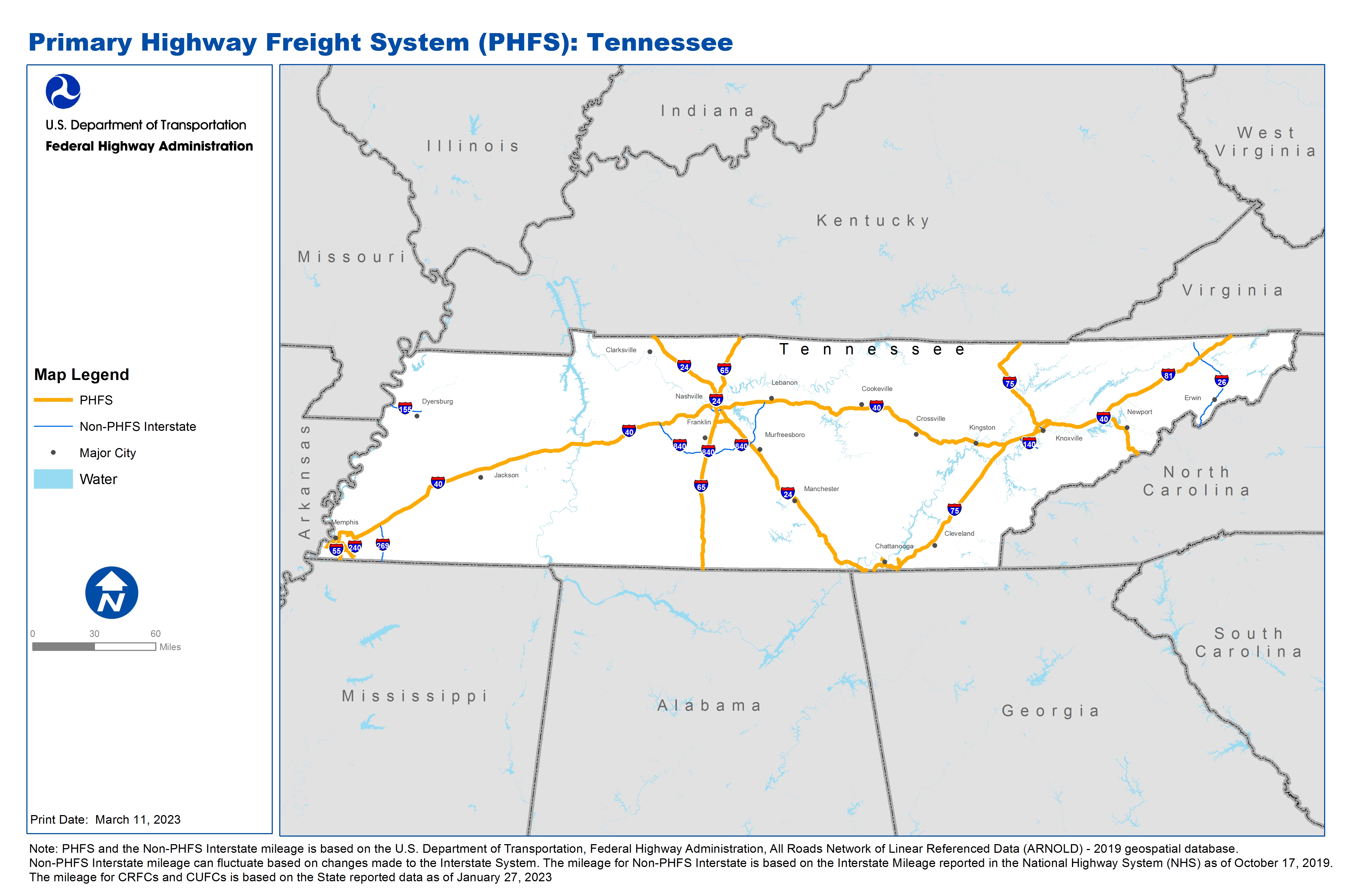
National Highway Freight Network Map and Tables for Tennessee, 2022
High-Resolution Images
- JPG 3.1MB
Table of National Highway Freight Network Routes, 2022
State |
Route No/ Facility Name |
Start Point |
End Point |
Route/Facility Description |
Length (Miles) |
|---|---|---|---|---|---|
TN |
I124 |
I24 |
S58 |
I124 from I24 to S58 |
1.70 |
TN |
I24 |
KY/TN Line |
I65 |
I24 from KY/TN Line to I65 |
44.77 |
TN |
I24 |
I65 |
TN/GA Line |
I24 from I65 to TN/GA Line |
120.17 |
TN |
I24 |
GA/TN Line |
I75 |
I24 from GA/TN Line to I75 |
14.72 |
TN |
I240 |
I40 |
I40 |
I240 from I40 to I40 |
19.30 |
TN |
I40 |
AR/TN Line |
I240 |
I40 from AR/TN Line to I240 |
14.33 |
TN |
I40 |
I240 |
I24 |
I40 from I240 to I24 |
200.41 |
TN |
I40 |
I24 |
TN/NC Line |
I40 from I24 to TN/NC Line |
239.08 |
TN |
I440 |
I40 |
U70 |
I440 from I40 to U70 |
1.51 |
TN |
I55 |
MS/TN Line |
TN/AR Line |
I55 from MS/TN Line to TN/AR Line |
12.30 |
TN |
I640 |
I75 |
I40 |
I640 from I75 to I40 |
7.05 |
TN |
I65 |
AL/TN Line |
I40 |
I65 from AL/TN Line to I40 |
82.57 |
TN |
I65 |
I40 |
TN/KY Line |
I65 from I40 to TN/KY Line |
37.43 |
TN |
I75 |
GA/TN Line |
I40 |
I75 from GA/TN Line to I40 |
84.73 |
TN |
I75 |
I40 |
TN/KY Line |
I75 from I40 to TN/KY Line |
57.46 |
TN |
I81 |
I40 |
TN/VA Line |
I81 from I40 to TN/VA Line |
75.63 |
TN |
S153 |
TN1L |
I75 |
S153 from TN1L to I75 |
3.10 |
TN |
S254 |
I65 |
I24 |
S254 from I65 to I24 |
7.45 |
TN |
S58 |
TN5P |
Chestnut St |
S58 from TN5P to Chestnut St |
0.52 |
TN |
S58 |
TN6P |
I124 |
S58 from TN6P to I124 |
0.10 |
TN |
U27 |
TN4P |
S58 |
U27 from TN4P to S58 |
0.50 |
TN |
U78/S4 |
TN18R |
TN13R |
U78/S4 from TN18R to TN13R |
8.93 |
TN |
TN11L - Colonial & Plantation Pipeline Co. - Knx |
I75 |
Colonial & Plantation Pipeline Co. - Knx |
Middlebrook Pike (Sr-169), 44th St, Western Ave from The Terminal Entrance To I-75 |
1.34 |
TN |
TN13R - Forrest Yards - Memphis Norfolk Southern |
S4 |
Forrest Yards - Memphis Norfolk Southern |
Southern Avenue from Lamar Ave. (Sr-4) to East Parkway (Sr-277). East Parkway (Sr-277) From Lamar Ave. (Sr-4) To Southern Avenue. Spottswood Avenue from Airways (Sr-277) To Forrest Yard. |
2.08 |
TN |
TN14P - President's Island - Memphis |
I55 |
President's Island - Memphis |
McLemore Ave, Riverside Blvd, Jack Carley Causeway, Harbor Av, Channel Av, Jetty St Btw I-55 & Port |
4.61 |
TN |
TN15A - Memphis International Airport |
I240 |
Memphis International Airport |
Tchulahoma And Democrat Rd Between Lamar Ave (Sr-4) And Airways Blvd. Plough Blvd Between I-240 And the Airport Entrance |
4.40 |
TN |
TN17R - Leewood Yards - Memphis Csx |
I40 |
Leewood Yards - Memphis Csx |
Jackson Avenue (Sr-14) And Chelsea Avenue Between I-40 And Warford Street |
2.72 |
TN |
TN18R - Tennessee Yards - Memphis Burlington Nor |
S4 |
Tennessee Yards - Memphis Burlington Nor |
Shelby Drive Between Lamar Avenue (Sr-4) And the Tennessee Yard |
0.75 |
TN |
TN19R - Johnston Yards - Memphis Illinois Centra |
I55 |
Johnston Yards - Memphis Illinois Centra |
Mallory Avenue and Riverport Road Between I-55 And Rail Yard |
3.05 |
TN |
TN1L - Colonial Pipeline - Chattanooga |
S153 |
Colonial Pipeline - Chattanooga |
Jersey Pike From Enterprise Park Drive to Sr-153 |
0.57 |
TN |
TN22R - Radnor Yards - Nashville Csx |
I65 |
Radnor Yards - Nashville Csx |
Armory Ave And Sidco Drive Between I-65 And Harding Place (Sr-255) |
1.99 |
TN |
TN2A - Chattanooga Metropolitan Airport |
S153 |
Chattanooga Metropolitan Airport |
Shepherd Road (Airport Connector) Between Sr-153 And Airport Road |
0.77 |
TN |
TN3P – |
TN4P |
Mid-South Terminals |
Hudson Rd. To Pineville Rd. To Moccasin Bend Rd. To Hamm Rd. To S. R. 29 |
2.36 |
TN |
TN4P - J.I.T. Terminals - Chattanooga |
S29 |
J.I.T. Terminals - Chattanooga |
Manufactures Road from Sr-29 To Terminal Entrance |
0.67 |
TN |
TN5P - Vulcan Materials Company - Chattanooga |
S58 |
Vulcan Materials Company - Chattanooga |
River Street from Evans Street to Riverfront Parkway (Sr-58) |
0.20 |
TN |
TN6P - Southern Foundry Supply - Chattanooga |
S58 |
Southern Foundry Supply - Chattanooga |
West 19th Street from Riverfront Parkway (Sr-58) To the Port Entrance |
0.32 |
PHFS Total |
|
|
|
|
1059.59 |
State |
Route No/ Facility Name |
Start Point |
End Point |
Route/Facility Description |
Length (Miles) |
|---|---|---|---|---|---|
TN |
I140 |
I40 |
U129 |
I140 from I40 to U129 |
11.19 |
TN |
I155 |
MO/TN Line |
U412 |
I155 from MO/TN Line to U412 |
15.95 |
TN |
I26 |
U11W |
NC/TN Line |
I26 from U11W to NC/TN Line |
54.42 |
TN |
I275 |
I640 |
I40 |
I275 from I640 to I40 |
2.99 |
TN |
I440 |
U70 |
I24 |
I440 from U70 to I24 |
6.13 |
TN |
I840 |
I65 |
I40 |
I840 from I65 to I40 |
45.73 |
TN |
I269 |
MS/TN Line |
Donelson Farms Pkwy |
I269 from MS/TN Line to Donelson Farms Pkwy |
18.43 |
TN |
I840 |
0.47 Miles North of I40 |
0.06 Miles East of I65 |
I840 from 0.47 Miles North of I40 to 0.06 Miles East of I65 |
31.68 |
INTERSTATE NON-PHFS Total |
186.52 |
Note: PHFS and the Non-PHFS Interstate mileage is based on the U.S. Department of Transportation, Federal Highway Administration, All Roads Network of Linear Referenced Data (ARNOLD) - 2019 geospatial database. Non-PHFS Interstate mileage can fluctuate based on changes made to the Interstate System. The mileage for Non-PHFS Interstate is based on the Interstate Mileage reported in the National Highway System (NHS) as of October 17, 2019. The mileage for CRFCs and CUFCs is based on the State reported data as of January 27, 2023