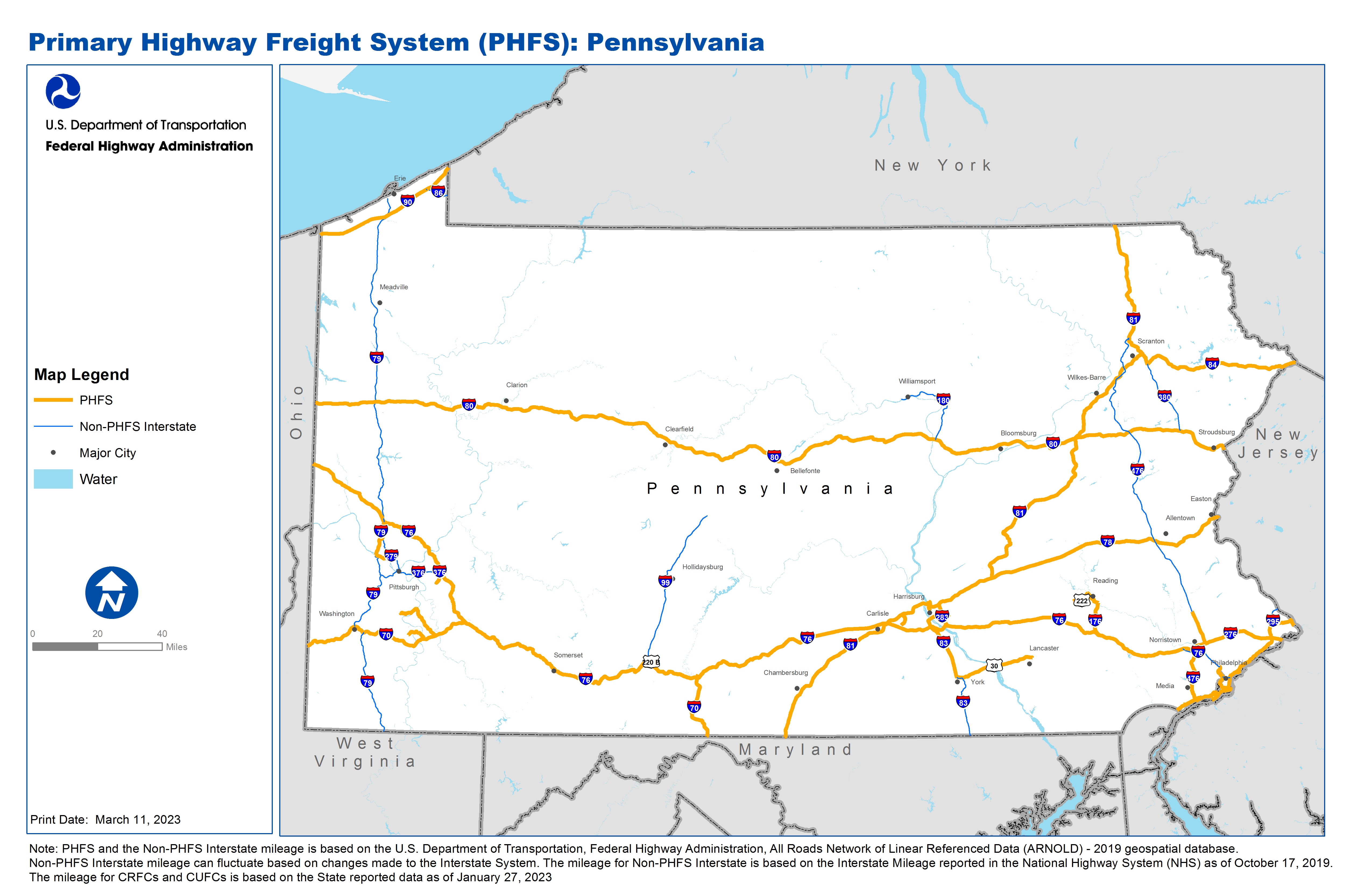
National Highway Freight Network Map and Tables for Pennsylvania, 2022

High-Resolution Images
- JPG 3.2MB
Table of National Highway Freight Network Routes, 2022
State |
Route No/ Facility Name |
Start Point |
End Point |
Route/Facility Description |
Length (Miles) |
|---|---|---|---|---|---|
PA |
Front St |
I76 |
PA33R (Pattison Av) |
Front St from I76 to PA33R (Pattison Av) |
0.44 |
PA |
I176 |
I76 |
U422 |
I176 from I76 to U422 |
10.69 |
PA |
I276 |
U422 |
PA/NJ Line |
I276 from U422 to PA/NJ Line |
32.99 |
PA |
I283 |
I76 |
U322 |
I283 from I76 to U322 |
3.21 |
PA |
I295 |
I276/I95 |
U1 |
I295 from I276/I95 to U1 |
5.39 |
PA |
I376 |
PA4R |
I76 |
I376 from PA4R to I76 |
0.58 |
PA |
I476 |
I95 |
0.58 Miles North of S63 |
I476 from I95 to 0.58 Miles North of S63 |
31.38 |
PA |
I676 |
I95 |
PA/NJ Line |
I676 from I95 to PA/NJ Line |
0.36 |
PA |
I70 |
MD/PA Line |
I76/U30 |
I70 from MD/PA Line to I76/U30 |
23.28 |
PA |
I70 |
I76 |
PA/WV Line |
I70 from I76 to PA/WV Line |
57.34 |
PA |
I76 |
NJ/PA Line |
U1 |
I76 from NJ/PA Line to U1 |
11.04 |
PA |
I76 |
U422 |
PA/OH Line |
I76 from U422 to PA/OH Line |
327.04 |
PA |
I78 |
I81 |
PA/NJ Line |
I78 from I81 to PA/NJ Line |
77.42 |
PA |
I79 |
PA2P |
I76 |
I79 from PA2P to I76 |
11.12 |
PA |
I80 |
OH/PA Line |
PA/NJ Line |
I80 from OH/PA Line to PA/NJ Line |
311.10 |
PA |
I81 |
MD/PA Line |
PA/NY Line |
I81 from MD/PA Line to PA/NY Line |
232.55 |
PA |
I83 |
U30 |
I81 |
I83 from U30 to I81 |
29.05 |
PA |
I84 |
I81 |
PA/NY Line |
I84 from I81 to PA/NY Line |
54.35 |
PA |
I90 |
OH/PA Line |
PA/NY Line |
I90 from OH/PA Line to PA/NY Line |
46.31 |
PA |
I95 |
DE/PA Line |
I276/I295 |
I95 from DE/PA Line to I276/I295 |
40.19 |
PA |
S114 |
PA41L |
I81 |
S114 from PA41L to I81 |
1.81 |
PA |
S51 |
PA5P |
I70 |
S51 from PA5P to I70 |
10.92 |
PA |
S724 |
U422 |
U222 |
S724 from U422 to U222 |
1.32 |
PA |
U1 |
I95 |
PA/NJ Line |
U1 from I95 to PA/NJ Line |
6.21 |
PA |
U22 |
PA13R |
I81 |
U22 from PA13R to I81 |
1.77 |
PA |
U222 |
S724 |
U422 |
U222 from S724 to U422 |
3.51 |
PA |
U30 |
I83 |
U222 |
U30 from I83 to U222 |
25.12 |
PA |
U322 |
PA15R |
I83/I283 |
U322 from PA15R to I83/I283 |
0.72 |
PA |
U322 |
PA36R |
I95 |
U322 from PA36R to I95 |
0.67 |
PA |
U422 |
PA10L |
S724 |
U422 from PA10L to S724 |
0.21 |
PA |
U422 |
U222 |
I176 |
U422 from U222 to I176 |
4.87 |
PA |
PA10L - Atlantic Pipeline Co. |
U422 |
Atlantic Pipeline Co. |
E on Mountain Home Rd (SR 3012) to Columbia Ave (SR 3016) or Woodrow Rd& N to US 422 |
1.38 |
PA |
PA13R - Harrisburg Lucknow Termini |
U22 |
Harrisburg Lucknow Termini |
S on Industrial Rd to Wildewood Park Dr to Cameron St; North on Industrial Rd to Linglestown Rd (SR 0039) to US 22 |
2.90 |
PA |
PA15R - Conrail DB Stack Facility and Triple Crown RDRLR |
U322 |
Conrail DB Stack Facility and Triple Crown RDRLR |
W on Grayson Rd to Rupp Hill Rd to Paxton St to Penhar Dr to US 322 |
1.90 |
PA |
PA22P - Tioga Port Facilities |
I95 |
Tioga Port Facilities |
Delaware Ave to Castor Ave to I-95; Delaware Ave to Alleghany Ave to I-95 |
1.55 |
PA |
PA28R - Norfolk Southern Morrisville |
U1 |
Norfolk Southern Morrisville |
E Cabot Blvd to Oxford Valley Rd to US 1 |
1.34 |
PA |
PA2P - Neville Island Freight Cluster |
I79 |
Neville Island Freight Cluster |
Southeast on Neville Rd to PA 51; Northwest on Neville Rd, West on Grand Ave to I-79 |
3.52 |
PA |
PA31R - CSX Eastside Bulk |
I76 |
CSX Eastside Bulk |
From I-76 along Moore St, Warfield St, Passyunk Ave and Wharton St to facility |
0.70 |
PA |
PA33R - South Philadelphia Rail Complex |
Pattison Ave |
South Philadelphia Rail Complex |
Pattison Ave from Front St to C. Columbus Blvd to Delaware Ave via Packer Ave |
0.96 |
PA |
PA34A - Philadelphia International Airport - Freight Facilities |
I95 |
Philadelphia International Airport - Freight Facilities |
North on Scott Way, Northeast on Penrose Ave (SR 0291) to I-95 NB: North on Scotts Way, Northeast on Bartram Ave to I-95 SB. East on Hog Island Ave, North on Fort Mifflin Ave to Enterprise Ave to I-95 NB; West Enterprise Ave to Island Ave to I-95 SB. . |
6.78 |
PA |
PA35P - Penn. Terminals |
I95 |
Penn. Terminals |
North on Saville Ave, East on Industrial Hwy (PA 291), North on Stewart Ave (SR 2033) to I-95 |
2.09 |
PA |
PA36R - CSX Twin Oaks Auto |
U322 |
CSX Twin Oaks Auto |
Bethel Rd to US 322 (Conchester Rd) |
0.15 |
PA |
PA40P - Novolog Port Facility |
U1 |
Novolog Port Facility |
South Pennsylvania Ave to US 1 |
1.81 |
PA |
PA41L - Petroleum Products Corporation Terminal (Silver Spring Township) |
U11 |
Petroleum Products Corporation Terminal (Silver Spring Township) |
From US 11, south on SR 114 to Texaco Road ending at Hempt Road |
2.39 |
PA |
PA4R - Conrail Double Stack Intermodal Terminal |
I376 |
Conrail Double Stack Intermodal Terminal |
SE on Wall Ave to PA 48 (SR 0048) North on PA 48 to I-376 |
4.14 |
PA |
PA5P - W Elizabeth Monongahela River Terminal Cluster |
S51 |
W Elizabeth Monongahela River Terminal Cluster |
NE on New State Hwy (SR 0837) to PA 51 (SR 0051); Southwest on New St Hwy & SR 0837 to SR 1006 to Mon/Fayette Expy |
6.23 |
PA |
PA6P - Donora industrial Park Terminal |
I70 |
Donora industrial Park Terminal |
SE on McKean Ave (SR 0837) to SR 1077 to SR 3013 to SR 0201 & connects to I-70: Southeast on McKean Ave & SR 0837 to Coyle Curtain Rd to Future M/F Expy |
7.30 |
PHFS Total |
1,408.13 |
||||
State |
Route No/ Facility Name |
Start Point |
End Point |
Route/Facility Description |
Length (Miles) |
|---|---|---|---|---|---|
PA |
I180 |
U15 |
I80 |
I180 from U15 to I80 |
28.85 |
PA |
I279 |
I376 |
I79 (North) |
I279 from I376 to I79 (North) |
13.28 |
PA |
I295 |
U1 |
PA/NJ Line |
I295 from U1 to PA/NJ Line |
5.71 |
PA |
I376 |
I279 |
PA4R |
I376 from I279 to PA4R |
20.45 |
PA |
I380 |
I80 |
I84 |
I380 from I80 to I84 |
24.05 |
PA |
I476 |
0.58 Miles North of S63 |
I81 |
I476 from 0.58 Miles North of S63 to I81 |
100.30 |
PA |
I579 |
I376 |
I279 |
I579 from I376 to I279 |
1.89 |
PA |
I676 |
I76 |
I95 |
I676 from I76 to I95 |
2.41 |
PA |
I76 |
I276 |
U1 |
I76 from I276 to U1 |
13.84 |
PA |
I79 |
WV/PA Line |
I70 (East) |
I79 from WV/PA Line to I70 (East) |
33.84 |
PA |
I79 |
I70 (West) |
PA2P (Neville Rd) |
I79 from I70 (West) to PA2P (Neville Rd) |
28.02 |
PA |
I79 |
I76 |
S5 |
I79 from I76 to S5 |
106.54 |
PA |
I83 |
MD/PA Line |
U30 |
I83 from MD/PA Line to U30 |
21.09 |
PA |
I86 |
I90 |
PA/NY Line |
I86 from I90 to PA/NY Line |
7.25 |
PA |
I99 |
I70 |
S350 |
I99 from I70 to S350 |
51.66 |
INTERSTATE NON-PHFS Total |
459.18 |
||||
Note: PHFS and the Non-PHFS Interstate mileage is based on the U.S. Department of Transportation, Federal Highway Administration, All Roads Network of Linear Referenced Data (ARNOLD) - 2019 geospatial database. Non-PHFS Interstate mileage can fluctuate based on changes made to the Interstate System. The mileage for Non-PHFS Interstate is based on the Interstate Mileage reported in the National Highway System (NHS) as of October 17, 2019. The mileage for CRFCs and CUFCs is based on the State reported data as of January 27, 2023