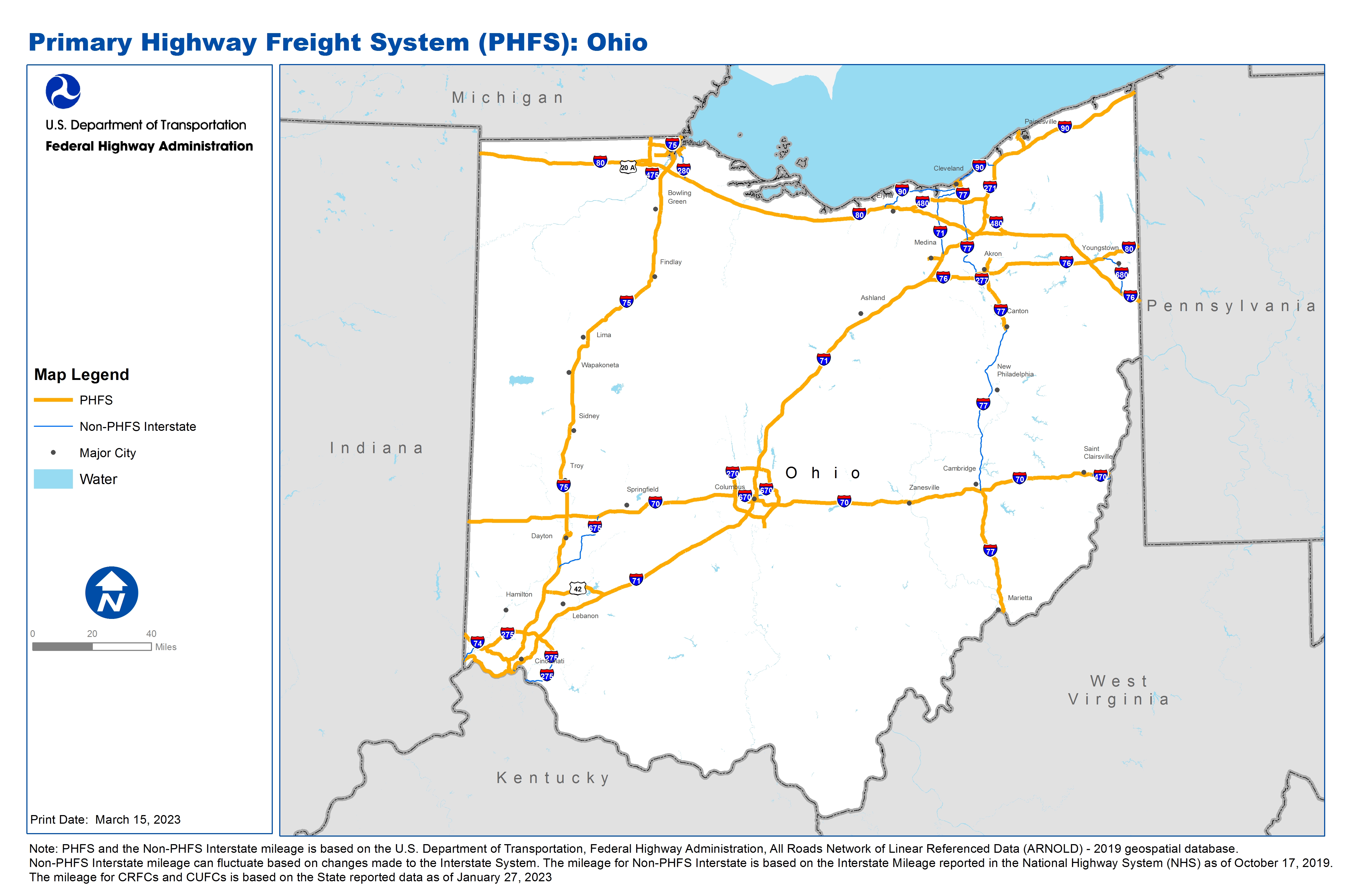
National Highway Freight Network Map and Tables for Ohio, 2022

High-Resolution Images
- JPG 2.8MB
Table of Final Primary Freight Network Routes, 2022
State |
Route No/ Facility Name |
Start Point |
End Point |
Route/Facility Description |
Length (Miles) |
|---|---|---|---|---|---|
OH |
I270 |
I70 |
I70 |
I270 from I70 to I70 |
54.92 |
OH |
I271 |
I71 |
I90 |
I271 from I71 to I90 |
40.23 |
OH |
I275 |
I74 |
S131 |
I275 from I74 to S131 |
29.99 |
OH |
I277 |
I76 |
I77 |
I277 from I76 to I77 |
3.83 |
OH |
I280 |
I75 |
S2 |
I280 from I75 to S2 |
4.12 |
OH |
I475 |
I75 |
I75 |
I475 from I75 to I75 |
20.45 |
OH |
I480 |
I80 |
I271 |
I480 from I80 to I271 |
27.02 |
OH |
I480 |
I271 |
I80 |
I480 from I271 to I80 |
9.98 |
OH |
I670 |
I71 |
1.68 Miles West of I71 |
I670 from I71 to 1.68 Miles West of I71 |
1.63 |
OH |
I70 |
IN/OH Line |
OH/WV Line |
I70 from IN/OH Line to OH/WV Line |
225.63 |
OH |
I71 |
KY/OH Line |
I70 |
I71 from KY/OH Line to I70 |
106.33 |
OH |
I71 |
I70 |
I271 |
I71 from I70 to I271 |
112.62 |
OH |
I74 |
IN/OH Line |
I75 |
I74 from IN/OH Line to I75 |
19.47 |
OH |
I75 |
KY/OH Line |
OH/MI Line |
I75 from KY/OH Line to OH/MI Line |
211.17 |
OH |
I76 |
I71 |
OH/PA Line |
I76 from I71 to OH/PA Line |
81.13 |
OH |
I77 |
WV/OH Line |
I70 |
I77 from WV/OH Line to I70 |
44.09 |
OH |
I77 |
U30 |
I277 |
I77 from U30 to I277 |
18.69 |
OH |
I77 |
I480 |
I90 |
I77 from I480 to I90 |
6.86 |
OH |
I80 |
IN/OH Line |
OH/PA Line |
I80 from IN/OH Line to OH/PA Line |
237.10 |
OH |
I90 |
I77 |
S2 |
I90 from I77 to S2 |
1.65 |
OH |
I90 |
I271 |
OH/PA Line |
I90 from I271 to OH/PA Line |
55.08 |
OH |
S18 |
OH63R |
U42 |
S18 from OH63R to U42 |
0.75 |
OH |
S18 |
U42 |
I71 |
S18 from U42 to I71 |
3.48 |
OH |
S2 |
I80 |
I475 |
S2 from I80 to I475 |
5.68 |
OH |
S2 |
OH43P |
I90 |
S2 from OH43P to I90 |
1.14 |
OH |
S2 |
S44 |
S44 |
S2 from S44 to S44 |
0.92 |
OH |
S4 |
OH25L |
I75 |
S4 from OH25L to I75 |
2.10 |
OH |
S44 |
OH39P |
S2 |
S44 from OH39P to S2 |
2.55 |
OH |
S44 |
S2 |
I90 |
S44 from S2 to I90 |
4.13 |
OH |
S8 |
I77 |
Portage Trl |
S8 from I77 to Portage Trl |
5.47 |
OH |
U23 |
I475 |
OH/MI Line |
U23 from I475 to OH/MI Line |
3.04 |
OH |
U24 |
OH3R |
I75 |
U24 from OH3R to I75 |
2.40 |
OH |
U422 |
OH56T |
OH47P/I77 |
U422 from OH56T to OH47P/I77 |
0.59 |
OH |
U6 |
OH44P |
OH56T (Ontario St) |
U6 from OH44P to OH56T (Ontario St) |
0.96 |
OH |
OH1P - Midwest Terminals General Cargo |
I280 |
Midwest Terminals General Cargo |
From I-280, Northeast on SR-65, Front St, Continue NE on Front St, Left, East on Millard Ave, Left on Tiffin Ave., to Facility Entrance |
2.78 |
OH |
OH21A - Rickenbacker International Airport |
I270 |
Rickenbacker International Airport |
Begin exit ramp from I-270, turn left, S, onto Alum Creek Dr to jct SR-317, from SR-317 continue S. on Alum Creek Dr. to Airport facility entrance |
3.75 |
OH |
OH23R - Columbus CSX |
I270 |
Columbus CSX |
Begin exit ramp from I-270, Turn left, W onto Roberts Rd to jct with Westbelt Dr, turn left, S onto Westbelt Dr to facility entrance |
2.12 |
OH |
OH25L - Pipeline Fuel Terminals |
U4 |
Pipeline Fuel Terminals |
(Entrance for Sunoco/Citgo) Begin at exit ramp from US-4, turn left, NW onto Findlay St to jct with SR-201, Brandt Pike, turn right, N onto SR- 201, Brandt Pike to facility entrance for Sunoco/Citgo, (Entrance for BP) Stanley, go SE on Stanley Ave to j |
1.24 |
OH |
OH28L - Texas Eastern & Manhattan Petro Pipeline |
I75 |
Texas Eastern & Manhattan Petro Pipeline |
Begin At I-75 exit ramp, Follow SR-122 East to facility entrance. Begin in Clinton County at I-71 exit ramp with SR-73, Travel West on SR-73 to CLI/WAR Co line, Continue West on SR-73 in Warren Co to jct with US-42, turn left, South onto US-42 to jct w |
22.61 |
OH |
OH29P - Intermodal Barge Fac. along U.S. 50 |
I75 |
Intermodal Barge Fac. along U.S. 50 |
1) Begin on I-75 ramp to US-50, Follow US-50 West along OHio River to Indiana Border (2) Begin on US-50 from Indiana Border to jct I-75. . |
20.76 |
OH |
OH30R - Cincinnati Norfolk Southern Gest Street Yard |
I75 |
Cincinnati Norfolk Southern Gest Street Yard |
Begin at I-75 ramp to US-50, US-50 W 6th St Expwy to ramp to Dalton Ave. Section already connector for OH29P, take "ramp" from US-50 to Dalton Ave, continue on Dalton Ave to jct with W 8th St, turn le |
1.15 |
OH |
OH31R - Cincinnati Norfolk Southern Queensgate |
I75 |
Cincinnati Norfolk Southern Queensgate |
From I-75 SB Ramp to Western Ave/ Liberty St Exit 2A, turn right, West onto Findlay St to jct with Dalton Ave, turn right, North, onto Dalton Ave to jct with Bank St turn left, West onto Bank St to jc. From I-75 NB ramp to Exit US-50 West, Exit 10, foll |
1.73 |
OH |
OH39P - Port of Fairport Harbor - Grand River |
S44 |
Port of Fairport Harbor - Grand River |
From SR44: E on Olive, Non Williams/Headlands to port |
1.08 |
OH |
OH3R - Norfolk Southern Junction Intermodal Yard |
U20 |
Norfolk Southern Junction Intermodal Yard |
From jct with US-20, Reynolds Rd, east on Hill Rd to jct with Parkside Blvd extension (road not currently on system) turn Right, South onto Parkside Blvd Ext. to facility entrance |
3.96 |
OH |
OH43P - Port of Cleveland - East Basin |
U20 |
Port of Cleveland - East Basin |
From U.S. 20/U.S. 6/SR 2: North on E. 9th St, West on Erieside Avenue to Port. From SR 2: West on SR 2 Marginal Roads, North on W. 3rd Street to Port. . |
0.93 |
OH |
OH44P - Port of Cleveland - West Basin |
U6 |
Port of Cleveland - West Basin |
From U.S. 6: N on W. 25th St, NE on Main Ave, NW on Elm St, N on River Rd to Port Entrance. . |
0.62 |
OH |
OH45P - Port of Cleveland -Cuyahoga River Berths |
U422 |
Port of Cleveland -Cuyahoga River Berths |
From U.S. 422 (Broadway): SW on Lorain, southerly on Commercial Ave, SW on W. 3rd St to port |
0.65 |
OH |
OH46P - Port of Cleveland-Berths & RR/truck term |
I490 |
Port of Cleveland-Berths & RR/truck term |
From I-490: south on W. 7th St, northeasterly on Quigley Ave, northwesterly on W. 3rd St to port |
1.63 |
OH |
OH47P - Port of Cleveland - Marathon Oil Co. |
I77 |
Port of Cleveland - Marathon Oil Co. |
From I-77: south on E. 30th St (CR366), west on Pittsburgh Ave (SR14), south on Broadway (CR12) |
0.46 |
OH |
OH4R - SX TRANSFLO Toledo Terminal |
I75 |
SX TRANSFLO Toledo Terminal |
From I-75, Head East on SR-65, Miami St to jct with Oakdale Ave, turn right onto Oakdale Ave to facility entrance |
0.68 |
OH |
OH56T - GCRTA Tower City RTA Station |
I90 |
GCRTA Tower City RTA Station |
From I-90 (exit 171): westerly on U.S. 422 (Broadway and Ontario) and Prospect Ave to station |
0.90 |
OH |
OH63R - Medina Supply Company & Stone Yard |
|
Medina Supply Company & Stone Yard |
Begin on SR-18, current NHS, South on State Rd to jct with Smith Rd, turn right, W onto Smith Rd to facility entrance |
0.60 |
OH |
OH6R - Kuhlman Bulk Cargo Terminal |
I75 |
Kuhlman Bulk Cargo Terminal |
From I-75 ramp east on South Ave to South Ave, NE on South Ave to Kuhlman Dr., turn right, going SE on Kuhlman Dr |
0.69 |
OH |
OH8A - Toledo Express Airport |
I80 |
Toledo Express Airport |
From I-80 ramp, SW on SR-2, Airport HWY to jct. with US-20A turn left, S onto US-20A Wilkins Rd to SE direction of US-20A and name change to Sager Rd follow US-20A, Sager Rd east to jct. with Air cargo |
4.14 |
PHFS Total |
1,417.71 |
||||
State |
Route No/ Facility Name |
Start Point |
End Point |
Route/Facility Description |
Length (Miles) |
|---|---|---|---|---|---|
OH |
I275 |
IN/OH Line |
I74 |
I275 from IN/OH Line to I74 |
7.61 |
OH |
I275 |
KY/OH Line |
0.80 Miles North of U50 |
I275 from KY/OH Line to 0.80 Miles North of U50 |
14.88 |
OH |
I280 |
I80 |
S2 |
I280 from I80 to S2 |
8.25 |
OH |
I470 |
I70 |
OH/WV Line |
I470 from I70 to OH/WV Line |
6.70 |
OH |
I471 |
KY/OH Line |
I71 |
I471 from KY/OH Line to I71 |
0.74 |
OH |
I490 |
I90 |
0.67 Miles East of I77 |
I490 from I90 to 0.67 Miles East of I77 |
2.43 |
OH |
I670 |
I70 |
0.40 Miles West of High St |
I670 from I70 to 0.40 Miles West of High St |
3.21 |
OH |
I670 |
I71 |
I270 |
I670 from I71 to I270 |
5.58 |
OH |
I675 |
I75 |
I70 |
I675 from I75 to I70 |
26.73 |
OH |
I680 |
I80 |
I76 |
I680 from I80 to I76 |
16.77 |
OH |
I71 |
I271 |
I90 |
I71 from I271 to I90 |
27.09 |
OH |
I77 |
I70 |
U30 |
I77 from I70 to U30 |
60.15 |
OH |
I77 |
I277 |
I76 (East) |
I77 from I277 to I76 (East) |
2.57 |
OH |
I77 |
I76 (West) |
I480 |
I77 from I76 (West) to I480 |
27.56 |
OH |
I90 |
I80 |
I490/I71 Junction |
I90 from I80 to I490/I71 Junction |
27.45 |
OH |
I90 |
S2 |
I271 |
I90 from S2 to I271 |
14.48 |
INTERSTATE NON-PHFS Total |
252.19 |
||||
Note: PHFS and the Non-PHFS Interstate mileage is based on the U.S. Department of Transportation, Federal Highway Administration, All Roads Network of Linear Referenced Data (ARNOLD) - 2019 geospatial database. Non-PHFS Interstate mileage can fluctuate based on changes made to the Interstate System. The mileage for Non-PHFS Interstate is based on the Interstate Mileage reported in the National Highway System (NHS) as of October 17, 2019. The mileage for CRFCs and CUFCs is based on the State reported data as of January 27, 2023