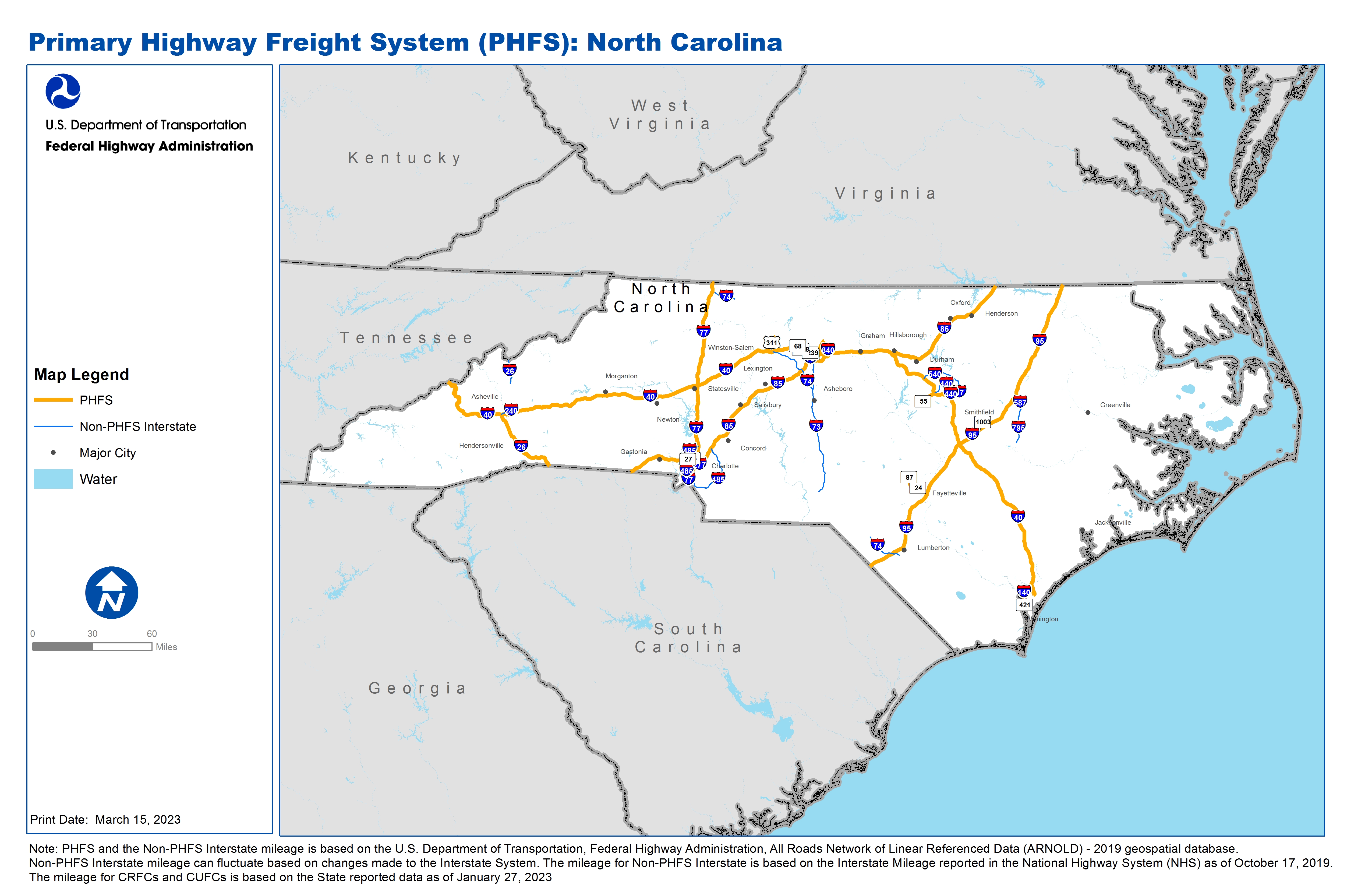
National Highway Freight Network Map and Tables for North Carolina, 2022
High-Resolution Images
- JPG 3.5MB
Table of National Highway Freight Network Routes, 2022
State |
Route No/ Facility Name |
Start Point |
End Point |
Route/Facility Description |
Length (Miles) |
|---|---|---|---|---|---|
NC |
I140 |
U421 |
I40 |
I140 from U421 to I40 |
6.79 |
NC |
I26 |
SC/NC Line |
I40 |
I26 from SC/NC Line to I40 |
39.87 |
NC |
I277 |
NC7R |
I77 |
I277 from NC7R to I77 |
1.37 |
NC |
I295 |
S24 |
NC10L |
I295 from S24 to NC10L |
1.50 |
NC |
I40 |
S132 |
NC/TN Line |
I40 from S132 to NC/TN Line |
419.16 |
NC |
I485 |
I77 |
I85 |
I485 from I77 to I85 |
9.86 |
NC |
U220 |
I85 |
I40 |
U220 from I85 to I40 |
2.31 |
NC |
I77 |
I485 |
NC/VA Line |
I77 from I485 to NC/VA Line |
103.76 |
NC |
I85 |
SC/NC Line |
I40 |
I85 from SC/NC Line to I40 |
132.30 |
NC |
I85 |
I40 |
NC/VA Line |
I85 from I40 to NC/VA Line |
71.03 |
NC |
I95 |
SC/NC Line |
NC/VA Line |
I95 from SC/NC Line to NC/VA Line |
181.36 |
NC |
S421 |
NC24P |
U17 |
S421 from NC24P to U17 |
0.98 |
NC |
S24 |
I295 |
I95 |
S24 from I295 to I95 |
11.15 |
NC |
S68 |
NC11A |
I40 |
S68 from NC11A to I40 |
2.08 |
NC |
S87 |
NC10L |
S24 |
S87 from NC10L to S24 |
2.93 |
NC |
U1 |
NC18L |
I40 |
U1 from NC18L to I40 |
6.93 |
NC |
U158 |
NC21R |
U52 |
U158 from NC21R to U52 |
0.26 |
NC |
U17 |
S1140 |
U421 |
U17 from S1140 to U421 |
0.82 |
NC |
U29 |
I40 |
7.24 Miles North of I40 |
U29 from I40 to 7.24 Miles North of I40 |
7.24 |
NC |
U421 |
U17 |
I140 |
U421 from U17 to I140 |
2.71 |
NC |
U52 |
I40 |
U158 |
U52 from I40 to U158 |
2.31 |
NC |
U70 |
NC25L |
I95 |
U70 from NC25L to I95 |
2.35 |
NC |
U74 |
U421 |
U17 |
U74 from U421 to U17 |
1.50 |
NC |
NC10L - Star Enterprise Pipeline Terminal |
I295 |
Star Enterprise Pipeline Terminal |
S210 from I295 to Murchison Blvd to Shaw Mill Rd |
0.87 |
NC |
NC11A - Piedmont Triad Int Airport - Greensboro |
S68 |
Piedmont Triad Int Airport - Greensboro |
SR 2085 between NC 68 and the Parking Lot Entrance |
0.97 |
NC |
NC12L - Petroleum Pipeline Terminal - Greensboro |
I40 |
Petroleum Pipeline Terminal - Greensboro |
SR 1554 (Chimney Rock Rd) and SR 1008 between I-40 and the Amoco Entrance on SR 1008 |
1.48 |
NC |
NC13R - Norfolk Southern Corp. - Greensboro |
I40 |
Norfolk Southern Corp. - Greensboro |
Terminal Entrance to Merritt Dr to NC 6 to Holden Rd to Meadowview Rd to SR 4121 (High Point Rd) to I-4 |
1.87 |
NC |
NC18L - Dixie Pipeline Co. - Apex |
U1 |
Dixie Pipeline Co. - Apex |
Terminal Entrance to NC 55 to US 1 |
2.77 |
NC |
NC1A - Asheville Regional Airport |
I26 |
Asheville Regional Airport |
NC 280 between I-26 and the Parking Lot Entrance |
0.24 |
NC |
NC21R – Norfolk Southern Corp. - Winston-Salem |
I40 |
Norfolk Southern Corp. - Winston-Salem |
I-40 Business to MLK Dr to US 311 to Williston Dr to Old Walkertown Rd to Terminal Entrance |
6.74 |
NC |
NC24P - NC State Ports - Wilmington |
U421 |
NC State Ports - Wilmington |
SR 1140 (Burnett St) from US 421 to Myers St |
0.35 |
NC |
NC25L - Petroleum Pipeline Terminal - Selma |
U70 |
Petroleum Pipeline Terminal - Selma |
SR 1003 between US 70 and SR 1928 |
1.27 |
NC |
NC2L - Petroleum Pipeline Terminal - Charlotte |
I85 |
Petroleum Pipeline Terminal - Charlotte |
NC 27 between I-85 and SR 1784(Mount Holly Rd) |
3.51 |
NC |
NC3R - CSX Freight Intermodal Facility - Charlotte |
I85 |
CSX Freight Intermodal Facility - Charlotte |
Hovis Rd and NC 16 between I-85 and the Terminal Entrance |
1.76 |
NC |
NC7R - Norfolk Southern Corp. - Charlotte |
I277 |
Norfolk Southern Corp. - Charlotte |
N. Brevard St and Caldwell St/Parkwood Ave between I-277 and the Terminal Entrance |
0.95 |
PHFS Total |
|
|
|
|
1033.35 |
State |
Route No/ Facility Name |
Start Point |
End Point |
Route/Facility Description |
Length (Miles) |
|---|---|---|---|---|---|
NC |
I240 |
I40 |
I40 |
I240 from I40 to I40 |
10.29 |
NC |
I26 |
0.87 Miles South of Old US 23 |
NC/TN Line |
I26 from 0.87 Miles South of Old US 23 to NC/TN Line |
12.59 |
NC |
I277 |
I77 |
N Brevard St |
I277 from I77 to N Brevard St |
3.10 |
NC |
I440 |
I40 (West) |
I40 (East) |
I440 from I40 (West) to I40 (East) |
16.78 |
NC |
I485 |
I85 (South) |
I77 (North) |
I485 from I85 (South) to I77 (North) |
11.97 |
NC |
I485 |
I77 (South) |
I85 (North) |
I485 from I77 (South) to I85 (North) |
37.07 |
NC |
I540 |
I40 |
U1 |
I540 from I40 to U1 |
16.34 |
NC |
I73 |
U220 |
I85 (North) |
I73 from U220 to I85 (North) |
53.75 |
NC |
I73 |
I85 (South) |
I40 |
I73 from I85 (South) to I40 |
6.95 |
NC |
I74 |
I77 |
U52 |
I74 from I77 to U52 |
12.54 |
NC |
I77 |
SC/NC Line |
I485 (South) |
I77 from SC/NC Line to I485 (South) |
1.72 |
NC |
I840 |
U70 |
I40 |
I840 from U70 to I40 |
2.21 |
NC |
I74 |
US74 |
S41 |
I74 from US74 to S41 |
19.22 |
NC |
I795 |
US70 |
I587 |
I795 from US70 to I587 |
21.12 |
NC |
I587 |
I95 |
I795 |
I587 from USI95 to I795 |
4.31 |
NC |
I73 |
US220 |
US220 Alt |
I73 from US220 to US220 Alt |
15.96 |
NC |
I540 |
I87 |
US1 |
I540 from I87 to US1 |
9.49 |
NC |
I87 |
I440 |
I540 |
I87 from I440 to I540 |
4.15 |
NC |
I74 |
I73 |
I40 |
I74 from I73 to I40 |
31.53 |
NC |
I73 |
I40 |
Joseph M Bryan Blvd |
I73 from I40 to Joseph M Bryan Blvd |
3.62 |
INTERSTATE NON-PHFS Total |
294.71 |
Note: PHFS and the Non-PHFS Interstate mileage is based on the U.S. Department of Transportation, Federal Highway Administration, All Roads Network of Linear Referenced Data (ARNOLD) - 2019 geospatial database. Non-PHFS Interstate mileage can fluctuate based on changes made to the Interstate System. The mileage for Non-PHFS Interstate is based on the Interstate Mileage reported in the National Highway System (NHS) as of October 17, 2019. The mileage for CRFCs and CUFCs is based on the State reported data as of January 27, 2023