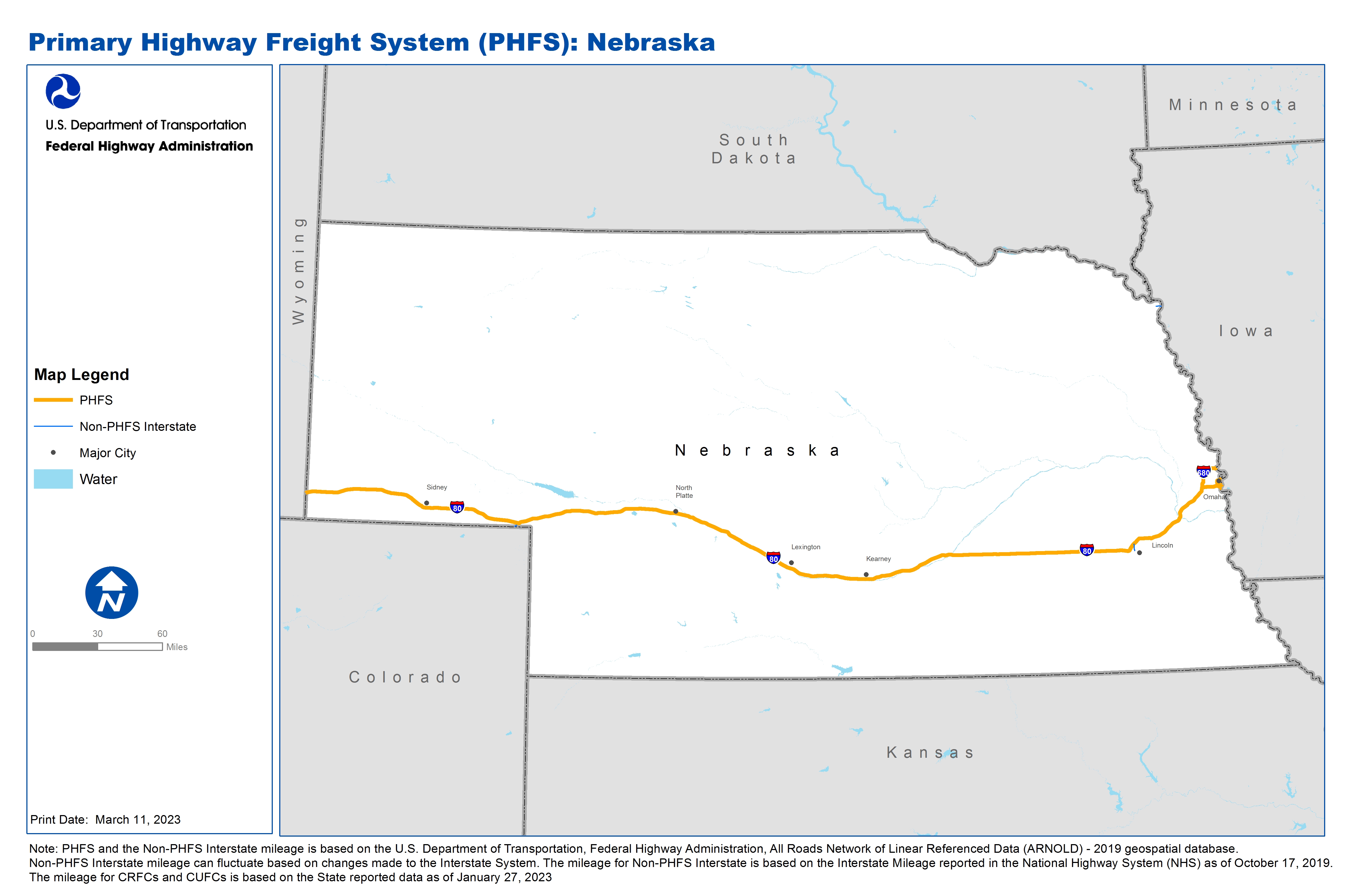
National Highway Freight Network Map and Tables for Nebraska, 2022

High-Resolution Images
- JPG 2.0MB
Table of National Highway Freight Network Map Routes, 2022
State |
Route No/ Facility Name |
Start Point |
End Point |
Route/Facility Description |
Length (Miles) |
|---|---|---|---|---|---|
NE |
I480 |
I80 |
NE2L/NE3R |
I480 from I80 to NE2L/NE3R |
3.51 |
NE |
I80 |
WY/NE Line |
NE/IA Line |
I80 from WY/NE Line to NE/IA Line |
455.17 |
NE |
I680 |
I80 |
NE/IA Line |
I680 from I80 to NE/IA Line |
13.33 |
NE |
NE2L - WILLIAMS PIPELINE |
I480 |
WILLIAMS PIPELINE |
11TH (Terminal to Izard), Izard (11th to 14th), 14th St (Izard to I-480) |
0.96 |
NE |
NE3R - UNION PACIFIC RAILROAD |
I480 |
UNION PACIFIC RAILROAD |
Leavenworth (Terminal to 14), 14th (Leavenworth to I-480), 13th (Leavenworth toI-480) |
1.60 |
NE |
NE4R - BURLINGTON NORTHERN RAILROAD |
I80 |
BURLINGTON NORTHERN RAILROAD |
SOUTH AND NORTH ON GIBSON ROAD TO 13TH STREET, THEN NORTH TO I-80 |
1.65 |
PHFS Total |
|
|
|
|
476.22 |
State |
Route No/ Facility Name |
Start Point |
End Point |
Route/Facility Description |
Length (Miles) |
|---|---|---|---|---|---|
NE |
I129 |
U77 |
NE/IA Line |
I129 from U77 to NE/IA Line |
2.85 |
NE |
I180 |
I80 |
S34 |
I180 from I80 to S34 |
3.41 |
NE |
I480 |
14th St |
NE/IA Line |
I480 from 14th St to NE/IA Line |
0.68 |
NE |
I76 |
CO/NE Line |
I80 |
I76 from CO/NE Line to I80 |
2.47 |
INTERSTATE NON-PHFS Total |
|
|
|
|
9.41 |
Note: PHFS and the Non-PHFS Interstate mileage is based on the U.S. Department of Transportation, Federal Highway Administration, All Roads Network of Linear Referenced Data (ARNOLD) - 2019 geospatial database. Non-PHFS Interstate mileage can fluctuate based on changes made to the Interstate System. The mileage for Non-PHFS Interstate is based on the Interstate Mileage reported in the National Highway System (NHS) as of October 17, 2019. The mileage for CRFCs and CUFCs is based on the State reported data as of January 27, 2023
Sources
U.S. Department of Transportation, Federal Highway Administration, Freight Analysis Framework,
Version 4, 2015, Highway Performance Monitoring System 2012.