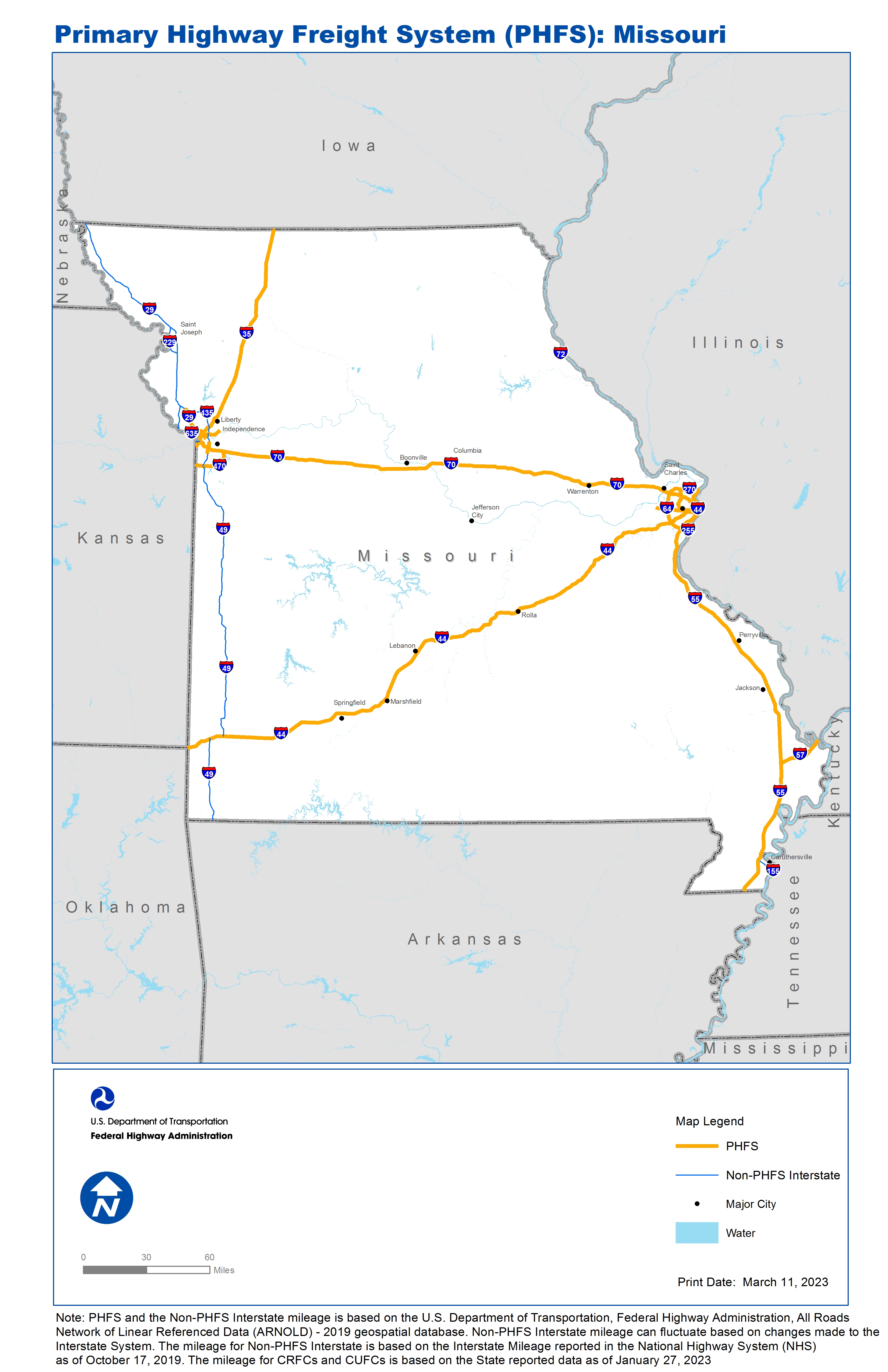
National Highway Freight Network Map and Tables for Missouri, 2022

High-Resolution Images
- JPG 2.7MB
Table of National Highway Freight Network Routes, 2022
State |
Route No/ Facility Name |
Start Point |
End Point |
Route/Facility Description |
Length (Miles) |
|---|---|---|---|---|---|
MO |
I170 |
I64 |
I270 |
I170 from I64 to I270 |
11.09 |
MO |
I255 |
I55 |
MO/IL Line |
I255 from I55 to MO/IL Line |
3.98 |
MO |
I270 |
I55 |
MO/IL Line |
I270 from I55 to MO/IL Line |
35.74 |
MO |
I29 |
I70 |
MO2A |
I29 from I70 to MO2A |
19.66 |
MO |
I35 |
KS/MO Line |
I670 |
I35 from KS/MO Line to I670 |
2.02 |
MO |
I35 |
I29 |
MO/IA Line |
I35 from I29 to MO/IA Line |
106.01 |
MO |
I435 |
KS/MO Line |
I470 |
I435 from KS/MO Line to I470 |
3.56 |
MO |
I435 |
S350 |
U24 |
I435 from S350 to U24 |
6.15 |
MO |
I44 |
OK/MO Line |
I55 |
I44 from OK/MO Line to I55 |
291.64 |
MO |
I470 |
I435 |
I70 |
I470 from I435 to I70 |
16.80 |
MO |
I55 |
AR/MO Line |
MO/IL Line |
I55 from AR/MO Line to MO/IL Line |
209.26 |
MO |
I57 |
I55 |
MO/IL Line |
I57 from I55 to MO/IL Line |
22.05 |
MO |
I64 |
S340 |
MO/IL Line |
I64 from S340 to MO/IL Line |
20.97 |
MO |
I670 |
KS/MO Line |
I70 |
I670 from KS/MO Line to I70 |
2.32 |
MO |
I70 |
I29 |
I55 |
I70 from I29 to I55 |
247.49 |
MO |
MO10R - Norfolk Southern/Triple Crown, St. Louis |
I70 |
Norfolk Southern/Triple Crown, St. Louis |
From I-70 (exit 247): NE 0.3 mi on Grand, NW 1.5 mi on Hall to intermodal facility. From I-270 (exit 34): SW 5.7 mi on Riverdale Dr and continuing o Hall Street to terminal. . |
7.52 |
MO |
MO17P - Port of St. Louis #2 |
I55 |
Port of St. Louis #2 |
7th St. (I-55/44 to I-55) |
1.98 |
MO |
MO2A - Kansas City International Airport |
I29 |
Kansas City International Airport |
From I-29/435 (ex 15): S 1.5 mi on Mexico City Ave to Air Cargo Facility on Paris Street |
3.66 |
MO |
MO7R - Union Pacific, Kansas City |
S210 |
Union Pacific, Kansas City |
From Route 210 intermodal connector: S 2.0 mi on Chouteau Trafficway to facility entrance on Gardner Ave |
1.86 |
MO |
MO8R - Norfolk Southern/Triple Crown, KC |
I29 |
Norfolk Southern/Triple Crown, KC |
From I-29/35 (ex 6B): E 5.5 mi on Route 210 to Facility Entrance. From State Route 291: SW 4.5 mi on Route 210 to facility entrance |
9.99 |
PHFS Total |
|
|
|
|
1,023.75 |
State |
Route No/ Facility Name |
Start Point |
End Point |
Route/Facility Description |
Length (Miles) |
|---|---|---|---|---|---|
MO |
I155 |
TN/MO Line |
I55 |
I155 from TN/MO Line to I55 |
10.57 |
MO |
I229 |
I29 (South) |
I229 (North) |
I229 from I29 (South) to I229 (North) |
14.94 |
MO |
I29 |
Mexico City Ave |
KS/IA Line |
I29 from Mexico City Ave to KS/IA Line |
109.12 |
MO |
I35 |
I670 |
I29 |
I35 from I670 to I29 |
1.97 |
MO |
I435 |
KS/MO Line |
I29 |
I435 from KS/MO Line to I29 |
11.40 |
MO |
I435 |
I470 |
S350 |
I435 from I470 to S350 |
6.53 |
MO |
I435 |
U24 |
I29 (North) |
I435 from U24 to I29 (North) |
24.46 |
MO |
I635 |
KS/MO Line |
I29 |
I635 from KS/MO Line to I29 |
3.70 |
MO |
I70 |
KS/MO Line |
I35 (West) |
I70 from KS/MO Line to I35 (West) |
0.89 |
MO |
I72 |
U61 |
MO/IL Line |
I72 from U61 to MO/IL Line |
1.87 |
MO |
I49 |
AR/MO Line |
I44 |
I49 from AR/MO Line to I44 |
40.70 |
MO |
I49 |
0.05 Miles South of I44 |
I470 |
I49 from 0.05 Miles South of I44 to I470 |
136.74 |
INTERSTATE NON-PHFS Total |
362.89 |
Note: PHFS and the Non-PHFS Interstate mileage is based on the U.S. Department of Transportation, Federal Highway Administration, All Roads Network of Linear Referenced Data (ARNOLD) - 2019 geospatial database. Non-PHFS Interstate mileage can fluctuate based on changes made to the Interstate System. The mileage for Non-PHFS Interstate is based on the Interstate Mileage reported in the National Highway System (NHS) as of October 17, 2019. The mileage for CRFCs and CUFCs is based on the State reported data as of January 27, 2023
Sources
U.S. Department of Transportation, Federal Highway Administration, Freight Analysis Framework,
Version 4, 2015, Highway Performance Monitoring System 2012.