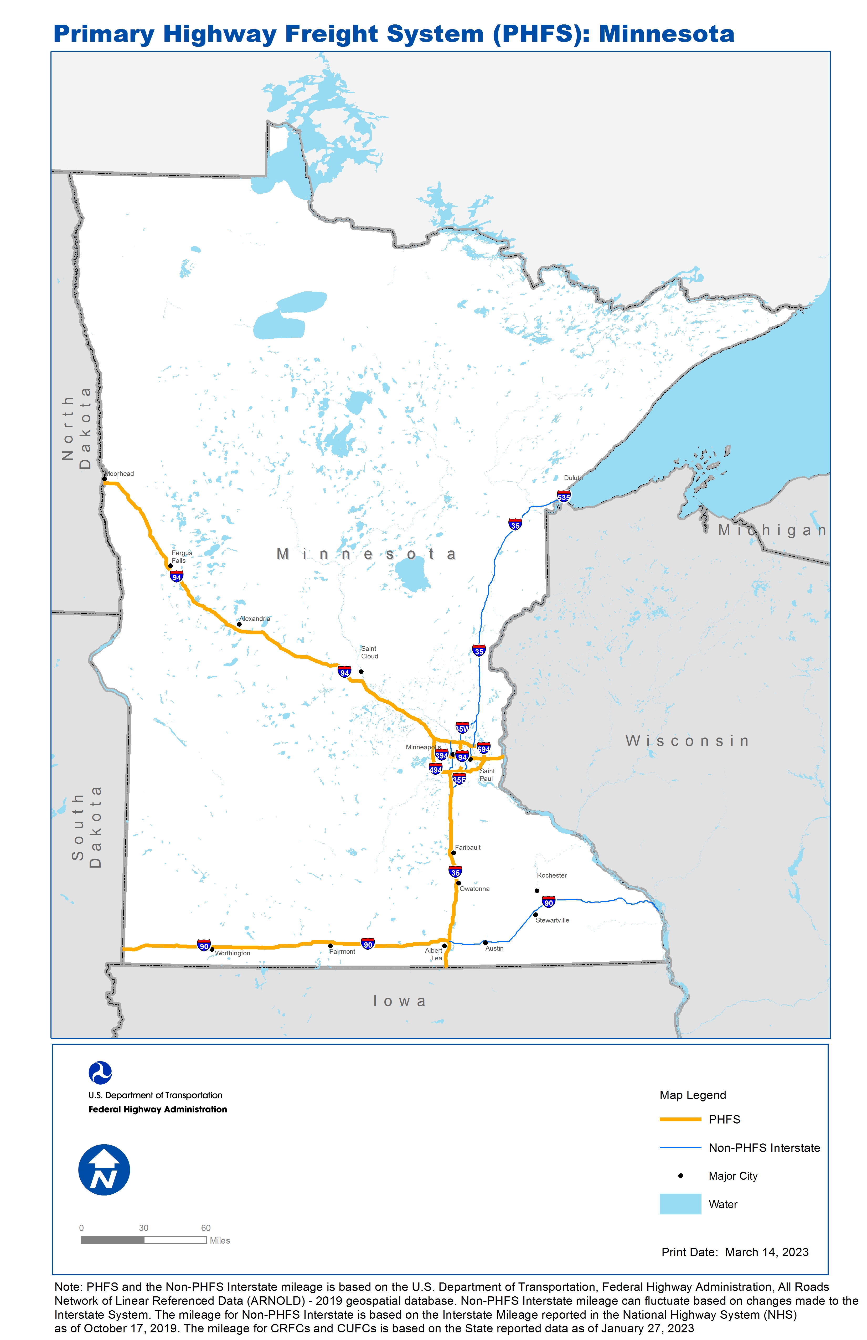
National Highway Freight Network Map and Tables for Minnesota, 2022
High-Resolution Images
- JPG 3.2MB
Table of National Highway Freight Network Routes, 2022
State |
Route No/ Facility Name |
Start Point |
End Point |
Route/Facility Description |
Length (Miles) |
|---|---|---|---|---|---|
MN |
I35 |
IA/MN Line |
I35W |
I35 from IA/MN Line to I35W |
88.25 |
MN |
I35W |
I35 |
I494 |
I35W from I35 to I494 |
8.76 |
MN |
I35W |
I694 |
3.67 Miles South of I694 |
I35W from I694 to 3.67 Miles South of I694 |
3.64 |
MN |
I394 |
I494 |
I94 |
I394 from I494 to I94 |
8.66 |
MN |
I494 |
I94 |
I94 |
I494 from I94 to I94 |
42.84 |
MN |
I694 |
I94 |
I94 |
I694 from I94 to I94 |
23.80 |
MN |
I90 |
SD/MN Line |
I35 |
I90 from SD/MN Line to I35 |
159.75 |
MN |
I94 |
ND/MN Line |
I694 (West) |
I94 from ND/MN Line to I694 (West) |
223.98 |
MN |
I94 |
I394 |
MN/WI Line |
I94 from I394 to MN/WI Line |
27.50 |
MN |
S5 |
I494 |
MN1A |
S5 from I494 to MN1A |
0.76 |
MN |
MN1A - Minneapolis/St. Paul Airport |
S5 |
Minneapolis/St. Paul Airport |
S-5 (S-55 to Post Rd) |
1.60 |
PHFS Total |
|
|
|
|
589.54 |
State |
Route No/ Facility Name |
Start Point |
End Point |
Route/Facility Description |
Length (Miles) |
|---|---|---|---|---|---|
MN |
I35 |
I35E (North) |
S61 |
I35 from I35E (North) to S61 |
132.05 |
MN |
I35E |
I35 (South) |
I694 (West) |
I35E from I35 (South) to I694 (West) |
25.19 |
MN |
I35E |
I694 (East) |
I35 (North) |
I35E from I694 (East) to I35 (North) |
13.30 |
MN |
I35W |
I494 |
S36 |
I35W from I494 to S36 |
14.35 |
MN |
I35W |
I694 |
I35 (North) |
I35W from I694 to I35 (North) |
15.06 |
MN |
I394 |
I94 |
1.08 Miles East of I94 |
I394 from I94 to 1.08 Miles East of I94 |
1.09 |
MN |
I535 |
WI/MN Line |
I35 |
I535 from WI/MN Line to I35 |
1.57 |
MN |
I90 |
I35 |
MN/WI Line |
I90 from I35 to MN/WI Line |
115.77 |
MN |
I94 |
I694 |
I394 |
I94 from I694 to I394 |
6.78 |
INTERSTATE NON-PHFS Total |
|
|
|
|
325.16 |
Note: PHFS and the Non-PHFS Interstate mileage is based on the U.S. Department of Transportation, Federal Highway Administration, All Roads Network of Linear Referenced Data (ARNOLD) - 2019 geospatial database. Non-PHFS Interstate mileage can fluctuate based on changes made to the Interstate System. The mileage for Non-PHFS Interstate is based on the Interstate Mileage reported in the National Highway System (NHS) as of October 17, 2019. The mileage for CRFCs and CUFCs is based on the State reported data as of January 27, 2023
Sources
U.S. Department of Transportation, Federal Highway Administration, All Roads Network of Linear Referenced Data (ARNOLD) 2019.