National Highway Freight Network Map and Tables for Maine, 2022
High-Resolution Images
- JPG 2.9MB
Table of National Highway Freight Network Routes, 2022
State |
Route No/ Facility Name |
Start Point |
End Point |
Route/Facility Description |
Length (Miles) |
|---|---|---|---|---|---|
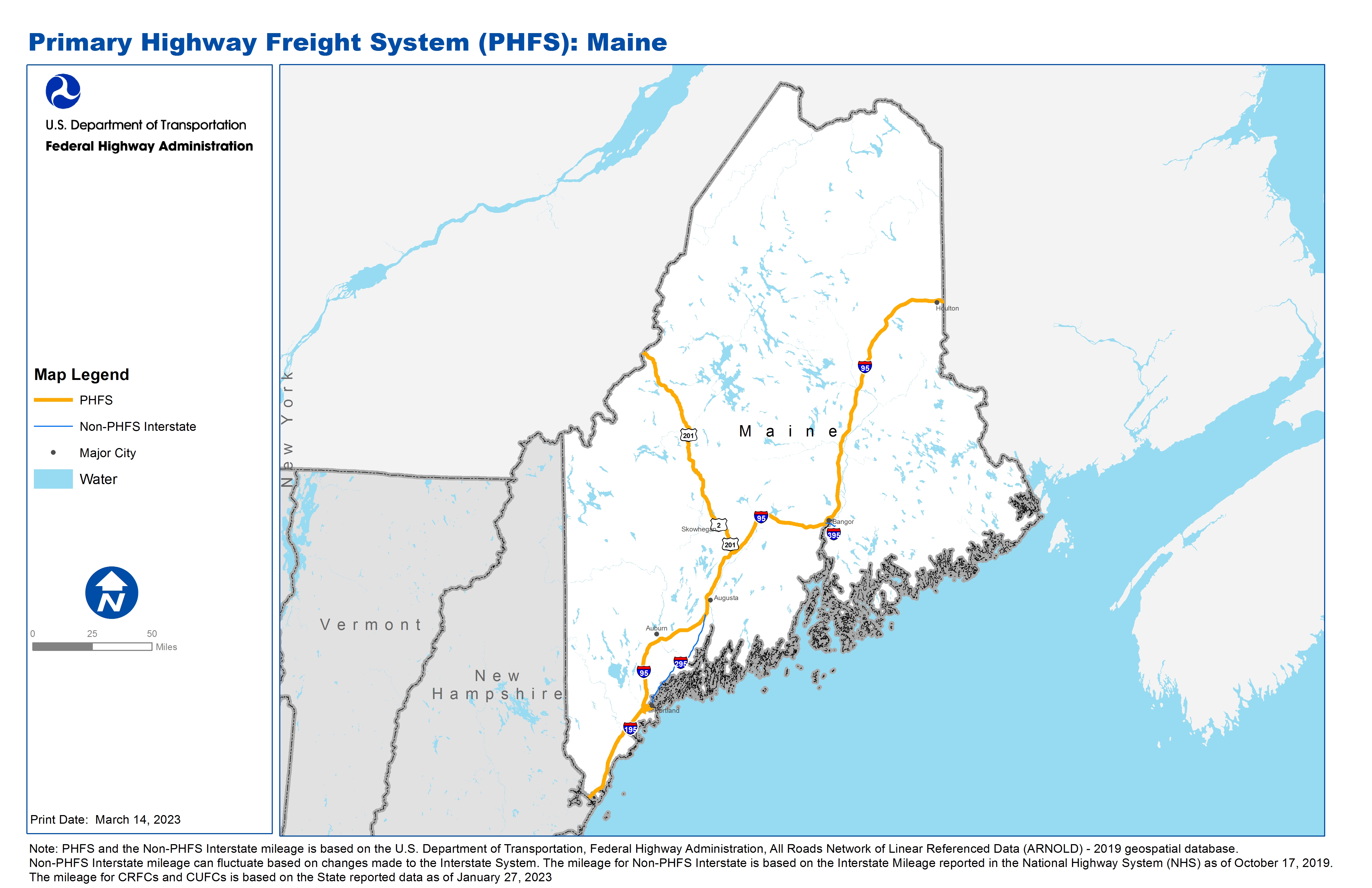
ME |
I95 |
NH/ME Line |
ME/NB Line |
I95 from NH/ME Line to ME/NB Line |
303.01 |
ME |
U2 |
U201 |
U201 |
U2 from U201 to U201 |
1.19 |
ME |
U201 |
I95 |
U2 |
U201 from I95 to U2 |
14.29 |
ME |
U201 |
U2 |
ME/QC Line |
U201 from U2 to ME/QC Line |
87.96 |
ME |
ME12P - International Marine Terminal |
Veterans Memorial Bridge |
International Marine Terminal |
Fore River Pkwy and Commercial St/ U1A (Veterans Memorial Bridge to S77) |
1.18 |
ME |
ME1R - Portland Freight Terminal District |
I95 |
Portland Freight Terminal District |
From I-95 (exit 7): south 2.1 mi on ME Turnpike Approach Road to U.S. 1 |
2.09 |
ME |
ME2A - Portland Jetport |
I95 |
Portland Jetport |
From I-95 (exit 7): northeast 1.3 mi on Maine Mall Road to SR 9 in South Portland. From I-295 (exit 5): SW 2.4 mi on SR9/SR 22 to Jetport Access Road. From I-295 (exit 3): NW 1.7 mi on SR 9 to Jetport Access Road in South Portland |
5.21 |
ME |
ME4P - Merrill Marine Terminal (Port) |
I295 |
Merrill Marine Terminal (Port) |
From I-295 (exit 5): 0.8 mi E on SR 22/Congress St, 0.8 mi S on U.S. 1, 0.2 mi E on U.S. 1A. From I-295 (exit 4): 1.0 E on U.S. 1A to intersection with U.S.1 (and join connector #1) |
2.25 |
PHFS Total |
|
|
|
|
417.18 |
State |
Route No/ Facility Name |
Start Point |
End Point |
Route/Facility Description |
Length (Miles) |
|---|---|---|---|---|---|
ME |
I195 |
I95 |
S5 |
I195 from I95 to S5 |
2.49 |
ME |
I295 |
I95 |
I95 |
I295 from I95 to I95 |
52.55 |
ME |
I395 |
I95 |
US1A |
I395 from I95 to US1A |
4.73 |
INTERSTATE NON-PHFS Total |
|
|
|
|
59.77 |
Note: PHFS and the Non-PHFS Interstate mileage is based on the U.S. Department of Transportation, Federal Highway Administration, All Roads Network of Linear Referenced Data (ARNOLD) - 2019 geospatial database. Non-PHFS Interstate mileage can fluctuate based on changes made to the Interstate System. The mileage for Non-PHFS Interstate is based on the Interstate Mileage reported in the National Highway System (NHS) as of October 17, 2019. The mileage for CRFCs and CUFCs is based on the State reported data as of January 27, 2023
Sources
U.S. Department of Transportation, Federal Highway Administration, All Roads Network of Linear Referenced Data (ARNOLD) 2019.