National Highway Freight Network Map and Tables for Kansas, 2022
High-Resolution Images
- JPG 2.2MB
Table of Final Primary Freight Network Routes, 2022
|
State |
Route No/ Facility Name |
Start Point |
End Point |
Route/Facility Description |
Length (Miles) |
|---|---|---|---|---|---|
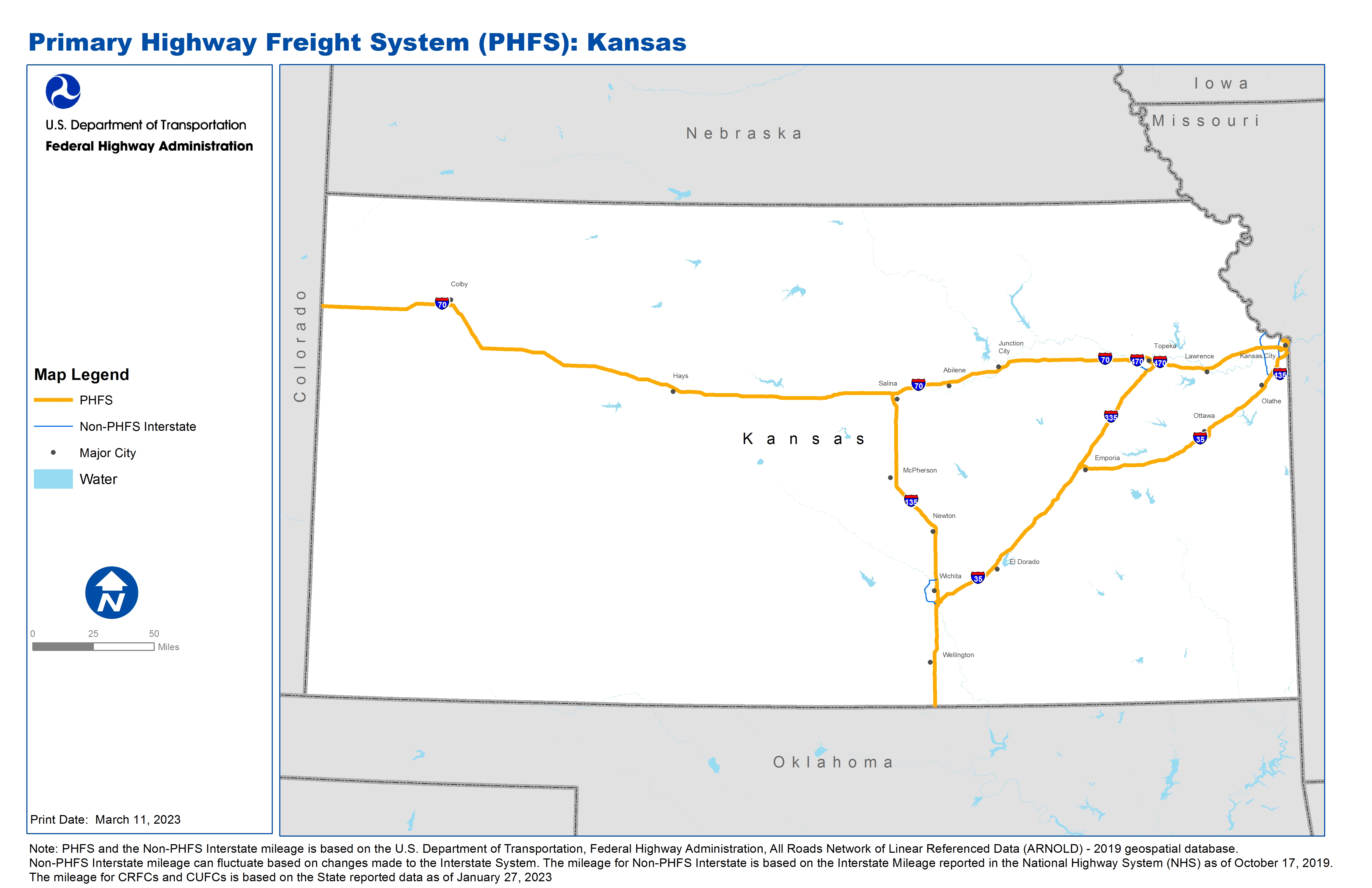
KS |
I135 |
I35 |
I70 |
I135 from I35 to I70 |
95.95 |
KS |
I335 |
I35 |
I470 |
I335 from I35 to I470 |
50.30 |
KS |
I35 |
KS/MO Line |
KS/MO Line |
I35 from KS/MO Line to KS/MO Line |
235.47 |
KS |
I470 |
I335 |
I70 |
I470 from I335 to I70 |
6.87 |
KS |
I635 |
KS2R |
I70 |
I635 from KS2R to I70 |
1.02 |
KS |
I670 |
I70 |
KS/MO Line |
I670 from I70 to KS/MO Line |
1.81 |
KS |
I70 |
KS4L |
CO/KS Line |
I70 from KS4L to CO/KS Line |
423.10 |
KS |
KS2R - Santa Fe Terminal, Kansas City |
I635 |
Santa Fe Terminal, Kansas City |
From I-635 E on K-32 for 0.462 mi, S 0.1 mi on 39th, E 0.1 mi on Fairbanks, S 0.1 mi on 38th. From U.S. 69 W on K32 for 1.248 mi, S 0.1 mi on 39th, E 0.1 mi on Fairbanks, S 0.1 mi on 38th |
1.99 |
KS |
KS3R - Southern Pacific's KS City I'mdl Fac. |
I635 |
Southern Pacific's KS City I'mdl Fac. |
From I-635 E on K-32 for 1.710 mi, N 0.2 mi under 18th, 0.3 mi W on Baynard. From U.S. 69 under 18th St heading N, W on Baynard (no additional miles) |
0.66 |
KS |
KS4L - Williams Pipeline Terminal |
I635 |
Williams Pipeline Terminal |
From I-635 E on K5 for ~2.242 mi, E 1.150 mi on Sunshine Rd, S 1.0 mi on Fairfax, EN 0.490 mi on Donovan. From I-70 on Fairfax for 1.510 mi, EN 0.49 on Donovan |
5.45 |
PHFS Total |
|
|
|
|
822.63 |
State |
Route No/ Facility Name |
Start Point |
End Point |
Route/Facility Description |
Length (Miles) |
|---|---|---|---|---|---|
KS |
I235 |
I135 (South) |
I135 (North) |
I235 from I135 (South) to I135 (North) |
16.68 |
KS |
I435 |
MO/KS Line (South) |
MO/KS Line (North) |
I435 from MO/KS Line (South) to MO/KS Line (North) |
27.99 |
KS |
I470 |
I70 |
I335 |
I470 from I70 to I335 |
6.88 |
KS |
I635 |
I35 |
S32 |
I635 from I35 to S32 |
3.55 |
KS |
I635 |
I70 |
KS/MO Line |
I635 from I70 to KS/MO Line |
4.37 |
KS |
I70 |
U24 |
KS/MO Line |
I70 from U24 to KS/MO Line |
0.62 |
INTERSTATE NON-PHFS Total |
|
|
|
|
60.09 |
Note: PHFS and the Non-PHFS Interstate mileage is based on the U.S. Department of Transportation, Federal Highway Administration, All Roads Network of Linear Referenced Data (ARNOLD) - 2019 geospatial database. Non-PHFS Interstate mileage can fluctuate based on changes made to the Interstate System. The mileage for Non-PHFS Interstate is based on the Interstate Mileage reported in the National Highway System (NHS) as of October 17, 2019. The mileage for CRFCs and CUFCs is based on the State reported data as of January 27, 2023
Sources
U.S. Department of Transportation, Federal Highway Administration, All Roads Network of Linear Referenced Data (ARNOLD) 2019.