National Highway Freight Network Map and Tables for Illinois, 2022
High-Resolution Images
- JPG 2.8MB
Table of National Highway Freight Network Routes, 2022
|
State |
Route No/ Facility Name |
Start Point |
End Point |
Route/Facility Description |
Length (Miles) |
|---|---|---|---|---|---|
IL |
I24 |
I57 |
IL/KY Line |
I24 from I57 to IL/KY Line |
37.81 |
IL |
I255 |
IL36R |
IL/MO Line |
I255 from IL36R to IL/MO Line |
5.41 |
IL |
I270 |
MO/IL Line |
I55 |
I270 from MO/IL Line to I55 |
15.20 |
IL |
I290 |
I90 |
I90 |
I290 from I90 to I90 |
29.84 |
IL |
I294 |
I94 |
I80 |
I294 from I94 to I80 |
49.41 |
IL |
I355 |
I55 |
I88 |
I355 from I55 to I88 |
7.72 |
IL |
I39 |
I55 |
I90 |
I39 from I55 to I90 |
124.54 |
IL |
I55 |
MO/IL Line |
U41 |
I55 from MO/IL Line to U41 |
293.89 |
IL |
I57 |
MO/IL Line |
I80 |
I57 from MO/IL Line to I80 |
344.70 |
IL |
I57 |
IL21R |
I94 |
I57 from IL21R to I94 |
4.11 |
IL |
I64 |
I55 |
I57 |
I64 from I55 to I57 |
71.30 |
IL |
I64 |
I57 |
IL/KY Line |
I64 from I57 to IL/KY Line |
52.48 |
IL |
I70 |
I55 |
I57 |
I70 from I55 to I57 |
77.37 |
IL |
I70 |
I57 |
IL/IN Line |
I70 from I57 to IL/IN Line |
57.74 |
IL |
I74 |
U150 |
I55 |
I74 from U150 to I55 |
32.35 |
IL |
I74 |
I55 |
I57 |
I74 from I55 to I57 |
45.76 |
IL |
I80 |
IA/IL Line |
IL/IN Line |
I80 from IA/IL Line to IL/IN Line |
163.42 |
IL |
I88 |
I290 |
0.16 Miles West of Farnsworth Ave |
I88 from I290 to 0.16 Miles West of Farnsworth Ave |
21.77 |
IL |
I90 |
WI/IL Line |
I94 |
I90 from WI/IL Line to I94 |
85.00 |
IL |
I94 |
WI/IL Line |
I80 |
I94 from WI/IL Line to I80 |
74.58 |
IL |
U12 |
IL4R |
IL3R |
U12 from IL4R to IL3R |
2.71 |
IL |
S8 |
U24 |
S116 |
S8 from U24 to S116 |
1.29 |
IL |
S116 |
S8 |
Washington St |
S116 from S8 to Washington St |
0.30 |
IL |
S3 |
IL33R |
I270 |
S3 from IL33R to I270 |
7.77 |
IL |
S43 |
IL19R |
I55 |
S43 from IL19R to I55 |
2.64 |
IL |
S50 |
I290 |
U12 |
S50 from I290 to U12 |
10.48 |
IL |
S59 |
IL27R |
I88 |
S59 from IL27R to I88 |
2.31 |
IL |
Torrence Ave |
IL29P |
IL31P |
Torrence Ave from IL29P to IL31P |
0.74 |
IL |
U24 |
S29 |
I74 |
U24 from S29 to I74 |
0.69 |
IL |
Washington St |
Adams St |
S116 |
Washington St from Adams St to S116 |
1.55 |
IL |
IL121R - CSXI 59TH Street |
I94 |
CSXI 59TH Street |
59th St (Entrance to Western and Wentworth@I- 90/94) |
3.01 |
IL |
IL123R - BNSF Logistics Park Chicago |
I55 |
BNSF Logistics Park Chicago |
Arsenal Rd (Relocated I-55 Interchange to Baseline Road), Baseline Rd (Arsenal Rd to terminal exit gate) |
5.39 |
IL |
IL14R - Corwith (BN/SF) |
I55 |
Corwith (BN/SF) |
Kedzie Ave (Entrance @ 41st St to I-55). Kedzie Ave (41st to 47th), 47th St (Kedzie to Western). 47th ST (Kedzie to Pulaski), Pulaski (47th to I-55), 41st St (Entrance at Hamlin to Pulaski) |
4.76 |
IL |
IL15R - 47th Yard (Norfolk Southern) |
I94 |
47th Yard (Norfolk Southern) |
51st St. (Exit to Wentworth at I-90/94). 47th St. (Normal to I-90/94), Wentworth (47th to I-90/94 ramps) |
0.31 |
IL |
IL16R - 63rd Yard - Conrail |
I94 |
63rd Yard - Conrail |
63rd St (Entrance@Indiana to I-90/94@Well). 61st St (Entrance to State); along Wells, 59th |
2.09 |
IL |
IL17R - Forest Hill - CSX Intermodal |
Western Ave |
Forest Hill - CSX Intermodal |
79th St. (Entrance to Western Ave.) |
0.19 |
IL |
IL18R - Landers - Norfolk Southern |
Western Ave |
Landers - Norfolk Southern |
79th St. (Cicero to Western) |
3.02 |
IL |
IL19R - Bedford Park - CSX Intermodal |
S43 |
Bedford Park - CSX Intermodal |
71st St. (Entrance to IL 43). Frontage Rd. (Entrance to IL 43). Sayer (71st to 73rd), 73rd (Sayer to Cicero). Narragansett (Entrance to 73rd) |
3.28 |
IL |
IL1R - Schiller Park East |
U45 |
Schiller Park East |
Lawrence Ave. (Entrance to US 45) |
0.42 |
IL |
IL20R - Willow Springs/Hodgkins (BN/S) |
I294 |
Willow Springs/Hodgkins (BN/S) |
75th St. (Entrance to I-294). Santa Fe Dr (Entrance to 67th), 67th St (Santa Fe to US 45) |
2.32 |
IL |
IL21R - Iowa Interstate |
I57 |
Iowa Interstate |
119th St. (Wolcott to I-57) |
0.98 |
IL |
IL22R - Yard Center (Union Pacific) |
I94 |
Yard Center (Union Pacific) |
Sibley Rd (IL 83): from Indiana to I-94; Indiana: from Entrance to Sibley |
1.97 |
IL |
IL23R - Moyers International (IC/UP/WC) |
I80 |
Moyers International (IC/UP/WC) |
Center St (Entrance to 167th), 167th St (Center to Halsted), Halsted (167th to I-80). Center St. (167th to 159th). Center (Entrance to 171st), 171st St (Center to Halstead) |
3.22 |
IL |
IL25R - IMX (Union Pacific) |
I55 |
IMX (Union Pacific) |
Damen St. (30th Ave to I-55) |
0.18 |
IL |
IL26R - Triple Crown - Norfolk Southern |
I94 |
Triple Crown - Norfolk Southern |
103rd St. (Stoney Island Rd to I-94) |
1.70 |
IL |
IL29P - Water Terminal 1 - Calumet River |
I94 |
Water Terminal 1 - Calumet River |
103rd St. (Torrence to Stoney Island then to I- 94). 106th ST (Indianapolis Blvd to Torrence) |
1.82 |
IL |
IL30P - Water Terminal 2 - Lake Calumet |
I94 |
Water Terminal 2 - Lake Calumet |
Stoney Island (130th St to 103rd St/I-94 Ramps). 122nd St (Stoney Island to Torrence). Stoney Island (Entrance to 130th). |
4.09 |
IL |
IL31P - Water Terminal 3 - KCBX Cluster |
Torrence |
Water Terminal 3 - KCBX Cluster |
100th St. (Entrance to Indianapolis), Indianapolis (100th to US 12/20). 100th St (Entrance to Torrence) |
1.30 |
IL |
IL32R - Peoria & Pekin Union Intermodal |
S116 |
Peoria & Pekin Union Intermodal |
Oxford (Entrance to Wesley), Wesley (Oxford to Main), Main (Wesley to IL 8/116) |
1.16 |
IL |
IL33R - Gateway Western Intermodal Yard |
S3 |
Gateway Western Intermodal Yard |
Main St (Entrance to IL 3) |
0.37 |
IL |
IL34R - Rose Lake Intermodal Yard |
I55 |
Rose Lake Intermodal Yard |
Collinsville Rd (Entrance to IL 203), IL 203 (Collinsville to I-55) |
1.09 |
IL |
IL36R - Union Pacific Motor Freight Intermodal Yard |
S3 |
Union Pacific Motor Freight Intermodal Yard |
E. Carondelet (Entrance to Main), Main St. (Carondelet to IL 3) |
2.80 |
IL |
IL37P - Peoria Barge Terminal |
Washington St |
Peoria Barge Terminal |
Sanger St (Entrance to Washington St) |
0.31 |
IL |
IL3R - Bensenville (Canadian Pacific) |
U45 |
Bensenville (Canadian Pacific) |
Entrance on Franklin Ave. to Williams Dr. to Belmont Ave. to US 45 |
1.36 |
IL |
IL4R - Global Two |
S64 |
Global Two |
US 20 (Entrance to IL-64/Railroad Ave/US45). Railroad Ave. (US 20 to Il 64) |
1.97 |
IL |
IL5R - Cicero 26th St (BN/SF) |
S50 |
Cicero 26th St (BN/SF) |
26th St. (Entrance to IL 50) |
1.03 |
IL |
IL8R - Global One |
I55 |
Global One |
15th St. (Entrance to Ashland Ave), Ashland Ave. (15th to Frontage), Frontage Rd (Ashland to I- 290). Ashland Ave. (15th to I-55) |
2.83 |
IL |
IL9R - Western Ave (Burlington Northern) |
I55 |
Western Ave (Burlington Northern) |
Blue Island (Western to Ashland), Damen (Blue Island to 30th), Blue Island. 31st (Western to California), California (31st to I-55) - proposed |
2.64 |
PHFS Total |
|
|
|
|
1,680.51 |
|
State |
Route No/ Facility Name |
Start Point |
End Point |
Route/Facility Description |
Length (Miles) |
|---|---|---|---|---|---|
IL |
I155 |
I55 |
I74 |
I155 from I55 to I74 |
32.24 |
IL |
I172 |
I72 (East) |
U24 |
I172 from I72 (East) to U24 |
19.89 |
IL |
I180 |
I80 |
S26 |
I180 from I80 to S26 |
13.26 |
IL |
I190 |
I90 |
O'Hare Terminal |
I190 from I90 to O'Hare Terminal |
3.14 |
IL |
I255 |
S Main St, Dupo IL |
I270 |
I255 from S Main St, Dupo IL to I270 |
21.75 |
IL |
I280 |
IA/IL Line |
I74 |
I280 from IA/IL Line to I74 |
8.23 |
IL |
I355 |
I80 |
I55 (West) |
I355 from I80 to I55 (West) |
12.53 |
IL |
I355 |
I88 |
I290 |
I355 from I88 to I290 |
11.88 |
IL |
I474 |
I74 (West) |
I74 (East) |
I474 from I74 (West) to I74 (East) |
14.68 |
IL |
I57 |
I80 |
119th St, Chicago IL |
I57 from I80 to 119th St, Chicago IL |
9.44 |
IL |
I72 |
MO/IL Line |
I55 |
I72 from MO/IL Line to I55 |
97.81 |
IL |
I72 |
I55 |
I57 |
I72 from I55 to I57 |
78.63 |
IL |
I74 |
IA/IL Line |
U150/U24 |
I74 from IA/IL Line to U150/U24 |
95.12 |
IL |
I74 |
I57 |
IL/IN Line |
I74 from I57 to IL/IN Line |
41.10 |
IL |
I88 |
I80 |
2.00 Miles East of S31 |
I88 from I80 to 2.00 Miles East of S31 |
118.97 |
IL |
I90 |
I94 |
IL/IN Line |
I90 from I94 to IL/IN Line |
7.57 |
INTERSTATE NON-PHFS Total |
|
|
|
|
586.23 |
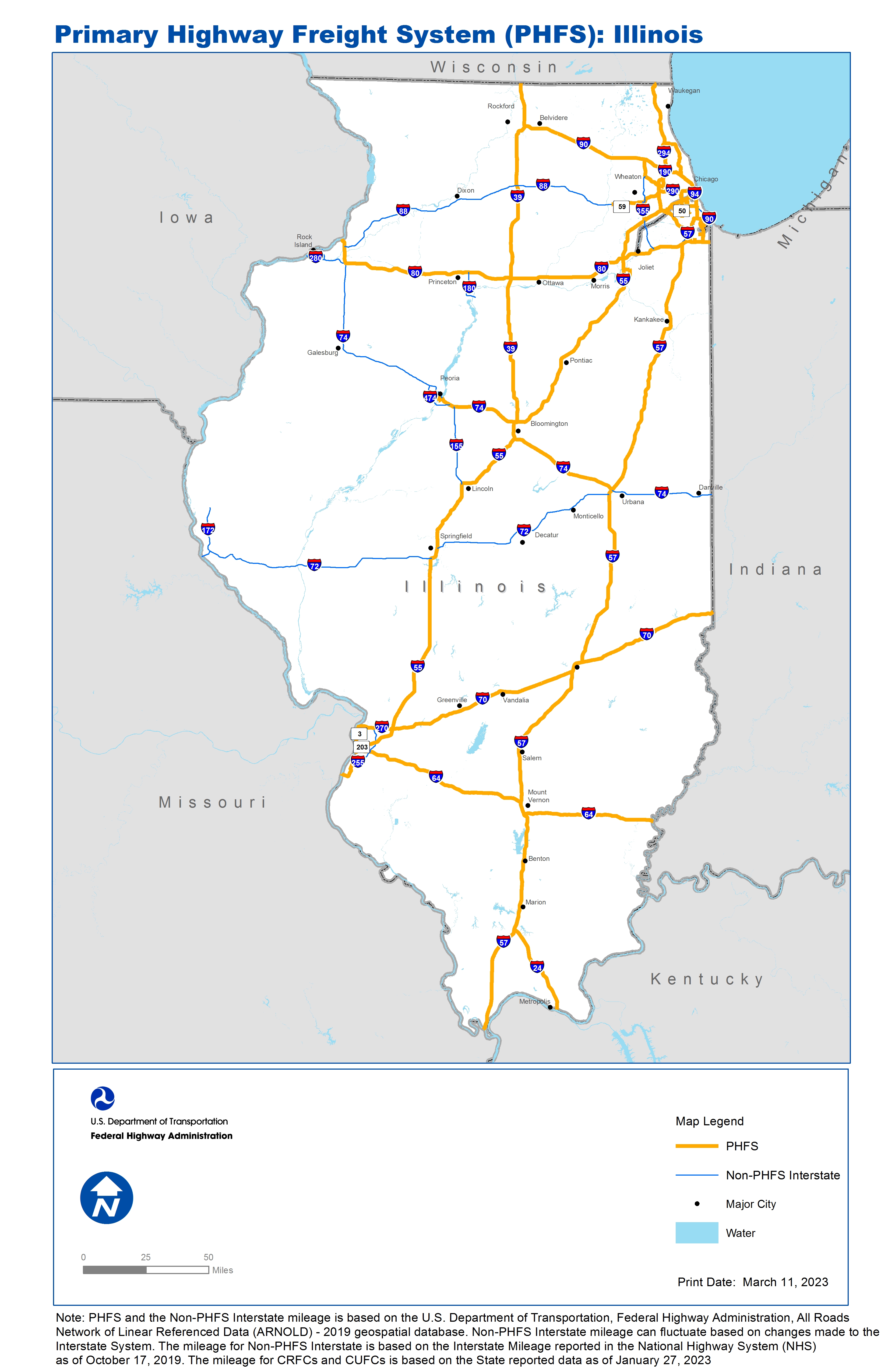
Note: PHFS and the Non-PHFS Interstate mileage is based on the U.S. Department of Transportation, Federal Highway Administration, All Roads Network of Linear Referenced Data (ARNOLD) - 2019 geospatial database. Non-PHFS Interstate mileage can fluctuate based on changes made to the Interstate System. The mileage for Non-PHFS Interstate is based on the Interstate Mileage reported in the National Highway System (NHS) as of October 17, 2019. The mileage for CRFCs and CUFCs is based on the State reported data as of January 27, 2023
Sources
U.S. Department of Transportation, Federal Highway Administration, All Roads Network of Linear Referenced Data (ARNOLD) 2019.