National Highway Freight Network Map and Tables for California, 2022


High-Resolution Images
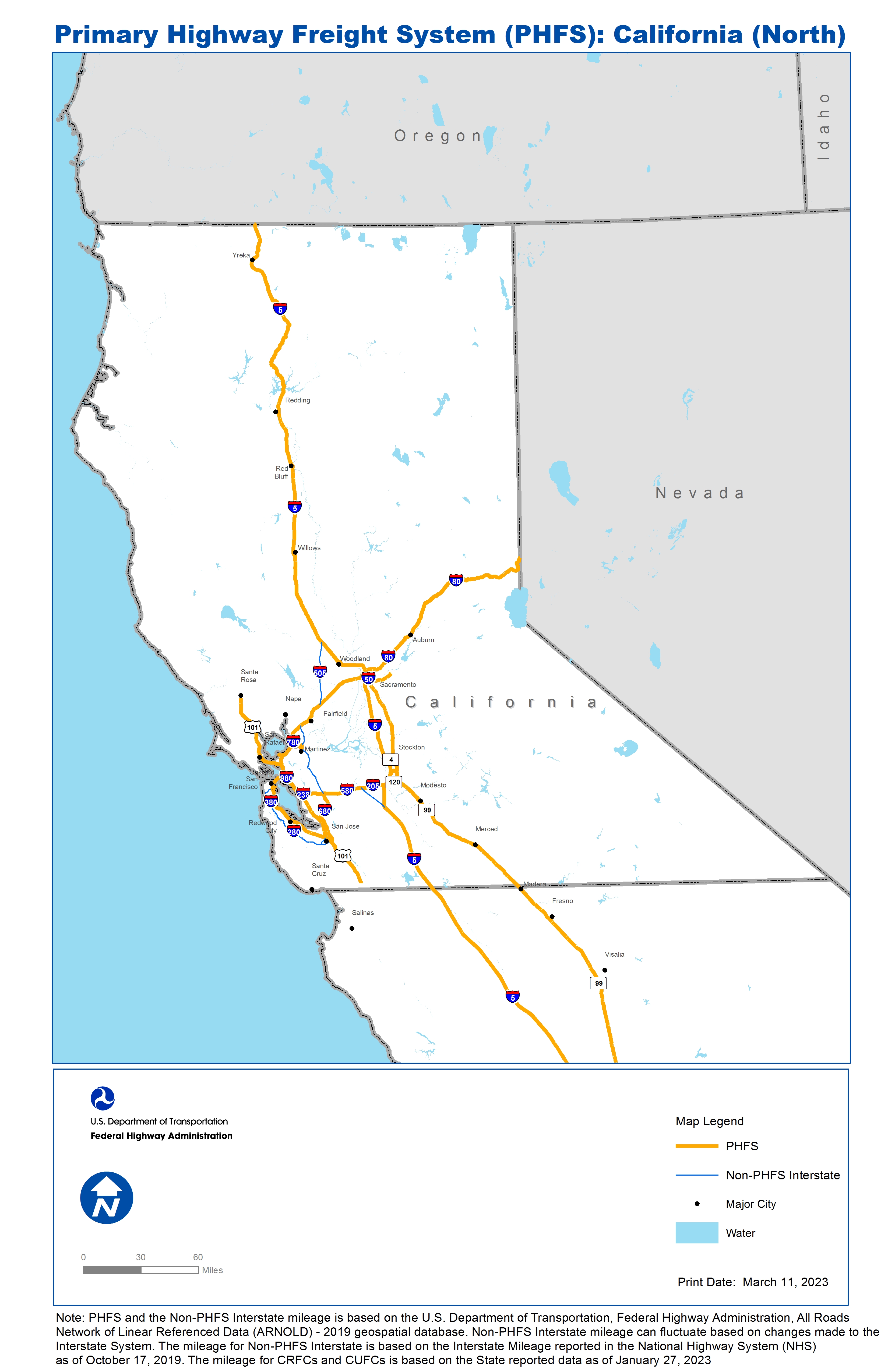
California
- JPG 2.6 MB
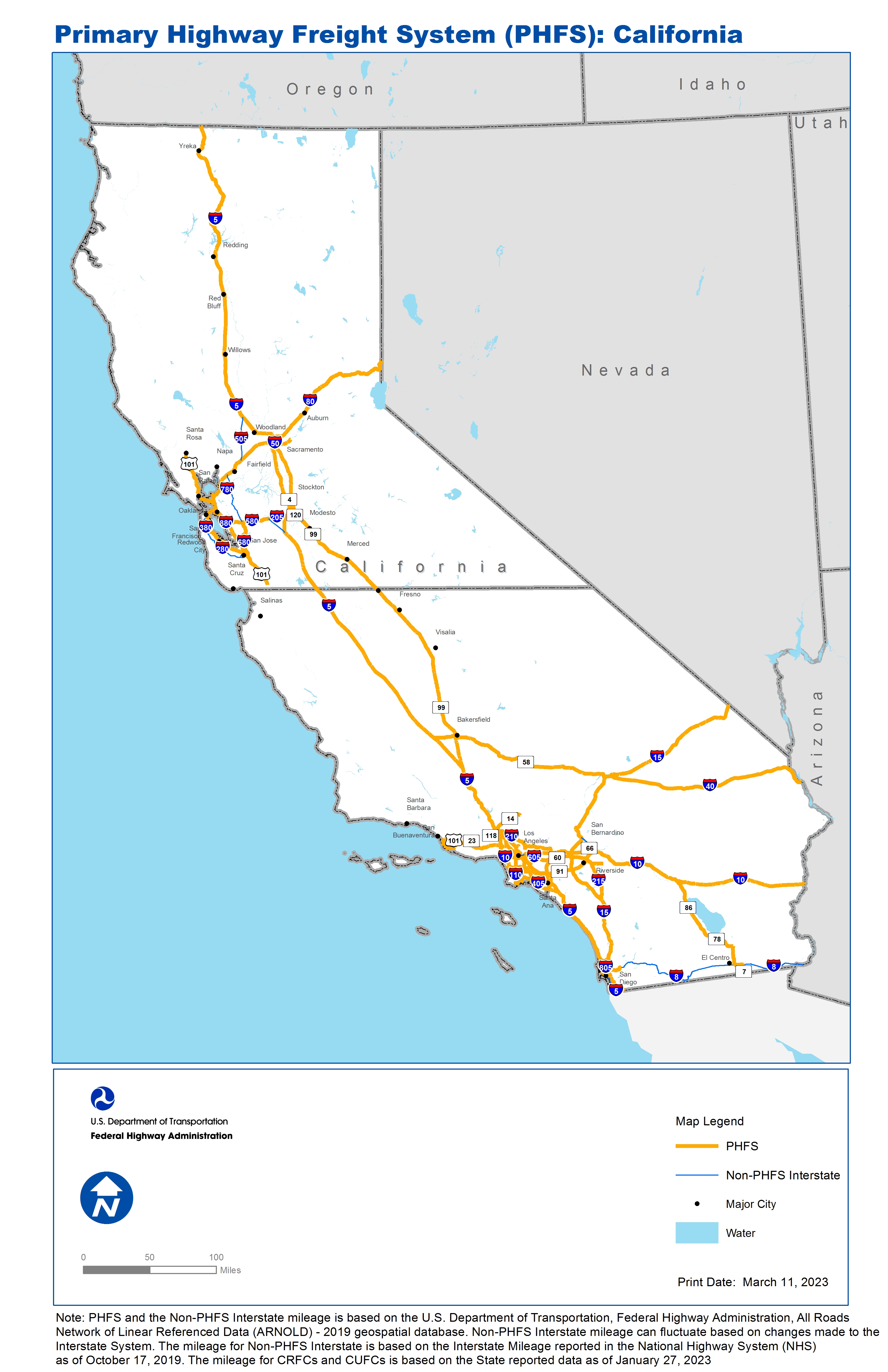
- JPG 2.4 MB
Southern California
- JPG 2.6 MB
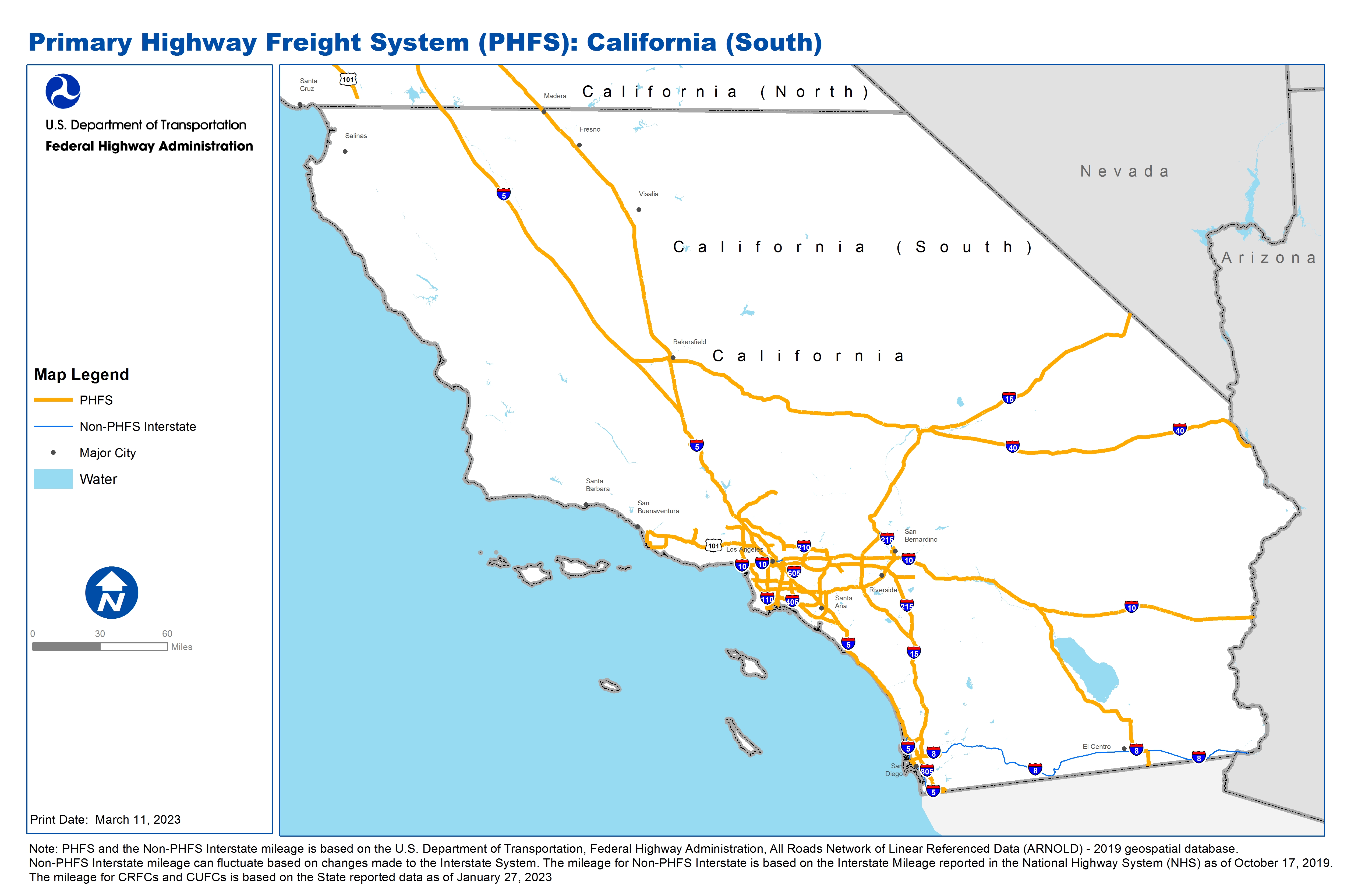
Table of National Highway Freight Network Routes, 2022
|
State |
Route No/ Facility Name |
Start Point |
End Point |
Route/Facility Description |
Length (Miles) |
|---|---|---|---|---|---|
CA |
Figueroa St |
CA30P |
I110 |
Figueroa St from CA30P to I110 |
0.17 |
CA |
I10 |
I405 |
I5 |
I10 from I405 to I5 |
12.93 |
CA |
I10 |
I710 |
CA/AZ Line |
I10 from I710 to CA/AZ Line |
221.73 |
CA |
I105 |
CA3A |
I605 |
I105 from CA3A to I605 |
17.32 |
CA |
I110 |
S47 |
I10 |
I110 from S47 to I10 |
20.45 |
CA |
I15 |
I8 |
CA/NV Line |
I15 from I8 to CA/NV Line |
287.32 |
CA |
I205 |
I580 |
I5 |
I205 from I580 to I5 |
12.98 |
CA |
I210 |
I5 |
I10 |
I210 from I5 to I10 |
44.67 |
CA |
I215 |
I15 |
S30 |
I215 from I15 to S30 |
46.24 |
CA |
I238 |
I880 |
I580 |
I238 from I880 to I580 |
2.18 |
CA |
I305 |
CA34P |
I80 |
I305 from CA34P to I80 |
1.25 |
CA |
I305 |
I5 |
S99 |
I305 from I5 to S99 |
2.13 |
CA |
I40 |
I15 |
CA/AZ Line |
I40 from I15 to CA/AZ Line |
154.61 |
CA |
I405 |
I5 |
I5 |
I405 from I5 to I5 |
72.41 |
CA |
I5 |
W Grape St |
I8 |
I5 from W Grape St to I8 |
3.21 |
CA |
I5 |
I805 |
CA/OR Line |
I5 from I805 to CA/OR Line |
766.06 |
CA |
I580 |
U101 |
I80 |
I580 from U101 to I80 |
13.06 |
CA |
I580 |
I238 |
I205 |
I580 from I238 to I205 |
30.60 |
CA |
I605 |
I405 |
I210 |
I605 from I405 to I210 |
27.59 |
CA |
I680 |
CA40P |
I780 |
I680 from CA40P to I780 |
1.44 |
CA |
I680 |
U101 |
I580 |
I680 from U101 to I580 |
31.01 |
CA |
I710 |
CA29P |
I10 |
I710 from CA29P to I10 |
21.25 |
CA |
I780 |
CA40P |
I80 |
I780 from CA40P to I80 |
6.80 |
CA |
I8 |
I5 |
0.17 Miles East of S67 |
I8 from I5 to 0.17 Miles East of S67 |
16.00 |
CA |
I8 |
S111 |
S7 |
I8 from S111 to S7 |
6.83 |
CA |
I80 |
U101 |
CA/NV Line |
I80 from U101 to CA/NV Line |
203.80 |
CA |
I805 |
S905 |
I5 |
I805 from S905 to I5 |
26.73 |
CA |
I880 |
U101 |
I80 |
I880 from U101 to I80 |
41.93 |
CA |
Miramar Rd |
I805 |
I15 |
Miramar Rd from I805 to I15 |
5.27 |
CA |
S111 |
I8 |
S78 |
S111 from I8 to S78 |
14.31 |
CA |
S118 |
I405 |
8.19 Miles West of I405 |
S118 from I405 to 8.19 Miles West of I405 |
8.14 |
CA |
S120 |
I5 |
S99 |
S120 from I5 to S99 |
6.38 |
CA |
S134 |
I5 |
2.39 Miles East of I5 |
S134 from I5 to 2.39 Miles East of I5 |
2.62 |
CA |
S14 |
I5 |
23.45 Miles Northeast of I5 |
S14 from I5 to 23.45 Miles Northeast of I5 |
23.19 |
CA |
S170 |
U101 |
I5 |
S170 from U101 to I5 |
6.05 |
CA |
S22 |
I405 |
I5 |
S22 from I405 to I5 |
9.89 |
CA |
S23 |
U101 |
6.85 Miles North of U101 |
S23 from U101 to 6.85 Miles North of U101 |
6.80 |
CA |
S4 |
I5 |
S99 |
S4 from I5 to S99 |
4.11 |
CA |
S47 |
CA30P |
I110 |
S47 from CA30P to I110 |
2.00 |
CA |
S55 |
I405 |
S91 |
S55 from I405 to S91 |
11.82 |
CA |
S57 |
I5 |
S60 |
S57 from I5 to S60 |
16.42 |
CA |
S57 |
S60 |
I210 |
S57 from S60 to I210 |
7.79 |
CA |
New S58 |
S99 |
I5 |
New S58 from S99 to I5 |
17.79 |
CA |
S58 |
S99 |
I15 |
S58 from S99 to I15 |
125.83 |
CA |
S60 |
I10 |
I215 |
S60 from I10 to I215 |
52.84 |
CA |
S60 |
I215 |
8.90 Miles East of I215 |
S60 from I215 to 8.90 Miles East of I215 |
8.90 |
CA |
S7 |
MX/CA Line |
I8 |
S7 from MX/CA Line to I8 |
7.23 |
CA |
S71 |
S60 |
3.63 Miles South of S71 |
S71 from S60 to 3.63 Miles South of S71 |
3.88 |
CA |
S710 |
I210 |
2.17 Miles South of I210 |
S710 from I210 to 2.17 Miles South of I210 |
2.17 |
CA |
S78 |
S111 |
S86 |
S78 from S111 to S86 |
25.12 |
CA |
S86 |
S78 |
I10 |
S86 from S78 to I10 |
46.92 |
CA |
S905 |
MX/CA Line |
I805 |
S905 from MX/CA Line to I805 |
6.55 |
CA |
S91 |
I110 |
I215 |
S91 from I110 to I215 |
58.83 |
CA |
S99 |
I5 |
I305 |
S99 from I5 to I305 |
298.94 |
CA |
U101 |
CA36P |
I5 |
U101 from CA36P to I5 |
64.17 |
CA |
U101 |
I80 |
26.12 Miles South of I680 |
U101 from I80 to 26.12 Miles South of I680 |
75.75 |
CA |
U101 |
I580 |
6.38 Miles North of S116 |
U101 from I580 to 6.38 Miles North of S116 |
36.43 |
CA |
U50 |
S99 |
12.61 Miles East of S99 |
U50 from S99 to 12.61 Miles East of S99 |
12.61 |
CA |
W Willow St |
CA61R |
I710 |
W Willow St from CA61R to I710 |
0.81 |
CA |
La Media Rd |
S905 |
USA-Mex Border (Otay Mesa POE) |
La Media Rd from S905 to USA-Mex Border (Otay Mesa POE) |
2.35 |
CA |
CA1A - Burbank - Glendale Airport |
I-5 |
Burbank - Glendale Airport |
Thornton Av. (Airport to Buena Vista), Buena Vista St. (Thornton to I-5). |
0.87 |
CA |
CA29P - Port of Long Beach |
Alameda |
Port of Long Beach |
Ocean Blvd (Port to SR-710), 9th/10th St (Santa Fe to Pico), Pico Ave (9th/10th to Ocean Blvd), Santa Fe (Anaheim to 9th), Anaheim St (Santa Fe to Alameda) |
2.03 |
CA |
CA30P - Port of Los Angeles |
Anaheim St |
Port of Los Angeles |
Seaside Ave/Rte. 47: LB City limit e/o Navy Wy to beginning of Rte. 47. N Front St: Rte. 47 to John S Gibson Blvd. Harry Bridges Blvd/B: Figueroa St to Alameda St; Alameda St: Harry Bridges Bl ('B' St) to Anaheim St. |
4.54 |
CA |
CA31P - Port of San Francisco |
Rt 101 |
Port of San Francisco |
Cargo Way (Jennings to 3rd), 3rd St (Cargo Way to Cesar Chavez), Cesar Chavez St (3rd St to Rt 101) - (Cargo Way proposed). |
1.86 |
CA |
CA32P - Port of Oakland |
I-880 |
Port of Oakland |
Maritime St (7th to W Grand Ave), W Grand Ave (Maritime to I-880), 7th St (Maritime to I-880). |
2.26 |
CA |
CA33P - Port of Richmond |
I-580 |
Port of Richmond |
Harbor Way (Terminal to I-580). Canal Blvd (Terminal to I-580). . |
0.90 |
CA |
CA34P - Port of Sacramento |
US50 |
Port of Sacramento |
Enterprise Blvd (Industrial Rd to I-80), Industrial Blvd (Enterprise Blvd to Harbor Blvd), Harbor Blvd (Industrial Blvd to US50). |
0.39 |
CA |
CA35P - Port of Redwood City |
Rt. 101 |
Port of Redwood City |
Seaport Blvd. (Port to Rt. 101). Bloomquist St (seaport Blvd to Maple), Maple St (Bloomquist to Facility). |
1.10 |
CA |
CA36P - Port Hueneme |
US 101 |
Port Hueneme |
Hueneme Rd (Port to Los pasos), Los pasos (Heueneme to US 101). Ventura Rd (Hueneme to Channel Island), channel Island Blvd (Ventura to Victoria), Victoria Ave (Channel Island to US 101). . |
20.21 |
CA |
CA39P - Channel Islands Harbor |
Rt 101 |
Channel Islands Harbor |
Victoria Ave (Terminal to Rt 101) mileage include in CA36P. |
0.00 |
CA |
CA3A - Los Angeles International Airport |
I-105 |
Los Angeles International Airport |
Sepulveda Blvd (Century to I-105) |
0.98 |
CA |
CA40P - Port of Benicia |
I-680 |
Port of Benicia |
Bayshore Rd. (Port to Park), Park Rd. (Bayshore to Industrial), Industrial Way (Park to I-680). |
2.44 |
CA |
CA41P - Port of Stockton |
I-5 |
Port of Stockton |
Harbor St (Terminal to Fresno), Fresno Ave (Harbor to Navy), Navy Dr (W Washington to Charter Way), Charter Way (Navy to I-5), @ Washington St (Navy to Fresno). |
1.81 |
CA |
CA4A - Oakland International Airport |
I-880 |
Oakland International Airport |
Airport Dr (Hegenberger to Doolittle), Hegenberger Dr (Doolittle to I-880), 98th Ave (Airport Dr to I-880). |
1.03 |
CA |
CA5A - Ontario International Airport |
Rt. 10 |
Ontario International Airport |
Archibald Av (Airport to Rt 10). Vineyard Av. (Airport to Rt. 10). |
0.93 |
CA |
CA60R - Fresno TOPC Rail Yard |
Rt.99 |
Fresno TOPC Rail Yard |
North Ave. (Facility to Rt.99). |
0.58 |
CA |
CA61R - Long Beach (Carson) Rail Yard |
Rt. 47 |
Long Beach (Carson) Rail Yard |
Sepulveda Blvd. (Facility to Rt. 47). |
0.75 |
CA |
CA62R - Oakland Rail Yard |
I-880 |
Oakland Rail Yard |
Middle Harbor Rd (7th St to I-880). |
1.27 |
CA |
CA63R - Lathrop Rail Yard |
Rte. 99 |
Lathrop Rail Yard |
E Roth Rd (Lathrop Rlyd IFC Airport Wy to I-5), Airport Wy (E Roth Rd to French Camp Rd), French Camp Rd (Airport Wy to Rte 99). |
4.84 |
CA |
CA64R - LA (Nr. Union Station) |
I-5 |
LA (Nr. Union Station) |
Lamar St (Station to N Main), N Main St (Lamar to Daly), Daly St (N Main to N Mission), Mission Rd (Daly to I-5). Ave 20 (N Main to N Broadway), N Broadway (Ave 20 to I-5). |
1.09 |
CA |
CA65R - Richmond Rail Yard |
Rt. 580 |
Richmond Rail Yard |
Canal Blvd. (Facility to Rt. 580). |
1.45 |
CA |
CA66R - LA ATSF Rail Yard |
I-710 |
LA ATSF Rail Yard |
Washington Blvd (Hobart Yard to I-710). Shelia St (Arrowmile to Atlantic), Atlantic Blvd (Shelia to Bandini), Bandini Blvd (S Downey to I-710) - Connector 2 is proposed). . |
1.36 |
CA |
CA67R - Stockton Rail Yard |
Rte 99 |
Stockton Rail Yard |
Anderson St (Facility to Diamond St), Diamond St (Anderson to Mariposa Rd), Mariposa Rd (Diamond St to Rte 99), Charter Wy (Diamond St to Rte 99). |
1.57 |
CA |
CA68R - San Bernadino Rail Yard |
I-215 |
San Bernadino Rail Yard |
2nd St (I-215 to Mt Vernon), Mount Vermont (4th St to Rialto), 4th St (Mt Vernon to 5th), Rialto Ave (Mt Vernon to Sidewinder Mountain Rd) |
1.79 |
CA |
CA69R - City of Industry Rail Yard |
SR 60 |
City of Industry Rail Yard |
Azusa Ave (Anaheim-Puente Rd to SR 60), (Anaheim-Puneta Rd to Arenth Ave). Fullerton Rd (Arenth Ave to SR 60). |
1.05 |
CA |
CA78R - UPS - Richmond Terminal |
I-80 |
UPS - Richmond Terminal |
Atlas Rd (Facility to Richmond Pk), Richmond Pkwy (Atlas to I-80). |
2.17 |
CA |
CA7A - Lindbergh Field - San Diego |
I-5 |
Lindbergh Field - San Diego |
N. Harbor Dr. (Seaplane Wy to W. Laurel St.), W. Laurel St (N. Harbor Dr to I-5), W Washington St (I-5 to Pacific Hwy), Pacific Hwy (W Washington St to Laurel St) |
2.11 |
CA |
CA8A - San Francisco Intl Airport |
US 101 |
San Francisco Intl Airport |
San Bruno Ave (US 101 to Airport Entrance). |
0.29 |
PHFS Total |
|
|
|
|
3,126.28 |
|
State |
Route No/ Facility Name |
Start Point |
End Point |
Route/Facility Description |
Length (Miles) |
|---|---|---|---|---|---|
CA |
I10 |
Lincoln Blvd |
I405 |
I10 from Lincoln Blvd to I405 |
3.30 |
CA |
I10 |
I5 |
I710 |
I10 from I5 to I710 |
2.95 |
CA |
I215 |
Highland Ave |
I15 (North) |
I215 from Highland Ave to I15 (North) |
8.85 |
CA |
I280 |
6th St |
I101 (South) |
I280 from 6th St to I101 (South) |
57.17 |
CA |
I305 |
I5 |
Harbor Blvd |
I305 from I5 to Harbor Blvd |
2.31 |
CA |
I380 |
I280 |
U101 |
I380 from I280 to U101 |
1.67 |
CA |
I5 |
MX/CA Line |
Grape St |
I5 from MX/CA Line to Grape St |
16.52 |
CA |
I5 |
I8 |
I805 (North) |
I5 from I8 to I805 (North) |
10.64 |
CA |
I505 |
I5 |
I80 |
I505 from I5 to I80 |
32.98 |
CA |
I580 |
I880 |
Grand Ave |
I580 from I880 to Grand Ave |
3.13 |
CA |
I580 |
0.31 Miles North of Fairmont Dr |
I238 |
I580 from 0.31 Miles North of Fairmont Dr to I238 |
2.34 |
CA |
I580 |
I205 |
I5 |
I580 from I205 to I5 |
16.03 |
CA |
I680 |
I80 |
CA40P |
I680 from I80 to CA40P |
11.09 |
CA |
I680 |
I780 |
I580 |
I680 from I780 to I580 |
28.33 |
CA |
I8 |
0.17 Miles East of S67 |
S111 |
I8 from 0.17 Miles East of S67 to S111 |
100.01 |
CA |
I8 |
S78 |
CA/AZ Line |
I8 from S78 to CA/AZ Line |
47.12 |
CA |
I805 |
I5 (South) |
S905 |
I805 from I5 (South) to S905 |
1.60 |
CA |
I880 |
I280 |
0.13 Miles South of U101 |
I880 from I280 to 0.13 Miles South of U101 |
4.08 |
CA |
I980 |
I880 |
I580 |
I980 from I880 to I580 |
2.00 |
INTERSTATE NON-PHFS Total |
|
|
|
|
352.12 |
Note: PHFS and the Non-PHFS Interstate mileage is based on the U.S. Department of Transportation, Federal Highway Administration, All Roads Network of Linear Referenced Data (ARNOLD) - 2019 geospatial database. Non-PHFS Interstate mileage can fluctuate based on changes made to the Interstate System. The mileage for Non-PHFS Interstate is based on the Interstate Mileage reported in the National Highway System (NHS) as of October 17, 2019. The mileage for CRFCs and CUFCs is based on the State reported data as of January 27, 2023
Sources
U.S. Department of Transportation, Federal Highway Administration, All Roads Network of Linear Referenced Data (ARNOLD) 2019.