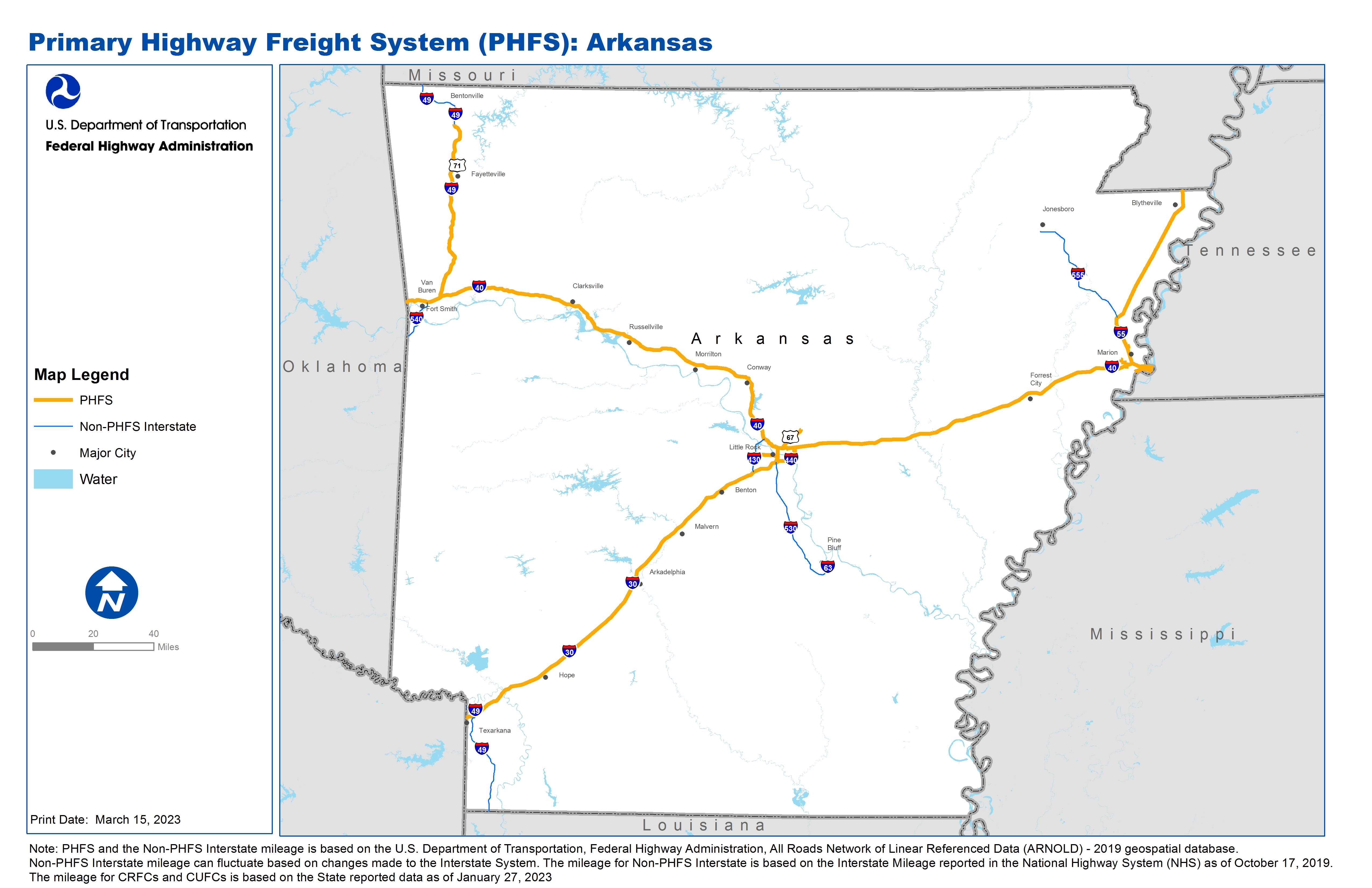
National Highway Freight Network Map and Tables for Arkansas, 2022

High-Resolution Images
- JPG 2.9MB
Table of National Highway Freight Network Routes, 2022
|
State |
Route No/ Facility Name |
Start Point |
End Point |
Route/Facility Description |
Length (Miles) |
|---|---|---|---|---|---|
AR |
I30 |
TX/AR Line |
I40 |
I30 from TX/AR Line to I40 |
142.91 |
AR |
I40 |
OK/AR Line |
AR/TN Line |
I40 from OK/AR Line to AR/TN Line |
284.44 |
AR |
I440 |
I30 |
I40 |
I440 from I30 to I40 |
10.42 |
AR |
I49 |
0.23 Miles South of W new Hope Rd |
I40 |
I49 from 0.23 Miles South of W new Hope Rd to I40 |
63.46 |
AR |
I55 |
TN/AR Line |
I40 |
I55 from TN/AR Line to I40 |
4.44 |
AR |
I55 |
I40 |
AR/MO Line |
I55 from I40 to AR/MO Line |
65.15 |
AR |
I630 |
I30 |
I430 |
I630 from I30 to I430 |
8.00 |
AR |
U67 |
I40 |
W Main St |
U67 from I40 to W Main St |
9.07 |
AR |
Fulbright Expwy |
I49 |
N College Ave |
Fulbright Expwy from I49 to N College Ave |
1.95 |
AR |
AR10P - Little Rock Port Complex, Little Rock |
I440 |
Little Rock Port Complex, Little Rock |
From I-440 (exit 5): S 0.27 mile on Fourche Dam Pike, NE 0.76 mile on Lindsey Rd, E 0.43 mile on Industrial Harbor Dr, S 0.20 mile on Slackwater Harbor Dr, E 0.40 mile on Intermodal Loop Dr to entrance |
2.00 |
AR |
AR11R - Union Pacific Ebony Terminal, West Memphis |
I40 |
Union Pacific Ebony Terminal, West Memphis |
From I-40 (EX 275): N 1.23 miles on SH 118, W 1.76 miles on Red Cross Rd, N 1.09 mile on Kuhn Rd to the intermodal terminal. . . |
4.84 |
AR |
AR13L - Central AR Pipeline/Fuel Storage Complex, North Little Rock |
I440 |
Central AR Pipeline/Fuel Storage Complex, North Little Rock |
From I-440(EX 10): W 0.98 mile on US 70, N 0.90 mile on Central Airport Rd. |
1.78 |
AR |
AR16L - Truman Arnold Fuel Storage Complex, West Memphis |
I40 |
Truman Arnold Fuel Storage Complex, West Memphis |
From I-40 (EX 280): SW 0.66 mile on Martin Luther King, Jr. Dr, S 0.10 mile on SH 38 (MLK, Jr. Dr), S and SW 2.44 miles on South Loop, N 0.20 mile on S 8th St. |
3.25 |
AR |
AR18R - Burlington Northern & Santa Fe Intermodal Terminal, Sunset |
I55 |
Burlington Northern & Santa Fe Intermodal Terminal, Sunset |
From I-55 (EX 14): E 0.71 mile on Co. Rd. 4, S 1.38 miles on Hwy 77. |
2.02 |
AR |
AR7R - Union Pacific Rail/Truck Ramp, North Little Rock |
I40 |
Union Pacific Rail/Truck Ramp, North Little Rock |
From I-40 (EX 157): SE 0.49 mile on SH 161, W 0.92 mile on Bethany Rd. |
1.12 |
PHFS Total |
|
|
|
|
604.85 |
|
State |
Route No/ Facility Name |
Start Point |
End Point |
Route/Facility Description |
Length (Miles) |
|---|---|---|---|---|---|
AR |
I430 |
I30 |
I40 |
I430 from I30 to I40 |
12.86 |
AR |
I530 |
U65 |
I30 |
I530 from U65 to I30 |
45.94 |
AR |
I540 |
23.84 Miles South of U62 |
U62 |
I540 from 23.84 Miles South of U62 to U62 |
14.32 |
AR |
I49 |
0.23 Miles South of W new Hope Rd |
0.48 Miles South of U62 |
I49 from 0.23 Miles South of W new Hope Rd to 0.48 Miles South of U62 |
2.66 |
AR |
I49 |
0.48 Miles South of U62 |
MO/AR Line |
I49 from 0.48 Miles South of U62 to MO/AR Line |
19.85 |
AR |
I49 |
LA/AR Line |
TA/AR Line |
I49 from LA/AR Line to TA/AR Line |
41.47 |
AR |
I555 |
I55 |
U49 |
I555 from I55 to U49 |
44.06 |
INTERSTATE NON-PHFS Total |
181.16 |
Note: PHFS and the Non-PHFS Interstate mileage is based on the U.S. Department of Transportation, Federal Highway Administration, All Roads Network of Linear Referenced Data (ARNOLD) - 2019 geospatial database. Non-PHFS Interstate mileage can fluctuate based on changes made to the Interstate System. The mileage for Non-PHFS Interstate is based on the Interstate Mileage reported in the National Highway System (NHS) as of October 17, 2019. The mileage for CRFCs and CUFCs is based on the State reported data as of January 27, 2023
Sources
U.S. Department of Transportation, Federal Highway Administration, All Roads Network of Linear Referenced Data (ARNOLD) 2019.