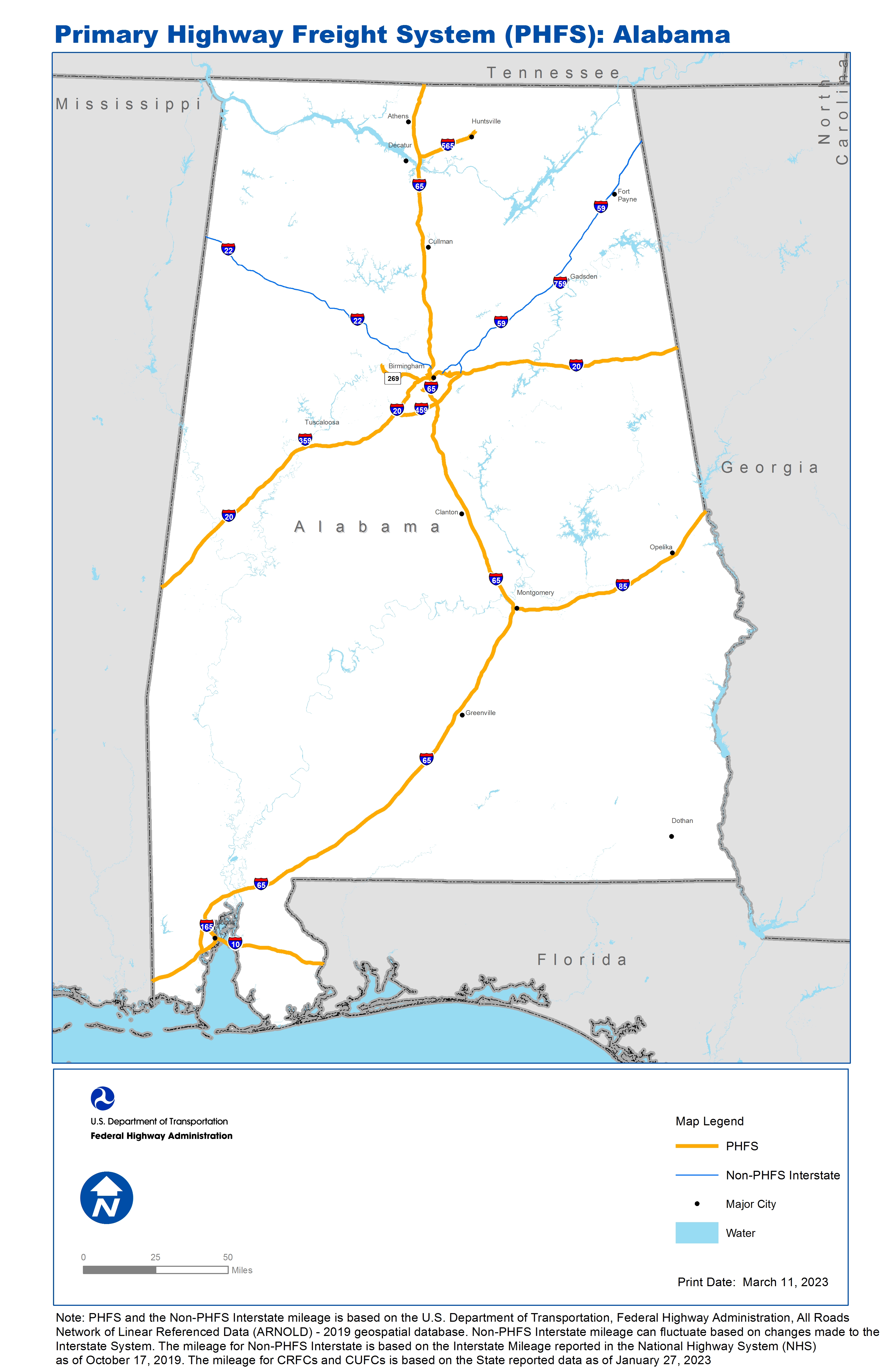
National Highway Freight Network Map and Table for Alabama, 2022

High-Resolution Images
- JPG 2.9MB
Table of National Highway Freight Network Routes, 2022
State |
Route No/ Facility Name |
Start Point |
End Point |
Route/Facility Description |
Length (Miles) |
|---|---|---|---|---|---|
AL |
I10 |
MS/AL Line |
AL/FL Line |
I10 from MS/AL Line to AL/FL Line |
66.32 |
AL |
I165 |
AL7P |
I65 |
I165 from AL7P to I65 |
4.90 |
AL |
I20 |
MS/AL Line |
AL/GA Line |
I20 from MS/AL Line to AL/GA Line |
214.80 |
AL |
I459 |
I20 |
I20 |
I459 from I20 to I20 |
29.56 |
AL |
I565 |
I65 |
U72 |
I565 from I65 to U72 |
22.12 |
AL |
I65 |
I10 |
AL/TN Line |
I65 from I10 to AL/TN Line |
366.22 |
AL |
I85 |
I65 |
AL/GA Line |
I85 from I65 to AL/GA Line |
80.19 |
AL |
AL11P - Port Birmingham - North Terminal |
I20 |
Port Birmingham - North Terminal |
AL 269 (Port to I-20) |
17.46 |
AL |
AL14L - Colonial Pipeline |
I65 |
Colonial Pipeline |
Facility to 28th St. to Balsam Ave. to Nabors Rd. to Ishkooda Rd. to Spaulding-Ishkooda Rd. to I-65. |
3.67 |
AL |
AL15R - Ernest Norris RR Yards |
I20 |
Ernest Norris RR Yards |
Entrance at Norfolk Southern Dr. to Ruffner Rd. to 16th St. to US 78 to Kilgore Mem. Dr. to I-20. |
2.88 |
AL |
AL4R - Burlington Northern RR Dixie Hub Center |
I65 |
Burlington Northern RR Dixie Hub Center |
Finley Ave. to I-65 and U.S. 78 West. |
1.67 |
AL |
AL7P - Alabama State Docks (Freight Docks) |
I165 |
Alabama State Docks (Freight Docks) |
Beauregard St and The Robert Hope Bridge from the Facility to Water St and I-165. |
1.39 |
AL |
AL9R - Brookley Industrial Complex |
I10 |
Brookley Industrial Complex |
Michigan Ave (Ave I to I-10). |
0.65 |
PHFS Total |
|
|
|
|
811.83 |
State |
Route No/ Facility Name |
Start Point |
End Point |
Route/Facility Description |
Length (Miles) |
|---|---|---|---|---|---|
AL |
I359 |
I20 |
U11 |
I359 from I20 to U11 |
2.23 |
AL |
I459 |
I20 |
I59 |
I459 from I20 to I59 |
4.23 |
AL |
I59 |
I20 |
AL/GA Line |
I59 from I20 to AL/GA Line |
111.10 |
AL |
I759 |
U411 |
I59 |
I759 from U411 to I59 |
4.87 |
AL |
I22 |
MS/AL Line |
I65 |
I22 from MS/AL line to I65 |
96.34 |
INTERSTATE NON-PHFS Total |
218.77 |
Note: PHFS and the Non-PHFS Interstate mileage is based on the U.S. Department of Transportation, Federal Highway Administration, All Roads Network of Linear Referenced Data (ARNOLD) - 2019 geospatial database. Non-PHFS Interstate mileage can fluctuate based on changes made to the Interstate System. The mileage for Non-PHFS Interstate is based on the Interstate Mileage reported in the National Highway System (NHS) as of October 17, 2019. The mileage for CRFCs and CUFCs is based on the State reported data as of January 27, 2023
Sources
U.S. Department of Transportation, Federal Highway Administration, All Roads Network of Linear Referenced Data (ARNOLD) 2019.