Evaluation of Travel Time Methods to Support Mobility Performance Monitoring:
World Trade Bridge (Page 2 of 5)
Data Collection Process
For this study, two data collection locations were used in each direction. The "number 1" locations were located to the north or south of where the truck cues were anticipated to form due to backups at the primary Customs location or export booths. The "number 2" location was immediately after the primary inspection booths. For consistency among all border crossings visited for the overall project, the data collection positions were distinguished by whether they were leaving the United States (outbound) or entering the United States (inbound). For the Laredo border crossing, outbound was designated as southbound indicating that the trucks were traveling into Mexico. Inbound was designated as northbound indicating that the trucks were traveling into the United States.
Each data collector would use a handheld computer to record partial license plate information of all commercial vehicles that passed their location. The computer would also store the time that each license plate was entered. The data from the two locations in each direction would be combined, allowing the determination of the travel time for each vehicle that was recorded at both locations.
For the data collection, the on-site team included four data collectors and two supervisors. Thus, three team members were located in each country. The hours during which data were collected were selected to encompass the greatest number of daylight hours after the 8:00 AM World Trade Bridge opening. They were selected from discussions with knowledgeable officials. Table 2 shows the data collection hours for each day during the site visit. Data collection extended about 10 hours and included the periods when the supervisor collected data during break periods and the meal period.
Figure 3 shows the Laredo, Texas portion of the World Trade Complex. The data collection points are marked on the map. OB-1 is the location of the data collector recording data on trucks moving into Mexico. OB-1A is the location that the collector moved to when there was a backup from the Mexican side. IB-2 is the data collection location for trucks coming from Mexico and leaving the U.S. Primary Customs booths.
On the Mexican side of the border, trucks approach the World Trade Bridge on a divided highway with two lanes in each direction. The inbound trucks pass through the export booths of the Douanas (Customs). A small percentage of trucks may be stopped for an additional export inspection but the great majority proceeds through the bridge tollbooths across the bridge to the U.S. side of the border. Trucks moving south into Mexico pass the primary import booths, a small fraction are diverted through an import inspection area then all trucks pass through a secondary inspection booth before preceding on to the divided highway. Figure 4 shows the location of the data collection points for both the inbound and outbound directions. The IB-1 location was located at the point where the trucks turned to head to the export booths. The OB-2 location was established to provide the best view of the front of the trucks as they passed through the Mexican Customs import booths. Figures 5 through 9 show pertinent views of the U.S. and Mexican sides of the World Trade Bridge.
For both directions in Mexico, there was a special lane for empty vehicles. These included both bobtails and tractors pulling empty trailers. The study team hypothesized that travel times could differ between empty and full vehicles. Consequently the characters SC (Sin Carga) were included to denote empty vehicles and to enable comparisons of travel delay times between the loaded and unloaded trucks.
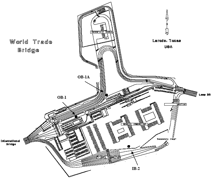
Figure 3. Laredo, Texas Layout and Data Collection Locations
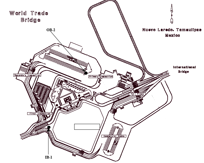
Figure 4. Nuevo Laredo Layout and Data Collection Locations
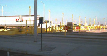
Figure 5. Outbound Toll Booths at the World Trade Bridge
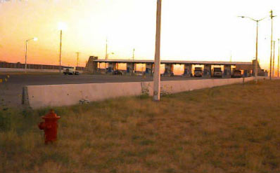
Figure 6. Primary Customs Viewed from the IB-2 Data Collection Location
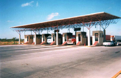
Figure 7. Inbound Access Booths (Export Booths) in Nuevo Laredo
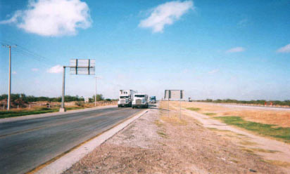
Figure 8. Access Road Approaching the World Trade Bridge in Nuevo Laredo
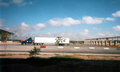
Figure 9. Outbound Import Booths in Nuevo Laredo
| Date | Start | End |
|---|---|---|
| 10/30/01 | 8:30 am | 7:00 pm |
| 10/31/01 | 8:30 am | 7:00 pm |
| 11/01/01 | 8:30 am | 7:00 pm |
The arrangements that led to the data collection activities required a considerable number of phone calls, e-mail correspondence, and a site visit. A meeting was held at Laredo, Texas in June 2001 with representatives of Mexican and U.S. Immigration, U.S. Customs, the City of Laredo, the Mexican and American Consuls, and Battelle. In addition, the Battelle representative toured the border area and potential data collection sites with local officials. Table 3 contains a list of those who attended the initial truck travel time delay orientation meeting.
Table 4 contains a list of the key individuals in Mexico who were contacted and their telephone and e-mail information. A separate table is included for contacts in Mexico and the United States. Table 5 includes information on contacts in the United States.
| Contact | Agency |
|---|---|
| Daniel Hernandez Joseph | Mexican Consul, Laredo |
| Thomas Hart Ambruster | American Consul, Nuevo Laredo |
| Gabriel Cortes Sanchez | Mexican Immigration |
| Jose Escamilla | Laredo Bridge System, City of Laredo |
| Rafael Garcia | Laredo Bridge System, City of Laredo |
| Eugenio Garza Jr. | U.S. Customs Port Director, Laredo |
| Francisco Garcia | Chief Inspector, U.S. Customs, World Trade Bridge |
| Rene Leyendecker | U.S. Customs, South Texas Customs Management Center |
| Contact | Agency | Phone/Fax | |
|---|---|---|---|
| Claude Cortez Papi | Secretaría de Comunicaciones y Transportes (SCT) | (52) 55 19 64 84 | CCortezp@sct.gob.mx |
| Victor Rodriguez Baggio | Central de Planeación Aduanera Servicios de Administración Tributaria Secretaría de Hacienda y Crédito Público | (52) 52 28 33 82 | |
| Enrique Garza González | Subgerencia de Innovación y Calidad Nuevo Laredo II Bridge | (52) 87 55 07 12 (Cellular) | |
| Lic. Beatriz Bautista Morgan Subadministradora Nuevo Laredo III |
Subadministradora Nuevo Laredo III Nuevo Laredo III Bridge |
| Contact | Agency | Phone/Fax | |
|---|---|---|---|
| Ana Einohosa | U.S. Customs, Assistant Port Director, Laredo | 956-718-4179 | Ana.Hinojosa@ Customs.treas.gov |
| J.J. Castillo | U.S. Customs | 956-726-2397 | |
| Rene Leyendecker | U.S. Customs | 956-718-4161 ext. 4184 | RENE.LEYENDECKER@Customs.treas.gov |
| Rafael Garcia | Laredo Bridge System, City of Laredo | 956-791-2200 | RGarcia0@ci.Laredo. TX.US |
| Gabriella Salinas | Laredo Bridge System, City of Laredo | 956-791-2200 | |
| Frank Garcia | U.S. Customs, Assistant Port Director, Laredo | 956-794-9401 | |
| Alex Agular | U.S. Customs Supervisor | 956-794-9423 |